1. Nunatak Nature Trail

0

Lee Vining, CA

Cancel

Open app

Search

Nunatak Nature Trail

5.0 (1 review)

Nunatak Nature Trail Photos

More like Nunatak Nature Trail

Recommended Reviews - Nunatak Nature Trail

Your trust is our priority, so businesses can't pay to alter or remove their reviews. Learn more about reviews.
Yelp app icon
Browse more easily on the app
Review Feed Illustration

2 years ago

Helpful 2
Thanks 0
Love this 1
Oh no 0

Verify this business for free

Get access to customer & competitor insights.

Verify this business

Mono Lake Tufa State Reserve

Mono Lake Tufa State Reserve

4.6(159 reviews)
7.2 mi

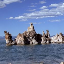
A unique landscape featuring fascinating limestone tufa stone rising from the lake, with beautiful…read moremountain views in the background. Sunrise and sunset are the best times to visit, the sunlight illuminates the tufa towers and creates stunning photo. The shoreline is easily accessible from the parking lot, with easy walks to see the formations up close. However, be prepared for a bit of an unpleasant smell, similar to dead fish, and plenty of flies in some areas along the shore. Parking is $5 per vehicle, payable at the kiosk. Credit cards are accepted, but the payment machine wasn't working on the day of our visit, so be prepared for free parking.

Mono Lake wasn't originally part of our trip, but we decided to stop, and I'm really glad we did :)…read moreI came here as a child but coming back with my own family and friends was awesome. We checked out the Discovery Center with the kids first, then headed down to the lake. It's such a cool place to see in person. The lake is super salty, so you can actually float, which my husband and the kids thought was so much fun! I wasn't brave enough to get in One thing to know before you go, there are tons of tiny brine shrimp in the water, so don't be surprised! They're harmless, just part of the lake's ecosystem but when they got out there were tons in their pockets The tufa towers are really unique and make the whole place feel unlike anywhere else. It's definitely worth walking around and taking in the views and beautiful for photos. If you're driving through the area or anywhere nearby, I'd definitely recommend making a stop. It's a really neat place to see, especially if you've never been before!

Photos
Mono Lake Tufa State Reserve

See all

Mt. Dana

Mt. Dana

5.0(3 reviews)
7.3 mi

The best mountain I have ever climbed was Mt.Whitney. However, I remember Mt.Dana more often. I…read moreclimbed Mt.Dana to acclimatize two days before I climbed Mt.Whitney. Because the purpose of our trip was Mt.Whitney, I was not very excited about climbing Mt.Dana. I know that responsible hikers should always prepare for the trails they plan to hike, but I had been too lazy to print out the trail map of Mt.Dana. Another reason I thought I didn't need to do such preparation was that our leader had done the same trip six years in a row with exactly the same itinerary. So I was planning to follow him and actually I did follow him. It was quite an interesting trail. During the first half, we were able to see a lot of plants and flowers that were specific for high altitudes. On the last half of the trail were only rocks because plants couldn't survive in the higher altitude. There were no obvious trails through the rocks although there were some cairns and flags to show hikers a good path to the summit. I really like this primitive kind of trail. It was stereotypic Eastern Sierra summer scenery; bone dry, brown, and quiet, with strong sunlight. The higher we climbed, the thinner the air became. That made it harder for us to breathe and we stopped talking. I knew that it was only six miles to the crest, but I couldn't see the top. I felt like it would take forever to reach the top. That made me psychologically exhausted. At the same time, I got more time to think by myself. It was hard but I really like this solitude for some reason. When I finally reached the summit, I forgot all the pain. Surprisingly, I was able to see the whole Mono Lake from the top. I had been to Mono Lake but never saw all the lake at one time. It was the most beautiful lake I had ever seen. Because I had not looked up any photos from the summit of Mt.Dana, I was able to be surprised by the scenery. Nature rewards me with great scenery and several kinds of emotion that I never have in daily life. This is the reason I can't stop climbing mountains. Some people believe that mountains have some spiritual power and some places such as Mt.Shasta are known as power spots. I still don't really understand or feel that kind of power, but I got a sense of mountain's strength a little.
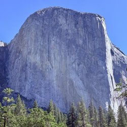
You won't find the Mt. Dana Summit Trail on your National Park Service map and you're unlikely to…read morefind it in your hiking guidebook either. What you will find on this trail however, is a challenging trip up the second highest peak in Yosemite National Park which rewards with some of the best panoramic views you'll experience anywhere.

20 Lakes Basin Loop

20 Lakes Basin Loop

5.0(3 reviews)
3.1 mi

We didn't see 20 lakes in the basin but enjoying nine peaceful mountain lakes during a single day…read morehike was darn fabulous. Located outside the eastern entrance to Yosemite National Park, 2.5 miles of dirt road is crossed to reach the trailhead at the closed Saddlebag Lake Resort at 10087 Saddlebag Lake Road. As a former resort, the location has lots of parking but since the closed buildings meant no running water and an outhouse toilet. The often-closed Tioga Road (aka Hwy 120) must be open to get to Saddlebag. For a longer and harder hike, the basin loop can be reached by going up Lundy Canyon located north of Lee Vining and might be an alternative starting point if Tioga is closed. The loop can begin by heading left across the dam, but we went right around eastern side of Saddlebag Lake - the largest and only man-made lake of the hike. The western side is rocky talus while the eastern trail around Saddlebag Lake is longer but has a more comfortable walking surface that was preferred by people fishing in the lake. The remaining lakes appear at regular half-mile intervals with each having their own flavor. The first set of lakes were small and serene Hummingbird Lake, deep and eerie Odell Lake, and classically graceful Lake Helen. We then took a worthwhile and brief side trip down to Lundy Canyon to the cascading Lundy Canyon Falls. We resumed on the loop to see our favorite Shamrock Lake with multiple little peninsulas poking into the lake which was followed by narrow inlet-like Excelsior Lake, cliff-sided Steelhead Lake below the Sphinx-ish Shepherd Crest, unremarkable Wasco Lake, and meadowy Greenstone Lake before returning along the opposite side of Saddlebag Lake. Maps showed two trails between Steelhead and Wasco Lakes. The western trail is incomplete but also led to the best geology with bold green layered rocks. Our hike was 9.3 miles to circle around nine lakes and one waterfall. The elevation varied from 9,900' to 10,400'. Never steep, the terrain rolled up and down which felt like a 1000' elevation change hike. The paths were mostly exposed with few trees. Located in a true basin, the lakes were surrounded by peaks and ridges. Icy snow pockets that survived the summer ensured water flow through the creeks and lakes.

Hiked this as an overnight backpacking trip with 2 friends in late July, it was the most beautiful…read moreamazing hike I've done and seen in a very long time. Drove up from San Diego the night before and tried to get a camping spot at ~7K feet altitude to get adjusted but all the campsites were full, so ended up camping overnight at disbursed camping down the road (still up at altitude, just no facilities and no fires allowed). Woke up in the morning and made a quick stop at Whoa Nellie Deli to use the bathroom, fill up on water etc. And then drove the very rocky road up to the trailhead. I have a Subaru Impreza, all wheel drive but not a lot of lift, so it was doable, but would have definitely felt better in an SUV, although I also saw a Prius in the parking lot so any car can make it I guess. Parked in the parking lot, there are bear boxes there to leave everything from your car that you're not bringing with you on your backs (also bring a bear canister if you're doing overnight!). Then we headed out. We hiked around the north side of Saddlebag lake, which was beautiful, and a little more crowded as a lot of day hikers just hike that lake. We then took the turn off to the right to head up to the rest of the lakes. On day 1 we did about 6 1/2 miles. We kept passing beautiful lake after beautiful lake. There was a point where we were hiking down a pretty steep climb and it started hailing on us! I was relieved we were hiking down at that point and not up with our packs on. I'd recommend having alltrails map downloaded as there are literally no trail markers, there would have been really know what to know which way to go without it. So we kept hiking and climbing, up and down, around more and more lakes. And then we setup camp for the night around Greenstone Lake. Night 1 was Friday night and was very quiet, no other over-nighters around. Night 2 was a Saturday, and it got a bit more crowded. Nothing too crazy, but there were definitely others in sight and ear-shot. We setup for 2 nights, and then did a day hike the next morning up to Conness Lake which was actually possibly the most beautiful lake I've ever seen in my entire life. I even went swimming in the freezing water! On our last day we woke up in the morning, packed up, and hiked out the remaining 3ish miles back around the bottom of Saddlebag Lake.

Photos
20 Lakes Basin Loop
20 Lakes Basin Loop
20 Lakes Basin Loop

See all

YExplore Yosemite Adventures - Heads in the Clouds on Sentinel Dome

YExplore Yosemite Adventures

4.8(37 reviews)
16.4 mi

I booked a guided snowshoe hike in Yosemite with YExplore as a Christmas gift for my wife Michelle…read moreand I (along with new snowshoes). We are avid hikers and spend a lot of time in Yosemite, but are novices with snowshoes. This was my first time and Michelle's second. We spoke with John on the phone before the trip and explained our goals were to primarily learn about snowshoeing and if possible try a new trail. John brainstormed with us and adjusted the original plan to accommodate both of our goals. Leading up to the trip, Catherine did a fantastic job with communication. She is incredibly detail oriented, professional and friendly. When we arrived at the link up spot, John had already scouted out the trails to make sure the conditions were right to have a good experience. While he certainly can't control the snow, I'm confident he would have been ready with a "Plan B" upon our arrival if required. He was patient as we cut the zip ties off our new shoes, adjusted our poles, and figured out how everything worked, coaching us along the way. The trail was perfect and beautiful and along the way, John took some amazing photos and gave us some photography tips. He explained some of the history of the area and at many points stopped to provide an ecology or history lesson. He was friendly and professional and and we both enjoyed both his company and his coaching. At the end of the day, John air-dropped to us a bunch of amazing photos he had taken along the way. Our objectives were fully accomplished and Michelle and I were both extremely grateful for a wonderful Christmas gift to each other.

Our tour guides were absolutely amazing (John and Mia) and they were very knowledgeable and helped…read moreanswer all of our questions (about Yosemite in general, specific famous features on our hike, and even random questions about birds and plant life). The hike is as advertised (in terms of ratings and what features you will see). They always put safety first and even offered to help carry our back packs when we got tired or were crossing a small stream! They treated us like close family/friends, were encouraging us along the way, and adapted to our pace and schedule. Our group ranged from age 6 to adult and we couldn't have made it to the end of the hike without them! Book them for your tours and have fun on your Yosemite Vacation!

Photos
YExplore Yosemite Adventures - Half Dome

Half Dome

YExplore Yosemite Adventures - Yosemite North Dome Adventure

Yosemite North Dome Adventure

YExplore Yosemite Adventures - Sun on Half Dome

See all

Sun on Half Dome

Nunatak Nature Trail - hiking - Updated October 2026

Loading...
Loading...
Loading...