Panum Crater Photos


More like Panum Crater
Recommended Reviews - Panum Crater
Start your review...

Reviews With Photos

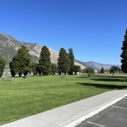
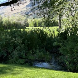
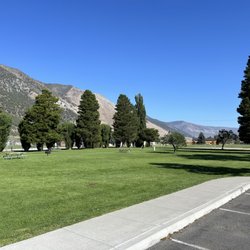
Be ready to huff and puff! Panum Crater is next to Mono Lake right off CA-120, what used to be one of the loneliest roads in America! The crater has two main trails: the Rim Trail and the Plug Trail. The Rim Trail will make you work for it on a hot day! Take a lot of water with you. The Plug Trail is somewhat easier, and depending on the time of the day you may get some shade at stretches. Do not try any of the unofficial trail, because you could easily get lost down there or get hurt walking over glassy volcanic rubble that covers your path. Both trails provide nice views of Mono Lake, so you may want to take a camera with you. If you have your cell phone, you will get reception, although weak, at parts of the trail including the starting point at the parking lot. The crater is about 20 minutes from Lee Vining if you are driving and about 3 hours if you are hiking. But if you are hiking, save enough energy to hike the crater and then hike back! Again, it could get hot.

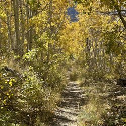
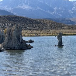
The best way to study geology is to explore the earth, and climb around on its landforms. For a lesson in volcanology, we visited Panum Crater, a textbook example of a complete plug dome volcano, located near the south shore of Mono Lake. The volcano erupted in the 14th century, and consists of a central lava dome surrounded by an intact ring of ejecta. To encouter the geology, we followed two accessible and easy trails, one circumnavigating the rim of the volcano, and the other traversing the crater and plug dome. The undulating, two-mile Rim Trail completely encircles the volcano, follows the crown of the ejecta ring, and includes a magnificent panoramic view of Mono Lake. Since the trail surface consists of loose sand- and gravel-sized rock blown out of the volcanic crater, the footing is soft and sluggish, like along the crest of a sand dune.The high point of the Rim Trail is at the north end, where a 180-degree vista of Mono Lake unfolds. The shorter Plug Trail ascends the lava dome in the center of the volcano. The lava dome consists of huge mounds of black volcanic glass (obsidian) and airy beige pumice. Much of the obsidian and pumice are banded together as the frothy pumice floated atop the rapidly cooling lava, like the foam on a pint of Guiness stout. Thirsty for knowledge, we found Panum Crater an enlightening chapter in the textbook of geologic wonders of eastern California. In my book, it gets 4 stars for its out-of-this-world scenery, birds-eye view, stimulating trails, and textbook geology.

This review is for Panum Crater Trail which was a ~2.5 miles round trip that took ~1.5 hour to complete. This was an unique hike that takes you to the rim of the crater overlooking Mono Lake as well as to the center of the crater filled with obsidian rocks! The trail was mostly sandy and a little rocky closer to the summit. The best views of Mono Lake are on the rim trail! AllTrails GPX route doesn't take you to the summit. Follow the trail for another ~0.2 miles to reach the summit for a brief view of Mono Lake. Required to drive ~0.5 miles on dirt road. Short video of the hike for those interested! https://youtu.be/VurvIs-_Cnw read more


STEPH JUDGEMENT: One of my favorite hikes in Mono County. I've been back several times now, and my appreciation for this place grows each time. And I've finally managed to remember "Bitch Hill" (a term I coined) on my last visit. For some reason I totally blocked it out from my first visit--maybe because I was trying hard not to be blown off the trail by a freak spring storm--but it's a section on the Rim Trail that's quite steep that'll definitely elevate your heart rate. I always start out with the Plug Trail to see all the rocks, and then go back down and do the Rim Trail for the views of the lake. It's not a long hike, but there is that "hill", lol. read more


3 years ago
Be ready to huff and puff! Panum Crater is next to Mono Lake right off CA-120, what used to be one of the loneliest roads in America! The crater has two main trails: the Rim Trail and the Plug Trail. The Rim Trail will make you work for it on a hot day! Take a lot of water with you. The Plug Trail is somewhat easier, and depending on the time of the day you may get some shade at stretches. Do not try any of the unofficial trail, because you could easily get lost down there or get hurt walking over glassy volcanic rubble that covers your path. Both trails provide nice views of Mono Lake, so you may want to take a camera with you. If you have your cell phone, you will get reception, although weak, at parts of the trail including the starting point at the parking lot. The crater is about 20 minutes from Lee Vining if you are driving and about 3 hours if you are hiking. But if you are hiking, save enough energy to hike the crater and then hike back! Again, it could get hot. read more


12 years ago
The best way to study geology is to explore the earth, and climb around on its landforms. For a lesson in volcanology, we visited Panum Crater, a textbook example of a complete plug dome volcano, located near the south shore of Mono Lake. The volcano erupted in the 14th century, and consists of a central lava dome surrounded by an intact ring of ejecta. To encouter the geology, we followed two accessible and easy trails, one circumnavigating the rim of the volcano, and the other traversing the crater and plug dome. The undulating, two-mile Rim Trail completely encircles the volcano, follows the crown of the ejecta ring, and includes a magnificent panoramic view of Mono Lake. Since the trail surface consists of loose sand- and gravel-sized rock blown out of the volcanic crater, the footing is soft and sluggish, like along the crest of a sand dune.The high point of the Rim Trail is at the north end, where a 180-degree vista of Mono Lake unfolds. The shorter Plug Trail ascends the lava dome in the center of the volcano. The lava dome consists of huge mounds of black volcanic glass (obsidian) and airy beige pumice. Much of the obsidian and pumice are banded together as the frothy pumice floated atop the rapidly cooling lava, like the foam on a pint of Guiness stout. Thirsty for knowledge, we found Panum Crater an enlightening chapter in the textbook of geologic wonders of eastern California. In my book, it gets 4 stars for its out-of-this-world scenery, birds-eye view, stimulating trails, and textbook geology. read more


6 years ago
This is a no-brainer visit if you're in or passing through Lee Vining. There is a longer hike and a shorter hike to the top of this crater. Plus, it's free! It's amazing to see all the different types of lava rocks including obsidian aka black glass. The views on the way up and at the top are amazing. You are hiking through Rocky send so it is a good workout but not so strenuous that your heart is pounding. read more


12 years ago
More info about Panum Crater
Ask the Community - Panum Crater


Why does Yelp recommend reviews?
1 review that is not currently recommended
The reviews below are not factored into the business's overall star rating.
9 years ago
Panum Crater - hiking - Updated June 2026
Best of Lee Vining
People found Panum Crater by searching for…
Things to Do in Lee Vining, California
Natural Hot Springs in Lee Vining, California
Gold Panning in Lee Vining, California
Snow Park in Lee Vining, California
Fishing Spots in Lee Vining, California
Playgrounds in Lee Vining, California
National Parks in Lee Vining, California
Off Road Trails in Lee Vining, California
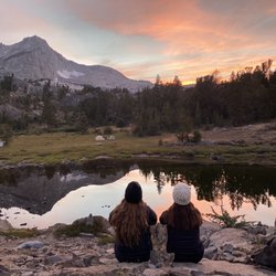
Watch Sunset in Lee Vining, California
River Swimming in Lee Vining, California
Picnic Spots in Lee Vining, California
Parks for Kids in Lee Vining, California
Free Campgrounds in Lee Vining, California
Sunrise View in Lee Vining, California
Playgrounds for Kids in Lee Vining, California
Hiking Trails in Lee Vining, California
Photo Spots in Lee Vining, California
Free Picnic Areas in Lee Vining, California
Toddler Parks in Lee Vining, California
Sculpture Garden in Lee Vining, California
Hikes With Waterfalls in Lee Vining, California
View Points in Lee Vining, California
Trending Searches in Lee Vining, CA
Cliff Jumping near Panum Crater
Dog Friendly Beaches near Panum Crater
Fishing Spots near Panum Crater
Jet Ski Rental near Panum Crater
Kayak Rental near Panum Crater
Off Road Trails near Panum Crater
Public Shower near Panum Crater
River Tubing near Panum Crater
Sunrise View near Panum Crater
Browse Articles
Browse Nearby
BEST of Lee Vining, California Things to Do near Panum Crater
BEST of Lee Vining, California Restaurants near Panum Crater
BEST of Lee Vining, California Parks near Panum Crater
BEST of Lee Vining, California Coffee near Panum Crater
BEST of Lee Vining, California Swimming Holes near Panum Crater
BEST of Lee Vining, California Hot Springs near Panum Crater
BEST of Lee Vining, California Breakfast near Panum Crater
BEST of Lee Vining, California Visitor Centers near Panum Crater
BEST of Lee Vining, California Campgrounds near Panum Crater
Browse Brands
Related Searches in Lee Vining, CA
Affordable Kayak Rental Services in Lee Vining, California
Best Fishing Locations and Guides in Lee Vining, California
Best Nature Trails for Hiking in Lee Vining, California
Best Off Leash Dog Parks in Lee Vining, California
Best Parks for Parties and Events in Lee Vining, California
Best Places for Horseback Riding in Lee Vining, California
Best Sledding Spots and Fun in Lee Vining, California
Best Water Parks for Kids in Lee Vining, California
Check Out Great Playgrounds in Lee Vining, California
Discover Dog Friendly Trails to Explore in Lee Vining, California
Discover Fun Activities to Do in Lee Vining, California
Discover Fun Toddler Parks in Lee Vining, California for Your Little One
Discover Popular Bike Trails in Lee Vining, California
Discover Popular Photo Spots in Lee Vining, California
Discover Scenic Mountain Bike Trails Near Lee Vining, California
Discover Scenic Waterfall Spots in Lee Vining, California
Discover Top Nature Parks to Visit in Lee Vining, California
Discover a Hiking Trail in Lee Vining, California
Discover the Best Night Hike Trails in Lee Vining, California
Dog-Friendly Hikes With Dogs in Lee Vining, California
Effective Stairs Workout Spots in Lee Vining, California
Enjoy Camping Adventures Around Lee Vining, California
Enjoy Kayaking Adventures in Lee Vining, California
Enjoy Tent Camping Spots Around Lee Vining, California
Enjoy the Best Tubing Experiences in Lee Vining, California
Enjoy the Best Walking Trails in Lee Vining, California
Exciting Cliff Jumping Spots in Lee Vining, California
Experience Thrilling White Water Rafting in Lee Vining, California
Explore Beautiful Parks and Green Spaces in Lee Vining, California
Explore Bike Rentals Throughout Lee Vining, California
Explore Easy Hikes Perfect for All in Lee Vining, California
Explore Free Picnic Areas Around Lee Vining, California
Explore Free Things to Do Around Lee Vining, California
Explore Fun Activities to Do in Lee Vining, California
Explore Parks With Pull Up Bars in Lee Vining, California
Explore Popular Campgrounds Near Lee Vining, California
Explore Popular Picnic Areas Around Lee Vining, California
Explore Popular RV Parks Around Lee Vining, California
Explore Scenic Lakes to Visit in Lee Vining, California
Explore Secret Spots Worth Visiting in Lee Vining, California
Explore Top Gyms in Lee Vining, California Now
Explore the Best Boating Spots in Lee Vining, California
Explore the Best Swimming Holes Around Lee Vining, California
Family Friendly Hiking With Kids in Lee Vining, California
Find Beautiful Views in Lee Vining, California
Find Picnic Tables for Outdoor Fun in Lee Vining, California
Find Popular Ziplining Spots Around Lee Vining, California
Find Top-Rated Waterfalls in Lee Vining, California Now
Find the Best Parks for Picnics in Lee Vining, California
Find the Best Swimming Pools in Lee Vining, California Today