Mono Basin Visitor Center Photos


More like Mono Basin Visitor Center
Recommended Reviews - Mono Basin Visitor Center
Start your review...

Reviews With Photos

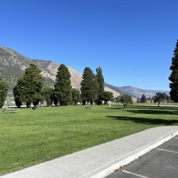
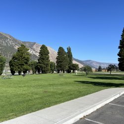
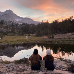
Start right here! If you are visiting the Mono lake Basin area for the first time, the Mono Basin National Forest Scenic Area Visitor Center should be one of your first stops! The Visitor Center, which opened in 1992, provides all visitors a great introduction to the Mono Basin area. There are interactive displays that teach about many aspects of the Mono Basin's geology and human history. In my two stops there, I haven't had the opportunity to watch the award-winning film "Of Ice and Fire: A Portrait of the Mono Basin", but I am told it is only 20 minutes long and gives an excellent introduction to Mono Lake. There is a bookstore that is operated by the Eastern Sierra Interpretive Association (ESIA) that offers a comprehensive selection of books and maps of the region. I was told that the revenue from sales of these items goes towards supporting the interpretative programs offered at the center. There are also two galleries, one is the "At Mono Lake" photo exhibit and there other one is a changing art exhibit. The rangers who are present all day can answer your questions. In my two visits I have got a wealth of information by speaking to the rangers who helped me with everything from best spots for photographing the Mono Lake at different times of the day to the conditions of the roads in the area. If you walk through and make it to the back of the building, you will have a stunning view of Mono Lake. There are trails that start around the building and lead you to the lake.


8 months ago
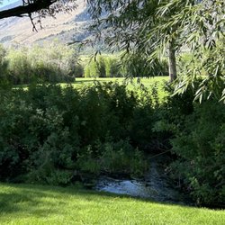
Mono Basin is such a beautiful and unique area to explore. There's an easy walking path that takes you right to the lake, making it accessible and enjoyable. Along the way, you'll see fascinating volcanic rock formations and helpful signs that describe the surrounding vegetation, which really adds to the experience. Peaceful, scenic, and educational--a great stop for anyone visiting the area! read more


Start right here! If you are visiting the Mono lake Basin area for the first time, the Mono Basin National Forest Scenic Area Visitor Center should be one of your first stops! The Visitor Center, which opened in 1992, provides all visitors a great introduction to the Mono Basin area. There are interactive displays that teach about many aspects of the Mono Basin's geology and human history. In my two stops there, I haven't had the opportunity to watch the award-winning film "Of Ice and Fire: A Portrait of the Mono Basin", but I am told it is only 20 minutes long and gives an excellent introduction to Mono Lake. There is a bookstore that is operated by the Eastern Sierra Interpretive Association (ESIA) that offers a comprehensive selection of books and maps of the region. I was told that the revenue from sales of these items goes towards supporting the interpretative programs offered at the center. There are also two galleries, one is the "At Mono Lake" photo exhibit and there other one is a changing art exhibit. The rangers who are present all day can answer your questions. In my two visits I have got a wealth of information by speaking to the rangers who helped me with everything from best spots for photographing the Mono Lake at different times of the day to the conditions of the roads in the area. If you walk through and make it to the back of the building, you will have a stunning view of Mono Lake. There are trails that start around the building and lead you to the lake. read more


5 years ago
My family and I visited the visitor center on a Saturday morning in June. The rangers was at the desk seemed helpful. The exhibit was interesting too. Then we got to see the mono lake through the back of visitor center. The restrooms was opened and flushing. Parking was available. read more

4 years ago
7 years ago
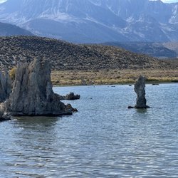
Mono Basin Visitor Center gives a beautiful view of Mono Lake as well as the mountains. While doing a scenic drive, it's worth stopping by to soak in the view. The visitor center was closed when we arrived but the view is always available. read more


7 years ago
More info about Mono Basin Visitor Center
1 Visitor Center Dr
Lee Vining, CA 93541
Directions
(760) 647-3044
Call Now
Hours
Outdoor Amenities
Ask the Community - Mono Basin Visitor Center


Mono Basin Visitor Center - parks - Updated July 2026
Best of Lee Vining
People found Mono Basin Visitor Center by searching for…
Swimming Holes in Lee Vining, CA
Visitor Centers in Lee Vining, CA
Natural Hot Springs in Lee Vining, CA
Things to Do in Lee Vining, CA
Scenic Drive in Lee Vining, CA
Beautiful Views in Lee Vining, CA
Lookout Points in Lee Vining, CA
Dog Swimming in Lee Vining, CA
Public Shower in Lee Vining, CA
Picnic Spots in Lee Vining, CA
Fishing Ponds in Lee Vining, CA
Restaurant With a View in Lee Vining, CA
Nature Parks in Lee Vining, CA
National Parks in Lee Vining, CA
Trending Searches in Lee Vining, CA
Boat Rental near Mono Basin Visitor Center
Cliff Jumping near Mono Basin Visitor Center
Dog Friendly Beaches near Mono Basin Visitor Center
Fishing Spots near Mono Basin Visitor Center
Jet Ski Rental near Mono Basin Visitor Center
Kayak Rental near Mono Basin Visitor Center
Lakes near Mono Basin Visitor Center
Lookout Points near Mono Basin Visitor Center
Picnic Areas near Mono Basin Visitor Center
River Swimming near Mono Basin Visitor Center
River Tubing near Mono Basin Visitor Center
Soccer Store near Mono Basin Visitor Center
Swimming Holes near Mono Basin Visitor Center
Browse Articles
Browse Nearby
BEST of Lee Vining, California Things to Do near Mono Basin Visitor Center
BEST of Lee Vining, California Hiking near Mono Basin Visitor Center
BEST of Lee Vining, California Restaurants near Mono Basin Visitor Center
BEST of Lee Vining, California Coffee near Mono Basin Visitor Center
BEST of Lee Vining, California Picnic Areas near Mono Basin Visitor Center
BEST of Lee Vining, California Natural Hot Springs near Mono Basin Visitor Center
BEST of Lee Vining, California Breakfast near Mono Basin Visitor Center
BEST of Lee Vining, California Campgrounds near Mono Basin Visitor Center
BEST of Lee Vining, California Gold Panning near Mono Basin Visitor Center
Browse Brands
Related Searches in Lee Vining, CA
Affordable Kayak Rental Services in Lee Vining, California
Best Fishing Locations and Guides in Lee Vining, California
Best Nature Trails for Hiking in Lee Vining, California
Best Off Leash Dog Parks in Lee Vining, California
Best Parks for Parties and Events in Lee Vining, California
Best Places for Horseback Riding in Lee Vining, California
Best Sledding Spots and Fun in Lee Vining, California
Best Water Parks for Kids in Lee Vining, California
Best Waterfalls and Swimming Holes in Lee Vining, California
Check Out Great Playgrounds in Lee Vining, California
Discover Fun Activities to Do in Lee Vining, California
Discover Fun Toddler Parks in Lee Vining, California for Your Little One
Discover Lakes & Ponds to Explore in Lee Vining, California
Discover Popular Photo Spots in Lee Vining, California
Discover Top Nature Parks to Visit in Lee Vining, California
Discover the Best Fishing Lake in Lee Vining, California
Enjoy Kayaking Adventures in Lee Vining, California
Enjoy Tent Camping Spots Around Lee Vining, California
Enjoy Water Activities and Fun in Lee Vining, California
Enjoy the Best Tubing Experiences in Lee Vining, California
Enjoy the Best Walking Trails in Lee Vining, California
Experience Thrilling White Water Rafting in Lee Vining, California
Explore Beautiful Parks and Green Spaces in Lee Vining, California
Explore Bike Rentals Throughout Lee Vining, California
Explore Free Picnic Areas Around Lee Vining, California
Explore Free Things to Do Around Lee Vining, California
Explore Fun Activities to Do in Lee Vining, California
Explore Parks With Pull Up Bars in Lee Vining, California
Explore Popular Campgrounds Near Lee Vining, California
Explore Popular Picnic Areas Around Lee Vining, California
Explore Popular RV Parks Around Lee Vining, California
Explore Scenic Lakes to Visit in Lee Vining, California
Explore Secret Spots Worth Visiting in Lee Vining, California
Explore Top Gyms in Lee Vining, California Now
Explore the Best Boating Spots in Lee Vining, California
Explore the Best Swimming Holes Around Lee Vining, California
Explore the Scenic River in Lee Vining, California
Find Beautiful Views in Lee Vining, California
Find Picnic Tables for Outdoor Fun in Lee Vining, California
Find Top Dog Swimming Spots in Lee Vining, California
Find Top-Rated Waterfalls in Lee Vining, California Now
Find the Best Parks for Picnics in Lee Vining, California
Find the Best Playgrounds to Visit in Lee Vining, California
Find the Best Swimming Pools in Lee Vining, California Today
Fun Indoor Activities to Try in Lee Vining, California
Great Places to Swim in Lee Vining, California
Have Fun at a Splash Pad in Lee Vining, California
Locate a Public Shower Facility in Lee Vining, California
Must-See Tourist Attractions Around Lee Vining, California
Parks With Basketball Courts for Games in Lee Vining, California