Seaview Trail At Inspiration Point Photos


You might also consider
More like Seaview Trail At Inspiration Point
Recommended Reviews - Seaview Trail At Inspiration Point
Start your review...

Reviews With Photos

This was a nice hour and a half hike. Parking was easy and right by the steam trains. You have views of the bay and contra costa. The weather was great today and I was surprised at how empty the trails were. There are some steep spots but it wasn't a difficult hike. There were families and people of all ages. It's mostly a pavement trail so your shoes won't get too dirty. Just watch for some bikers who go through the trails as well. It's dog friendly and you can also go on the train with dogs who are socialized!

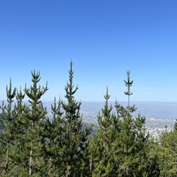
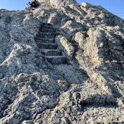
I'm not a real hiker. I just play one on TV. OK, I'm not on TV but I do have a Netflix subscription. That's neither here nor there, but this rustic trail is definitely over there. If you find the Nimitz Trail too crowded and coddled, you will likely find this one more appealing even if loose gravel will likely make you lose your footing. Like I said, I'm not a real hiker, so I shriek like a little girl when I find myself tumbling to the ground. Not that I did that. Much. If you start at the trailhead off Wildcat Canyon Road, the path starts on a gradual climb (photo: http://bit.ly/2uLENQx). This section is next to open meadows with views of the surrounding conifer-covered hills (photo: http://bit.ly/2JPrUtH). It gets rockier as you approach the crest of the hill, and you're actually in a grove of trees and bushes until finally you reach the top where you can see the bay to the west and the rolling East Bay hills on the other side (photo: http://bit.ly/2JNyL6Q). There are benches to take it in and even a meditation circle (photo: http://bit.ly/2OcYclJ). The trail beyond is mostly bucolic with lots of pines amid the rolling elevation of the trail. I rarely passed by either hikers or bikers, which made it feel a whole lot more exclusive. RELATED - Up for a hike? Here are the places around the Bay Area where I have trodded: http://bit.ly/2OsCCsK

Typing in "Seaview Trailhead" into my GPS got me to a small parking lot with a single porta-potty near the trail entrance. I didn't see any signs about parking fees, so I'm pretty sure it was free. I came during the summer, so the hike was overall very sunny, hot, and dry. There are trees in the area, but they don't do a good job of providing shade, so bringing a hat and plenty of water is a good idea. The trail isn't insanely steep, but there's still some incline and you'll definitely get a good sweat out of it. I like how this trail is only a short drive away from major city life, so it has good cell reception, and once you're done with the hike, you can grab food at one of the many amazing eateries in Berkeley.

Awesome 3.5 mile hike with incredible views all around. Went on a clear day and saw everything from SF, the Bay, Alcatraz, Golden Gate Bridge, Oakland to the San Pablo Reservoir. Parked at the Quarry Picnic lot. Seaview Trail - Upper Big Springs Trail -Lower Big Springs Trail - Quarry Trail

If I would have rated this trail during the fall or winter, I would have given it a 5 star. Seaview trail could be accessed thru many routes but all are off of Wildcat Canyon Rd or S. Park Rd. You can take Arroyo, Lower Spring Trail or Quarry Ln. Not sure why you would park at Inspiration point to cross a 2 lane road but it would be your choice. Pros: Less busier than Inspiration point (which is paved) Better cardio (elevation from Quarry Ln to the top of Seaview is around 990 Ft. Gorgeous views of Bay Bridge, SF, GG bridge and Richmond Bridge Since you are walking on top of the hill, you also get a great view of rolling hills, San Pablo and Briones reservoir Cons: This only applies to sunny and warm days because most of the hike you are exposed to the sun and once in a while you get a shady spot that is probably around 10-20 degrees cooler than sunny part! DON'T FORGET a good cap (if you have something that also covers the back of your neck it would be even better), water, sunscreen. Camera is optional but you won't regret it!

Seaview Trail is just one of many hiking/biking/horse trails that can be found at Inspiration Point in Tilden Regional Park. The trail reviewed here links with several other trails to create a six-mile loop that can be hiked in two hours, not including stops. With all the scenery to be enjoyed here, you might want to add an extra hour or more for your hike. We chose Seaview because we wanted to explore the area north of Claremont Canyon. On this warm fall day, we also decided to avoid the wide, paved (and sun-exposed) Nimitz Way that's more traveled and used by families with strollers and the like. We left our car at the Inspiration Point parking lot. The posted trail maps show both mileage markers and topo, so you can choose the type of hike best suited for you. Seaview trail is a combination of fire road, fire trail and footpaths winding along the ridges and arroyos of Tilden Park. Scenic views from the ridge include much of the bay area, north bay and over the hill to Briones and San Pablo reservoirs. We liked it! Our six mile hike was as follows: Trailhead is to the left of the Nimitz Way pillars. The trail starts downhill, then up and across Wildcat Canyon Road where it becomes a fire road, climbing through meadows, stands of eucalyptus, pine and oak with views along the way. We walked mostly along the ridge for nearly two miles before descending Arroyo Trail to head back. Route: Seaview Trail to East Bay National Trail, to Bay Area Ridge Trail, to the intersection of Arroyo Trail (halfway point). Down Arroyo Trail to South Park Drive (paved road). Continue west on Quarry Trail and find your way back to Seaview Trail, then back to your car. Some of the dozens of other trails will be reviewed here at some point! Enjoy a well-earned meal in nearby Berkeley when you're done. We caught the Sunday Streets event along Shattuck, and stopped in at Sliver Pizzeria for a delectable slice, chased down with pints of Lagunitas Hop Stoopid and Deschutes Fresh Squeezed IPA. What. Are you waiting for. The roundup: Distance: 6 mile loop Time: 2 hours plus view-ogling time (allow 3-4 hours total) Difficulty: You can do this holding a martini, but there are some steep spots. Highlights: Eucalyptus groves, views of SF, bridges, the entire north bay. Sucks: Really, nothing. It's great, don't get poison oak! Water: 1 liter per person. Dogs: Allowed!

11 months ago
A pretty awesome workout at this trail. We did about six miles in a little bit over two hours (1300 elevation). There were mixed shades and sun. There were some rocky paths here and there. Overall it's a moderate and enjoyable hike with some great views along the way. read more
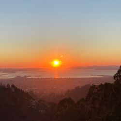
I am smitten. Been hiking all up, down, and around Tilden Park lately, and I have to admit that this is definitely one of Tilden's most gorgeous trails! Probably like top 3 in my book. It's also one of the most crowded hiking trails, but it makes sense. That still shouldn't stop you from visiting (even during the pandemic). I've hiked this trail from the entrance of Inspiration point and from the entrance of the Steam Trains, and both ways are absolutely stunning. But, I would definitely recommend the entrance from Inspiration Point if it's your first time. You'll get the best views this way. You can do an out and back on this trail or you can turn it into a loop by connect to the Big Springs Trail. I did the loops and it was about 6 miles round trip. The trail itself isn't difficult but it's filled with lots of gradual inclines. The main pathway is wide and paved. Many families with strollers use this trail. The Sea View Trail meanders through tall Redwood groves and lush meadows. It's also filled with so many amazingly colorful wildflowers! Probably the most that I've seen on a trail that wasn't centered around flowers. Lots of wildlife is present. The surrounding views of the Briones and San Pablo Reservoir are truly breathtaking! Couple that with the stunning views of San Francisco and its' iconic landmarks, and you'll be in for a real treat. This trail exposes the true beauty of the Bay Area. What I love about this trail is that it stays lush and green all year around. But you just can't beat the bright blue skies and charming spring and summer sunsets. This trail is also very dog friendly for those with furry friends. It's so easy to connect to several other trails within Tilden Park from Sea View, but you may not want to venture off from this trail at first because it's just that beautiful. read more


1 year ago
This was a nice hour and a half hike. Parking was easy and right by the steam trains. You have views of the bay and contra costa. The weather was great today and I was surprised at how empty the trails were. There are some steep spots but it wasn't a difficult hike. There were families and people of all ages. It's mostly a pavement trail so your shoes won't get too dirty. Just watch for some bikers who go through the trails as well. It's dog friendly and you can also go on the train with dogs who are socialized! read more
I'm not a real hiker. I just play one on TV. OK, I'm not on TV but I do have a Netflix subscription. That's neither here nor there, but this rustic trail is definitely over there. If you find the Nimitz Trail too crowded and coddled, you will likely find this one more appealing even if loose gravel will likely make you lose your footing. Like I said, I'm not a real hiker, so I shriek like a little girl when I find myself tumbling to the ground. Not that I did that. Much. If you start at the trailhead off Wildcat Canyon Road, the path starts on a gradual climb (photo: http://bit.ly/2uLENQx). This section is next to open meadows with views of the surrounding conifer-covered hills (photo: http://bit.ly/2JPrUtH). It gets rockier as you approach the crest of the hill, and you're actually in a grove of trees and bushes until finally you reach the top where you can see the bay to the west and the rolling East Bay hills on the other side (photo: http://bit.ly/2JNyL6Q). There are benches to take it in and even a meditation circle (photo: http://bit.ly/2OcYclJ). The trail beyond is mostly bucolic with lots of pines amid the rolling elevation of the trail. I rarely passed by either hikers or bikers, which made it feel a whole lot more exclusive. RELATED - Up for a hike? Here are the places around the Bay Area where I have trodded: http://bit.ly/2OsCCsK read more


3 years ago
3 years ago
Typing in "Seaview Trailhead" into my GPS got me to a small parking lot with a single porta-potty near the trail entrance. I didn't see any signs about parking fees, so I'm pretty sure it was free. I came during the summer, so the hike was overall very sunny, hot, and dry. There are trees in the area, but they don't do a good job of providing shade, so bringing a hat and plenty of water is a good idea. The trail isn't insanely steep, but there's still some incline and you'll definitely get a good sweat out of it. I like how this trail is only a short drive away from major city life, so it has good cell reception, and once you're done with the hike, you can grab food at one of the many amazing eateries in Berkeley. read more


Awesome 3.5 mile hike with incredible views all around. Went on a clear day and saw everything from SF, the Bay, Alcatraz, Golden Gate Bridge, Oakland to the San Pablo Reservoir. Parked at the Quarry Picnic lot. Seaview Trail - Upper Big Springs Trail -Lower Big Springs Trail - Quarry Trail read more


If I would have rated this trail during the fall or winter, I would have given it a 5 star. Seaview trail could be accessed thru many routes but all are off of Wildcat Canyon Rd or S. Park Rd. You can take Arroyo, Lower Spring Trail or Quarry Ln. Not sure why you would park at Inspiration point to cross a 2 lane road but it would be your choice. Pros: Less busier than Inspiration point (which is paved) Better cardio (elevation from Quarry Ln to the top of Seaview is around 990 Ft. Gorgeous views of Bay Bridge, SF, GG bridge and Richmond Bridge Since you are walking on top of the hill, you also get a great view of rolling hills, San Pablo and Briones reservoir Cons: This only applies to sunny and warm days because most of the hike you are exposed to the sun and once in a while you get a shady spot that is probably around 10-20 degrees cooler than sunny part! DON'T FORGET a good cap (if you have something that also covers the back of your neck it would be even better), water, sunscreen. Camera is optional but you won't regret it! read more


 - Hiking Near Me - Berkeley, California")

Seaview Trail is just one of many hiking/biking/horse trails that can be found at Inspiration Point in Tilden Regional Park. The trail reviewed here links with several other trails to create a six-mile loop that can be hiked in two hours, not including stops. With all the scenery to be enjoyed here, you might want to add an extra hour or more for your hike. We chose Seaview because we wanted to explore the area north of Claremont Canyon. On this warm fall day, we also decided to avoid the wide, paved (and sun-exposed) Nimitz Way that's more traveled and used by families with strollers and the like. We left our car at the Inspiration Point parking lot. The posted trail maps show both mileage markers and topo, so you can choose the type of hike best suited for you. Seaview trail is a combination of fire road, fire trail and footpaths winding along the ridges and arroyos of Tilden Park. Scenic views from the ridge include much of the bay area, north bay and over the hill to Briones and San Pablo reservoirs. We liked it! Our six mile hike was as follows: Trailhead is to the left of the Nimitz Way pillars. The trail starts downhill, then up and across Wildcat Canyon Road where it becomes a fire road, climbing through meadows, stands of eucalyptus, pine and oak with views along the way. We walked mostly along the ridge for nearly two miles before descending Arroyo Trail to head back. Route: Seaview Trail to East Bay National Trail, to Bay Area Ridge Trail, to the intersection of Arroyo Trail (halfway point). Down Arroyo Trail to South Park Drive (paved road). Continue west on Quarry Trail and find your way back to Seaview Trail, then back to your car. Some of the dozens of other trails will be reviewed here at some point! Enjoy a well-earned meal in nearby Berkeley when you're done. We caught the Sunday Streets event along Shattuck, and stopped in at Sliver Pizzeria for a delectable slice, chased down with pints of Lagunitas Hop Stoopid and Deschutes Fresh Squeezed IPA. What. Are you waiting for. The roundup: Distance: 6 mile loop Time: 2 hours plus view-ogling time (allow 3-4 hours total) Difficulty: You can do this holding a martini, but there are some steep spots. Highlights: Eucalyptus groves, views of SF, bridges, the entire north bay. Sucks: Really, nothing. It's great, don't get poison oak! Water: 1 liter per person. Dogs: Allowed! read more


6 years ago
8 years ago
10 years ago
More info about Seaview Trail At Inspiration Point
Seaview Trail
Berkeley, CA 94704
Directions
Hours
Indoor Amenities
Outdoor Amenities
Ask the Community - Seaview Trail At Inspiration Point
Review Highlights - Seaview Trail At Inspiration Point
You might also consider


Seaview Trail At Inspiration Point - hiking - Updated July 2026
Best of Berkeley
People found Seaview Trail At Inspiration Point by searching for…
Trending Searches in Berkeley, CA
Black Owned Nail Salons near Seaview Trail At Inspiration Point
Boat Rental near Seaview Trail At Inspiration Point
Cliff Jumping near Seaview Trail At Inspiration Point
Day Trips near Seaview Trail At Inspiration Point
Dog Swimming near Seaview Trail At Inspiration Point
Jet Ski Rental near Seaview Trail At Inspiration Point
Kayak Rental near Seaview Trail At Inspiration Point
Lakes & Ponds near Seaview Trail At Inspiration Point
Off Road Trails near Seaview Trail At Inspiration Point
Outdoor Activities near Seaview Trail At Inspiration Point
Picnic Spots near Seaview Trail At Inspiration Point
Places To Walk Around near Seaview Trail At Inspiration Point
Public Pools near Seaview Trail At Inspiration Point
Public Shower near Seaview Trail At Inspiration Point
River Swimming near Seaview Trail At Inspiration Point
River Tubing near Seaview Trail At Inspiration Point
Rock Quarry near Seaview Trail At Inspiration Point
Running Trails near Seaview Trail At Inspiration Point
Scenic Night View near Seaview Trail At Inspiration Point
Scenic Overlook near Seaview Trail At Inspiration Point
Soccer Store near Seaview Trail At Inspiration Point
Splash Pad near Seaview Trail At Inspiration Point
Sunrise View near Seaview Trail At Inspiration Point
Swimming Holes near Seaview Trail At Inspiration Point
Swimming Lakes near Seaview Trail At Inspiration Point
U Pick Farms near Seaview Trail At Inspiration Point
Watch Sunset near Seaview Trail At Inspiration Point
Browse Articles
Browse Nearby
BEST of Berkeley, California Coffee near Seaview Trail At Inspiration Point
BEST of Berkeley, California Things to Do near Seaview Trail At Inspiration Point
BEST of Berkeley, California Restaurants near Seaview Trail At Inspiration Point
BEST of Berkeley, California Walking Trails near Seaview Trail At Inspiration Point
BEST of Berkeley, California Parks near Seaview Trail At Inspiration Point
BEST of Berkeley, California Breakfast near Seaview Trail At Inspiration Point
BEST of Berkeley, California Hot Springs near Seaview Trail At Inspiration Point
BEST of Berkeley, California Campgrounds near Seaview Trail At Inspiration Point
Browse Brands
Related Searches in Berkeley, CA
Affordable Kayak Rental Services in Berkeley, California
Best Fishing Locations and Guides in Berkeley, California
Best Nature Trails for Hiking in Berkeley, California
Best Places for Horseback Riding in Berkeley, California
Check Out Off Road Trails in Berkeley, California
Discover Dog Friendly Trails to Explore in Berkeley, California
Discover Kid Friendly Hiking Trails in Berkeley, California
Discover Scenic Hiking Trails in Berkeley, California
Discover Scenic Mountain Bike Trails Near Berkeley, California
Discover Scenic Waterfall Spots in Berkeley, California
Discover Walking Parks in Berkeley, California Near You
Discover a Hiking Trail in Berkeley, California
Discover the Best Night Hike Trails in Berkeley, California
Discover the Best Running Track in Berkeley, California
Dog-Friendly Hikes With Dogs in Berkeley, California
Enjoy Camping Adventures Around Berkeley, California
Enjoy Kayaking Adventures in Berkeley, California
Enjoy Tent Camping Spots Around Berkeley, California
Enjoy a Beautiful Waterfall Hike in Berkeley, California
Enjoy a Peaceful Nature Walk in Berkeley, California
Enjoy the Best Picnic Spots and Ideas in Berkeley, California
Enjoy the Best Walking Path in Berkeley, California
Enjoy the Best Walking Trails in Berkeley, California
Explore Beautiful Parks and Green Spaces in Berkeley, California
Explore Easy Hikes Perfect for All in Berkeley, California
Explore Fun Activities to Do in Berkeley, California
Explore Popular Campgrounds Near Berkeley, California
Explore the Best Beach Spots in Berkeley, California
Explore the Best Swimming Holes Around Berkeley, California
Explore the Best Trail Options in Berkeley, California
Family Friendly Hiking With Kids in Berkeley, California
Find Beautiful Views in Berkeley, California
Find the Best Parks for Picnics in Berkeley, California
Find the Best Scenic View Locations in Berkeley, California
Great Places to Walk in Berkeley, California
Hike the Popular Waterfall Trail in Berkeley, California
Hiking Trails With Waterfalls in Berkeley, California
Off Leash Dog Hiking Trails in Berkeley, California
Plan a Scenic Drive Route Near Berkeley, California
Popular Outdoor Activities to Try in Berkeley, California
Popular Picnic Spots to Visit in Berkeley, California
Safe River Swimming Areas in Berkeley, California
Safe and Fun Parks for Kids in Berkeley, California
Top Climbing Spots and Gyms in Berkeley, California
Top Paddleboarding Activities in Berkeley, California
Top Running Trails to Explore in Berkeley, California
Top Swimming Lakes to Enjoy in Berkeley, California
Top Swimming Spots and Pools in Berkeley, California
People who viewed Seaview Trail At Inspiration Point also viewed
Berkeley Fire Trails
110 reviews
Oakland Hills
Seaview Trail
2 reviews
Cesar Chavez Park
186 reviews
West Berkeley
Indian Rock Park
237 reviews
Berkeley Hills
Grizzly Peak
143 reviews
Oakland Hills
Marina Park
58 reviews
Mt Diablo Summit
88 reviews
Mount Diablo's Grand Loop
6 reviews
Albany Waterfront Trail
2 reviews
Skyline Trail
2 reviews