Berkeley Fire Trails Photos


You might also consider
More like Berkeley Fire Trails
Recommended Reviews - Berkeley Fire Trails
Start your review...

Reviews With Photos
This trail is a hidden gem. It's a nice relaxing stroll that honestly has one of the best views of the bay. One to two parts of the trail have steep inclines, but the rest is pretty flat. Because you drive uphill to reach the starting point of the trail (which there are many) you already start with some elevation to begin with. Also it was a nice gesture that some residents who live on the trail (there are houses that are close to the trail) provide dog treats, poop bags, and water. I will be back again!

For my 200th review, I'm finally reviewing a hike that was & is near and dear to me during my 4 years at Cal. When I didn't go to Lake Merritt, I found myself doing this hike to get some fresh air and to have a clearer mind. This hike is pretty steep during some parts so not exactly the most family friendly (for children and the elderly). The fire trails is huge, so you absolutely can go any way you like. The uniqueness of this hike is that you'll see the beautiful cities of Oakland, Berkeley, San Francisco and also be encapsulated by the forest and a serene quietness when you're up higher in elevation. There are beautiful spots to pause and sit on benches too! I recommend this hike to anyone in the area that wants something relatively challenging (especially for runners this is awesome for the strength + endurance)!


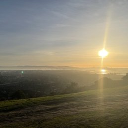
Finding parking here was quiet difficult for me. I drove around in circles for a good 30 minutes. On the way however there were some very beautiful views of the bay. You can park on the side of the road to stop and take pictures and watch the sunset. There was a good crowd of people (20 plus) at each view point.

My love for Berkeley runs far and wide. The Berkeley Fire Trails are just another reason to add to my obsession with this wonderful little city! I had hiked a few of these trails before I even knew that these were Berkeley Fire Trails. One of my other favorite hiking trails is Claremont Canyon, and I recently learned that these two trails actually connect. Furthermore, the Berkeley Fire Trails can be taken all the way to the backside of Tilden Park! Yep yep, there's a lot of exploring to do here! What I love most about these trails is the vast variety that it offers. The main trail is paved and can be accessed from behind UC Berkeley's Space Sciences Lab or between Strawberry Canyon and the UC Botanical garden right off of Centennial Drive. The main paved trail is flat throughout and measures about 3.5 miles one way. This section of the trail is great for walking and running! Many locals and UC Berkeley students frequent this trail. There are a few other trails that are a bit more challenging and offer great inclines and pretty views of lush greenery! These trails are my absolute favorite! You can veer off onto these trails from the main trail, and they can also be accessed from several different points off of Claremont Ave. You'll see big white signs with numbers and cars parked on the side of the road. At each trail entrance, there's a large blue sign that reads "Fire Trail", so it makes it pretty easy to find. The trails seem to be endless and it will make you want to explore forever. Just be sure to retrace your steps because you could end up on a whole different trail. There are trail maps located at each major entry point, and all of the entry points are labeled with a white sign that has a number. If you hike high enough, you'll be exposed to some of the most gorgeous views of the Bay! There are just too many trails for one to ever get bored here! If you're looking for fun and explorative trails that are far less traveled, I would highly recommend coming here.

Oh, hello gorgeous greenery!! It can be hard to find the entrance to this unmarked trail, so check out the attached photos of the parking lot and trailhead! The parking lot is smack dab between Strawberry canyon pool and the UC Berkeley botanical garden, and is just a little gravel patch. The No Parking signs don't refer to the entire lot, just particular spots. It's actually an ecological reserve, and parking is most certainly allowed. Parking isn't bad on weekdays, and sometimes there are even a few spots in the shade. There are two trails that start here, the upper fire trail and lower, and they register on Google if you get lost. The upper trail is partial shade, and has a gentle incline for the first mile until it pops you out onto Panoramic Dr. The views from here, despite not being the summit, are beautiful. From here you can either head back down the trail, walk down Panoramic, or head up a steep incline, where the trail continues (doooooo iiiiiiiit!!!!) I found a beehive (photo), Sharp Shinned Hawk (no photo, too fast), friendly dogs (didn't photograph, too busy petting), and a giraffe (yes, really. See photo!)

awesome trail that will give you a great workout and an AMAZING view once you get to the top. Trust me...the hard work will be worth it once you lay your eyes on the beautiful bay area skyline! The 7 mile trail has some steady gradual inclines with a few steep inclines. Wear a hat especially if you plan to hike this in the heat and make sure you bring plenty of water! It didn't take us more than 2.5 hrs round trip, with quite a few pit stops to enjoy the view! ;) Great hike in the heart of the east bay. Who says you have to travel far for a great hike?

A hike on the easier side- this one has one super steep hill that makes you think about the houses along the incline- "how do they bring groceries back?" However, most of the trail is flat- and I guess it's because you drive up a mountain to get there. Very small parking area by Strawberry Creek Rec Center- disregard the "no parking" sign- pretty ridiculous. Tips: To avoid some of the incline- you can go up the stairs by Lawrence Hall straight up to the Math Research building. You make up for the hills in stairs but at least you can walk downhill for most of the trail. Otherwise, you better stretch yo glutes! Beware bikers and pedestrians as you make your way via your vehicle towards the trail- narrow roadways. Wear layers- I swear, I alternated between hot and cold so many times!

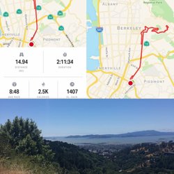
I stumbled upon these firebreaks when I was in college, and as many times as I've hiked it with friends or enjoyed a solo run, each experience makes me feel thankful for living in this part of the Bay Area. Beautiful hike. Just goes and goes. I suppose I could look up on a map to find the exact schematics, but I have ran for two hours straight with no end in sight. Best place to go for sunsets. It gets pretty chilly after 5 o'clock in the spring or winter. It's fairly littered with people, but not crowded at all. Lots of friendly people in small groups just minding their business and saying hi to each other :-) The best part of the hike/run is about a mile past the 60° angle (beast of a) hill. There is a bench made out of an old tree where the view overlooks San Francisco, Richmond, Emeryville, and a very distant Palo Alto. Beautiful. In the summer there are lots of wild raspberries, every once in a while you'll even see wild turkeys and deer! Great place

Brought my dogs here on Thursday in the morning. Not too crowded. Found a good parking spot just next to the trailhead. Half of the trail is shaded and half of it are not. But overall, this trail is awesome. not muddy. at the beginning, there's a little bit elevation gain, but afterwards, it's all flat. The only con is that it's not a round-loop trail. Once you get to the destination, there's nothing too much to see and you have to go back via the same path. A little bit boring.

I loved LOVED this trail! It's kinda hard to find! If you're coming down centennial, pass the botanical garden and park in the gravel parking lot you'll see shortly after the garden on your LEFT. The hike is wonderful! A lot of shade and some really gnarly hills. Bring water! The view at the top is breathtaking!

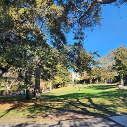
The fire trails run all over the Berkeley Hills. One entrance is on Centennial Drive, just east of Memorial Stadium. The trails are wide and the grade is pretty even, though gets very steep at points. There are lots of side trails, and beautiful views of the entire bay if you climb high enough. This is a great place to take your dog off-leash. It's also a good place for running, so I'm told. You might see wild turkeys wandering about if you're lucky. Beware of mountain lions and poison oak.

I took the dogs. I am looking after to this fire trail and they loved it. Early morning we encountered just a handful of people. Around 7 AM or so. Beautiful eucalyptus trees, cross Bay views of San Francisco and the bay bridge. And an amazing canyon that you are hiking along the side of. There are a few areas that you can connect to other parts of the trail system. I found an amazing offshoot that was super green even though it's summer time. I would highly recommend checking this place out! read more


This trail is a hidden gem. It's a nice relaxing stroll that honestly has one of the best views of the bay. One to two parts of the trail have steep inclines, but the rest is pretty flat. Because you drive uphill to reach the starting point of the trail (which there are many) you already start with some elevation to begin with. Also it was a nice gesture that some residents who live on the trail (there are houses that are close to the trail) provide dog treats, poop bags, and water. I will be back again! read more


For my 200th review, I'm finally reviewing a hike that was & is near and dear to me during my 4 years at Cal. When I didn't go to Lake Merritt, I found myself doing this hike to get some fresh air and to have a clearer mind. This hike is pretty steep during some parts so not exactly the most family friendly (for children and the elderly). The fire trails is huge, so you absolutely can go any way you like. The uniqueness of this hike is that you'll see the beautiful cities of Oakland, Berkeley, San Francisco and also be encapsulated by the forest and a serene quietness when you're up higher in elevation. There are beautiful spots to pause and sit on benches too! I recommend this hike to anyone in the area that wants something relatively challenging (especially for runners this is awesome for the strength + endurance)! read more


Great network of trails that I want to come back and explore! we did the Stonewall-Panoramic Trail, which we thought was only 1.5 miles, but turns out you can extend it way longer. We will do that in the future. Views were really nice and parking is pretty easy in the neighborhood. read more


Finding parking here was quiet difficult for me. I drove around in circles for a good 30 minutes. On the way however there were some very beautiful views of the bay. You can park on the side of the road to stop and take pictures and watch the sunset. There was a good crowd of people (20 plus) at each view point. read more


My love for Berkeley runs far and wide. The Berkeley Fire Trails are just another reason to add to my obsession with this wonderful little city! I had hiked a few of these trails before I even knew that these were Berkeley Fire Trails. One of my other favorite hiking trails is Claremont Canyon, and I recently learned that these two trails actually connect. Furthermore, the Berkeley Fire Trails can be taken all the way to the backside of Tilden Park! Yep yep, there's a lot of exploring to do here! What I love most about these trails is the vast variety that it offers. The main trail is paved and can be accessed from behind UC Berkeley's Space Sciences Lab or between Strawberry Canyon and the UC Botanical garden right off of Centennial Drive. The main paved trail is flat throughout and measures about 3.5 miles one way. This section of the trail is great for walking and running! Many locals and UC Berkeley students frequent this trail. There are a few other trails that are a bit more challenging and offer great inclines and pretty views of lush greenery! These trails are my absolute favorite! You can veer off onto these trails from the main trail, and they can also be accessed from several different points off of Claremont Ave. You'll see big white signs with numbers and cars parked on the side of the road. At each trail entrance, there's a large blue sign that reads "Fire Trail", so it makes it pretty easy to find. The trails seem to be endless and it will make you want to explore forever. Just be sure to retrace your steps because you could end up on a whole different trail. There are trail maps located at each major entry point, and all of the entry points are labeled with a white sign that has a number. If you hike high enough, you'll be exposed to some of the most gorgeous views of the Bay! There are just too many trails for one to ever get bored here! If you're looking for fun and explorative trails that are far less traveled, I would highly recommend coming here. read more


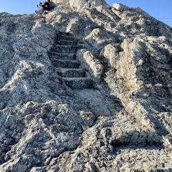
Oh, hello gorgeous greenery!! It can be hard to find the entrance to this unmarked trail, so check out the attached photos of the parking lot and trailhead! The parking lot is smack dab between Strawberry canyon pool and the UC Berkeley botanical garden, and is just a little gravel patch. The No Parking signs don't refer to the entire lot, just particular spots. It's actually an ecological reserve, and parking is most certainly allowed. Parking isn't bad on weekdays, and sometimes there are even a few spots in the shade. There are two trails that start here, the upper fire trail and lower, and they register on Google if you get lost. The upper trail is partial shade, and has a gentle incline for the first mile until it pops you out onto Panoramic Dr. The views from here, despite not being the summit, are beautiful. From here you can either head back down the trail, walk down Panoramic, or head up a steep incline, where the trail continues (doooooo iiiiiiiit!!!!) I found a beehive (photo), Sharp Shinned Hawk (no photo, too fast), friendly dogs (didn't photograph, too busy petting), and a giraffe (yes, really. See photo!) read more


awesome trail that will give you a great workout and an AMAZING view once you get to the top. Trust me...the hard work will be worth it once you lay your eyes on the beautiful bay area skyline! The 7 mile trail has some steady gradual inclines with a few steep inclines. Wear a hat especially if you plan to hike this in the heat and make sure you bring plenty of water! It didn't take us more than 2.5 hrs round trip, with quite a few pit stops to enjoy the view! ;) Great hike in the heart of the east bay. Who says you have to travel far for a great hike? read more


A hike on the easier side- this one has one super steep hill that makes you think about the houses along the incline- "how do they bring groceries back?" However, most of the trail is flat- and I guess it's because you drive up a mountain to get there. Very small parking area by Strawberry Creek Rec Center- disregard the "no parking" sign- pretty ridiculous. Tips: To avoid some of the incline- you can go up the stairs by Lawrence Hall straight up to the Math Research building. You make up for the hills in stairs but at least you can walk downhill for most of the trail. Otherwise, you better stretch yo glutes! Beware bikers and pedestrians as you make your way via your vehicle towards the trail- narrow roadways. Wear layers- I swear, I alternated between hot and cold so many times! read more


9 years ago
I stumbled upon these firebreaks when I was in college, and as many times as I've hiked it with friends or enjoyed a solo run, each experience makes me feel thankful for living in this part of the Bay Area. Beautiful hike. Just goes and goes. I suppose I could look up on a map to find the exact schematics, but I have ran for two hours straight with no end in sight. Best place to go for sunsets. It gets pretty chilly after 5 o'clock in the spring or winter. It's fairly littered with people, but not crowded at all. Lots of friendly people in small groups just minding their business and saying hi to each other :-) The best part of the hike/run is about a mile past the 60° angle (beast of a) hill. There is a bench made out of an old tree where the view overlooks San Francisco, Richmond, Emeryville, and a very distant Palo Alto. Beautiful. In the summer there are lots of wild raspberries, every once in a while you'll even see wild turkeys and deer! Great place read more

8 years ago
Brought my dogs here on Thursday in the morning. Not too crowded. Found a good parking spot just next to the trailhead. Half of the trail is shaded and half of it are not. But overall, this trail is awesome. not muddy. at the beginning, there's a little bit elevation gain, but afterwards, it's all flat. The only con is that it's not a round-loop trail. Once you get to the destination, there's nothing too much to see and you have to go back via the same path. A little bit boring. read more


10 years ago
I loved LOVED this trail! It's kinda hard to find! If you're coming down centennial, pass the botanical garden and park in the gravel parking lot you'll see shortly after the garden on your LEFT. The hike is wonderful! A lot of shade and some really gnarly hills. Bring water! The view at the top is breathtaking! read more

The fire trails run all over the Berkeley Hills. One entrance is on Centennial Drive, just east of Memorial Stadium. The trails are wide and the grade is pretty even, though gets very steep at points. There are lots of side trails, and beautiful views of the entire bay if you climb high enough. This is a great place to take your dog off-leash. It's also a good place for running, so I'm told. You might see wild turkeys wandering about if you're lucky. Beware of mountain lions and poison oak. read more


13 years ago
11 years ago
My friends and I wanted to visit a couple of hiking trails in the East Bay and we were told to check out the Fire Trails. Of course, I checked the yelp page and it looked very nice! First of all, it is not easy to find.. we were looking for signs everywhere but ended up in a UC Berkeley parking lot and tried to hike around there, that did not work out. We then decided to drive around and ended up parking on the side of the street and walked around, we eventually found the entrance! The hike was very quiet, you are surrounded by trees and you can see the golf course from above. There were a couple of different trails but this is more a running trail. I wouldn't come back here to hike but definitely to run...if i ran read more

12 years ago
It's wonderful. note that there are two separated trails:"the lower fire trail" and the "upper fire trail". They are not connected( well maybe they are sort of, you could cross from the woods and the climb was gonna kill me so I gave up) The lower trial is flat, very suitable for running, and it's shorter. The upper trail offers a better view and it's steep at the beginning. read more

7 years ago
I did this hike a lot when I was in Berkeley. Other than the giant hill, it was a blast. A nice way to get some fresh air and kill a few hours when you need a break from studying. read more


12 years ago
Probably one of my favorite trails thus far! I've conquered some strenuous trails, and skipped through some not so challenging ones. Berkeley Fire Trails is probably, by far, the most versatile trail I've been on since I've moved to San Francisco. It started off nice and easy - l loved all the sounds of nature and water from the nearby spring. Then we hit the end of the beginners level. I take a break, I drink some water and I decide to continue on with the trail. I look up and I see this fairly steep incline for days. Oddly enough, it didn't look intimidating and people seemed to be gliding upwards without struggle. OH. But was I wrong. It was probably the worst uphill hike I've ever done in my life - and I've done quite a bit of training on steep streets (a.k.a. running from one end of California St to the other). It was worse going back down, be prepared! I would rate the rest of the trail a 3 out of 10 for intensity. Aside from the challenge, this trail puts you at the top of the hills - giving you the most breathtaking views of the bay area. I would suggest that this is a 'must' if you haven't checked it out yet. Oh, and one more tip - don't go after a rainy day. The mud is ridiculous! read more

8 years ago
6 years ago
12 years ago
9 years ago
13 years ago
12 years ago
Absolutely love the Fire Trails. It is the marriage of two of my favorite things - hiking and heights. I ended up hiking the entire trail my first time because the further I went (and the higher up I went) the more and more beautiful the view got. A few things to note is that: 1. There are plenty of trees so you'll be in the shade for about 60-70% of the hike. That being said, if you are hiking during the day you'll want to bring a pair of sunglasses because when you are in the sun it's extremely bright and hard to see. 2. That little "connector" area that everyone fears is actually not that bad. If you go off the trail to the right side there's an area with little steps which might make the walk up easier. Other than that just watch your breathing and take your time going up. 3. Bring a light jacket, especially if you are hiking after the sun has gone down. Anyone who lives in Berkeley is aware of how quickly the temperature drops. 4. Other things you might want to bring with you: cellphone, hat, camera, water and a hiking buddy (especially if you plan on going past the bench because the further you go the fewer and fewer people you'll encounter). I have yet to meet anyone who has hiked the Fire Trails and HASN'T loved it. Unlike other hikes I've done this one is not at all tiring...just very relaxing and great if you need to clear your mind or want to see Berkeley from a different point of view. More photos can be found here: http://www.flickr.com/photos/cassiexiong/sets/72157639997909104/ read more


10 years ago
7 years ago
Page 1 of 3
More info about Berkeley Fire Trails
Centennial Dr
Berkeley, CA 94704
Oakland Hills
Directions
Hours
Outdoor Amenities
Ask the Community - Berkeley Fire Trails
Where is the best place to park and entrance?
Review Highlights - Berkeley Fire Trails
You might also consider


Why does Yelp recommend reviews?
10 reviews that are not currently recommended
The reviews below are not factored into the business's overall star rating.
15 years ago
10 years ago
14 years ago
7 years ago
15 years ago
14 years ago
11 years ago
12 years ago
9 years ago
Berkeley Fire Trails - parks - Updated June 2026
Best of Berkeley
People found Berkeley Fire Trails by searching for…
Running Trails in Berkeley, CA
Cherry Blossom Park in Berkeley, CA
Off Road Trails in Berkeley, CA
Scenic Places to Walk in Berkeley, CA
Mountain Bike Trails in Berkeley, CA
Walking Groups in Berkeley, CA
Off Leash Dog Hiking Trails in Berkeley, CA
Walking Trails in Berkeley, CA
Dog Friendly Things to Do in Berkeley, CA
Running Routes in Berkeley, CA
Blackberry Picking in Berkeley, CA
Trending Searches in Berkeley, CA
Amusement Parks near Berkeley Fire Trails
Baseball Fields near Berkeley Fire Trails
Beaches near Berkeley Fire Trails
Black Owned Nail Salons near Berkeley Fire Trails
Boardwalk near Berkeley Fire Trails
Boat Rental near Berkeley Fire Trails
Cliff Jumping near Berkeley Fire Trails
Creeks near Berkeley Fire Trails
Dog Friendly Beaches near Berkeley Fire Trails
Dog Friendly Trails near Berkeley Fire Trails
Fishing Spots near Berkeley Fire Trails
Free Kids Activities near Berkeley Fire Trails
Free Things To Do With Kids near Berkeley Fire Trails
Jet Ski Rental near Berkeley Fire Trails
Kids Activities Outdoor near Berkeley Fire Trails
Lakes near Berkeley Fire Trails
Outdoor Activities near Berkeley Fire Trails
Outdoor Basketball Courts near Berkeley Fire Trails
Parks With Pull Up Bars near Berkeley Fire Trails
Pick Your Own Farms near Berkeley Fire Trails
Picnic Parks near Berkeley Fire Trails
Playgrounds near Berkeley Fire Trails
Public Beaches near Berkeley Fire Trails
Public Shower near Berkeley Fire Trails
Rock Quarry near Berkeley Fire Trails
Running Trails near Berkeley Fire Trails
Scenic Drive near Berkeley Fire Trails
Secluded Spots near Berkeley Fire Trails
Soccer Store near Berkeley Fire Trails
Splash Pad near Berkeley Fire Trails
Strawberry Picking near Berkeley Fire Trails
Sunrise View near Berkeley Fire Trails
Swimming Holes near Berkeley Fire Trails
Swimming Lakes near Berkeley Fire Trails
Swimming Pools near Berkeley Fire Trails
Watch Sunset near Berkeley Fire Trails
Browse Nearby
BEST of Berkeley, California Coffee near Berkeley Fire Trails
BEST of Berkeley, California Restaurants near Berkeley Fire Trails
BEST of Berkeley, California Things to Do near Berkeley Fire Trails
BEST of Berkeley, California Playgrounds near Berkeley Fire Trails
BEST of Berkeley, California Picnic Areas near Berkeley Fire Trails
BEST of Berkeley, California Breakfast near Berkeley Fire Trails
BEST of Berkeley, California Star Gazing near Berkeley Fire Trails
BEST of Berkeley, California Campgrounds near Berkeley Fire Trails
BEST of Berkeley, California Sightseeing near Berkeley Fire Trails
Browse Brands
Related Searches in Berkeley, CA
Affordable Kayak Rental Services in Berkeley, California
Best Fishing Locations and Guides in Berkeley, California
Best Nature Trails for Hiking in Berkeley, California
Best Off Leash Dog Parks in Berkeley, California
Best Parks for Parties and Events in Berkeley, California
Best Places for Horseback Riding in Berkeley, California
Best Water Parks for Kids in Berkeley, California
Check Out Great Playgrounds in Berkeley, California
Check Out Off Road Trails in Berkeley, California
Discover Baseball Fields Around Berkeley, California
Discover Beautiful Garden Spots in Berkeley, California
Discover Dog Friendly Trails to Explore in Berkeley, California
Discover Fun Toddler Parks in Berkeley, California for Your Little One
Discover Kid Friendly Hiking Trails in Berkeley, California
Discover Lakes & Ponds to Explore in Berkeley, California
Discover Popular Photo Spots in Berkeley, California
Discover Public Beaches to Visit in Berkeley, California
Discover Scenic Hiking Trails in Berkeley, California
Discover Scenic Mountain Bike Trails Near Berkeley, California
Discover Scenic Waterfall Spots in Berkeley, California
Discover Soccer Fields in Berkeley, California Near You
Discover Top Nature Parks to Visit in Berkeley, California
Discover Top State Parks to Visit in Berkeley, California
Discover Walking Parks in Berkeley, California Near You
Discover a Hiking Trail in Berkeley, California
Discover the Best Beaches in Berkeley, California
Discover the Best Kids Park Spots in Berkeley, California
Discover the Best Night Hike Trails in Berkeley, California
Discover the Best Running Track in Berkeley, California
Dog-Friendly Hikes With Dogs in Berkeley, California
Enjoy Camping Adventures Around Berkeley, California
Enjoy Kayaking Adventures in Berkeley, California
Enjoy Tent Camping Spots Around Berkeley, California
Enjoy a Beautiful Waterfall Hike in Berkeley, California
Enjoy a Peaceful Nature Walk in Berkeley, California
Enjoy the Best Picnic Spots and Ideas in Berkeley, California
Enjoy the Best Walking Path in Berkeley, California
Enjoy the Best Walking Trails in Berkeley, California
Explore Beautiful Botanical Gardens in Berkeley, California
Explore Beautiful Parks and Green Spaces in Berkeley, California
Explore Easy Hikes Perfect for All in Berkeley, California
Explore Family-Friendly Zoos and Wildlife in Berkeley, California
Explore Free Picnic Areas Around Berkeley, California
Explore Fun Activities to Do in Berkeley, California
Explore Parks With Pull Up Bars in Berkeley, California
Explore Popular Campgrounds Near Berkeley, California
Explore Popular Picnic Areas Around Berkeley, California
Explore Popular RV Parks Around Berkeley, California
Explore Popular Recreation Centers Around Berkeley, California
Browse Articles
People who viewed Berkeley Fire Trails also viewed
The Big C
76 reviews
UC Area
Seaview Trail At Inspiration Point
18 reviews
Garber Park
12 reviews
Oakland Hills
Montclair Railroad Trail
18 reviews
Oakland Hills
Joaquin Miller Park
312 reviews
Oakland Hills
Cragmont Park
15 reviews
Berkeley Hills
Temescal Regional Recreation Area
8 reviews
Wildcat Peak
11 reviews
Albany Hill Park
26 reviews
Hillside Natural Area
16 reviews