Sandstone Peak Photos


You might also consider
More like Sandstone Peak
Recommended Reviews - Sandstone Peak
Start your review...

Reviews With Photos


One of my favorite hikes in the Malibu area. I would highly recommend hitting up this spot early in the morning (arriving to the trailhead at 4am-5am depending on the time of year) to experience sunrise above the clouds. Having a group of friends rolling out is always better and will help make the early morning a little more bearable (). This hike especially at that time isn't really crowded and is an obvious/wide trail. There are a couple different starting points but the closest one is only about 30/40mins hiking from the peak. Because you're going to a peak, plan on those 30/40mins to be all uphill. Make the most of it, plan a little time to recharge and relax afterward with a smoothie from SunLife Organics or coffee from Blue Bottle down in Malibu off PCH. One of the best ways to start your day or weekend!
Perfectly maintained, yet ruggedly beautiful trail that can see you bag one peak, 4 peaks, or however many peaks your 'lil legs will take you! The views are stunning from whichever trail you take or from any of the ridges and peaks and points you decide to stop and drink in you're surroundings. Parking Lots are nice and the pit toilets well-maintained.

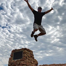
This hike has taken the top spot of my fave local hikes, hands down! It's the highest peak in the Santa Monica range and the views are just breathtaking. At one point I had to stop and take it all in and it was then that I suddenly realized I was looking right at the Pacific ocean lol! You can see absolutely everything it seems like - the SGV, the "valley", Malibu - you get it all here! This was also my first peak - and it's a really great one if you're looking for a first one to see what it's like - it's a relatively short "peak hike" - AllTrails says 3 miles but we did closer to 4 miles actually. And we gained just over 1000 feet in the first 1 3/4 miles - so it's definitely steep. I'd call it a moderate trail, but the last tiny bit up to the peak is definitely advanced. It's a steep rock face and doesn't have a well-defined path - and there aren't too many good foot holes - we did a lot of butt scooting - especially on the way down haha! The trail itself has lots of rocks and gravel too. The rain has caused some washed out areas - but the path is well maintained and wide enough to find decent areas to walk. And there's no people (we got there at 830am on a Monday)!! We only saw 2 other hikers right at the end for about 2 minutes and then 1 mountain biker coming up and that was it! It was so peaceful and quiet! Amazing! We even saw a large group of California Quail and a Red Tailed Hawk! It was super windy - especially at the peak. There was no ice or snow, but with the current weather pattern, it was absolutely FREEZING!! Luckily I planned ahead and brought gloves bc I did really need them. My fingers, legs, butt and face were all numb after being up at the peak! So check the weather before you go. And with the wind, I'm really glad I left my hat at home - it's crazy at the peak - be super aware bc it'll blow you down! I think poles will be helpful maybe coming down from the peak part - I brought a pole but never ended up using it. So I could take it or leave it - but it may help. Definitely be sure to have good hiking boots or trail shoes with good grip - you're gonna need it for the rock scrambling up to the peak. At the peak, there's a nice plaque in memory of a Boy Scout troop founder (the peak is also named "Mt Allen" for him). And there's a little box built into the bottom of the plaque that holds some pens and the registry for you to sign when you make it up to the peak! People have put all sorts of stuff in there - some of it funny and cool but some kind of cringe (I found a condom in there but at least it was still in the packaging haha)! There's plenty of parking right at the trailhead in a gravel lot. The road driving in is a little scary - lots of switchbacks with steep drops to one side and rock slide areas all around - so be careful. There's also pretty decent and well kept bathrooms and a trail map. The parking and trails are all well marked. The only time we got a little unsure of where to go was up close to the peak - it's not clear exactly what the best way up is so you just have to be brave and go for it!

We loved this trail! We came on a weekend and it was still very quite when we got there with very few people on the trail. Tons of wildflowers and amazing views of the Valley. It was truly Breathtaking! Tons of free parking in an open gravel lot made it easy to park right at the trailhead. Love that the trail was easy to follow so I didn't have to pull out my All Trails map until probably the last 100 ft or so as we neared the top. The only reason I had to pull it out at the end of the hike is because towards the peak it is basically just rock which makes the trail hard to see. That being said, there is a monument at the top that makes it easy to figure out where you should be headed so that helps to guide you the last bit of the way to the summit! Overall we loved it and can't wait to go back! Highly recommend!

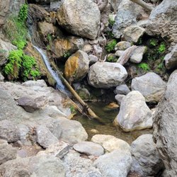
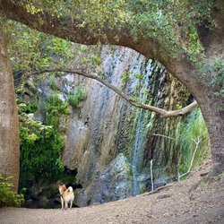
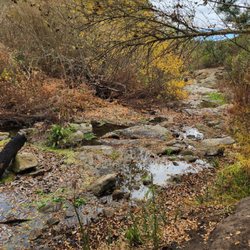
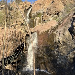
Moderate to strenuous trail to the highest spot in the Santa Monica Mountains (3133ft elevation). There's free parking available if you input Sandstone Peak trailhead. You could also park at the Mishe Mowka trailhead but that lot was a bit smaller and had more people. There are two bathrooms available at the Sandstone trailhead. You can opt to go clockwise for a shorter but steeper ascent, or counterclockwise for a longer but more gradual ascent. The trail connects to others like the Secret Grotto and the Balanced Rock trail. Note that the latter is a trail that's not maintained by the NPS so it's overgrown. The trail is rocky and to get up to the peak, you might need to strategically rock climb (in the loosest sense). Wear hiking boots, sneakers work give you good traction. There's little shade so wear sunscreen and bring a hat. Dogs are allowed on the trail. No permits are required to hike. You'll most likely not have signal so bring a map / check the trail beforehand. Overall, the trail provides a great workout and the opportunity to enjoy some fresh air away from the crowds.

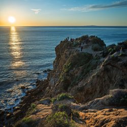
One of the prettier hikes in Malibu, I can just imagine how much more foliage there is during spring! We went Tuesday at 5pm and it was PERFECT! There were barely any people on the trail, tons of parking and the sunset was gorgeous. It was roughly 5mi from the parking until Inspiration Point which took us 2 hours back and forth. It was a fairly easy hike except for the first 500miles which was all uphill. The toilet area was closed but there were available portalets in place which was fairly clean.


This is a great hike for moderate to advanced level hikers. The trail head is about a mile past the circle X Ranch on the left side of Yerba Buena road (if you're coming from PCH). It is a 5.7 mile loop with an elevation gain of 1,300 feet. Be aware that there is very little shade on this hike so bring a hat, sunscreen and plenty of water. On the way up you will pass Echo Cliffs which is a sheer rock wall, and you will probably see rock climbers scaling it which is pretty cool. There are large, oddly shaped sandstone rock outcroppings everywhere. The trail is mostly loose gravel and rocks so it is best to wear proper hiking boots as opposed to fitness shoes. The trail was closed until January due to the massive fires last year. There are still-standing burnt trees and shrubs everywhere, but the black limbs actually look stunning against the blue sky and new growth that is popping out everywhere. As a matter of fact, I have never seen so many beautiful wildflowers on a hike this late in the year. When you reach the top and realize you are at the highest point the Santa Monica Mountains at over 3400 feet, you will definitely have a feeling of accomplishment while wiping the sweat and dust off your face.
")
1 year ago
A Magical Sunrise Hike to Sandstone Peak We recently did an early morning hike to Sandstone Peak in Malibu, and it was absolutely beautiful--one of those experiences that stays with you. To catch the sunrise above the clouds, we left home around 4:00 AM and got to the trailhead by 5:00. It was still dark when we started, but hiking under the stars added a peaceful, almost surreal feeling to the whole experience. The trail to the peak took us about an hour, and while it was a bit steep in places, it wasn't too difficult--definitely manageable, even if you're not a hardcore hiker. As we reached the top, just in time, the sky began to lighten and the sun rose slowly above a blanket of clouds. It was breathtaking. The way the light filtered through the mist and lit up the mountains around us was nothing short of magical. You really feel like you're on top of the world up there. Highly recommend this hike if you're up for an early start and want to witness something truly special. Bring water, good shoes, and a jacket--it's chilly before the sun comes up, but totally worth it. read more


2 years ago
The road up to Sandstone peak is rural, narrow, curvy, and well maintained. There is some danger of rock fall or slide, so make sure to check the weather before heading up! At the trailhead, there is a large dirt parking lot with two (absolutely disgusting) toilets, two (mostly clean) picnic tables, and a posted map. There are also paper copies of the map to the side of the trailhead sign. This is a moderately difficult hike and there is constant incline in the first half. There is some erosion, so wear proper shoes! There's plenty of places to take scenic photos. The path is somewhat overgrown in places. There were lots of dragonflies, butterflies, and a refreshing sea breeze! To get to the peak, expect to do a little scrabbling up the rock. read more


10 months ago
So beautiful. But I will warn it's all incline and about 1hr and 15 minutes to get to the top . Start trail no later then 5:30 am ! (: read more


2 years ago
One of my favorite hikes in the Malibu area. I would highly recommend hitting up this spot early in the morning (arriving to the trailhead at 4am-5am depending on the time of year) to experience sunrise above the clouds. Having a group of friends rolling out is always better and will help make the early morning a little more bearable (). This hike especially at that time isn't really crowded and is an obvious/wide trail. There are a couple different starting points but the closest one is only about 30/40mins hiking from the peak. Because you're going to a peak, plan on those 30/40mins to be all uphill. Make the most of it, plan a little time to recharge and relax afterward with a smoothie from SunLife Organics or coffee from Blue Bottle down in Malibu off PCH. One of the best ways to start your day or weekend! read more


Perfectly maintained, yet ruggedly beautiful trail that can see you bag one peak, 4 peaks, or however many peaks your 'lil legs will take you! The views are stunning from whichever trail you take or from any of the ridges and peaks and points you decide to stop and drink in you're surroundings. Parking Lots are nice and the pit toilets well-maintained. read more


This hike has taken the top spot of my fave local hikes, hands down! It's the highest peak in the Santa Monica range and the views are just breathtaking. At one point I had to stop and take it all in and it was then that I suddenly realized I was looking right at the Pacific ocean lol! You can see absolutely everything it seems like - the SGV, the "valley", Malibu - you get it all here! This was also my first peak - and it's a really great one if you're looking for a first one to see what it's like - it's a relatively short "peak hike" - AllTrails says 3 miles but we did closer to 4 miles actually. And we gained just over 1000 feet in the first 1 3/4 miles - so it's definitely steep. I'd call it a moderate trail, but the last tiny bit up to the peak is definitely advanced. It's a steep rock face and doesn't have a well-defined path - and there aren't too many good foot holes - we did a lot of butt scooting - especially on the way down haha! The trail itself has lots of rocks and gravel too. The rain has caused some washed out areas - but the path is well maintained and wide enough to find decent areas to walk. And there's no people (we got there at 830am on a Monday)!! We only saw 2 other hikers right at the end for about 2 minutes and then 1 mountain biker coming up and that was it! It was so peaceful and quiet! Amazing! We even saw a large group of California Quail and a Red Tailed Hawk! It was super windy - especially at the peak. There was no ice or snow, but with the current weather pattern, it was absolutely FREEZING!! Luckily I planned ahead and brought gloves bc I did really need them. My fingers, legs, butt and face were all numb after being up at the peak! So check the weather before you go. And with the wind, I'm really glad I left my hat at home - it's crazy at the peak - be super aware bc it'll blow you down! I think poles will be helpful maybe coming down from the peak part - I brought a pole but never ended up using it. So I could take it or leave it - but it may help. Definitely be sure to have good hiking boots or trail shoes with good grip - you're gonna need it for the rock scrambling up to the peak. At the peak, there's a nice plaque in memory of a Boy Scout troop founder (the peak is also named "Mt Allen" for him). And there's a little box built into the bottom of the plaque that holds some pens and the registry for you to sign when you make it up to the peak! People have put all sorts of stuff in there - some of it funny and cool but some kind of cringe (I found a condom in there but at least it was still in the packaging haha)! There's plenty of parking right at the trailhead in a gravel lot. The road driving in is a little scary - lots of switchbacks with steep drops to one side and rock slide areas all around - so be careful. There's also pretty decent and well kept bathrooms and a trail map. The parking and trails are all well marked. The only time we got a little unsure of where to go was up close to the peak - it's not clear exactly what the best way up is so you just have to be brave and go for it! read more

3 years ago
We loved this trail! We came on a weekend and it was still very quite when we got there with very few people on the trail. Tons of wildflowers and amazing views of the Valley. It was truly Breathtaking! Tons of free parking in an open gravel lot made it easy to park right at the trailhead. Love that the trail was easy to follow so I didn't have to pull out my All Trails map until probably the last 100 ft or so as we neared the top. The only reason I had to pull it out at the end of the hike is because towards the peak it is basically just rock which makes the trail hard to see. That being said, there is a monument at the top that makes it easy to figure out where you should be headed so that helps to guide you the last bit of the way to the summit! Overall we loved it and can't wait to go back! Highly recommend! read more


5 years ago
Moderate to strenuous trail to the highest spot in the Santa Monica Mountains (3133ft elevation). There's free parking available if you input Sandstone Peak trailhead. You could also park at the Mishe Mowka trailhead but that lot was a bit smaller and had more people. There are two bathrooms available at the Sandstone trailhead. You can opt to go clockwise for a shorter but steeper ascent, or counterclockwise for a longer but more gradual ascent. The trail connects to others like the Secret Grotto and the Balanced Rock trail. Note that the latter is a trail that's not maintained by the NPS so it's overgrown. The trail is rocky and to get up to the peak, you might need to strategically rock climb (in the loosest sense). Wear hiking boots, sneakers work give you good traction. There's little shade so wear sunscreen and bring a hat. Dogs are allowed on the trail. No permits are required to hike. You'll most likely not have signal so bring a map / check the trail beforehand. Overall, the trail provides a great workout and the opportunity to enjoy some fresh air away from the crowds. read more


One of the prettier hikes in Malibu, I can just imagine how much more foliage there is during spring! We went Tuesday at 5pm and it was PERFECT! There were barely any people on the trail, tons of parking and the sunset was gorgeous. It was roughly 5mi from the parking until Inspiration Point which took us 2 hours back and forth. It was a fairly easy hike except for the first 500miles which was all uphill. The toilet area was closed but there were available portalets in place which was fairly clean. read more


Good hiking trails; gorgeous views. Free parking- portable restroom in parking lot but no hand washing station available. Trails can be steep in places and rocky- be mindful of steps. Not much shade so plan accordingly. Dogs on leash allowed. read more

This is a great hike for moderate to advanced level hikers. The trail head is about a mile past the circle X Ranch on the left side of Yerba Buena road (if you're coming from PCH). It is a 5.7 mile loop with an elevation gain of 1,300 feet. Be aware that there is very little shade on this hike so bring a hat, sunscreen and plenty of water. On the way up you will pass Echo Cliffs which is a sheer rock wall, and you will probably see rock climbers scaling it which is pretty cool. There are large, oddly shaped sandstone rock outcroppings everywhere. The trail is mostly loose gravel and rocks so it is best to wear proper hiking boots as opposed to fitness shoes. The trail was closed until January due to the massive fires last year. There are still-standing burnt trees and shrubs everywhere, but the black limbs actually look stunning against the blue sky and new growth that is popping out everywhere. As a matter of fact, I have never seen so many beautiful wildflowers on a hike this late in the year. When you reach the top and realize you are at the highest point the Santa Monica Mountains at over 3400 feet, you will definitely have a feeling of accomplishment while wiping the sweat and dust off your face. read more


Good hike! We took the dogs with us and they enjoyed the climb to the peak too. The National Park Service was working on the trail when we went up. They made room for us to pass as we went by. Lots of friendly people on the trail today. Very clean and well maintained trails. Not a good one for kids. We slid several times. I whipped out and landed on my caboose. The climb to the peak has a lot of loose rocks. Great for solo or group hikes. read more
 - Hiking Near Me - Malibu, California")


7 years ago
More info about Sandstone Peak
12896 Yerba Buena Rd
Malibu, CA 90265
Directions
Hours
Outdoor Amenities
Ask the Community - Sandstone Peak
Review Highlights - Sandstone Peak


Sandstone Peak - hiking - Updated June 2026
Best of Malibu
People found Sandstone Peak by searching for…
Swimming Holes in Malibu, California
Stairs Workout in Malibu, California
Sunset View in Malibu, California
Scenic View in Malibu, California
Scenic Drive in Malibu, California
Photo Spots in Malibu, California
Fishing Spots in Malibu, California
Sunrise View in Malibu, California
Waterfall Hike in Malibu, California
Rock Climbing in Malibu, California
Hiking Trails in Malibu, California
Free Parking in Malibu, California
Fall Foliage in Malibu, California
Sunrise Hike in Malibu, California
Hiking Groups in Malibu, California
Picnic Spots in Malibu, California
Dog Friendly Hikes in Malibu, California
Things to Do in Malibu, California
Off Road Trails in Malibu, California
Walking Trails in Malibu, California
Secret Spots in Malibu, California
Trending Searches in Malibu, CA
Black Owned Nail Salons near Sandstone Peak
Boat Rental near Sandstone Peak
Cliff Jumping near Sandstone Peak
Dog Friendly Trails near Sandstone Peak
Fishing Spots near Sandstone Peak
Jet Ski Rental near Sandstone Peak
Kayak Rental near Sandstone Peak
Lakes & Ponds near Sandstone Peak
Outdoor Activities near Sandstone Peak
Places To Walk Around near Sandstone Peak
Public Pools near Sandstone Peak
Public Shower near Sandstone Peak
River Swimming near Sandstone Peak
Rock Quarry near Sandstone Peak
Scenic Night View near Sandstone Peak
Scenic Overlook near Sandstone Peak
Secluded Spots near Sandstone Peak
Soccer Store near Sandstone Peak
Splash Pad near Sandstone Peak
Strawberry Picking near Sandstone Peak
Sunrise View near Sandstone Peak
Swimming Holes near Sandstone Peak
Swimming Lakes near Sandstone Peak
Watch Sunset near Sandstone Peak
Browse Articles
Browse Nearby
BEST of Malibu, California Restaurants near Sandstone Peak
BEST of Malibu, California Coffee near Sandstone Peak
BEST of Malibu, California Breakfast near Sandstone Peak
BEST of Malibu, California Beaches near Sandstone Peak
BEST of Malibu, California Horseback Riding near Sandstone Peak
Browse Brands
Related Searches in Malibu, CA
Best Fishing Locations and Guides in Malibu, California
Best Nature Trails for Hiking in Malibu, California
Best Places for Horseback Riding in Malibu, California
Best Waterfalls and Swimming Holes in Malibu, California
Check Out Off Road Trails in Malibu, California
Discover Dog Friendly Trails to Explore in Malibu, California
Discover Kid Friendly Hiking Trails in Malibu, California
Discover Scenic Hiking Trails in Malibu, California
Discover Scenic Mountain Bike Trails Near Malibu, California
Discover Scenic Waterfall Spots in Malibu, California
Discover Walking Parks in Malibu, California Near You
Discover a Hiking Trail in Malibu, California
Discover the Best Night Hike Trails in Malibu, California
Discover the Best Running Track in Malibu, California
Dog-Friendly Hikes With Dogs in Malibu, California
Enjoy Camping Adventures Around Malibu, California
Enjoy Exciting Mountain Biking Adventures in Malibu, California
Enjoy Kayaking Adventures in Malibu, California
Enjoy Tent Camping Spots Around Malibu, California
Enjoy a Beautiful Waterfall Hike in Malibu, California
Enjoy the Best Walking Path in Malibu, California
Enjoy the Best Walking Trails in Malibu, California
Exciting Cliff Jumping Spots in Malibu, California
Explore Beautiful Parks and Green Spaces in Malibu, California
Explore Easy Hikes Perfect for All in Malibu, California
Explore Fun Activities to Do in Malibu, California
Explore Popular Campgrounds Near Malibu, California
Explore the Best Beach Spots in Malibu, California
Explore the Best Boating Spots in Malibu, California
Explore the Best Trail Options in Malibu, California
Family Friendly Hiking With Kids in Malibu, California
Find Beautiful Views in Malibu, California
Find the Best Parks for Picnics in Malibu, California
Find the Best Scenic View Locations in Malibu, California
Great Places to Walk in Malibu, California
Hike the Popular Waterfall Trail in Malibu, California
Hiking Trails With Waterfalls in Malibu, California
Off Leash Dog Hiking Trails in Malibu, California
Plan a Scenic Drive Route Near Malibu, California
Popular Outdoor Activities to Try in Malibu, California
Popular Picnic Spots to Visit in Malibu, California
Safe River Swimming Areas in Malibu, California
Safe and Fun Parks for Kids in Malibu, California
Top Climbing Spots and Gyms in Malibu, California
Top Paddleboarding Activities in Malibu, California
Top Running Trails to Explore in Malibu, California
Top Swimming Lakes to Enjoy in Malibu, California
Top Swimming Spots and Pools in Malibu, California
People who viewed Sandstone Peak also viewed
Topanga State Park
231 reviews
Pacific Palisades
Escondido Canyon Park
574 reviews
Point Dume Natural Preserve
113 reviews
Zuma Ridge Trail
5 reviews
Los Leones Canyon
462 reviews
Pacific Palisades
Circle X Ranch
51 reviews
Murphy Ranch Trail
319 reviews
Pacific Palisades
Saddle Peak Trail
3 reviews
Santa Paula Punch Bowls
68 reviews
Santa Paula Canyon Falls
17 reviews