Backbone Trail Photos


You might also consider
More like Backbone Trail
Recommended Reviews - Backbone Trail
Start your review...

Reviews With Photos


OVER SIXTY MILES OF TRAIL!! STATS: Over 67.5 miles, done over the course of several Saturday's Highest Point: 3,000ft. above sea level Rating: Intermediate-Strenuous, not for beginners Trail: Single Track, Fire Road, Multi-Use Back in the day when my goal was to get my hiking distance up and over two digits, I joined The Crew on this adventure, hiking the Backbone Trail (BBT). Broken up into seven sections, 67.5 miles were hiked over the course of seven weekend days. Hiked as a one way car shuttle, the ending point of the previous hike was the starting point of the next. The BBT was originally supposed to run from Griffith Park to Point Mugu, but that never happened. Instead, over the course of time, with the help of many volunteers and parkland agencies, the (BBT) now runs from Will Rogers State Historic Park to Point Mugu State Park anchored in the middle by Malibu Creek State Park. The BBT runs ridges, traverses chaparral-covered hillsides, oak woodlands, and crosses creeks and valleys. Section 1- Starting from the western point of the BBT, we made our way through Danielson Ranch via the Ray Miller Overlook, Wood Canyon Vista and Sycamore Canyon. This section of the Backbone Trail is totally within Pt. Mugu State Park. The trail climbs from sea level, through the exposed coastal sage and scrub, up over the ridge and down into the shaded Big Sycamore Canyon. After passing through Danielson Ranch, we hiked up and out of the canyon to the Rancho Sierra Vista parking area. Section 2- Traverses the only wilderness area in the Santa Monica Mountains. We hiked partly on the old fire road, partly on multi-use trails, and partly on single track trails. Passing through coastal sage/scrub, oak woodlands and chaparral, we hiked from just above sea level at Danielson Ranch to the highest point in the Santa Monica's (Sandstone Peak at 3111'). Section 3-Good ocean views while crossing brushy chaparral covered slopes then, like a roller coaster ride, up and down dips through shaded stream cut canyons and Oak Woodlands. Foliage included Coastal Sage Scrub, Chaparral, Oak Woodlands, Meadows, and Sycamore Savannahs. Section 4- Continues through Coastal Sage Scrub, Chaparral, Oak Woodlands, Meadows, and Sycamore Savannahs. In this section we came across some interesting geology in the wind and erosion carved sandstone and found some fossils in the rocks and on the trail. In this section, there was some passing of old housing foundation ruins and new private estates. Section 5- Took us through an area that has almost fully recovered from the devastating fire of 1993. In 1993 fires completely burned this area and natural recovery has restored it, but you can still see some evidences of that great fire. Elevation changes in this section are strong as well as slope aspects through shaded and sunny areas. Section 6- Was filled with gorgeous views from the Mountains Restoration Trust fossil trail. Following the Fossil Trail, we descended into state park property in Hondo Canyon. Through Hondo Canyon to eventually cross Old Topanga Canyon Road and then follow exceedingly obscure trails to cross Topanga Canyon Boulevard to reach Topanga State Park. Section 7-was a chaparral, streamside, meadow, oak woodland, coastal sage/scrub day on trail. While a little long, this is mostly a downhill hike ending by the polo fields of Will Rogers State Park. This has it all, something for every hiker. It offers long ridges, steep elevation, shaded canyons, ocean views, and a few water crossings. Clearly is this not a day hike, it takes a lot of planning and organizing, especially if done as a one way shuttle hike. If you're more into keeping the mileage well above 10 miles, it is possible to break the trails mileage up into five sections. It was good to find that I was able to hike for long distances and still get out of bed the next day. I was also an eye opener. It was then that I realized, I wasn't a ridge hiker. Put me in a canyon with some water to trudge through, boulders to climb, bush to whack, and I'm a happy hiker. DISCLAIMER: Hiking is not something that can be taken lightly. It can be life-threatening as you see and hear on the news, people die or get lost all time. Please, if you are going to hike, never go alone and prepare for the worst, hope for the best. Remember when going for a hike, no matter how short you think it may be, always be prepared. Carry at least two liters of water for every five miles (more if the weather is warm), protein bar, nuts, and electrolytes. Wear sturdy lug sole shoes and protective clothing. Some areas the weather can change quicker than a fireman can put on his gear. It is also very important, always always always let a family member or friend know where you are going and when you expect to be back. Lastly, have fun when you hike it up.

I'm surprised I haven't done a review for this one yet, It's one I frequently hit. This trail crosses the Santa Monica Mountains at a total of 69 miles and this section I"m writing about is just one piece of it. This part of the trail you can go for 2.5 miles and it's really pretty right now in the spring with blooming flowers, stream running through below and plenty of green. Summer time it becomes dry and hard to do in the heat if you don't get an early start. It has inclines here and there but nothing complicated- I've seen bikers on this one although I would not be able to bring my Mountain Bike to this- just not skilled enough to pick a line around those graveled rock areas and there are a few sections it becomes single trek which is difficult with the amount of hikers that come here. Come super early Mountain Bikers :)) You can print the map out on line of this entire trail and places to catch it.

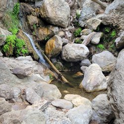
This is the trail that you kinda get a glimpse of as you are speeding through tunnels on Kanan Rd on your way to the beach. The Yelp page for this location is unfortunately not very specific; Backbone Trail is almost 67 miles long! A better title would be Kanan Rd Trailhead on the Backbone Trail. After you park you'll have to decide between two very different trails, Zuma Ridge Motorway or Latigo Canyon Trailhead. Zuma Ridge trailhead takes you down into Newton Canyon and then climbs you back up where you hike along the mountain ridge. It pretty much runs along the path of the canyon's creek. It feels more isolated and lower elevation as compared to Latigo. I would choose this option if you are looking for a long hike (over 5 miles round trip) and if you enjoy hearing the sounds of trickling water (and frogs) along the way. It eventually will lead you to a small "waterfall" called Newton Falls. The Zuma Ridge trail quickly climbs you up a mountain ridge and then it takes you over a tunnel. You'll get some nice views of luxury homes. It's cool viewing the Kanan Rd tunnel from a bird's eye perspective. It's a better option if you are more interested in a good workout or a shorter hike. Here are some interesting bits of info that I learned from the park service pamphlet. The word Zuma is derived from Chumash language and it means "abundance." On your hike you might hear the sounds of the shy wrentit. It is rarely seen but can be heard by its distinctive ping pong sound that it makes. It's been called the "voice of chaparral."

Superb Trail for Hiking! We went on Christmas Day 2016 on this Trail. Hiked 6.5 miles in almost 4 hours. We were a party of 8 adults 4 children plus a dog. We started at the Tapia Trail Head and ended at the coral canyon end. Kept 2 cars at each end coz coming back 6.5 miles again was not possible. We walked 16000 steps that day on the trail alone. Magnificent views of the Valley and and Pacific! Will hike Part 2 coming week probably.

I had this place bookmarked but didn't know it was also a part of the Latigo canyon trail. Hiked this today from Latigo canyon road and wanted to make it to corral canyon, but I stopped with maybe a mile left cause my dog was not going to make it. I have a maltese and the four mile trek to corral canyon would've been too much and then we would need to go back. I found the trail through an article http://www.examiner.com/article/hiking-the-backbone-trail-from-latigo-canyon-road-to-castro-crest-malibu and it was definitely helpful in getting there. Turn right to Latigo canyon road from pch and drive about 7 miles till you get to a dirt lot. You won't be able to miss it. I thought I would but you will recognize a dirt parking lot when you see it (keep going past the winery and you will be close). The road is very winding up to the trail head so I suggest you take it slow. I was going about 20 mph the whole way because there are many mountain bikers and other cars going down at a fast speed and sometimes you can't see around the bend. The trail is pretty narrow but not too bad. It was gravelly but overall not a strenuous hike, just long. I enjoyed it a lot, especially because it wasn't hot and there was a lot of shade. I suggest hiking with a buddy, because this trail is not very well known with hikers. I saw a lot of mountain bikers so you're not completely isolated, but the trail can get lonely. It is about 1.5 miles to get to the antennas, and another 3ish miles to get to corral canyon. I did meet one hiker who told me to be careful with ticks during this time. I was worried about my dog, but I suggest just watching your pet closely and giving him or her a thorough bath once you get home. I would definitely come back here again to complete the trail since it was a good work out, but not have my dog with me since 4 miles is the max she can do.

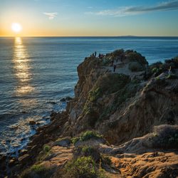
Breathtaking view. fairly easy hike. Totally worth the scenery and vast beauty you encounter during your hike. It is a total of 8.4 miles to hike and I love that it is not crowded at all. If you are in the area, I recommend this hike. I believe it is dog friendly as well. The whole hike took me about 3 hours with mini stops to enjoy the beautiful scenery and view of Malibu beach.


Well, we were aiming for the Solstice trail and epically failed, so maybe next time :) haha But the backbone trail we only went 3 miles in and turned around, but it's definitely beautiful! And such a long trail. Can se all the greens, Definitely glad we went early in the morning! And i wouldn't want to do it in the middle of heat, and it's only February....

I do not recommend this Trail 4 mountain bikes. A good portion of it is not even open for bikes and you are risking getting a ticket from the Ranger. In addition, you will find yourself carrying your bike uphill for miles and making numerous stops getting off and on the bike over Boulder's. Yes, the views are breathtaking. Next time I might be hiking it.

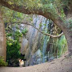
You cannot go wrong hiking in Cali....especially when you are in Malibu! This trail can be super busy, especially on early morning weekends! A nice time to visit in the summer is about 6pm on a weekday! Besides our group, we did not see a single person on the trail nor did we have to fight for a parking spot. Note there are two small parking lots both off highway before the tunnel if coming from 101. From the trail there are beautiful views of the mountains and the canyons. you can even see views of the ocean in malibu. when there is a wet winter season, you can see loads of waterfalls. my fellow hiker said she saw 18 falls. Worth visiting during the wet season. Just be careful. also note there is poisonous oak along the trail. Unfortunately in July the falls were all dry. There was some water in the creeks. As for amenities: there is a toilet at the start of the trail. read more


1 year ago
This is not for the beginner hiker. You'll need hiking poles and lots of water. Other than that, it's a great trail! The hardest part is the first mile. If you can get thru that, everything else will be a breeze. At mile 2-3 you'll reach the fire lookout point. It takes about 3-4 hours to finish this trail depending on how fast you're going. read more


Oh boy this trail is LONG. Unpleasantly LONG. With no final destination you just walk and walk and walk and walk with pretty much the same scenery. There is a waterfall in the beginning somewhere down there but there is no clear indication how to get there. Only 3 people I have met during my hike. I stopped at this sign and walked back. Horrible, unpleasant and boring. Not recommended read more


10 years ago
OVER SIXTY MILES OF TRAIL!! STATS: Over 67.5 miles, done over the course of several Saturday's Highest Point: 3,000ft. above sea level Rating: Intermediate-Strenuous, not for beginners Trail: Single Track, Fire Road, Multi-Use Back in the day when my goal was to get my hiking distance up and over two digits, I joined The Crew on this adventure, hiking the Backbone Trail (BBT). Broken up into seven sections, 67.5 miles were hiked over the course of seven weekend days. Hiked as a one way car shuttle, the ending point of the previous hike was the starting point of the next. The BBT was originally supposed to run from Griffith Park to Point Mugu, but that never happened. Instead, over the course of time, with the help of many volunteers and parkland agencies, the (BBT) now runs from Will Rogers State Historic Park to Point Mugu State Park anchored in the middle by Malibu Creek State Park. The BBT runs ridges, traverses chaparral-covered hillsides, oak woodlands, and crosses creeks and valleys. Section 1- Starting from the western point of the BBT, we made our way through Danielson Ranch via the Ray Miller Overlook, Wood Canyon Vista and Sycamore Canyon. This section of the Backbone Trail is totally within Pt. Mugu State Park. The trail climbs from sea level, through the exposed coastal sage and scrub, up over the ridge and down into the shaded Big Sycamore Canyon. After passing through Danielson Ranch, we hiked up and out of the canyon to the Rancho Sierra Vista parking area. Section 2- Traverses the only wilderness area in the Santa Monica Mountains. We hiked partly on the old fire road, partly on multi-use trails, and partly on single track trails. Passing through coastal sage/scrub, oak woodlands and chaparral, we hiked from just above sea level at Danielson Ranch to the highest point in the Santa Monica's (Sandstone Peak at 3111'). Section 3-Good ocean views while crossing brushy chaparral covered slopes then, like a roller coaster ride, up and down dips through shaded stream cut canyons and Oak Woodlands. Foliage included Coastal Sage Scrub, Chaparral, Oak Woodlands, Meadows, and Sycamore Savannahs. Section 4- Continues through Coastal Sage Scrub, Chaparral, Oak Woodlands, Meadows, and Sycamore Savannahs. In this section we came across some interesting geology in the wind and erosion carved sandstone and found some fossils in the rocks and on the trail. In this section, there was some passing of old housing foundation ruins and new private estates. Section 5- Took us through an area that has almost fully recovered from the devastating fire of 1993. In 1993 fires completely burned this area and natural recovery has restored it, but you can still see some evidences of that great fire. Elevation changes in this section are strong as well as slope aspects through shaded and sunny areas. Section 6- Was filled with gorgeous views from the Mountains Restoration Trust fossil trail. Following the Fossil Trail, we descended into state park property in Hondo Canyon. Through Hondo Canyon to eventually cross Old Topanga Canyon Road and then follow exceedingly obscure trails to cross Topanga Canyon Boulevard to reach Topanga State Park. Section 7-was a chaparral, streamside, meadow, oak woodland, coastal sage/scrub day on trail. While a little long, this is mostly a downhill hike ending by the polo fields of Will Rogers State Park. This has it all, something for every hiker. It offers long ridges, steep elevation, shaded canyons, ocean views, and a few water crossings. Clearly is this not a day hike, it takes a lot of planning and organizing, especially if done as a one way shuttle hike. If you're more into keeping the mileage well above 10 miles, it is possible to break the trails mileage up into five sections. It was good to find that I was able to hike for long distances and still get out of bed the next day. I was also an eye opener. It was then that I realized, I wasn't a ridge hiker. Put me in a canyon with some water to trudge through, boulders to climb, bush to whack, and I'm a happy hiker. DISCLAIMER: Hiking is not something that can be taken lightly. It can be life-threatening as you see and hear on the news, people die or get lost all time. Please, if you are going to hike, never go alone and prepare for the worst, hope for the best. Remember when going for a hike, no matter how short you think it may be, always be prepared. Carry at least two liters of water for every five miles (more if the weather is warm), protein bar, nuts, and electrolytes. Wear sturdy lug sole shoes and protective clothing. Some areas the weather can change quicker than a fireman can put on his gear. It is also very important, always always always let a family member or friend know where you are going and when you expect to be back. Lastly, have fun when you hike it up. read more


I'm surprised I haven't done a review for this one yet, It's one I frequently hit. This trail crosses the Santa Monica Mountains at a total of 69 miles and this section I"m writing about is just one piece of it. This part of the trail you can go for 2.5 miles and it's really pretty right now in the spring with blooming flowers, stream running through below and plenty of green. Summer time it becomes dry and hard to do in the heat if you don't get an early start. It has inclines here and there but nothing complicated- I've seen bikers on this one although I would not be able to bring my Mountain Bike to this- just not skilled enough to pick a line around those graveled rock areas and there are a few sections it becomes single trek which is difficult with the amount of hikers that come here. Come super early Mountain Bikers :)) You can print the map out on line of this entire trail and places to catch it. read more


This is the trail that you kinda get a glimpse of as you are speeding through tunnels on Kanan Rd on your way to the beach. The Yelp page for this location is unfortunately not very specific; Backbone Trail is almost 67 miles long! A better title would be Kanan Rd Trailhead on the Backbone Trail. After you park you'll have to decide between two very different trails, Zuma Ridge Motorway or Latigo Canyon Trailhead. Zuma Ridge trailhead takes you down into Newton Canyon and then climbs you back up where you hike along the mountain ridge. It pretty much runs along the path of the canyon's creek. It feels more isolated and lower elevation as compared to Latigo. I would choose this option if you are looking for a long hike (over 5 miles round trip) and if you enjoy hearing the sounds of trickling water (and frogs) along the way. It eventually will lead you to a small "waterfall" called Newton Falls. The Zuma Ridge trail quickly climbs you up a mountain ridge and then it takes you over a tunnel. You'll get some nice views of luxury homes. It's cool viewing the Kanan Rd tunnel from a bird's eye perspective. It's a better option if you are more interested in a good workout or a shorter hike. Here are some interesting bits of info that I learned from the park service pamphlet. The word Zuma is derived from Chumash language and it means "abundance." On your hike you might hear the sounds of the shy wrentit. It is rarely seen but can be heard by its distinctive ping pong sound that it makes. It's been called the "voice of chaparral." read more


10 years ago
Superb Trail for Hiking! We went on Christmas Day 2016 on this Trail. Hiked 6.5 miles in almost 4 hours. We were a party of 8 adults 4 children plus a dog. We started at the Tapia Trail Head and ended at the coral canyon end. Kept 2 cars at each end coz coming back 6.5 miles again was not possible. We walked 16000 steps that day on the trail alone. Magnificent views of the Valley and and Pacific! Will hike Part 2 coming week probably. read more


5 years ago
8 years ago
10 years ago
I had this place bookmarked but didn't know it was also a part of the Latigo canyon trail. Hiked this today from Latigo canyon road and wanted to make it to corral canyon, but I stopped with maybe a mile left cause my dog was not going to make it. I have a maltese and the four mile trek to corral canyon would've been too much and then we would need to go back. I found the trail through an article http://www.examiner.com/article/hiking-the-backbone-trail-from-latigo-canyon-road-to-castro-crest-malibu and it was definitely helpful in getting there. Turn right to Latigo canyon road from pch and drive about 7 miles till you get to a dirt lot. You won't be able to miss it. I thought I would but you will recognize a dirt parking lot when you see it (keep going past the winery and you will be close). The road is very winding up to the trail head so I suggest you take it slow. I was going about 20 mph the whole way because there are many mountain bikers and other cars going down at a fast speed and sometimes you can't see around the bend. The trail is pretty narrow but not too bad. It was gravelly but overall not a strenuous hike, just long. I enjoyed it a lot, especially because it wasn't hot and there was a lot of shade. I suggest hiking with a buddy, because this trail is not very well known with hikers. I saw a lot of mountain bikers so you're not completely isolated, but the trail can get lonely. It is about 1.5 miles to get to the antennas, and another 3ish miles to get to corral canyon. I did meet one hiker who told me to be careful with ticks during this time. I was worried about my dog, but I suggest just watching your pet closely and giving him or her a thorough bath once you get home. I would definitely come back here again to complete the trail since it was a good work out, but not have my dog with me since 4 miles is the max she can do. read more


Breathtaking view. fairly easy hike. Totally worth the scenery and vast beauty you encounter during your hike. It is a total of 8.4 miles to hike and I love that it is not crowded at all. If you are in the area, I recommend this hike. I believe it is dog friendly as well. The whole hike took me about 3 hours with mini stops to enjoy the beautiful scenery and view of Malibu beach. read more


8 years ago
Awesome Hike in Malibu. The opposite of Runyon. No crowds, challenging inclines! On some days you can see the Pacific Ocean, depending on the amount of Marine Layer Present. read more


10 years ago
Well, we were aiming for the Solstice trail and epically failed, so maybe next time :) haha But the backbone trail we only went 3 miles in and turned around, but it's definitely beautiful! And such a long trail. Can se all the greens, Definitely glad we went early in the morning! And i wouldn't want to do it in the middle of heat, and it's only February.... read more


10 years ago
I do not recommend this Trail 4 mountain bikes. A good portion of it is not even open for bikes and you are risking getting a ticket from the Ranger. In addition, you will find yourself carrying your bike uphill for miles and making numerous stops getting off and on the bike over Boulder's. Yes, the views are breathtaking. Next time I might be hiking it. read more

7 years ago
This was probably one of my favorite hikes! First off, it was completely empty (not only because it's a hidden gem, but because it was sprinkling) There is a lot right outside the entrance. But there's limited parking spaces! Not a lot. So be sure to get here quite early! I did not see any other spots (street parking) you could potentially park at. The bathrooms are CLEAN!! I was in shock. I was expecting it to be dirty with urine everywhere but it wasn't! I was quite pleased. TRAIL: This trail is really easy. It had some uphill, but nothing too hard. I think it would be a good trail for beginners. It's an enjoyable experience. I do not recommend strollers / or any of that sort. It does have some rocky parts in the beginning of the trail. The trail is 2.5 miles long. However, If you continue to go on to a different trail, the 2.5 miles stretch out to 8 miles. read more


11 years ago
8 years ago
9 years ago
8 years ago
9 years ago
10 years ago
9 years ago
Not to shabby but the down fall is the trail is not suitable for a stroller & the water fall was not as eye catching as it is online. There is however nice view's read more

9 years ago
11 years ago
10 years ago
More info about Backbone Trail
Kanan Dume Rd
Santa Monica Mountains National Recreation Area
Malibu, CA 90265
Directions
Hours
Indoor Amenities
Outdoor Amenities
Ask the Community - Backbone Trail
Review Highlights - Backbone Trail
You might also consider


Why does Yelp recommend reviews?
2 reviews that are not currently recommended
The reviews below are not factored into the business's overall star rating.
4 years ago
8 years ago
Backbone Trail - hiking - Updated June 2026
Best of Malibu
People found Backbone Trail by searching for…
Waterfall Hike in Malibu, California
Dog Friendly Beaches in Malibu, California
Hiking Trails in Malibu, California
Off Road Trails in Malibu, California
Scenic View in Malibu, California
Sunrise View in Malibu, California
Easy Hikes in Malibu, California
Running Trails in Malibu, California
Scenic Overlook in Malibu, California
Hiking Trails Kid Friendly in Malibu, California
Flower Field in Malibu, California
Free Campgrounds in Malibu, California
Natural Hot Springs in Malibu, California
Kids Friendly Beaches in Malibu, California
Sunrise Hike in Malibu, California
Sunset View in Malibu, California
Walking Trails in Malibu, California
Secret Spots in Malibu, California
Things to Do on a Rainy Day in Malibu, California
Photo Spots in Malibu, California
Trending Searches in Malibu, CA
Black Owned Nail Salons near Backbone Trail
Boat Rental near Backbone Trail
Cliff Jumping near Backbone Trail
Dog Friendly Trails near Backbone Trail
Fishing Spots near Backbone Trail
Jet Ski Rental near Backbone Trail
Kayak Rental near Backbone Trail
Lakes & Ponds near Backbone Trail
Outdoor Activities near Backbone Trail
Places To Walk Around near Backbone Trail
Public Pools near Backbone Trail
Public Shower near Backbone Trail
River Swimming near Backbone Trail
Rock Quarry near Backbone Trail
Scenic Night View near Backbone Trail
Scenic Overlook near Backbone Trail
Secluded Spots near Backbone Trail
Soccer Store near Backbone Trail
Splash Pad near Backbone Trail
Strawberry Picking near Backbone Trail
Sunrise View near Backbone Trail
Swimming Holes near Backbone Trail
Swimming Lakes near Backbone Trail
Watch Sunset near Backbone Trail
Browse Articles
Browse Nearby
BEST of Malibu, California Restaurants near Backbone Trail
BEST of Malibu, California Coffee near Backbone Trail
BEST of Malibu, California Things to Do near Backbone Trail
BEST of Malibu, California Breakfast near Backbone Trail
BEST of Malibu, California Beaches near Backbone Trail
BEST of Malibu, California Horseback Riding near Backbone Trail
Browse Brands
Related Searches in Malibu, CA
Best Fishing Locations and Guides in Malibu, California
Best Nature Trails for Hiking in Malibu, California
Best Places for Horseback Riding in Malibu, California
Best Waterfalls and Swimming Holes in Malibu, California
Check Out Off Road Trails in Malibu, California
Discover Dog Friendly Trails to Explore in Malibu, California
Discover Kid Friendly Hiking Trails in Malibu, California
Discover Scenic Hiking Trails in Malibu, California
Discover Scenic Mountain Bike Trails Near Malibu, California
Discover Scenic Waterfall Spots in Malibu, California
Discover Walking Parks in Malibu, California Near You
Discover a Hiking Trail in Malibu, California
Discover the Best Night Hike Trails in Malibu, California
Discover the Best Running Track in Malibu, California
Dog-Friendly Hikes With Dogs in Malibu, California
Enjoy Camping Adventures Around Malibu, California
Enjoy Exciting Mountain Biking Adventures in Malibu, California
Enjoy Kayaking Adventures in Malibu, California
Enjoy Tent Camping Spots Around Malibu, California
Enjoy a Beautiful Waterfall Hike in Malibu, California
Enjoy the Best Walking Path in Malibu, California
Enjoy the Best Walking Trails in Malibu, California
Exciting Cliff Jumping Spots in Malibu, California
Explore Beautiful Parks and Green Spaces in Malibu, California
Explore Easy Hikes Perfect for All in Malibu, California
Explore Fun Activities to Do in Malibu, California
Explore Popular Campgrounds Near Malibu, California
Explore the Best Beach Spots in Malibu, California
Explore the Best Boating Spots in Malibu, California
Explore the Best Trail Options in Malibu, California
Family Friendly Hiking With Kids in Malibu, California
Find Beautiful Views in Malibu, California
Find the Best Parks for Picnics in Malibu, California
Find the Best Scenic View Locations in Malibu, California
Great Places to Walk in Malibu, California
Hike the Popular Waterfall Trail in Malibu, California
Hiking Trails With Waterfalls in Malibu, California
Off Leash Dog Hiking Trails in Malibu, California
Plan a Scenic Drive Route Near Malibu, California
Popular Outdoor Activities to Try in Malibu, California
Popular Picnic Spots to Visit in Malibu, California
Safe River Swimming Areas in Malibu, California
Safe and Fun Parks for Kids in Malibu, California
Top Climbing Spots and Gyms in Malibu, California
Top Paddleboarding Activities in Malibu, California
Top Running Trails to Explore in Malibu, California
Top Swimming Lakes to Enjoy in Malibu, California
Top Swimming Spots and Pools in Malibu, California
People who viewed Backbone Trail also viewed
Solstice Canyon
459 reviews
Corral Canyon Park
74 reviews
Newton Canyon Falls
4 reviews
Saddle Peak Trail
3 reviews
Red Rock Canyon Park
35 reviews
Upper Las Virgenes Canyon Open Space Preserve
84 reviews
Point Dume Natural Preserve
113 reviews
Escondido Canyon Park
574 reviews
Topanga Lookout Trail
67 reviews
Piuma/Stunt Trailhead
11 reviews