Roanoke River Greenway Photos


More like Roanoke River Greenway
Recommended Reviews - Roanoke River Greenway
Start your review...

9 months ago
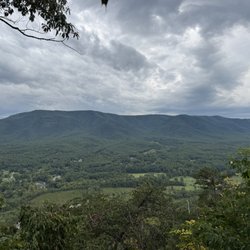
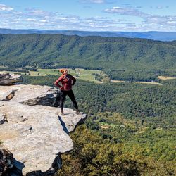
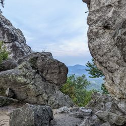
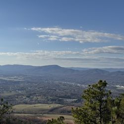
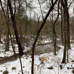
In all this is around a thirty mile stretch running through Salem, Roanoke Star. I walked a few miles and saw a lot of activity on a Saturday morning. For a first time experience I liked it, but could benefit from extending my walk. It's pretty and has some inclines. Part of the walk is along the River. read more


More info about Roanoke River Greenway
Roanoke, VA 24011
Directions
Hours
Outdoor Amenities


Roanoke River Greenway - hiking - Updated May 2026
Best of Roanoke
People found Roanoke River Greenway by searching for…
Things to Do in Roanoke, Virginia
Fun Things to Do at Night in Roanoke, Virginia
Walking Trails in Roanoke, Virginia
Hiking Trails in Roanoke, Virginia
Running Trails in Roanoke, Virginia
Scenic Views in Roanoke, Virginia
Places to Walk Around in Roanoke, Virginia
Bike Paths in Roanoke, Virginia
Waterfalls in Roanoke, Virginia
What to Do in Roanoke, Virginia
Dog Friendly Hiking Trails in Roanoke, Virginia
Places to Go in Roanoke, Virginia
Trending Searches in Roanoke, VA
Baseball Fields near Roanoke River Greenway
Boat Rental near Roanoke River Greenway
Bounce House Rentals near Roanoke River Greenway
Campgrounds near Roanoke River Greenway
Cheap Plants near Roanoke River Greenway
Floral Designers near Roanoke River Greenway
Flower Shop near Roanoke River Greenway
Garage Sales near Roanoke River Greenway
Garden Center near Roanoke River Greenway
Nurseries & Gardening near Roanoke River Greenway
Outdoor Activities near Roanoke River Greenway
Outdoor Furniture Stores near Roanoke River Greenway
Parks near Roanoke River Greenway
Party Equipment Rentals near Roanoke River Greenway
Pedicure near Roanoke River Greenway
Photo Spots near Roanoke River Greenway
Picnic Areas near Roanoke River Greenway
Places To Take Pictures near Roanoke River Greenway
Running Trails near Roanoke River Greenway
Rv Rental near Roanoke River Greenway
Scenic Drive near Roanoke River Greenway
Sunrise View near Roanoke River Greenway
Swimming Holes near Roanoke River Greenway
Table And Chair Rentals near Roanoke River Greenway
Browse Articles
Browse Nearby
BEST of Roanoke, Virginia Restaurants near Roanoke River Greenway
BEST of Roanoke, Virginia Things to Do near Roanoke River Greenway
BEST of Roanoke, Virginia Coffee near Roanoke River Greenway
BEST of Roanoke, Virginia Parks near Roanoke River Greenway
BEST of Roanoke, Virginia Breakfast near Roanoke River Greenway
BEST of Roanoke, Virginia Museums near Roanoke River Greenway
BEST of Roanoke, Virginia Hotels near Roanoke River Greenway
Browse Brands
Related Searches in Roanoke, VA
Affordable Kayak Rental Services in Roanoke, Virginia
Best Fishing Locations and Guides in Roanoke, Virginia
Best Places for Horseback Riding in Roanoke, Virginia
Check Out Off Road Trails in Roanoke, Virginia
Discover Dog Friendly Trails to Explore in Roanoke, Virginia
Discover Kid Friendly Hiking Trails in Roanoke, Virginia
Discover a Hiking Trail in Roanoke, Virginia
Dog-Friendly Hikes With Dogs in Roanoke, Virginia
Enjoy Camping Adventures Around Roanoke, Virginia
Enjoy Exciting Mountain Biking Adventures in Roanoke, Virginia
Enjoy River Tubing Adventures in Roanoke, Virginia
Enjoy a Beautiful Waterfall Hike in Roanoke, Virginia
Enjoy the Best Tubing Experiences in Roanoke, Virginia
Enjoy the Best Walking Trails in Roanoke, Virginia
Experience Thrilling White Water Rafting in Roanoke, Virginia
Explore Beautiful Parks and Green Spaces in Roanoke, Virginia
Explore Bike Rentals Throughout Roanoke, Virginia
Explore Easy Hikes Perfect for All in Roanoke, Virginia
Explore Free Things to Do Around Roanoke, Virginia
Explore Fun Activities to Do in Roanoke, Virginia
Explore Popular Campgrounds Near Roanoke, Virginia
Explore Popular Scenic Overlook Points in Roanoke, Virginia
Explore Popular View Points Around Roanoke, Virginia
Explore Scenic Lakes to Visit in Roanoke, Virginia
Explore Top Dog Parks in Roanoke, Virginia Near You
Explore the Best Boating Spots in Roanoke, Virginia
Explore the Best Trail Options in Roanoke, Virginia
Family Friendly Hiking With Kids in Roanoke, Virginia
Find Beautiful Views in Roanoke, Virginia
Find Popular Ziplining Spots Around Roanoke, Virginia
Find the Best Parks for Picnics in Roanoke, Virginia
Find the Best Playgrounds to Visit in Roanoke, Virginia
Find the Best Scenic View Locations in Roanoke, Virginia
Hiking Trails With Waterfalls in Roanoke, Virginia
Off Leash Dog Hiking Trails in Roanoke, Virginia
Plan a Scenic Drive Route Near Roanoke, Virginia
Popular Fishing Spots to Explore in Roanoke, Virginia
Popular Kids Activities in Roanoke, Virginia
Popular Outdoor Activities to Try in Roanoke, Virginia
Popular Picnic Spots to Visit in Roanoke, Virginia
Popular Things to Do in Roanoke, Virginia
Safe River Swimming Areas in Roanoke, Virginia
Safe and Fun Parks for Kids in Roanoke, Virginia
Top Paddleboarding Activities in Roanoke, Virginia
Top Playgrounds for Kids to Enjoy in Roanoke, Virginia
Top Running Trails to Explore in Roanoke, Virginia
Top Swimming Lakes to Enjoy in Roanoke, Virginia
Top Swimming Spots and Pools in Roanoke, Virginia