Riverside Park Photos


You might also consider
More like Riverside Park
Recommended Reviews - Riverside Park
Start your review...

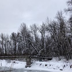
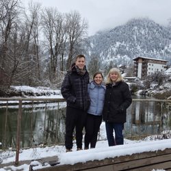
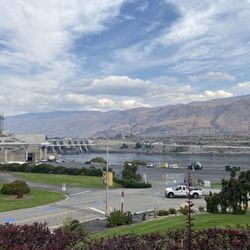
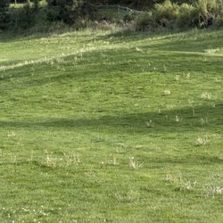
Riverside Park runs alongside the Wenatchee River in Cashmere. A paved walking path extends along the river and is beautiful to walk in the autumn. I recently walked this trail with my uncle and my aunt the three mornings I was in Cashmere visiting them (the 10th, 11th, and 12th of November 2020). The leaves were various colors and had started falling over the path, the branches of the trees filtered in the sunlight in patches providing a very autumn feel while walking. Along the river the wind can be strong so if walking in cooler temperatures it is a good idea to wear multiple layers. My uncle and I walked down one of the slopes by the walking trail to the river's edge. Across the river Highway 2 was rumbling with cars and trucks on their way to somewhere. In addition to the walking trail there is a large field area, multiple playgrounds one of which in primarily devoted to swings, a paved skate park and a dirt skate park, and a large picnic area where one can sit and relax. I spotted a couple of restroom buildings but did not go over to check if they were open or closed (due to COVID-19). A cement ramp leads into the river and provides a place one could launch or remove a river rafting boat from the water. On each of our visits, the park was calm and not too busy with people. read more


More info about Riverside Park
201 Riverside Dr
Cashmere, WA 98815
Directions
Hours
Outdoor Amenities


Riverside Park - parks - Updated June 2026
Best of Cashmere
People found Riverside Park by searching for…
Playgrounds in Cashmere, Washington
Things to Do in Cashmere, Washington
Water Parks in Cashmere, Washington
Photo Spots in Cashmere, Washington
Hiking Trails With Waterfalls in Cashmere, Washington
Skate Parks in Cashmere, Washington
Picnic Areas in Cashmere, Washington
Walking Trails in Cashmere, Washington
Parks for Kids in Cashmere, Washington
Places to Take Pictures in Cashmere, Washington
River Swimming in Cashmere, Washington
View Points in Cashmere, Washington
Scenic View in Cashmere, Washington
Picnic Spots in Cashmere, Washington
Running Trails in Cashmere, Washington
Beautiful Views in Cashmere, Washington
Playgrounds for Kids in Cashmere, Washington
Family Fun in Cashmere, Washington
Boat Launch in Cashmere, Washington
BBQ Park in Cashmere, Washington
Night View in Cashmere, Washington
Scenic Spots in Cashmere, Washington
Trending Searches in Cashmere, WA
Baseball Fields near Riverside Park
Blueberry Picking near Riverside Park
Boat Rental near Riverside Park
Cliff Jumping near Riverside Park
Fishing Spots near Riverside Park
Fruit Picking near Riverside Park
Jet Ski Rental near Riverside Park
Kayak Rental near Riverside Park
Places To Swim near Riverside Park
River Swimming near Riverside Park
River Tubing near Riverside Park
Strawberry Picking near Riverside Park
Swimming Holes near Riverside Park
Swimming Lakes near Riverside Park
Browse Articles
Browse Nearby
BEST of Cashmere, Washington Things to Do near Riverside Park
BEST of Cashmere, Washington Hiking near Riverside Park
BEST of Cashmere, Washington Restaurants near Riverside Park
BEST of Cashmere, Washington Coffee near Riverside Park
BEST of Cashmere, Washington Picnic Areas near Riverside Park
BEST of Cashmere, Washington Campgrounds near Riverside Park
BEST of Cashmere, Washington Lodging near Riverside Park
BEST of Cashmere, Washington Breakfast near Riverside Park
BEST of Cashmere, Washington Natural Hot Springs near Riverside Park
Browse Brands
Related Searches in Cashmere, WA
Best Fishing Locations and Guides in Cashmere, Washington
Best Off Leash Dog Parks in Cashmere, Washington
Best Water Parks for Kids in Cashmere, Washington
Check Out Great Playgrounds in Cashmere, Washington
Check Out Off Road Trails in Cashmere, Washington
Discover Beautiful Garden Spots in Cashmere, Washington
Discover Fun Activities to Do in Cashmere, Washington
Discover Top Nature Parks to Visit in Cashmere, Washington
Discover the Best Beaches in Cashmere, Washington
Enjoy the Best Family Activities in Cashmere, Washington
Enjoy the Best Picnic Spots and Ideas in Cashmere, Washington
Enjoy the Best Walking Trails in Cashmere, Washington
Explore Free Things to Do Around Cashmere, Washington
Explore Fun Activities to Do in Cashmere, Washington
Explore Kid Friendly Places and Events in Cashmere, Washington
Explore Landmarks & Historical Buildings in Cashmere, Washington
Explore Popular Campgrounds Near Cashmere, Washington
Explore Popular Picnic Areas Around Cashmere, Washington
Explore Popular RV Parks Around Cashmere, Washington
Explore Popular View Points Around Cashmere, Washington
Explore Scenic Lakes to Visit in Cashmere, Washington
Explore Summer Camps for All Ages in Cashmere, Washington
Explore Top Dog Parks in Cashmere, Washington Near You
Explore Top Gyms in Cashmere, Washington Now
Explore Top Water Parks in Cashmere, Washington Today
Explore Volleyball Courts Available in Cashmere, Washington
Explore the Best Swimming Holes Around Cashmere, Washington
Find Beautiful Views in Cashmere, Washington
Find Fun Things to Do With Kids in Cashmere, Washington
Find Parks and Recreation Activities in Cashmere, Washington
Find Top Dog Swimming Spots in Cashmere, Washington
Find Top Skating Rinks in Cashmere, Washington for All Ages
Find Top-Rated Waterfalls in Cashmere, Washington Now
Find the Best Parks for Picnics in Cashmere, Washington
Find the Best Swimming Pools in Cashmere, Washington Today
Great Places to Swim in Cashmere, Washington
Must-See Tourist Attractions Around Cashmere, Washington
Parks With Basketball Courts for Games in Cashmere, Washington
Popular Fishing Spots to Explore in Cashmere, Washington
Popular Kids Activities in Cashmere, Washington
Popular Outdoor Activities to Try in Cashmere, Washington
Popular Places to Take Pictures in Cashmere, Washington
Popular Things to Do in Cashmere, Washington
Top Hiking Trails to Explore in Cashmere, Washington
Top Swimming Lakes to Enjoy in Cashmere, Washington
Top Things to Do With Kids in Cashmere, Washington
Top-Rated Basketball Courts to Play at in Cashmere, Washington
Top-Rated Hikes in Cashmere, Washington to Explore
People who viewed Riverside Park also viewed
Wenatchee Riverfront Park
4 reviews
Enchantment Park
13 reviews
Saddle Rock Natural Area & Trailhead
1 review
Riverfront Park
3 reviews
Penstock Trail old Pipeline
4 reviews
Daroga State Park
13 reviews
Beebe Bridge Park
8 reviews
Rotary Park
1 review
Swauk Forest Discovery Trail
3 reviews
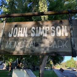
John Simpson Memorial Park
1 review