Republic Memorials Photos
More like Republic Memorials
Recommended Reviews - Republic Memorials
Start your review...

7 years ago


More info about Republic Memorials


Republic Memorials - landmarks - Updated July 2026
Best of Republic
People found Republic Memorials by searching for…
Things to Do in Republic, Michigan
Attractions in Republic, Michigan
Grave Stones in Republic, Michigan
Public Services & Government in Republic, Michigan
Scenic Overlook in Republic, Michigan
Lighthouses in Republic, Michigan
View Points in Republic, Michigan
Photo Spots in Republic, Michigan
Places to Take Pictures in Republic, Michigan
Things to See in Republic, Michigan
Night View in Republic, Michigan
Browse Articles
Browse Nearby
BEST of Republic, Michigan Parks near Republic Memorials
BEST of Republic, Michigan Restaurants near Republic Memorials
BEST of Republic, Michigan Shopping near Republic Memorials
BEST of Republic, Michigan Breakfast near Republic Memorials
BEST of Republic, Michigan Pizza near Republic Memorials
BEST of Republic, Michigan Hotels near Republic Memorials
BEST of Republic, Michigan Lakes near Republic Memorials
BEST of Republic, Michigan Campgrounds near Republic Memorials
Browse Brands
Related Searches in Republic, MI
Best Places for Stunning Views in Republic, Michigan
Discover Historic Sites and Places in Republic, Michigan
Discover Popular Photo Spots in Republic, Michigan
Discover Romantic Views in Republic, Michigan
Discover the Best Caves to Explore in Republic, Michigan
Enjoy the Best Night View Spots in Republic, Michigan
Explore Beautiful Castles and Landmarks in Republic, Michigan
Explore Popular View Points Around Republic, Michigan
Find Beautiful Views in Republic, Michigan
Find the Best Bridge Spots in Republic, Michigan
Popular Places to Take Pictures in Republic, Michigan
Popular Things to See in Republic, Michigan
Top Places to Visit in Republic, Michigan for Sightseeing
People who viewed Republic Memorials also viewed
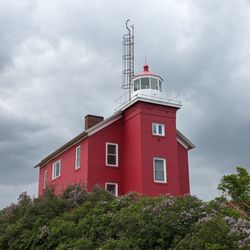
Marquette Harbor Light
5 reviews
Lower Harbor Ore Dock
2 reviews
Negaunee Post Office
1 review
Marquette Branch Prison
3 reviews
Ore Dock Brewing Company
159 reviews
$
Michigan Iron Industry Museum
4 reviews
Peter White Library
4 reviews
Negaunee Public Library
1 review
Crystal Falls Township Hall
1 review
Ishpeming Carnegie Library
1 review