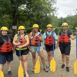
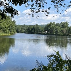
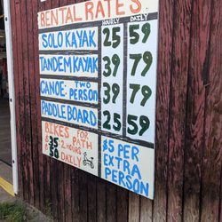
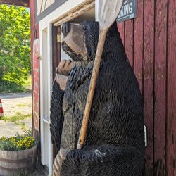
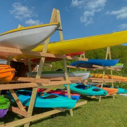
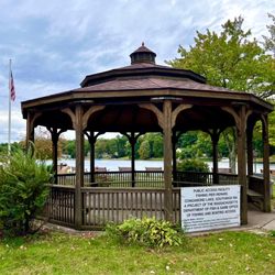
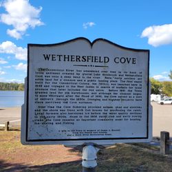
Reach Your Summit Photos


You might also consider
More like Reach Your Summit
Recommended Reviews - Reach Your Summit


More info about Reach Your Summit
Simsbury, CT 06070
Directions
(203) 695-8748
Call Now
Visit Website
http://www.reachyoursummit.net
Hours
Payment methods
Indoor Amenities
Outdoor Amenities
Other Amenities
From the Business
Ask the Community - Reach Your Summit


Reach Your Summit - hiking - Updated July 2026
Best of Simsbury
People found Reach Your Summit by searching for…
Lakes in Simsbury, Connecticut
Ski Resorts in Simsbury, Connecticut
Sunset View in Simsbury, Connecticut
Hiking Trails With Waterfalls in Simsbury, Connecticut
Campgrounds in Simsbury, Connecticut
Walking Trails in Simsbury, Connecticut
Kayak Rental in Simsbury, Connecticut
Sunrise View in Simsbury, Connecticut
Dog Friendly Trails in Simsbury, Connecticut
Beautiful Views in Simsbury, Connecticut
Cross Country Skiing in Simsbury, Connecticut
Canoe Rental in Simsbury, Connecticut
Scenic View in Simsbury, Connecticut
White Water Rafting in Simsbury, Connecticut
Outdoor Gear in Simsbury, Connecticut
Tours in Simsbury, Connecticut
Lakes & Ponds in Simsbury, Connecticut
Things to Do in Simsbury, Connecticut
Running Trails in Simsbury, Connecticut
Scenic Overlook in Simsbury, Connecticut
Fun Things to Do at Night in Simsbury, Connecticut
Off Road Trails in Simsbury, Connecticut
Trending Searches in Simsbury, CT
4th Of July Fireworks near Reach Your Summit
Black Owned Nail Salons near Reach Your Summit
Boat Rental near Reach Your Summit
Cliff Jumping near Reach Your Summit
Day Trips near Reach Your Summit
Fireworks near Reach Your Summit
Jet Ski Rental near Reach Your Summit
Kayak Rental near Reach Your Summit
Lakes & Ponds near Reach Your Summit
Mountain Biking near Reach Your Summit
Off Road Trails near Reach Your Summit
Outdoor Activities near Reach Your Summit
Parks For Picnics near Reach Your Summit
Picnic Spots near Reach Your Summit
Public Pools near Reach Your Summit
Public Shower near Reach Your Summit
River Swimming near Reach Your Summit
Rock Quarry near Reach Your Summit
Scenic Night View near Reach Your Summit
Scenic Overlook near Reach Your Summit
Secluded Spots near Reach Your Summit
Soccer Store near Reach Your Summit
Splash Pad near Reach Your Summit
Star Gazing near Reach Your Summit
Strawberry Picking near Reach Your Summit
Sunrise View near Reach Your Summit
Swimming Holes near Reach Your Summit
Swimming Lakes near Reach Your Summit
Watch Sunset near Reach Your Summit
Water Parks near Reach Your Summit
Browse Nearby
BEST of Simsbury, Connecticut Coffee near Reach Your Summit
BEST of Simsbury, Connecticut Restaurants near Reach Your Summit
BEST of Simsbury, Connecticut Things to Do near Reach Your Summit
BEST of Simsbury, Connecticut Parks near Reach Your Summit
BEST of Simsbury, Connecticut Breakfast near Reach Your Summit
BEST of Simsbury, Connecticut Museums near Reach Your Summit
Browse Brands
Related Searches in Simsbury, CT
Affordable Bike Repair Services in Simsbury, Connecticut
Affordable Bike Tune Up Services in Simsbury, Connecticut
Affordable Kayak Rental Services in Simsbury, Connecticut
Affordable Tandem Bike Rental in Simsbury, Connecticut
Best Dog Hiking Trails Around Simsbury, Connecticut
Best Fishing Locations and Guides in Simsbury, Connecticut
Best Places for Horseback Riding in Simsbury, Connecticut
Best Sledding Spots and Fun in Simsbury, Connecticut
Best Spots for Star Gazing in Simsbury, Connecticut
Best Used Bikes for Sale Near Simsbury, Connecticut
Best Waterfalls and Swimming Holes in Simsbury, Connecticut
Check Out Off Road Trails in Simsbury, Connecticut
Discover Popular Bike Tours in Simsbury, Connecticut
Discover Popular Bike Trails in Simsbury, Connecticut
Discover Scenic Waterfall Spots in Simsbury, Connecticut
Discover Top State Parks to Visit in Simsbury, Connecticut
Discover a Hiking Trail in Simsbury, Connecticut
Discover the Best Night Hike Trails in Simsbury, Connecticut
Discover the Best Running Track in Simsbury, Connecticut
Dog-Friendly Hikes With Dogs in Simsbury, Connecticut
Enjoy Exciting Mountain Biking Adventures in Simsbury, Connecticut
Enjoy Hiking Adventures in Simsbury, Connecticut
Enjoy Kayaking Adventures in Simsbury, Connecticut
Enjoy Scenic Night View Experiences in Simsbury, Connecticut
Enjoy Tent Camping Spots Around Simsbury, Connecticut
Enjoy a Beautiful Waterfall Hike in Simsbury, Connecticut
Enjoy the Best Picnic Spots and Ideas in Simsbury, Connecticut
Enjoy the Best Tubing Experiences in Simsbury, Connecticut
Enjoy the Best Walking Trails in Simsbury, Connecticut
Experience Thrilling White Water Rafting in Simsbury, Connecticut
Explore Beautiful Parks and Green Spaces in Simsbury, Connecticut
Explore Bike Rentals Throughout Simsbury, Connecticut
Explore Easy Hikes Perfect for All in Simsbury, Connecticut
Explore Electric Bikes Available in Simsbury, Connecticut
Explore Fun Activities to Do in Simsbury, Connecticut
Explore Nature Spots Around Simsbury, Connecticut
Explore Popular Campgrounds Near Simsbury, Connecticut
Explore Popular Scenic Overlook Points in Simsbury, Connecticut
Explore Scenic Lakes to Visit in Simsbury, Connecticut
Explore Secret Spots Worth Visiting in Simsbury, Connecticut
Explore the Best Beach Spots in Simsbury, Connecticut
Explore the Best Boating Spots in Simsbury, Connecticut
Explore the Best Swimming Holes Around Simsbury, Connecticut
Explore the Best Trail Options in Simsbury, Connecticut
Find Beautiful Views in Simsbury, Connecticut
Find Cheap Bike Rentals Around Simsbury, Connecticut
Find Fun Kids Activities Outdoor in Simsbury, Connecticut
Find Parks and Recreation Activities in Simsbury, Connecticut
Find Popular Ziplining Spots Around Simsbury, Connecticut
Find Top Mountain Bike Rental Options in Simsbury, Connecticut
Browse Articles
People who viewed Reach Your Summit also viewed
Rattlesnake Mountain
5 reviews
Nepaug Reservoir Trail
2 reviews
Farmington Canal Heritage Trail
5 reviews
Trout Brook Trail
4 reviews
Sessions Woods Wildlife Management Area
9 reviews
Tory's Den
1 review
Bolton Notch State Park
2 reviews
Litchfield Land Trust Hiking Trails
2 reviews
Metacomet Trail
1 review
The John McManama Nature Trail
1 review