Pando Aspen Tree Photos


More like Pando Aspen Tree
Recommended Reviews - Pando Aspen Tree
Start your review...

5 months ago
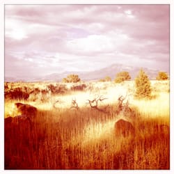
Saw this area in the fall. It was bursting with golden yellow. A lovely little side trip to see the largest living tree/organism. read more


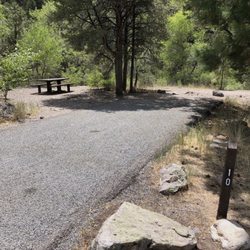
What an amazing natural wonder!! Pando is a single male Aspen clone - it spans 108 acres and has over 40,000 trunks all on one giant shared root system - one giant tree!! It weighs 6000 tons and is the heaviest known organism in the world! And if all that isn't interesting enough, the root system is estimated to be several thousand years old!! :-o Pando used to be the largest known organism in the world period - but was booted from the top spot by the discovery of the Oregon fungus mats lol. Still the heaviest though and well worth a visit. Pando is a "quaking" or trembling Aspen and is also known as The Trembling Giant. The leaves will tremble collectively, sometimes even without wind - very interesting experience!! (See my video attached to the review). You can find Pando just south of Fish Lake near Richfield Utah. There are some viewing pull-offs on the way in, small parking areas and campgrounds nearby with restrooms and a few hiking trails. Fish Lake is also a great place to explore - the whole area is just gorgeous - Highly recommend!! read more


More info about Pando Aspen Tree
100 S 167th W
Fishlake National Forest
Richfield, UT 84701
Directions
(435) 896-9233
Call Now
Hours
Outdoor Amenities
Other Amenities


Pando Aspen Tree - landmarks - Updated June 2026
Best of Richfield
People found Pando Aspen Tree by searching for…
Things to Do in Richfield, Utah
Public Shower in Richfield, Utah
Natural Hot Springs in Richfield, Utah
Hiking Trails in Richfield, Utah
Attractions in Richfield, Utah
Places to Take Pictures in Richfield, Utah
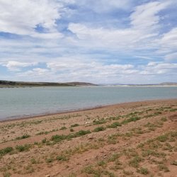
Fishing Lake in Richfield, Utah
Rv Dump Station in Richfield, Utah
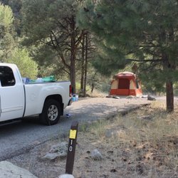
Camping Sites in Richfield, Utah
Walking Trails in Richfield, Utah
Lakes & Ponds in Richfield, Utah
Things to See in Richfield, Utah
Running Trails in Richfield, Utah
Tourist Attractions in Richfield, Utah
Cabin Rental in Richfield, Utah
National Parks in Richfield, Utah
Trending Searches in Richfield, UT
Browse Articles
Browse Brands
Related Cost Guides
Related Searches in Richfield, UT
Affordable RV Rental Options in Richfield, Utah
Best Fishing Locations and Guides in Richfield, Utah
Best Fun Things to Do in Richfield, Utah
Best Nature Trails for Hiking in Richfield, Utah
Best Places for Horseback Riding in Richfield, Utah
Best Places for Stunning Views in Richfield, Utah
Best Spots for Star Gazing in Richfield, Utah
Best Water Parks for Kids in Richfield, Utah
Best Waterfalls and Swimming Holes in Richfield, Utah
Browse Top Hotels in Richfield, Utah for Your Stay
Check Out Off Road Trails in Richfield, Utah
Discover Charming Historic Homes in Richfield, Utah
Discover Free Campgrounds in Richfield, Utah Area
Discover Popular Bike Trails in Richfield, Utah
Discover Popular Landmarks in Richfield, Utah
Discover Romantic Activities to Enjoy in Richfield, Utah
Discover Romantic Views in Richfield, Utah
Discover Scenic Creeks to Explore in Richfield, Utah
Discover Top Nature Parks to Visit in Richfield, Utah
Discover a Hiking Trail in Richfield, Utah
Discover the Best Caves to Explore in Richfield, Utah
Discover the Best Dinosaur Park Experiences in Richfield, Utah
Discover the Best Fishing Lake in Richfield, Utah
Enjoy Arts & Entertainment in Richfield, Utah
Enjoy Camping Adventures Around Richfield, Utah
Enjoy Exciting Mountain Biking Adventures in Richfield, Utah
Enjoy Hiking Adventures in Richfield, Utah
Enjoy Tent Camping Spots Around Richfield, Utah
Enjoy a Relaxing Bed & Breakfast Experience in Richfield, Utah
Enjoy the Best Night View Spots in Richfield, Utah
Enjoy the Best Picnic Spots and Ideas in Richfield, Utah
Enjoy the Best Walking Trails in Richfield, Utah
Experience Stunning Sunset Views in Richfield, Utah
Explore Beautiful Castles and Landmarks in Richfield, Utah
Explore Beautiful Parks and Green Spaces in Richfield, Utah
Explore Easy Hikes Perfect for All in Richfield, Utah
Explore Free Picnic Areas Around Richfield, Utah
Explore Hotels & Travel Options in Richfield, Utah
Explore Nature Spots Around Richfield, Utah
Explore Popular Campgrounds Near Richfield, Utah
Explore Popular Picnic Areas Around Richfield, Utah
Explore Popular RV Parks Around Richfield, Utah
Explore Popular Scenic Views Near Richfield, Utah
Explore Popular View Points Around Richfield, Utah
Explore Scenic Lakes to Visit in Richfield, Utah
Explore Scenic National Park Locations in Richfield, Utah
Explore Secret Spots Worth Visiting in Richfield, Utah
Explore Venues & Event Spaces in Richfield, Utah