Yuba State Park Photos


More like Yuba State Park
Recommended Reviews - Yuba State Park
Start your review...

Reviews With Photos


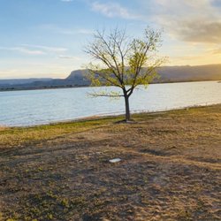
I've been to Yuba a number of times in the time that I've lived here in beautiful Utah, and Yuba is one of those places I don't mind coming back to time and time again. While I will admit, there are prettier lakes to visit here in Utah, this is one of those that get the visit because of its proximity to Utah County. I can't speak to the pay-to-enter side of Yuba Lake, as every time I've gone, my party and I have just offroaded on the Old Dam side of the lake and parked near the lakeside and had our own little slice of nature. I can only recommend this side IF you have an offroad capable vehicle. I must stress, DO NOT ATTEMPT the offroad option if you're not comfortable or don't have recovery equipment. We offroaded to the south west section of Yuba and enjoyed the day paddleboarding and swimming around. It is a great place to enjoy the water and get out of the heat for a bit. I will say though: I have noticed over the years that the water levels have gone down drastically. This shouldn't really affect your choice in going or not. If anything go for it! The experience alone will be worth it before it dries up. I've really enjoyed just going and hanging out and enjoying the weather. If you go, be prepared for the sun, bring sunscreen, but also be ready for hot weather ( if it's summer!).

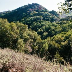
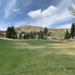
Yuba State Park is located just a few miles off the I-15 interstate near Levan Utah. It offers great opportunities for lakeside camping on the sand, boating, kayaking, fishing, ATV trails, or just kicking back and drinking a couple brews on the beach with your buddies. Yuba State Park is also quite possibly one of the best places to stargaze in the United States. I've literally never seen anything like it. The stars looked so close that you could almost reach and touch them. If you're making the 16 hour trip from Southern California to Yellowstone National Park, Yuba should be your 8 hour halfway stopping point for the night. The Northbeach campground is the closest to the highway. Reservations can be made in advance by phone or through the official website. Campsites are insanely cheap, just 10$ for the night. Many of the campgrounds closer to Salt Lake City charge upwards of 40$ per night. For travelers on a budget, you won't find a better deal than Yuba. A few words of warning: if you decide to drive on the beach, have your most experienced driver behind the wheel or YOU WILL get stuck in the sand. My girlfriend stopped to let a dog cross our path and we spent the next fifteen minutes digging and pushing the car out of the sand. As long as you keep your car in first gear, stay out of the deep stuff, and refuse to stop for anything, you should be fine. I had no trouble at all behind the wheel. :) Also, you're probably going to want to check the weather forecast. Temperatures in Yuba State Park can vary a great deal. When we visited in June, the daytime high was 89, but dipped to the low 50's at night. Pack your gear accordingly. A jacket and a heavy sleeping bag are recommended. I have a bunch of other hikes neat Yuba mapped out on my blog at http://southcaladventures.blogspot.com/2013/03/zion-bryce-grand-staircase-glen-canyon.html

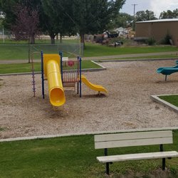
We rented the Perch Palace cabin in the Oasis Campground and were highly satisfied. It was one of two cabins they have available and it was inexpensive to rent. The two cabins are located next to each other with a fresh water spout in between. Vault bathrooms are next door, as is a path down to the lake. Deer would be feeding in the late evenings and early mornings near the path. The cabin has two queen bunk beds, a table w/ 4 chairs, a microwave, and a mini fridge. You must bring your own pillows, sheets and blankets or sleeping bags. The restrooms (showers) with plumbing are close and clean. The little store has limited items (wood, ice, beer, soda, snacks), ice cream, a grill, and recreational rentals. With covid 19 going on, the grill had very little to choose from. The bacon cheeseburger and fries were delicious, as was the fry sauce! We rented a wave runner and the rental process was fairly quick and painless. I would highly recommend bringing your own disinfectant for the cabins, especially the beds. The mattresses have zippered protectors that were stained and dusty/dirty. Some had popcorn crumbs on them. Other than that, I highly recommended!!

Wonderful place! Beautiful lake! Helpful great Rangers and seasonal staff! Amazing boating! Rangers do an amazing job keeping the water safe! As far as pervious negative reviews go let's keep one thing in mind. This is a state park. This is some place you go to enjoy nature and the beautiful lake! With nature comes bugs and dust! Let's keep our expectations in check! These r rustic cabins there will be bugs and there will be dirt! The staff have always been cleaning bathrooms when our family has been there! They r always busy with grounds work and cleaning from my observation! If u have a problem I'm sure contacting the staff and asking in a considerate manner all problems would be resolved! It's always worked for our family. Great place with great staff we will be vacationing there next year as well!

We love Yuba State Park. We have visited about 3 or 4 times now and always enjoy the quiet. We are usually early or late in the season when there are fewer people. The sites closest to the lake have wonderful views but also have wind. There are nice shelters for picnicking and a lovely beach to walk on. We love it there.

1 year ago
TOILET LEAKS: Water leaks out of toilet all over floor. If staff were cleaning the bathrooms...at any point, they would have certainly noticed the toilet leaking water all over the floors after every flush. Bathroom hasn't been cleaned in three days we've been here. Extremely dirty. No shower curtain so water floods the whole bathroom leaving floor ready to slip and fall on. I cannot recommend this facility. Drive somewhere else. Poorly managed park that could be amazing. ADDITIONALLY: My water line for the RV is 100+ feet from RV parking spot. I don't know of any RV'er who carries a 150' hose. read more


10 months ago
2 years ago
2 years ago
2 years ago
3 years ago
Very well maintained the park manager (Chesten) and his staff do a great Job, they really care about the park and it shows! read more


I've been to Yuba a number of times in the time that I've lived here in beautiful Utah, and Yuba is one of those places I don't mind coming back to time and time again. While I will admit, there are prettier lakes to visit here in Utah, this is one of those that get the visit because of its proximity to Utah County. I can't speak to the pay-to-enter side of Yuba Lake, as every time I've gone, my party and I have just offroaded on the Old Dam side of the lake and parked near the lakeside and had our own little slice of nature. I can only recommend this side IF you have an offroad capable vehicle. I must stress, DO NOT ATTEMPT the offroad option if you're not comfortable or don't have recovery equipment. We offroaded to the south west section of Yuba and enjoyed the day paddleboarding and swimming around. It is a great place to enjoy the water and get out of the heat for a bit. I will say though: I have noticed over the years that the water levels have gone down drastically. This shouldn't really affect your choice in going or not. If anything go for it! The experience alone will be worth it before it dries up. I've really enjoyed just going and hanging out and enjoying the weather. If you go, be prepared for the sun, bring sunscreen, but also be ready for hot weather ( if it's summer!). read more


3 years ago
7 years ago
13 years ago
Yuba State Park is located just a few miles off the I-15 interstate near Levan Utah. It offers great opportunities for lakeside camping on the sand, boating, kayaking, fishing, ATV trails, or just kicking back and drinking a couple brews on the beach with your buddies. Yuba State Park is also quite possibly one of the best places to stargaze in the United States. I've literally never seen anything like it. The stars looked so close that you could almost reach and touch them. If you're making the 16 hour trip from Southern California to Yellowstone National Park, Yuba should be your 8 hour halfway stopping point for the night. The Northbeach campground is the closest to the highway. Reservations can be made in advance by phone or through the official website. Campsites are insanely cheap, just 10$ for the night. Many of the campgrounds closer to Salt Lake City charge upwards of 40$ per night. For travelers on a budget, you won't find a better deal than Yuba. A few words of warning: if you decide to drive on the beach, have your most experienced driver behind the wheel or YOU WILL get stuck in the sand. My girlfriend stopped to let a dog cross our path and we spent the next fifteen minutes digging and pushing the car out of the sand. As long as you keep your car in first gear, stay out of the deep stuff, and refuse to stop for anything, you should be fine. I had no trouble at all behind the wheel. :) Also, you're probably going to want to check the weather forecast. Temperatures in Yuba State Park can vary a great deal. When we visited in June, the daytime high was 89, but dipped to the low 50's at night. Pack your gear accordingly. A jacket and a heavy sleeping bag are recommended. I have a bunch of other hikes neat Yuba mapped out on my blog at http://southcaladventures.blogspot.com/2013/03/zion-bryce-grand-staircase-glen-canyon.html read more

6 years ago
We rented the Perch Palace cabin in the Oasis Campground and were highly satisfied. It was one of two cabins they have available and it was inexpensive to rent. The two cabins are located next to each other with a fresh water spout in between. Vault bathrooms are next door, as is a path down to the lake. Deer would be feeding in the late evenings and early mornings near the path. The cabin has two queen bunk beds, a table w/ 4 chairs, a microwave, and a mini fridge. You must bring your own pillows, sheets and blankets or sleeping bags. The restrooms (showers) with plumbing are close and clean. The little store has limited items (wood, ice, beer, soda, snacks), ice cream, a grill, and recreational rentals. With covid 19 going on, the grill had very little to choose from. The bacon cheeseburger and fries were delicious, as was the fry sauce! We rented a wave runner and the rental process was fairly quick and painless. I would highly recommend bringing your own disinfectant for the cabins, especially the beds. The mattresses have zippered protectors that were stained and dusty/dirty. Some had popcorn crumbs on them. Other than that, I highly recommended!! read more


6 years ago
Wonderful place! Beautiful lake! Helpful great Rangers and seasonal staff! Amazing boating! Rangers do an amazing job keeping the water safe! As far as pervious negative reviews go let's keep one thing in mind. This is a state park. This is some place you go to enjoy nature and the beautiful lake! With nature comes bugs and dust! Let's keep our expectations in check! These r rustic cabins there will be bugs and there will be dirt! The staff have always been cleaning bathrooms when our family has been there! They r always busy with grounds work and cleaning from my observation! If u have a problem I'm sure contacting the staff and asking in a considerate manner all problems would be resolved! It's always worked for our family. Great place with great staff we will be vacationing there next year as well! read more

4 years ago
10 years ago
We love Yuba State Park. We have visited about 3 or 4 times now and always enjoy the quiet. We are usually early or late in the season when there are fewer people. The sites closest to the lake have wonderful views but also have wind. There are nice shelters for picnicking and a lovely beach to walk on. We love it there. read more


10 years ago
Yuba Lake was beautiful! Water was great! Camping site was great, camping right by the lake $10 Day pass and $16 overnight!! $10 zip lining. There's so much to do from Zip Lining, Paddle Boats, Camping, Hiking you name it. Had a great time with the family we were in the water by 8am and water was great!!! read more

13 years ago
More info about Yuba State Park
Ask the Community - Yuba State Park
Review Highlights - Yuba State Park


Why does Yelp recommend reviews?
1 review that is not currently recommended
The reviews below are not factored into the business's overall star rating.
1 year ago