Fremont Indian State Park Photos


More like Fremont Indian State Park
Recommended Reviews - Fremont Indian State Park
Start your review...

Reviews With Photos

Scenic and culturally rich experience. You can spend a few hours or several days exploring the museum, rock art and historical sites and campgrounds. Binoculars are helpful for viewing some petroglyphs. The video at the museum provides a good overview of Fremont Indians and the museum houses artifacts from the park area. Be sure to start in the museum to pick up a map of sites to visit. There are also individual trail guides you can borrow.

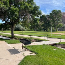
This state park is really a nice place to come to. The museum itself is very small, but there are some amazing hiking trails-that are dog friendly-that have amazing rock art on mountain sides and boulders practically at every turn. The famous Newspaper Rock is located here, and it is pretty cool to see. There are many things to see here-columnar joints, caves, hoodoos, picnic and camping areas and beautiful scenery. The museum shares space with a wonderful gift shop with many different types of items that are very reasonably priced. The woman that helped us (I wish I got her name) was an absolute delite-very funny and knowledgeable. They also offer many activities for younger children-check their schedule. Don't miss coming here! It is a real treat. Bathrooms are clean, plenty of parking and just off the freeway.
")
I visited Fremont Indian State Park to camp in our trailer in late October. The park and campgrounds were almost completely deserted, which we were extremely happy about, but we were there during the week and the nighttime temperature got down to 17 degrees (eek!), so that's likely why. Park - Bring binoculars! We were able to see many petroglyphs/pictographs with the binoculars that we wouldn't have been able to see otherwise. The interpretive walk near the visitor center, along with the Newspaper Rock site, were by far the best. But there were so many things to see, we didn't get to them all. The interpretive walk would be a great detour when on a road trip, while the other sites required some driving and hiking, which was perfect for a full day adventure. I didn't visit the museum, so I can't comment on that. Castle Rock Campground - This campground is across the highway from the visitor center and nestled in a beautiful canyon. Despite being so close to an interstate highway, you could hardly hear any traffic sounds at all. I was blown away by the peace and quiet, as I was expecting much more noise. Our site (#20, double site) was stunning. The views of the surrounding cliffs and hoodoos couldn't have been better, and the creek behind our site bathed us in soothing water sounds throughout our stay. I explored every site here, and almost all of them were incredible! The sites within the loop were much more private and had taller trees than the sites on the main road entering the grounds, so I would recommend sites in this area if privacy is what you are looking for. Sites have no hookups and there is no dump station, although we were able to sneak over to the [mostly empty] RV campground to dump before we left. Sam Stowe campground - This campground, near visitor center, was for RVs/trailers and sites had full hookups. Sites had beautiful views of the surrounding rocks but were not very private at all. The freeway noise was also quite loud. If you have an RV/trailer and do not need a full hookup, I'd highly recommend the Castle Rock campground instead. Overall - LOVED our trip here! We will definitely be back, as it's an easy drive from the SLC area.


Do you like petroglyphs? Do like short and reasonable hikes? Then Fremont Indian State Park is for you. As a solo traveler with some mobility issues, I was worried about how much access I would have to various stops on the map from the visitor center. The crew in the gift shop were delightful! They high lighted the ones I could definitely do and I did!! I loved the paved little loop at the visitor center itself that is ADA approved. My favorite was probably the 100 Hands Cave. Just a neat little walk by the creek and a small hill to get to the sight. I forgot my binoculars, so if you go bring some with you! I went on the second weekend in May, so not quite the summer season yet, so it wasn't crowded at all and I spent a couple of hours there. read more


Very nice gift shop. Great Indian art. Lots of cool educational materials and something for everyone. Also the NICEST HELPFUL staff I've ever encountered at a State Park. All staff, rangers, and camp hosts were exceptional. They were knowledgeable of the history of the area. We enjoyed the Pit House, and trails around the museum. Great place to visit. read more


Scenic and culturally rich experience. You can spend a few hours or several days exploring the museum, rock art and historical sites and campgrounds. Binoculars are helpful for viewing some petroglyphs. The video at the museum provides a good overview of Fremont Indians and the museum houses artifacts from the park area. Be sure to start in the museum to pick up a map of sites to visit. There are also individual trail guides you can borrow. read more


This state park is really a nice place to come to. The museum itself is very small, but there are some amazing hiking trails-that are dog friendly-that have amazing rock art on mountain sides and boulders practically at every turn. The famous Newspaper Rock is located here, and it is pretty cool to see. There are many things to see here-columnar joints, caves, hoodoos, picnic and camping areas and beautiful scenery. The museum shares space with a wonderful gift shop with many different types of items that are very reasonably priced. The woman that helped us (I wish I got her name) was an absolute delite-very funny and knowledgeable. They also offer many activities for younger children-check their schedule. Don't miss coming here! It is a real treat. Bathrooms are clean, plenty of parking and just off the freeway. read more


6 years ago
I visited Fremont Indian State Park to camp in our trailer in late October. The park and campgrounds were almost completely deserted, which we were extremely happy about, but we were there during the week and the nighttime temperature got down to 17 degrees (eek!), so that's likely why. Park - Bring binoculars! We were able to see many petroglyphs/pictographs with the binoculars that we wouldn't have been able to see otherwise. The interpretive walk near the visitor center, along with the Newspaper Rock site, were by far the best. But there were so many things to see, we didn't get to them all. The interpretive walk would be a great detour when on a road trip, while the other sites required some driving and hiking, which was perfect for a full day adventure. I didn't visit the museum, so I can't comment on that. Castle Rock Campground - This campground is across the highway from the visitor center and nestled in a beautiful canyon. Despite being so close to an interstate highway, you could hardly hear any traffic sounds at all. I was blown away by the peace and quiet, as I was expecting much more noise. Our site (#20, double site) was stunning. The views of the surrounding cliffs and hoodoos couldn't have been better, and the creek behind our site bathed us in soothing water sounds throughout our stay. I explored every site here, and almost all of them were incredible! The sites within the loop were much more private and had taller trees than the sites on the main road entering the grounds, so I would recommend sites in this area if privacy is what you are looking for. Sites have no hookups and there is no dump station, although we were able to sneak over to the [mostly empty] RV campground to dump before we left. Sam Stowe campground - This campground, near visitor center, was for RVs/trailers and sites had full hookups. Sites had beautiful views of the surrounding rocks but were not very private at all. The freeway noise was also quite loud. If you have an RV/trailer and do not need a full hookup, I'd highly recommend the Castle Rock campground instead. Overall - LOVED our trip here! We will definitely be back, as it's an easy drive from the SLC area. read more
 - Parks Near Me - Sevier, Utah")
 - Parks Near Me - Sevier, Utah")

 - Parks Near Me - Sevier, Utah")
9 years ago
Had so much fun we camped here and it was by far amazing So many amazing people we met and just had a blast and got so drunk and everything glad we found this little amazing spot read more

8 years ago


5 years ago
5 years ago
6 years ago
9 years ago
8 years ago
14 years ago
10 years ago
More info about Fremont Indian State Park
3820 W Clear Creek Canyon Rd
Sevier, UT 84766
Directions
(435) 527-4631
Call Now
Visit Website
http://stateparks.utah.gov/parks/fremont
Hours
Outdoor Amenities
Other Amenities
From the Business
Ask the Community - Fremont Indian State Park
Review Highlights - Fremont Indian State Park


Fremont Indian State Park - parks - Updated August 2026
Best of Sevier
People found Fremont Indian State Park by searching for…
People who viewed Fremont Indian State Park also viewed
Otter Creek State Park
1 review
Territorial Statehouse State Park Museum
6 reviews
Little Cottonwood Campground
3 reviews
Lions Park
3 reviews
Big Rock Adventure
6 reviews
Always Rafting
12 reviews
Filmore Park
2 reviews
Hillside Miniature Golf & Games
2 reviews
Paiute Trail UTVs
4 reviews
Canyon Breeze Golf Course
3 reviews