Cancel

    Open app

    Search

    Oxbow Preserve

    3.6 (5 reviews)

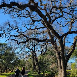
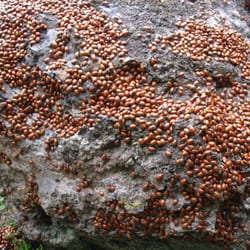
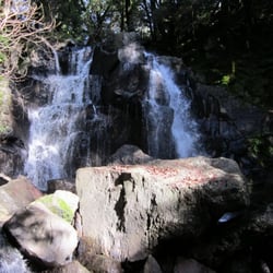
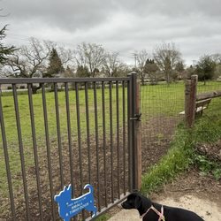
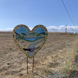
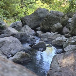
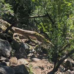
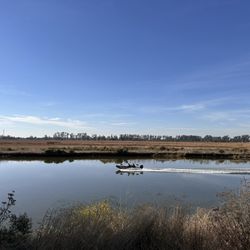
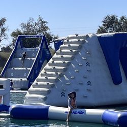
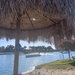
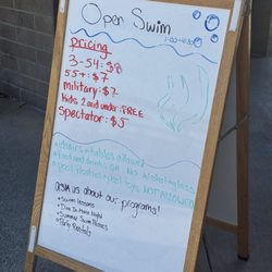
    Oxbow Preserve Photos

    You might also consider

    Recommended Reviews - Oxbow Preserve

    Your trust is our priority, so businesses can't pay to alter or remove their reviews. Learn more about reviews.
    Yelp app icon
    Browse more easily on the app
    Review Feed Illustration

    5 years ago

    Helpful 0
    Thanks 0
    Love this 0
    Oh no 0

    10 years ago

    Helpful 14
    Thanks 1
    Love this 12
    Oh no 0
    Photo of Miranda S.
    293
    42
    12

    8 years ago

    Helpful 0
    Thanks 0
    Love this 0
    Oh no 0

    6 years ago

    Helpful 1
    Thanks 0
    Love this 0
    Oh no 0
    Photo of H D.
    0
    58
    3

    7 years ago

    Awful place to take a dog. She was COVERED in foxtails by the end of our walk. And the water access is like a swamp. Total disappointment.

    Helpful 1
    Thanks 0
    Love this 1
    Oh no 0

    You might also consider

    Verify this business for free

    People searched for Parks 2,314 times last month within 15 miles of this business.

    Verify this business

    Archer Taylor Preserve - Newt 2/27/16

    Archer Taylor Preserve

    4.8(5 reviews)
    0.3 mi

    Have you been to Archer Taylor Preserve in Napa? It's pretty awesome. It's on land owned by the…read moreLand Trust of Napa County and to visit ATP you need to go on a guided hike with them at least once. I've been to ATP twice now. The first time was back in 2006, but I didn't review it back then. Went back today, Sat 1/16/10 so I could see it again & review it. We left Fmt and got to the meeting spot of the guided hike in 1hr20min. We meet in the Target's parking lot on Trancas Rd. They have 2 flush toilets w/ tp in outhouses down the hill by the picnic tables. We started hiking about 9:30am and finished about 2pm for a 7-mi loop hike. We did Maggie's Peak which is on private land. It's pretty steep, nice views on the top. Then we go down & hike on the side of the cliff, cross creeks, go down more steep & slippery rocks on not really a trail - just sides of the cliff. Saw the bottom of Devil's Well - nice waterfall, then climb a bit and see Devil's Well - you see a nice tall waterfall, and a middle waterfall that you can barely see. There's a rock scramble they call the Jumble that is a bit tough, but doable. Tons & tons of ladybugs when we went Sat 1/16/10. Ladybugs seem to like creeks & open area where they can get sun. Heading back saw a cool Hexagon rock - it's neat. Note: Leader found two ticks on her she removed after the hike!! Ticks in the area! Recommended. Website: http://napalandtrust.org/index.shtml

    Awesome place who would of thought waterfalls in Napa I recommend going after a good rain so you…read morecan experience the full force of the waterfalls. About a 4 hour hike round trip. Make reservations online and go!

    Photos
    Archer Taylor Preserve - Fungus 2/27/16 on guided hike

    Fungus 2/27/16 on guided hike

    Archer Taylor Preserve
    Archer Taylor Preserve - 2/27/16

    See all

    2/27/16

    Land Trust of Napa County - Linda Falls from the bottom

    Land Trust of Napa County

    5.0(1 review)
    0.3 mi

    I've hiked with Napa Land Trust a bunch of times & continue to hike with them when I can. My last…read morehike was Linda Falls on Sunday 1/9/11. It's a short moderate hike of about 3 miles roundtrip. To hike with them you need to plan ahead and make reservations. I booked my group of 4 about 3 weeks beforehand, but I've done it with only a few days notice. Meet the leader Chris, then we carpooled to a location she told us in Angwin. There wasn't much climbing, & only 2 rushing creeks that we had to cross - nobody fell in & I didn't even get my feet wet. That was nice. I was at the lower more dramatic falls to Linda Falls & was able to go down by following the pipe, then heading down. It was not too scary. The middle cascade up higher was nice, very top cascade wasn't much. Best to go to the bottom & look up. http://www.yelp.com/biz_photos/KjQcSZOtbG-Ev2PQaLb8TQ?select=59AxVR2wCFTnKP6ixCM0PA It's a 31 foot waterfall. Hike back was really short only about 10 minutes & we were done. Hike took 3hrs to finish from 10am-1pm. Next schedule Linda Falls hike with the Napa Land Trust is Sunday 2/13/11. Website here: http://napalandtrust.org/

    From the owner: Land Trust of Napa County is a community-based nonprofit dedicated to preserving the character of…read moreNapa by permanently protecting land. In our 44-year history, we've completed 225 projects, protecting 81,000 acres of land - 15% of Napa County.

    Photos
    Land Trust of Napa County - Side view of Linda Falls

    Side view of Linda Falls

    Land Trust of Napa County - Top of Linda Falls

    See all

    Top of Linda Falls

    Napa Valley Vine Trail - Napa Valley Vine Trail, Napa

    Napa Valley Vine Trail

    4.0(21 reviews)
    1.7 mi

    I just recently started to bike and on the look out for relatively flat, long bike trails. I'd seen…read morethis trail running parallel to Highway 29 over the years, so did some research and picked my route to start off the new year. Currently you can ride from Napa to Yountville directly with other sections (not yet all connected) up towards Calistoga and down towards Vallejo. The eventual goal is to have it run the full distance. The section I did started in Kennedy Park in Napa. Ample, free parking and restrooms are a great way to start off. The trail is very well signed once you get going and it ran an interesting path through Napa wetlands, along the Napa River, and through a bit of an industrial area with some cool murals, to start. After a little bit you're riding parallel to the Napa Wine train tracks and highway 29. There is definitely a lot of street noise but the trail is very smooth in most spots and a nice ride. As you get closer to Yountville, views of the Valley open up and you're riding through oaks and views of vineyards on either side. There are maps and informational placards along the way as well as a few benches to rest. Once in Yountville, there are restrooms in Veterans Park and it's a nice spot to have a snack and turn around. That portion, round trip ended up being 22 miles. I'm excited for the path to extend from Yountville up to Calistoga. Definitely will be back. Really well kept trail and interesting scenery along the way.

    Very fun and pretty. I walked it in a light rain and it was gorgeous. The air is just so clean up…read morehere. Highly recommend.

    Photos
    Napa Valley Vine Trail - Mural in Napa

    Mural in Napa

    Napa Valley Vine Trail - They want to make this into a 47 mile trail.

    They want to make this into a 47 mile trail.

    Napa Valley Vine Trail

    See all

    Linda Falls Preserve Hiking - Fallen tree along the path. Not a huge deal but need to hike over or around it.

    Linda Falls Preserve Hiking

    4.5(12 reviews)
    19.4 mi

    So happy to finally be able to cross this hike off my bucket list. It was certainly worth the wait…read more It's not a long hike, but there is a little bit of climbing on rocks, especially towards the end I suggest wearing good shoes with traction The scenery along the way to the falls is lovely and changes throughout the hike. Meadows, fir trees, boulders, and ponds! We made it to the Falls on the last day of April. I would think that during the summer they wouldn't be flowing as greatly as they were now. Sitting below the falls was majestic. We also did the hike at the fork of the road, which eventually ends due to all the brush on the trail, and it was lovely as well with a beautiful pond

    No signs telling you where trail is so I'm here to tell you…read more Park across the street from Pacific Union College at the far left end ball park. Walk heading North from the parking lot towards the green sign that reads bike route. You will follow that trail all the way down to the trailhead about a 1/4 mile in from the road. Once you get to the trail head you have two trails to choose from: the Linda Falls Trail or the Saw Mill Ridge Trail. We opted for the Linda Falls trail which is a 1.6 miles round trip. You will walk down a rocky path , then through a forest of trees. The trail will start to go downhill then becomes steeper as you head toward the waterfall. Going do the steep hill is where the gravel is loose and slippery. Once you get to the falls you will need to climb around the boulders to get those winning photos your friends and family will love to see on social media media. My suggestion is that you wear good trail running shoes or running shoes with good grip to the gravel as the trail can be slippery from the loose gravel. Please do not wear sandals or slippahs. Please leave your tiny dogs home unless you want to carry them over the rocks when you get closer to the waterfall. Last tip- bring water and snack to enjoy when you get to the falls. Make sure you take your trash with you. If you still have energy to go to the next trail saw Mill Ridge then head back to the trailhead you first started at. We started to head down and made it half way down until my hubby said let's turn around. I think it was his way of saying "I'm really hungry and I need to eat soon before I get hanger." Haha We plan to go back again to finish the Saw Mill Ridge Hike. This trail does have two small creeks you need to cross over. Have fun, stay on the trail , and be safe. Enjoy the pics

    Photos
    Linda Falls Preserve Hiking
    Linda Falls Preserve Hiking
    Linda Falls Preserve Hiking - Linda falls

    See all

    Linda falls

    Oxbow Preserve - parks - Updated May 2026

    Loading...
    Loading...
    Loading...