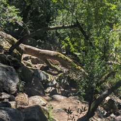
Archer Taylor Preserve Photos


You might also consider
More like Archer Taylor Preserve
Recommended Reviews - Archer Taylor Preserve
Start your review...

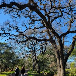
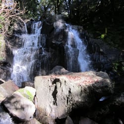
Have you been to Archer Taylor Preserve in Napa? It's pretty awesome. It's on land owned by the Land Trust of Napa County and to visit ATP you need to go on a guided hike with them at least once. I've been to ATP twice now. The first time was back in 2006, but I didn't review it back then. Went back today, Sat 1/16/10 so I could see it again & review it. We left Fmt and got to the meeting spot of the guided hike in 1hr20min. We meet in the Target's parking lot on Trancas Rd. They have 2 flush toilets w/ tp in outhouses down the hill by the picnic tables. We started hiking about 9:30am and finished about 2pm for a 7-mi loop hike. We did Maggie's Peak which is on private land. It's pretty steep, nice views on the top. Then we go down & hike on the side of the cliff, cross creeks, go down more steep & slippery rocks on not really a trail - just sides of the cliff. Saw the bottom of Devil's Well - nice waterfall, then climb a bit and see Devil's Well - you see a nice tall waterfall, and a middle waterfall that you can barely see. There's a rock scramble they call the Jumble that is a bit tough, but doable. Tons & tons of ladybugs when we went Sat 1/16/10. Ladybugs seem to like creeks & open area where they can get sun. Heading back saw a cool Hexagon rock - it's neat. Note: Leader found two ticks on her she removed after the hike!! Ticks in the area! Recommended. Website: http://napalandtrust.org/index.shtml read more


12 years ago
Awesome place who would of thought waterfalls in Napa I recommend going after a good rain so you can experience the full force of the waterfalls. About a 4 hour hike round trip. Make reservations online and go! read more

7 years ago
8 years ago
15 years ago
More info about Archer Taylor Preserve
You might also consider


Archer Taylor Preserve - hiking - Updated May 2026
Best of Napa
People found Archer Taylor Preserve by searching for…
Trending Searches in Napa, CA
Boat Rental near Archer Taylor Preserve
Botanical Gardens near Archer Taylor Preserve
Bounce House Rentals near Archer Taylor Preserve
Campgrounds near Archer Taylor Preserve
Cheap Plants near Archer Taylor Preserve
Cherry Picking near Archer Taylor Preserve
Cliff Jumping near Archer Taylor Preserve
Flower Fields near Archer Taylor Preserve
Flower Shop near Archer Taylor Preserve
Garage Sales near Archer Taylor Preserve
Garden Center near Archer Taylor Preserve
Lakes & Ponds near Archer Taylor Preserve
Nurseries & Gardening near Archer Taylor Preserve
Outdoor Activities near Archer Taylor Preserve
Outdoor Furniture Stores near Archer Taylor Preserve
Parks near Archer Taylor Preserve
Party Equipment Rentals near Archer Taylor Preserve
Pedicure near Archer Taylor Preserve
Photo Spots near Archer Taylor Preserve
Picnic Areas near Archer Taylor Preserve
Places To Take Pictures near Archer Taylor Preserve
Rock Quarry near Archer Taylor Preserve
Running Trails near Archer Taylor Preserve
Rv Rental near Archer Taylor Preserve
Scenic Drive near Archer Taylor Preserve
Sunrise View near Archer Taylor Preserve
Swimming Holes near Archer Taylor Preserve
Table And Chair Rentals near Archer Taylor Preserve
Browse Articles
Browse Nearby
BEST of Napa, California Coffee near Archer Taylor Preserve
BEST of Napa, California Restaurants near Archer Taylor Preserve
BEST of Napa, California Things to Do near Archer Taylor Preserve
BEST of Napa, California Breakfast near Archer Taylor Preserve
BEST of Napa, California Walking Trails near Archer Taylor Preserve
BEST of Napa, California Parks near Archer Taylor Preserve
BEST of Napa, California Caves near Archer Taylor Preserve
BEST of Napa, California Campgrounds near Archer Taylor Preserve
BEST of Napa, California Sightseeing near Archer Taylor Preserve
Browse Brands
Related Searches in Napa, CA
Affordable Kayak Rental Services in Napa, California
Best Fishing Locations and Guides in Napa, California
Best Nature Trails for Hiking in Napa, California
Best Places for Horseback Riding in Napa, California
Check Out Off Road Trails in Napa, California
Discover Dog Friendly Trails to Explore in Napa, California
Discover Kid Friendly Hiking Trails in Napa, California
Discover Scenic Bike Paths in Napa, California
Discover Scenic Mountain Bike Trails Near Napa, California
Discover Scenic Waterfall Spots in Napa, California
Discover Top Nature Parks to Visit in Napa, California
Discover a Hiking Trail in Napa, California
Discover the Best Night Hike Trails in Napa, California
Dog-Friendly Hikes With Dogs in Napa, California
Enjoy Camping Adventures Around Napa, California
Enjoy Exciting Mountain Biking Adventures in Napa, California
Enjoy Kayaking Adventures in Napa, California
Enjoy Tent Camping Spots Around Napa, California
Enjoy a Beautiful Waterfall Hike in Napa, California
Enjoy the Best Picnic Spots and Ideas in Napa, California
Enjoy the Best Walking Path in Napa, California
Enjoy the Best Walking Trails in Napa, California
Exciting Cliff Jumping Spots in Napa, California
Experience Thrilling White Water Rafting in Napa, California
Explore Beautiful Parks and Green Spaces in Napa, California
Explore Easy Hikes Perfect for All in Napa, California
Explore Fun Activities to Do in Napa, California
Explore Popular Campgrounds Near Napa, California
Explore the Best Beach Spots in Napa, California
Explore the Best Swimming Holes Around Napa, California
Explore the Best Trail Options in Napa, California
Family Friendly Hiking With Kids in Napa, California
Find Beautiful Views in Napa, California
Find Popular Ziplining Spots Around Napa, California
Find the Best Parks for Picnics in Napa, California
Great Places to Walk in Napa, California
Hiking Trails With Waterfalls in Napa, California
Off Leash Dog Hiking Trails in Napa, California
Plan a Scenic Drive Route Near Napa, California
Popular Outdoor Activities to Try in Napa, California
Popular Picnic Spots to Visit in Napa, California
Safe River Swimming Areas in Napa, California
Safe and Fun Parks for Kids in Napa, California
Top Climbing Spots and Gyms in Napa, California
Top Paddleboarding Activities in Napa, California
Top Running Trails to Explore in Napa, California
Top Swimming Lakes to Enjoy in Napa, California
Top Swimming Spots and Pools in Napa, California