Oswit Canyon Loop Trail Photos


You might also consider
More like Oswit Canyon Loop Trail
Recommended Reviews - Oswit Canyon Loop Trail
Start your review...

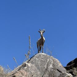
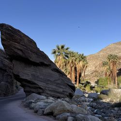
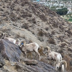
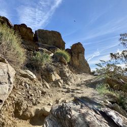
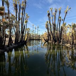
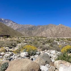
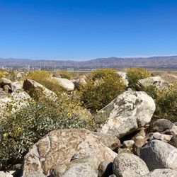
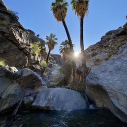
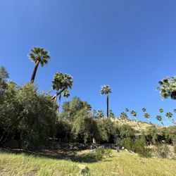
Great hike up Oswit Canyon to the waterfall with the Great Outdoors Palm Springs group. A must in the area. Great views, varied trail terrain, the scrambling was fun. Very little waterfall this time of year but a cool place to rest before turning around. While trails are marked, easy to get off track. Easy street parking. read more


More info about Oswit Canyon Loop Trail
S Palm Canyon Dr
Palm Springs, CA 92264
Directions
(760) 209-6902
Call Now
Hours
Outdoor Amenities
You might also consider


Oswit Canyon Loop Trail - hiking - Updated July 2026
Best of Palm Springs
People found Oswit Canyon Loop Trail by searching for…
Hiking Trails With Waterfalls in Palm Springs, California
Walking Trails in Palm Springs, California
Things to Do in Palm Springs, California
Waterfalls and Swimming Holes in Palm Springs, California
Easy Hikes in Palm Springs, California
Running Trails in Palm Springs, California
Beautiful Views in Palm Springs, California
Stroller Friendly Hikes in Palm Springs, California
Waterfalls in Palm Springs, California
Canyoneering in Palm Springs, California
Hiking Club in Palm Springs, California
Trails in Palm Springs, California
Scenic View in Palm Springs, California
Off Road Trails in Palm Springs, California
Hiking Groups in Palm Springs, California
Off Leash Dog Hikes in Palm Springs, California
Walking Path in Palm Springs, California
Bike Paths in Palm Springs, California
Hiking Trails Kid Friendly in Palm Springs, California
River Swimming in Palm Springs, California
Fishing Spots in Palm Springs, California
Fun in Palm Springs, California
Trending Searches in Palm Springs, CA
4th Of July Fireworks in Palm Springs, CA
Black Owned Nail Salons in Palm Springs, CA
Boat Rental in Palm Springs, CA
Cliff Jumping in Palm Springs, CA
Dog Friendly Trails in Palm Springs, CA
Jet Ski Rental in Palm Springs, CA
Kayak Rental in Palm Springs, CA
Lakes & Ponds in Palm Springs, CA
Outdoor Activities in Palm Springs, CA
Places To Walk Around in Palm Springs, CA
Public Pools in Palm Springs, CA
Public Shower in Palm Springs, CA
Rock Quarry in Palm Springs, CA
Running Trails in Palm Springs, CA
Scenic Night View in Palm Springs, CA
Scenic Overlook in Palm Springs, CA
Secluded Spots in Palm Springs, CA
Soccer Store in Palm Springs, CA
Splash Pad in Palm Springs, CA
Strawberry Picking in Palm Springs, CA
Sunrise View in Palm Springs, CA
Swimming Holes in Palm Springs, CA
Swimming Lakes in Palm Springs, CA
Swimming Pools in Palm Springs, CA
Watch Sunset in Palm Springs, CA
Browse Articles
Browse Nearby
BEST of Palm Springs, California Restaurants near Oswit Canyon Loop Trail
BEST of Palm Springs, California Things to Do near Oswit Canyon Loop Trail
BEST of Palm Springs, California Coffee near Oswit Canyon Loop Trail
BEST of Palm Springs, California Parks near Oswit Canyon Loop Trail
BEST of Palm Springs, California Breakfast near Oswit Canyon Loop Trail
BEST of Palm Springs, California Horseback Riding near Oswit Canyon Loop Trail
BEST of Palm Springs, California Ski Resorts near Oswit Canyon Loop Trail
BEST of Palm Springs, California Hot Springs near Oswit Canyon Loop Trail
Browse Brands
Related Searches in Palm Springs, CA
Best Fishing Locations and Guides in Palm Springs, California
Best Nature Trails for Hiking in Palm Springs, California
Best Places for Horseback Riding in Palm Springs, California
Best Sledding Spots and Fun in Palm Springs, California
Best Waterfalls and Swimming Holes in Palm Springs, California
Check Out Off Road Trails in Palm Springs, California
Discover Dog Friendly Trails to Explore in Palm Springs, California
Discover Kid Friendly Hiking Trails in Palm Springs, California
Discover Scenic Mountain Bike Trails Near Palm Springs, California
Discover Scenic Waterfall Spots in Palm Springs, California
Discover a Hiking Trail in Palm Springs, California
Discover the Best Night Hike Trails in Palm Springs, California
Discover the Best Running Track in Palm Springs, California
Dog-Friendly Hikes With Dogs in Palm Springs, California
Enjoy Camping Adventures Around Palm Springs, California
Enjoy Exciting Mountain Biking Adventures in Palm Springs, California
Enjoy Kayaking Adventures in Palm Springs, California
Enjoy Tent Camping Spots Around Palm Springs, California
Enjoy a Beautiful Waterfall Hike in Palm Springs, California
Enjoy the Best Walking Path in Palm Springs, California
Enjoy the Best Walking Trails in Palm Springs, California
Exciting Cliff Jumping Spots in Palm Springs, California
Explore Beautiful Parks and Green Spaces in Palm Springs, California
Explore Easy Hikes Perfect for All in Palm Springs, California
Explore Fun Activities to Do in Palm Springs, California
Explore Popular Campgrounds Near Palm Springs, California
Explore Top Dog Parks in Palm Springs, California Near You
Explore the Best Boating Spots in Palm Springs, California
Explore the Best Swimming Holes Around Palm Springs, California
Explore the Best Trail Options in Palm Springs, California
Family Friendly Hiking With Kids in Palm Springs, California
Find Beautiful Views in Palm Springs, California
Find the Best Scenic View Locations in Palm Springs, California
Great Places to Walk in Palm Springs, California
Hike the Popular Waterfall Trail in Palm Springs, California
Hiking Trails With Waterfalls in Palm Springs, California
Off Leash Dog Hiking Trails in Palm Springs, California
Plan Nature Center Visits in Palm Springs, California
Plan a Scenic Drive Route Near Palm Springs, California
Popular Fishing Spots to Explore in Palm Springs, California
Popular Outdoor Activities to Try in Palm Springs, California
Popular Picnic Spots to Visit in Palm Springs, California
Popular Things to See in Palm Springs, California
Safe River Swimming Areas in Palm Springs, California
Safe and Fun Parks for Kids in Palm Springs, California
Top Climbing Spots and Gyms in Palm Springs, California
Top Running Trails to Explore in Palm Springs, California
Top Swimming Lakes to Enjoy in Palm Springs, California
People who viewed Oswit Canyon Loop Trail also viewed
Chuckwalla Trail
5 reviews
Roadrunner Trail
8 reviews
Indio Hills Badlands Trailhead
8 reviews
Wilderness Loop Trail
6 reviews
Lykken Trail
46 reviews
Fred Wolff Bear Creek Nature Preserve
9 reviews
Willis Palms Oasis
1 review
Bighorn Overlook Trail
9 reviews
Whitewater Riverbed
7 reviews
Herb Jeffries Trailhead
1 review