Araby Trail Photos


You might also consider
More like Araby Trail
Recommended Reviews - Araby Trail
Start your review...

Reviews With Photos

Enjoyed my hike on the local Araby Trailhead, leading up to Bob and Dolores Hope's house, as well as John Johnson's. This is an easy to moderate hiking trail, where hikers, joggers, and bikers are found throughout. For the smoothest hike, ditch your sneakers for hiking shoes, and you'll manage the Earth quite masterfully. There are some steep hills to go up/down, and there are plenty of passersby to assist if you've lost your sense of direction.

My favorite hiking trail in Palm Springs, but beware of car break-ins. I was skeptical of other people writing this until I noticed all of the fresh broken glass as the trailhead dirt parking lot. Park nearby in a secure lot and keep any valuables out of sight in the trunk. I have been hiking the nearby trails in previous days but this was much more interesting. Good amount of elevation gains as well.

I love this trail. However, I just went for a sunset hike and came back to my front driver's side door shattered. Thankfully only winter coat and windbreaker was stolen and nothing more valuable. I think I got really lucky. I was only gone 40 min total. I know others have posted about this. I just didn't think it would happen to me and it did. Beware of parking at the base of the trail.


2 years ago
Nice trail to hike up, however, be sure to wear good shoes, and bring water. It's uphill and rocky. There is also loose rock, so watch your step. Parking is very limited. It can be hard on your knees coming down, but can get a pretty view from just about any distance. read more


1 year ago
4 years ago
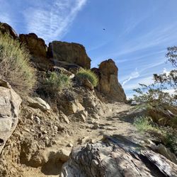
Really, really enjoyed this trail. The first mile is a bit steep and coming back may be hard on the knees as there's also a lot of loose rocks and switchbacks. After the first mile, it turns into a rolling trail with pretty vistas. I went in January and it's nice and cool in the morning with the occasional breeze but can still get fairly warm by mid afternoon. I did both the Araby and Bern trails, which totaled about 5.7 miles, and there were other trails to explore for those who want a longer hike! Side note: at the Araby trailhead, there's only parking for about 10 cars and I went on a moderately busy day and took the last remaining spot, if it could be called that since I squeezed in between a bush and another car. read more


6 years ago
Enjoyed my hike on the local Araby Trailhead, leading up to Bob and Dolores Hope's house, as well as John Johnson's. This is an easy to moderate hiking trail, where hikers, joggers, and bikers are found throughout. For the smoothest hike, ditch your sneakers for hiking shoes, and you'll manage the Earth quite masterfully. There are some steep hills to go up/down, and there are plenty of passersby to assist if you've lost your sense of direction. read more

6 years ago
My favorite hiking trail in Palm Springs, but beware of car break-ins. I was skeptical of other people writing this until I noticed all of the fresh broken glass as the trailhead dirt parking lot. Park nearby in a secure lot and keep any valuables out of sight in the trunk. I have been hiking the nearby trails in previous days but this was much more interesting. Good amount of elevation gains as well. read more

5 years ago
5 years ago
I love this trail. However, I just went for a sunset hike and came back to my front driver's side door shattered. Thankfully only winter coat and windbreaker was stolen and nothing more valuable. I think I got really lucky. I was only gone 40 min total. I know others have posted about this. I just didn't think it would happen to me and it did. Beware of parking at the base of the trail. read more


5 years ago
Good trail right off of Palm Canyon. The trail itself is moderate and has lots of options for distance depending on which routes you take. Good views of Palm Springs. I'd recommend you wear shoes with traction for the walk down. read more


6 years ago
Great trail overall, like to hike for hours and discover new trails. Never gets old! Bring lots of water in summer and a nice windbreaker in winter because it can get rough! Lots of beautiful sighs and rock formations along trails and a incline that kicks butt! So definitely try it if you haven't or been thinking about it (: a Bluetooth speaker and a few snacks for along the road recommended read more


6 years ago
More info about Araby Trail
Southridge Dr & Rim Rd
Palm Springs, CA 92264
Directions
(760) 862-9984
Call Now
Hours
Outdoor Amenities
Ask the Community - Araby Trail
You might also consider


Araby Trail - hiking - Updated May 2026
Best of Palm Springs
People found Araby Trail by searching for…
Walking Trails in Palm Springs, CA
Hiking Trails in Palm Springs, CA
Watch Sunset in Palm Springs, CA
Scenic View in Palm Springs, CA
Scenic Overlook in Palm Springs, CA
Easy Hikes in Palm Springs, CA
Beautiful Views in Palm Springs, CA
Running Trails in Palm Springs, CA
Night Hike in Palm Springs, CA
Stroller Friendly Hikes in Palm Springs, CA
Sunset View in Palm Springs, CA
Secluded Spots in Palm Springs, CA
Places to Take Pictures in Palm Springs, CA
Off Road Trails in Palm Springs, CA
Mountain Biking in Palm Springs, CA
Stairs Workout in Palm Springs, CA
Things to Do at Night in Palm Springs, CA
Canyoneering in Palm Springs, CA
Places to Walk in Palm Springs, CA
Things to Do in Palm Springs, CA
Trending Searches in Palm Springs, CA
Botanical Gardens near Araby Trail
Bounce House Rentals near Araby Trail
Cherry Picking near Araby Trail
Cliff Jumping near Araby Trail
Flower Fields near Araby Trail
Garden Center near Araby Trail
Lakes & Ponds near Araby Trail
Nurseries & Gardening near Araby Trail
Outdoor Activities near Araby Trail
Outdoor Furniture Stores near Araby Trail
Party Equipment Rentals near Araby Trail
Places To Take Pictures near Araby Trail
Running Trails near Araby Trail
Swimming Holes near Araby Trail
Browse Articles
Browse Nearby
BEST of Palm Springs, California Coffee near Araby Trail
BEST of Palm Springs, California Restaurants near Araby Trail
BEST of Palm Springs, California Walking Trails near Araby Trail
BEST of Palm Springs, California Things to Do near Araby Trail
BEST of Palm Springs, California Breakfast near Araby Trail
BEST of Palm Springs, California Parks near Araby Trail
BEST of Palm Springs, California Campgrounds near Araby Trail
BEST of Palm Springs, California Sightseeing near Araby Trail
BEST of Palm Springs, California Visitor Centers near Araby Trail
Browse Brands
Related Searches in Palm Springs, CA
Best Fishing Locations and Guides in Palm Springs, California
Best Nature Trails for Hiking in Palm Springs, California
Best Places for Horseback Riding in Palm Springs, California
Best Sledding Spots and Fun in Palm Springs, California
Best Waterfalls and Swimming Holes in Palm Springs, California
Check Out Off Road Trails in Palm Springs, California
Discover Dog Friendly Trails to Explore in Palm Springs, California
Discover Kid Friendly Hiking Trails in Palm Springs, California
Discover Scenic Mountain Bike Trails Near Palm Springs, California
Discover Scenic Waterfall Spots in Palm Springs, California
Discover a Hiking Trail in Palm Springs, California
Discover the Best Night Hike Trails in Palm Springs, California
Discover the Best Running Track in Palm Springs, California
Dog-Friendly Hikes With Dogs in Palm Springs, California
Enjoy Camping Adventures Around Palm Springs, California
Enjoy Exciting Mountain Biking Adventures in Palm Springs, California
Enjoy Kayaking Adventures in Palm Springs, California
Enjoy Tent Camping Spots Around Palm Springs, California
Enjoy a Beautiful Waterfall Hike in Palm Springs, California
Enjoy the Best Walking Path in Palm Springs, California
Enjoy the Best Walking Trails in Palm Springs, California
Exciting Cliff Jumping Spots in Palm Springs, California
Explore Beautiful Parks and Green Spaces in Palm Springs, California
Explore Easy Hikes Perfect for All in Palm Springs, California
Explore Fun Activities to Do in Palm Springs, California
Explore Popular Campgrounds Near Palm Springs, California
Explore Top Dog Parks in Palm Springs, California Near You
Explore the Best Boating Spots in Palm Springs, California
Explore the Best Swimming Holes Around Palm Springs, California
Explore the Best Trail Options in Palm Springs, California
Family Friendly Hiking With Kids in Palm Springs, California
Find Beautiful Views in Palm Springs, California
Find the Best Scenic View Locations in Palm Springs, California
Great Places to Walk in Palm Springs, California
Hike the Popular Waterfall Trail in Palm Springs, California
Hiking Trails With Waterfalls in Palm Springs, California
Off Leash Dog Hiking Trails in Palm Springs, California
Plan Nature Center Visits in Palm Springs, California
Plan a Scenic Drive Route Near Palm Springs, California
Popular Fishing Spots to Explore in Palm Springs, California
Popular Outdoor Activities to Try in Palm Springs, California
Popular Picnic Spots to Visit in Palm Springs, California
Popular Things to See in Palm Springs, California
Safe River Swimming Areas in Palm Springs, California
Safe and Fun Parks for Kids in Palm Springs, California
Top Climbing Spots and Gyms in Palm Springs, California
Top Running Trails to Explore in Palm Springs, California
Top Swimming Lakes to Enjoy in Palm Springs, California
People who viewed Araby Trail also viewed
Cactus to Clouds Hike, Mt. San Jacinto Peak
74 reviews
Bump and Grind Trail, Mike Schuler Trail Head
98 reviews
Tahquitz Canyon
249 reviews
Homestead Trail to the Cross
46 reviews
North Lykken Trail
4 reviews
Murray Hill/Peak Hiking Trail
5 reviews
Coachella Valley Preserve
121 reviews
Oswit Canyon Loop Trail
1 review
Chino Cone Alluvial Fan hike
3 reviews
Whitewater Preserve
121 reviews