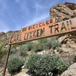
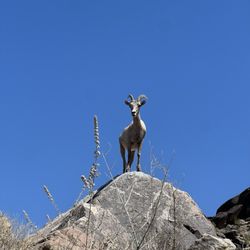
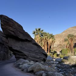
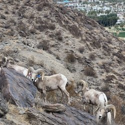
Lykken Trail Photos


You might also consider
More like Lykken Trail
Recommended Reviews - Lykken Trail
Start your review...

Reviews With Photos

I enjoy hiking and so this was one of our stops in Palm Springs. Park on the street and walk a short distance to the trailhead. Loved the group of bighorn sheep just milling about! The hike itself was good, there's elevation after the first flat part and the top is scenic. There were some picnic tables there that a group was using. Hikers on the trail were friendly and made way for us as we were ascending. Difficulty level was on the moderate-difficult side, though we took some breaks. There's no real shade relief, so keep in mind the sun will affect your experience. This is a good spot to come as it is a nice workout and there is no admission.

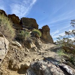
Great medium difficulty hike! Checked the box on a few different hikes in the area on the way to Joshua Tree. South Lykken was a great start to the day and free of charge! Very close to the neighboring Canyon trail with long lines of groups paying $15 a pop to hike. I would pack some quality hiking shoes as this trail zig zags up the mountain and there are some steep/jagged surfaces. Great views of Palm Springs and not too much traffic. Street parking for this hike and don't park at the reserved canyon parking or you'll get towed


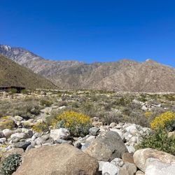
Nice, moderate to easy trail. Which ever way you decide to go it is covered in payed dirt trails, rocks, loud insects and desert plants with a back drop of the San Jacinto mountains. Its located near some housing areas and public parking is right at the beginning. Not really a picture worthy place, mostly just to get your work out on type of trail.

First time doing this trail and it was pretty nice. Unfortunately we started around 9 so it was starting to get hotter so I think that hindered how far we went. The trail can be steep or at least the path we took. It reminded us a little of Bright Angel Trail at Grand Canyon. But not as crazy just the way the trail is with some parts made into steps. Either way it looks like the trail can go pretty far and we didn't go too deep. There were other people we passed. Nothing crazy at all. Not any shade so sun screen. Of course water and I would say a back pack so some parts you can use your hands to get around. I would say start earlier or when it's cool. As far as we went , the trail itself didn't have much to look at and the view is nice looking out but compared to other trails with better views , I would say this one is more for locals who don't want to have to share the trail with many and just want to get a good exercise and hike in.

MANY BIGHORN SHEEP ON TRAIL! Best bighorn sheep experience in 30 years living in Southern California. For the right driving directions, type South Lykken Trail in Google Maps and choose the Mesquite Avenue location; Apple and Yelp do not locate the trailhead correctly. We parked on Mesquite east of Belardo, about an hour before sunset on a cloudy day in late January. The trailhead is just outside the entrance to the Tahquitz Visitor Center; do not park in their parking because your vehicle may be locked in. After 30 min of moderate hiking, we saw a whole herd of bighorn sheep on and near the trail. Several sheep within 30 feet! Grazing on fresh green growth about a month after rain. A cautious mama sheep nursed a playful lamb and kept an eye on us. Take a camera with a long lens or a phone with a good zoom. Remember to take a flashlight if you might be there after sunset

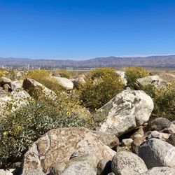
My heart didn't explode! Seriously though, this hike quickly goes from a leisurely flat hike to hiking a narrow path that zigzags up a mountain. It was a good workout. Hats off the the people who were running up the mountain. More than half the people I passed (dozens, it was busy) were using hiking sticks. Hiking stick would have been nice on the way down. There were some steep spots. The path is well defined. There is no question where the path is. I decided to only hike as far as Simonetta Kennett Vista Point. This seems to be what most other hikers were doing. The trail does keep going. This trail is not a loop. The vista has breathtaking views. It is a great location to take in a full view of Palm Springs. There are two picnic tables at Simonetta Kennett Vista Point. Talk about lunch with a view. Everything looks so small from this vantage point. Trash is pack in, pack out. The view was just one reason I chose this trail. Another reason I chose this trail was the reports of wild big horn sheep. Unfortunately, the sheep were not out the day/time I hiked. There was evidence of the animals. I just missed them. Make sure to dress in layers. On a January afternoon, it quickly went from needing a light jacket to not. There is no shade. Regardless of time of year, bring plenty of water. Parking for this trailhead is on the street, along South Palm Canyon Dr. There is a map near the street with interesting information and rules. There are no entry fees for the trail. Keep the pups, bikes, and motorcycles at home. Signs indicate no dogs, bikes, or motorcycles allowed on the trail.

want a quick hike while in Palm Springs? look no further, ... we were hoping to do other local hikes [ and although love love supporting local tribes and parks ] the prices that we found seem a bit steep... We found this trail which had was easy to get to from the street. actually really enjoyed our conversations with a couple of locals who had the logistics down of the trail... distance, elevation gains, points of interests, this was very helpful as I only look up that it was "free" but not necessarily the other details. As one local pointed out, "the picnic tables" would provide a good climb and a rewarding view once there. thats exactly what we did... not gonna lie, we were a bit winded, but glad we made it to the top! this trail does go all way to the "north" part of Palm springs so be aware and come prepare if you planning to hike the "whole thing" ! thank you again palm spring local residents for all the valuable info prior to our hike!

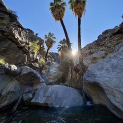
This trail is a nice workout with some great views. We came in late November, so we did not have any issues with heat. You can find parking down the street or at the visitor's center. I don't know if there is a charge for parking at the visitor's center, but that lot looked pretty full. The trail is rocky, so I recommend appropriate footwear. I wore my low boots, and I am happy I did. My wife only had running shoes. She complained about some sore feet from the rocks. The views are great! You can see the entire Palm Springs area. Once you get pretty high up, you can see a waterfall down in a valley. Take binoculars to take advantage of the views. We also saw some big horn sheep. They were only about 40 feet off the trail, so we were pretty close. Beautiful animals. They blend is very well with the plants and rocks, so keep a close eye out. People on the trail were nice. I did not see any litter. Pro tip - use the restroom before you start the hike. There are no facilities.

We have hiked the Lykken trail twice now. My daughter loves it. It does have pretty views out over Palm Springs, and it's super convenient, starting or ending right at the Palm Springs Art museum. If you start about half an hour before sunrise, you can get some beautiful sunrise views, and it's cooler, too. But still bring plenty of water. It's a little strenuous for me -- mostly uphill then downhill, not much flat in between. Not sure I'll do it a third time, but it's worth checking it out.


I absolutely love this trail! Done properly, it can be really rewarding and enjoyable. Here are a list of do's and don'ts: Do: ~Park on the street next to Mac Magruder's abandoned Chevy dealership, then head up the road to the trailhead. ~Start in the morning - NOT an afternoon hike! ~Bring water. ~Sunscreen. ~Wear sun-protective clothing, hat and sunglasses. ~Pace yourself and smile at others on the trail...a greeting is nice too :) ~Try different variations - hike up to the first tables and continue on a few miles to the other tables, do a loop, do a speed hike/run up to the first tables, etc. ~Enjoy the view and take photos! Dont's: ~Don't avoid due to rattlesnake paranoia - be cautious, but this a very well-used trail - snakes generally don't like people tramping all over the place. Also, avoid in the evening when snakes may be roaming the hillside (they are most active in the evening.) ~Don't do the opposite of my above recommendations :) Here's a Strava link to a loop I did recently: https://app.strava.com/activities/281641276 I think I prefer hiking up, across to the tables at the Simonetta Kennett vista point, then back (the road sucks as the sidewalks are not continuous.) For a short hike, park next to Mac's place and hike up to the Josie Johnson Vista Park, it's 3.9 miles, 1,143 ft. and takes roughly 1.5 hours. The highlights for me included: ~You can get a great workout if you push it. ~The views of Palm Springs are excellent. ~You can see down into Tahquitz Canyon - including the waterfall. ~Cool desert terrain - rocks, cactus, lizards and beautiful flowers in the spring. 5 stars
Was in town for Desert Air music festival and they offered a guided hike on the Oswit canyon trail as one of the dayitme "layovers." Our guides were Jannick and Dave who took us on the one mile loop hike while telling us facts and stories about the property. I haven't been to the gym or hiked as much as I'd like and found it to be doable with great views. We stopped a lot to learn about the flora and the fauna and about the non profit that saved this land from development. If you're looking for a good hike Lykken has the one mile loop as well as a north trail hike with ELEVATION! It's great if you're looking for a quick hike that will get your heart rate going or a long hike that will hit you with elevation early and get you closer to the sky. read more


1 year ago
3 months ago
4 months ago
8 months ago
I enjoy hiking and so this was one of our stops in Palm Springs. Park on the street and walk a short distance to the trailhead. Loved the group of bighorn sheep just milling about! The hike itself was good, there's elevation after the first flat part and the top is scenic. There were some picnic tables there that a group was using. Hikers on the trail were friendly and made way for us as we were ascending. Difficulty level was on the moderate-difficult side, though we took some breaks. There's no real shade relief, so keep in mind the sun will affect your experience. This is a good spot to come as it is a nice workout and there is no admission. read more


Great medium difficulty hike! Checked the box on a few different hikes in the area on the way to Joshua Tree. South Lykken was a great start to the day and free of charge! Very close to the neighboring Canyon trail with long lines of groups paying $15 a pop to hike. I would pack some quality hiking shoes as this trail zig zags up the mountain and there are some steep/jagged surfaces. Great views of Palm Springs and not too much traffic. Street parking for this hike and don't park at the reserved canyon parking or you'll get towed read more


We just did 2miles up & back to the vista but it is definitely a workout. Lots of rocks and moderate climbing not strenuous in the sections I hiked. Perfect to get out and have exercise & fabulous views! Don't forget your water read more


Nice, moderate to easy trail. Which ever way you decide to go it is covered in payed dirt trails, rocks, loud insects and desert plants with a back drop of the San Jacinto mountains. Its located near some housing areas and public parking is right at the beginning. Not really a picture worthy place, mostly just to get your work out on type of trail. read more


First time doing this trail and it was pretty nice. Unfortunately we started around 9 so it was starting to get hotter so I think that hindered how far we went. The trail can be steep or at least the path we took. It reminded us a little of Bright Angel Trail at Grand Canyon. But not as crazy just the way the trail is with some parts made into steps. Either way it looks like the trail can go pretty far and we didn't go too deep. There were other people we passed. Nothing crazy at all. Not any shade so sun screen. Of course water and I would say a back pack so some parts you can use your hands to get around. I would say start earlier or when it's cool. As far as we went , the trail itself didn't have much to look at and the view is nice looking out but compared to other trails with better views , I would say this one is more for locals who don't want to have to share the trail with many and just want to get a good exercise and hike in. read more


MANY BIGHORN SHEEP ON TRAIL! Best bighorn sheep experience in 30 years living in Southern California. For the right driving directions, type South Lykken Trail in Google Maps and choose the Mesquite Avenue location; Apple and Yelp do not locate the trailhead correctly. We parked on Mesquite east of Belardo, about an hour before sunset on a cloudy day in late January. The trailhead is just outside the entrance to the Tahquitz Visitor Center; do not park in their parking because your vehicle may be locked in. After 30 min of moderate hiking, we saw a whole herd of bighorn sheep on and near the trail. Several sheep within 30 feet! Grazing on fresh green growth about a month after rain. A cautious mama sheep nursed a playful lamb and kept an eye on us. Take a camera with a long lens or a phone with a good zoom. Remember to take a flashlight if you might be there after sunset read more


My heart didn't explode! Seriously though, this hike quickly goes from a leisurely flat hike to hiking a narrow path that zigzags up a mountain. It was a good workout. Hats off the the people who were running up the mountain. More than half the people I passed (dozens, it was busy) were using hiking sticks. Hiking stick would have been nice on the way down. There were some steep spots. The path is well defined. There is no question where the path is. I decided to only hike as far as Simonetta Kennett Vista Point. This seems to be what most other hikers were doing. The trail does keep going. This trail is not a loop. The vista has breathtaking views. It is a great location to take in a full view of Palm Springs. There are two picnic tables at Simonetta Kennett Vista Point. Talk about lunch with a view. Everything looks so small from this vantage point. Trash is pack in, pack out. The view was just one reason I chose this trail. Another reason I chose this trail was the reports of wild big horn sheep. Unfortunately, the sheep were not out the day/time I hiked. There was evidence of the animals. I just missed them. Make sure to dress in layers. On a January afternoon, it quickly went from needing a light jacket to not. There is no shade. Regardless of time of year, bring plenty of water. Parking for this trailhead is on the street, along South Palm Canyon Dr. There is a map near the street with interesting information and rules. There are no entry fees for the trail. Keep the pups, bikes, and motorcycles at home. Signs indicate no dogs, bikes, or motorcycles allowed on the trail. read more


want a quick hike while in Palm Springs? look no further, ... we were hoping to do other local hikes [ and although love love supporting local tribes and parks ] the prices that we found seem a bit steep... We found this trail which had was easy to get to from the street. actually really enjoyed our conversations with a couple of locals who had the logistics down of the trail... distance, elevation gains, points of interests, this was very helpful as I only look up that it was "free" but not necessarily the other details. As one local pointed out, "the picnic tables" would provide a good climb and a rewarding view once there. thats exactly what we did... not gonna lie, we were a bit winded, but glad we made it to the top! this trail does go all way to the "north" part of Palm springs so be aware and come prepare if you planning to hike the "whole thing" ! thank you again palm spring local residents for all the valuable info prior to our hike! read more


2 years ago
2 years ago
This trail is a nice workout with some great views. We came in late November, so we did not have any issues with heat. You can find parking down the street or at the visitor's center. I don't know if there is a charge for parking at the visitor's center, but that lot looked pretty full. The trail is rocky, so I recommend appropriate footwear. I wore my low boots, and I am happy I did. My wife only had running shoes. She complained about some sore feet from the rocks. The views are great! You can see the entire Palm Springs area. Once you get pretty high up, you can see a waterfall down in a valley. Take binoculars to take advantage of the views. We also saw some big horn sheep. They were only about 40 feet off the trail, so we were pretty close. Beautiful animals. They blend is very well with the plants and rocks, so keep a close eye out. People on the trail were nice. I did not see any litter. Pro tip - use the restroom before you start the hike. There are no facilities. read more


We have hiked the Lykken trail twice now. My daughter loves it. It does have pretty views out over Palm Springs, and it's super convenient, starting or ending right at the Palm Springs Art museum. If you start about half an hour before sunrise, you can get some beautiful sunrise views, and it's cooler, too. But still bring plenty of water. It's a little strenuous for me -- mostly uphill then downhill, not much flat in between. Not sure I'll do it a third time, but it's worth checking it out. read more


5 years ago
Really cool hike. They do not allow dogs but there is a cement walk way next to it that you can I'm sure walk your dogs. It goes through the desert just a little. But the reviews saying that they allow dogs are now wrong read more

11 years ago
I absolutely love this trail! Done properly, it can be really rewarding and enjoyable. Here are a list of do's and don'ts: Do: ~Park on the street next to Mac Magruder's abandoned Chevy dealership, then head up the road to the trailhead. ~Start in the morning - NOT an afternoon hike! ~Bring water. ~Sunscreen. ~Wear sun-protective clothing, hat and sunglasses. ~Pace yourself and smile at others on the trail...a greeting is nice too :) ~Try different variations - hike up to the first tables and continue on a few miles to the other tables, do a loop, do a speed hike/run up to the first tables, etc. ~Enjoy the view and take photos! Dont's: ~Don't avoid due to rattlesnake paranoia - be cautious, but this a very well-used trail - snakes generally don't like people tramping all over the place. Also, avoid in the evening when snakes may be roaming the hillside (they are most active in the evening.) ~Don't do the opposite of my above recommendations :) Here's a Strava link to a loop I did recently: https://app.strava.com/activities/281641276 I think I prefer hiking up, across to the tables at the Simonetta Kennett vista point, then back (the road sucks as the sidewalks are not continuous.) For a short hike, park next to Mac's place and hike up to the Josie Johnson Vista Park, it's 3.9 miles, 1,143 ft. and takes roughly 1.5 hours. The highlights for me included: ~You can get a great workout if you push it. ~The views of Palm Springs are excellent. ~You can see down into Tahquitz Canyon - including the waterfall. ~Cool desert terrain - rocks, cactus, lizards and beautiful flowers in the spring. 5 stars read more


 - Hiking Near Me - Palm Springs, California")


6 years ago
7 years ago
Nice trail. Consistent incline. Zero shade, so hike in Winter or go super early. Bring plenty of water. Encountered several others on the trail, and everyone was friendly. Easy street parking. read more


15 years ago
This is a very well maintained trail for runners and hikers. Dog friendly too! When you reach the top of the canyon there are picnic tables to relax or eat at if you bring food & drinks. Limited shade so bring sunscreen and or hats etc If you start at the north entrance at Mesquite it's a nice hour and a half running trail. It stretches parallel to South Palm Canyon and you can continue your run. Traffic is light. You can always cut this run short by just starting the run at the golf coarse near the levee. Run up to the picnic tables and then back down. read more

Tahquitz Canyon or Bust While on vacation, I'm always looking for a good hike that introduces me to the local environment, and gives me a good workout at the same time. This trail met my requirements tenfold. It was an easy walk from the hotel we were staying at, making this an convenient choice. After a night of imbibing, I was eager to clear my head and burn off some empty calories. My girlfriend wanted to sleep in, so we got a later start than normal, and arrived at the trail head at 9am. I recommend a start time of 7am, or better yet catching sunrise. We started the loop from South Lykken trailhead located on W Mesquite Ave, which was clearly marked with a sign posting rules and a handy map. We ended the journey at North Lykken trailhead located off of S Palm Canyon Dr. We began the steady incline and gained elavation rather quickly. Along the way, we ran into hikers of all ages. They all seemed happy to be there, and greeted us with smiles and pleasant exchanges. I kept inquiring about the location of the picnic tables, which are about the halfway mark. Along the route we saw lizards running all over the place! They reminded me of the geckos in Hawaii. So cute ! When we came across the deep Tahquitz Canyon, we were awe struck. Breath taking , literally! The rock formations are really spectacular and ever changing as you move forward, and we spied strange cactus, some were in bloom, along with wild flowers that defied logic. So many photo opportunities... Finally making it to the picnic tables, we took a quick breather & ate a nutritional bar and drank some water. We met a lovely couple from Vancouver BC, and talked about other hikes in the area. The sun was getting bolder so we continued on... We came across a fork in the trail and my girlfriend thought it looked like an easy way down. We took the "short cut " to Desert Riders Park. This trail leads to a park/lookout spot and continues onto to a fire road above the Cahuilla HIlls, a private hillside neighborhood. Further down the road it ended at an impassable gate (one of many ) with signs warning you of private property. We had to turn around and hike all the way back up the mountain. Mommy ! This off trail adventure added extra time onto our hike, when we were already tired and it was getting warmer. This made the 8.8 mile turn into over 10 miles. It felt like we were in the episode of the Brady Bunch when they visited the the Grand Canyon. Tired, hungry, and LOST. "Bobby ! Cindy !" We wished that we'd put some hotdogs and beans in our flashlight, we were getting hungry as the hour approached noon. Where was little Jimmy when we needed him ? Needless to say, when we finally finished the trek, we took Uber to our lunch spot instead of walking the few miles. Even with our mishap, we will definitely do this lovely hike when we return. There is zero shade on this hike. Bring plenty of water, and snacks for an energy boost. Wear sunscreen and a hat read more


7 years ago
This trail is a great workout and I prefer an afternoon evening hike as the sun sets behind the mountain early and you can escape the blazing sun. The morning sun is very intense so if I'm going to do this hike early I get up while it's still dark. It takes about two hrs to go to the top and back if you are having a stroll. If you run it it approximately 1:15. Depending on the seasons you can see cactus flowers and various desert blooms in spring. You may even see a herd of bighorn sheep. read more


I explored different sections of this trail from each of the different trailheads I saw marked on maps - and all are fairly similar so would recommend just starting at one of the places you can park on the street for free rather than pay a fee to even access the Tahquitz Canyon Visitor Center starting point - if you just want to hike. Some locals to prefer either the northern or southern trailheads but I didn't see or experience enough difference for it to matter. If you like walking up trails and/or getting a good view of what's down below, anywhere you start will work. read more


10 years ago
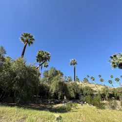
This was a fairly easy hike just off one of the main streets in southern Palm Springs. The trail begins as a leisurely stroll in the flood plain of a range of hills. You could easily spend 30-40 minutes at the base and call it a day. Or, you could continue along the sides of the hills. The peak is quite attainable for most hikers. The scenery is not as beautiful as Indian Canyons but then there is no cost for this hike. I agree with some of the other reviewers that morning is the best time to do this hike in that there is little protection from the sun. read more


9 years ago
7 years ago
Definitely a hike worth taking. Prepare days, if not weeks, in advance if at possible. Wear appropriate attire, sunscreen, and water. A hat is a great idea too. There are multiple trails to chose from. Stay to the right for an easier path or take that right turn, up that gorgeous mountain side. Good luck and enjoy. read more


8 years ago
Coming over from Phoenix I was happy to find this trail close to the hotel. Started off Mesquite. Madenthe error to go to the Canyon parking lot, was advised that I was at the wrong place. Parked on the street a few blocks away and hauled it up to the trailhead. Started at 8 am on a Friday. Passed only a couple people the whole time. Made it to the first set of picnic tables in about 30 minutes probably closer to 31. Went about 4.2 (not the whole 4.4 as I ran out of time) for 8.4 total. Maybe a little more if I count where I parked my Car. About 1600 feet of gain. Lovely trail. Will add photos. Id recommend but I imagine when crowded it wouldn't be so pleasant. I half jogged some of it where the trail would allow. I'd do it again without question. read more


12 years ago
7 years ago
12 years ago
6 years ago
7 years ago
Best time of all is late March or early April when the desert is blooming. Be alert for bees and snakes of which we encountered both but no harm. read more


10 years ago
Great hiking. My son and his friends max and cole hiked it and had the best time. Its a amazing view and great adventure for anyone with a few hours to enjoy the great outdoors. read more

Great little trail right near downtown! Parking was pretty easy on the street although the entrance was pretty hard to find (see photo I snapped of the cross streets of the entrance). It's a relatively moderate hike with some gorgeous views. Highly recommended if you're in town visiting like we were! read more


8 years ago
Page 1 of 2
More info about Lykken Trail
2923 S Palm Canyon Dr
Palm Springs, CA 92264
Directions
Hours
Indoor Amenities
Outdoor Amenities
Ask the Community - Lykken Trail
Review Highlights - Lykken Trail
You might also consider


Why does Yelp recommend reviews?
3 reviews that are not currently recommended
The reviews below are not factored into the business's overall star rating.
11 years ago
7 years ago
13 years ago
Lykken Trail - hiking - Updated May 2026
Best of Palm Springs
People found Lykken Trail by searching for…
Hiking Trails With Waterfalls in Palm Springs, CA
Dog Friendly Hiking Trails in Palm Springs, CA
Walking Trails in Palm Springs, CA
Scenic Drive in Palm Springs, CA
Watch Sunset in Palm Springs, CA
Places to Take Pictures in Palm Springs, CA
Running Trails in Palm Springs, CA
Parks for Kids in Palm Springs, CA
Night Hike in Palm Springs, CA
Off Road Trails in Palm Springs, CA
Easy Hiking Trails in Palm Springs, CA
Sunrise View in Palm Springs, CA
Picnic Areas in Palm Springs, CA
Visitor Centers in Palm Springs, CA
Scenic Night View in Palm Springs, CA
Beautiful Views in Palm Springs, CA
Dog Friendly in Palm Springs, CA
Hiking With Kids in Palm Springs, CA
Scenic Overlook in Palm Springs, CA
Dog Friendly Things to Do in Palm Springs, CA
Trending Searches in Palm Springs, CA
Botanical Gardens near Lykken Trail
Bounce House Rentals near Lykken Trail
Cherry Picking near Lykken Trail
Cliff Jumping near Lykken Trail
Dog Friendly Things To Do near Lykken Trail
Flower Fields near Lykken Trail
Garage Sales near Lykken Trail
Garden Center near Lykken Trail
Lakes & Ponds near Lykken Trail
Nurseries & Gardening near Lykken Trail
Outdoor Activities near Lykken Trail
Outdoor Furniture Stores near Lykken Trail
Party Equipment Rentals near Lykken Trail
Pick Your Own Farms near Lykken Trail
Picnic Areas near Lykken Trail
Places To Take Pictures near Lykken Trail
Running Trails near Lykken Trail
Strawberry Picking near Lykken Trail
Sunrise View near Lykken Trail
Swimming Holes near Lykken Trail
Table And Chair Rentals near Lykken Trail
Browse Articles
Browse Nearby
BEST of Palm Springs, California Things to Do near Lykken Trail
BEST of Palm Springs, California Coffee near Lykken Trail
BEST of Palm Springs, California Restaurants near Lykken Trail
BEST of Palm Springs, California Parks near Lykken Trail
BEST of Palm Springs, California Walking Trails near Lykken Trail
BEST of Palm Springs, California Campgrounds near Lykken Trail
BEST of Palm Springs, California Breakfast near Lykken Trail
Browse Brands
Related Searches in Palm Springs, CA
Best Fishing Locations and Guides in Palm Springs, California
Best Nature Trails for Hiking in Palm Springs, California
Best Places for Horseback Riding in Palm Springs, California
Best Sledding Spots and Fun in Palm Springs, California
Best Waterfalls and Swimming Holes in Palm Springs, California
Check Out Off Road Trails in Palm Springs, California
Discover Dog Friendly Trails to Explore in Palm Springs, California
Discover Kid Friendly Hiking Trails in Palm Springs, California
Discover Scenic Mountain Bike Trails Near Palm Springs, California
Discover Scenic Waterfall Spots in Palm Springs, California
Discover a Hiking Trail in Palm Springs, California
Discover the Best Night Hike Trails in Palm Springs, California
Discover the Best Running Track in Palm Springs, California
Dog-Friendly Hikes With Dogs in Palm Springs, California
Enjoy Camping Adventures Around Palm Springs, California
Enjoy Exciting Mountain Biking Adventures in Palm Springs, California
Enjoy Kayaking Adventures in Palm Springs, California
Enjoy Tent Camping Spots Around Palm Springs, California
Enjoy a Beautiful Waterfall Hike in Palm Springs, California
Enjoy the Best Walking Path in Palm Springs, California
Enjoy the Best Walking Trails in Palm Springs, California
Exciting Cliff Jumping Spots in Palm Springs, California
Explore Beautiful Parks and Green Spaces in Palm Springs, California
Explore Easy Hikes Perfect for All in Palm Springs, California
Explore Fun Activities to Do in Palm Springs, California
Explore Popular Campgrounds Near Palm Springs, California
Explore Top Dog Parks in Palm Springs, California Near You
Explore the Best Boating Spots in Palm Springs, California
Explore the Best Swimming Holes Around Palm Springs, California
Explore the Best Trail Options in Palm Springs, California
Family Friendly Hiking With Kids in Palm Springs, California
Find Beautiful Views in Palm Springs, California
Find the Best Scenic View Locations in Palm Springs, California
Great Places to Walk in Palm Springs, California
Hike the Popular Waterfall Trail in Palm Springs, California
Hiking Trails With Waterfalls in Palm Springs, California
Off Leash Dog Hiking Trails in Palm Springs, California
Plan Nature Center Visits in Palm Springs, California
Plan a Scenic Drive Route Near Palm Springs, California
Popular Fishing Spots to Explore in Palm Springs, California
Popular Outdoor Activities to Try in Palm Springs, California
Popular Picnic Spots to Visit in Palm Springs, California
Popular Things to See in Palm Springs, California
Safe River Swimming Areas in Palm Springs, California
Safe and Fun Parks for Kids in Palm Springs, California
Top Climbing Spots and Gyms in Palm Springs, California
Top Running Trails to Explore in Palm Springs, California
Top Swimming Lakes to Enjoy in Palm Springs, California
People who viewed Lykken Trail also viewed
Cactus to Clouds Hike, Mt. San Jacinto Peak
74 reviews
Tahquitz Canyon
249 reviews
North Lykken Trail
4 reviews
Murray Hill/Peak Hiking Trail
5 reviews
Bump and Grind Trail, Mike Schuler Trail Head
98 reviews
Chino Cone Alluvial Fan hike
3 reviews
Whitewater Preserve
121 reviews
Homestead Trail to the Cross
46 reviews
Swiss Canyon Trail
3 reviews
La Quinta Cove Hike
43 reviews