Osborndale State Park Photos


More like Osborndale State Park
Recommended Reviews - Osborndale State Park
Start your review...

Reviews With Photos

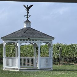
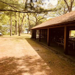
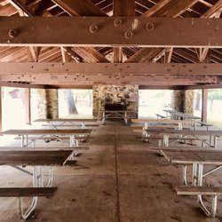
Lovely park with pavilions and a building you can rent for parties. Great hiking trails, beautiful pond and nature preserve. Clean bathrooms with flushing toilets and soap at the sinks (not always available at state parks). Plenty of parking, and everyone here seems friendly. A nice place to visit with family, and a surprise gem in the valley.

3 years ago
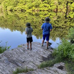
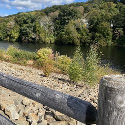
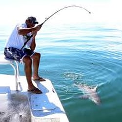
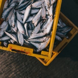
I just love this park!!! The scenery and atmosphere is just absolutely beautiful. I come into the park for my walks and to sit by lake for a few minutes to clear my mind. Osbornedale State Park has a hiking trail, fishing, picnic areas, and t nearby Osborne Homestead Museum. The prominent Osborne family owned numerous metal working and fabric product factories in the area. At the young age of 31, Frances Osborne, later Mrs. Waldo Kellogg, took over the family business when her father died in 1907. Miss Osborne decided to take over the family business instead of selling it. Additionally, it was contrary to the advice of the executers of her father's estate, and a brave undertaking for a woman in the early part of the century. Despite the prejudices against woman in business at that time, Mrs. Frances Osborne Kellogg was very successful in her many businesses and investments. By adhering to the belief that one should always buy land but never sell it. Mrs. Kellogg gradually acquired numerous separate farms which now comprise the 350 acre Osbornedale State Park, an unusually large property in the Derby-Ansonia area. read more


6 years ago
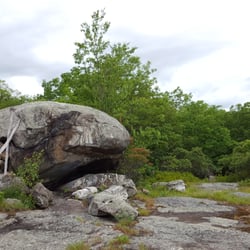
Osbornedale State Park is one of the smaller Connecticut State Parks in the system, but it still has some nice trails. This park also includes the Kellogg Environmental Center, so you get a variety of places to hike, from riverside to meadow to woods. There are also several pavilions for renting for events, so this is a nice place to have a big picnic event or kid's outdoor party. My only real complaint is that the blazing on the trails doesn't always match the maps, which can make it easy to miss a junction. read more


4 years ago
10 years ago
Lovely park with pavilions and a building you can rent for parties. Great hiking trails, beautiful pond and nature preserve. Clean bathrooms with flushing toilets and soap at the sinks (not always available at state parks). Plenty of parking, and everyone here seems friendly. A nice place to visit with family, and a surprise gem in the valley. read more

11 years ago
Nice place to go hiking or have a picnic. They have two pavilion for outdoor activities. There is a pond for fishing in the warmer weather and ice skating in the winter. Lots of trails on both sides of the park. The Osborne-Kellogg house is a museum and a environmental center. It has beautiful gardens that are well maintained. The environmental center has a history of the local area and nature exhibits. Great way to spend the day. read more


8 years ago
More info about Osborndale State Park
34 Chatfield St
Derby, CT 06418
Directions
Hours
Outdoor Amenities
Ask the Community - Osborndale State Park


Osborndale State Park - hiking - Updated June 2026
Best of Derby
People found Osborndale State Park by searching for…
Fishing Spots in Derby, Connecticut
Walking Trails in Derby, Connecticut
Things to Do in Derby, Connecticut
Picnic Areas in Derby, Connecticut
Hiking Trails in Derby, Connecticut
Crabbing Location in Derby, Connecticut
Running Trails in Derby, Connecticut
Fishing With Kids in Derby, Connecticut
Fishing Lake in Derby, Connecticut
Fun Things to Do at Night in Derby, Connecticut
Parks for Kids in Derby, Connecticut
Picnic Spots in Derby, Connecticut
Waterfalls in Derby, Connecticut
Parks for Picnics in Derby, Connecticut
Fishing Ponds in Derby, Connecticut
Scenic View in Derby, Connecticut
Lakes & Ponds in Derby, Connecticut
Live Bait Shop in Derby, Connecticut
Fishing Pier in Derby, Connecticut
Fishing Bait Shop in Derby, Connecticut
Trending Searches in Derby, CT
Bait And Tackle Shop near Osborndale State Park
Black Owned Nail Salons near Osborndale State Park
Boat Rental near Osborndale State Park
Cliff Jumping near Osborndale State Park
Crabbing Location near Osborndale State Park
Day Trips near Osborndale State Park
Dog Friendly Trails near Osborndale State Park
Fishing Charter near Osborndale State Park
Fishing Spots near Osborndale State Park
Jet Ski Rental near Osborndale State Park
Kayak Rental near Osborndale State Park
Lakes near Osborndale State Park
Lakes & Ponds near Osborndale State Park
Off Road Trails near Osborndale State Park
Outdoor Activities near Osborndale State Park
Picnic Spots near Osborndale State Park
Pontoon Boat Rentals near Osborndale State Park
Public Pools near Osborndale State Park
Public Shower near Osborndale State Park
River Swimming near Osborndale State Park
Rock Quarry near Osborndale State Park
Scenic Drive near Osborndale State Park
Scenic Night View near Osborndale State Park
Scenic Overlook near Osborndale State Park
Secluded Spots near Osborndale State Park
Soccer Store near Osborndale State Park
Splash Pad near Osborndale State Park
Strawberry Picking near Osborndale State Park
Sunrise View near Osborndale State Park
Sunset Cruise near Osborndale State Park
Swimming Holes near Osborndale State Park
Swimming Lakes near Osborndale State Park
U Pick Farms near Osborndale State Park
Watch Sunset near Osborndale State Park
Browse Nearby
BEST of Derby, Connecticut Restaurants near Osborndale State Park
BEST of Derby, Connecticut Parks near Osborndale State Park
BEST of Derby, Connecticut Coffee near Osborndale State Park
BEST of Derby, Connecticut Walking Trails near Osborndale State Park
BEST of Derby, Connecticut Things to Do near Osborndale State Park
BEST of Derby, Connecticut Breakfast near Osborndale State Park
BEST of Derby, Connecticut Taxis near Osborndale State Park
BEST of Derby, Connecticut Campgrounds near Osborndale State Park
BEST of Derby, Connecticut Lodging near Osborndale State Park
Browse Brands
Related Searches in Derby, CT
Affordable Fishing Rental Services in Derby, Connecticut
Affordable Kayak Rental Services in Derby, Connecticut
Best Crabbing Locations to Visit in Derby, Connecticut
Best Fishing Locations and Guides in Derby, Connecticut
Best Fun Things to Do in Derby, Connecticut
Best Places for Horseback Riding in Derby, Connecticut
Best Spots for Star Gazing in Derby, Connecticut
Best Waterfalls and Swimming Holes in Derby, Connecticut
Boat Services and Rentals Available in Derby, Connecticut
Book Top Fishing Trips in Derby, Connecticut Today
Check Out Off Road Trails in Derby, Connecticut
Discover Dog Friendly Trails to Explore in Derby, Connecticut
Discover Fun Activities to Do in Derby, Connecticut
Discover Lakes & Ponds to Explore in Derby, Connecticut
Discover Top Boat Tours in Derby, Connecticut for All Ages
Discover a Hiking Trail in Derby, Connecticut
Discover the Best Fishing Lake in Derby, Connecticut
Discover the Best Night Hike Trails in Derby, Connecticut
Discover the Best Sunset Cruise Tours in Derby, Connecticut
Dog-Friendly Hikes With Dogs in Derby, Connecticut
Effective Stairs Workout Spots in Derby, Connecticut
Enjoy Camping Adventures Around Derby, Connecticut
Enjoy Exciting Mountain Biking Adventures in Derby, Connecticut
Enjoy Fishing Pier Spots in Derby, Connecticut With Scenic Views
Enjoy Fishing With Kids in Derby, Connecticut Safely
Enjoy Hiking Adventures in Derby, Connecticut
Enjoy Kayaking Adventures in Derby, Connecticut
Enjoy Sailing Adventures in Derby, Connecticut
Enjoy Tent Camping Spots Around Derby, Connecticut
Enjoy Whale Watching Experiences in Derby, Connecticut
Enjoy a Beautiful Waterfall Hike in Derby, Connecticut
Enjoy a Dog Beach Day in Derby, Connecticut
Enjoy a Scenic Boat Ride in Derby, Connecticut
Enjoy the Best Tubing Experiences in Derby, Connecticut
Enjoy the Best Walking Trails in Derby, Connecticut
Exciting Cliff Jumping Spots in Derby, Connecticut
Experience Deep Sea Fishing Adventures in Derby, Connecticut
Experience Scenic Boat Cruises in Derby, Connecticut
Experience Thrilling White Water Rafting in Derby, Connecticut
Experienced Fishing Guides Available in Derby, Connecticut
Explore Beautiful Parks and Green Spaces in Derby, Connecticut
Explore Bike Rentals Throughout Derby, Connecticut
Explore Easy Hikes Perfect for All in Derby, Connecticut
Explore Fun Activities to Do in Derby, Connecticut
Explore Popular Boat Charters Near Derby, Connecticut
Explore Popular Campgrounds Near Derby, Connecticut
Explore Popular RV Parks Around Derby, Connecticut
Explore Scenic Lakes to Visit in Derby, Connecticut