Old Youth Camp Loop Photos


You might also consider
More like Old Youth Camp Loop
Recommended Reviews - Old Youth Camp Loop
Start your review...

5 years ago
It was a very hot 100 plus degree day but we decided to take this hike right before sunset. We were worried about the parking lot being locked up once it became dark. This is a easy to moderate short hike with some great views of downtown LA and the Burbank airport. When we returned to our car in the dark other people were just arriving to go on the hike, so no worries about getting your car locked in. read more
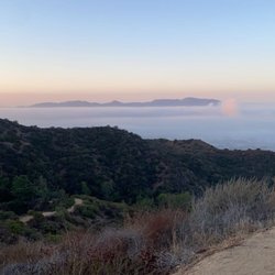
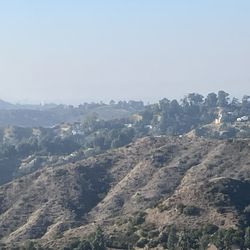
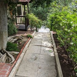
This is a short, 2.6-mile roundtrip, trail located within Verdugo Mountains. The trail offers a great work-out with its 700 feet elevation gain and some awesome views of the San Fernando Valley and beyond. At the top of the mountain you get to explore ruins of an old abandoned, and later burned down, Boy Scout camp built in the mid-20th century. The trail is a lollipop loop and the stick portion extends about half a mile up the hill. The loop starts shortly after you pass scenic spot that has a bench. You can take a sharp left (clockwise) to continue along the Old Youth Camp Trail and then Stough Canyon Trail back down to complete the loop. This gives you the best views on the way down. Alternatively, the counterclockwise direction offers a less steep incline up the mountain. The ruins are interesting to explore. There is a tall brick chimney and an outline of the former structure. It would be interesting to view an historic photo of the site. It's a good spot to rest before you make your way back down. I recommend stopping by the Nature Center before you leave. It's worth a visit. There are also bathrooms located at the Nature Center. Parking is free and the trail is dog friendly. read more


More info about Old Youth Camp Loop
2300 East Walnut Ave
Burbank, CA 91504
Directions
Hours
Outdoor Amenities
You might also consider


Old Youth Camp Loop - hiking - Updated July 2026
Best of Burbank
People found Old Youth Camp Loop by searching for…
Trending Searches in Burbank, CA
Blueberry Picking near Old Youth Camp Loop
Boat Tours near Old Youth Camp Loop
Cliff Jumping near Old Youth Camp Loop
Cruising Spots near Old Youth Camp Loop
Day Trips near Old Youth Camp Loop
Dog Friendly Things To Do near Old Youth Camp Loop
Jet Ski Rental near Old Youth Camp Loop
Kayak Rental near Old Youth Camp Loop
Kids Activities Indoor near Old Youth Camp Loop
Lakes near Old Youth Camp Loop
Off Road Trails near Old Youth Camp Loop
Outdoor Activities near Old Youth Camp Loop
Peach Picking near Old Youth Camp Loop
Places To Walk Around near Old Youth Camp Loop
Public Shower near Old Youth Camp Loop
River Swimming near Old Youth Camp Loop
Rock Quarry near Old Youth Camp Loop
Scenic Night View near Old Youth Camp Loop
Scenic Overlook near Old Youth Camp Loop
State Parks near Old Youth Camp Loop
Surf Shop near Old Youth Camp Loop
Swimming Holes near Old Youth Camp Loop
Swimming Lakes near Old Youth Camp Loop
Things To Do On A Rainy Day near Old Youth Camp Loop
Tubing near Old Youth Camp Loop
Watch Sunset near Old Youth Camp Loop
Browse Articles
Browse Nearby
BEST of Burbank, California Coffee near Old Youth Camp Loop
BEST of Burbank, California Restaurants near Old Youth Camp Loop
BEST of Burbank, California Things to Do near Old Youth Camp Loop
BEST of Burbank, California Breakfast near Old Youth Camp Loop
BEST of Burbank, California Walking Trails near Old Youth Camp Loop
BEST of Burbank, California Parks near Old Youth Camp Loop
BEST of Burbank, California Campgrounds near Old Youth Camp Loop
BEST of Burbank, California Airport near Old Youth Camp Loop
Browse Brands
Related Searches in Burbank, CA
Best Dog Hiking Trails Around Burbank, California
Best Fishing Locations and Guides in Burbank, California
Best Nature Trails for Hiking in Burbank, California
Best Places for Horseback Riding in Burbank, California
Check Out Off Road Trails in Burbank, California
Discover Dog Friendly Trails to Explore in Burbank, California
Discover Easy Hiking Trails Near Burbank, California
Discover Kid Friendly Hiking Trails in Burbank, California
Discover Popular Bike Trails in Burbank, California
Discover Scenic Mountain Bike Trails Near Burbank, California
Discover Walking Parks in Burbank, California Near You
Discover a Hiking Trail in Burbank, California
Discover the Best Night Hike Trails in Burbank, California
Dog-Friendly Hikes With Dogs in Burbank, California
Enjoy Camping Adventures Around Burbank, California
Enjoy Kayaking Adventures in Burbank, California
Enjoy Off Leash Dog Hikes in Burbank, California
Enjoy Scenic Places to Walk in Burbank, California
Enjoy a Beautiful Waterfall Hike in Burbank, California
Enjoy the Best Walking Path in Burbank, California
Enjoy the Best Walking Trails in Burbank, California
Explore Beautiful Parks and Green Spaces in Burbank, California
Explore Easy Hikes Perfect for All in Burbank, California
Explore Fun Activities to Do in Burbank, California
Explore Popular Campgrounds Near Burbank, California
Explore Popular Dog Walking Trails in Burbank, California
Explore Top Dog Parks in Burbank, California Near You
Explore the Best Beach Spots in Burbank, California
Family Friendly Hiking With Kids in Burbank, California
Find Beautiful Views in Burbank, California
Find Parks and Recreation Activities in Burbank, California
Find Top Dog Friendly Parks to Visit in Burbank, California
Find Top-Rated Waterfalls in Burbank, California Now
Find the Best Parks for Picnics in Burbank, California
Hiking Trails With Waterfalls in Burbank, California
Off Leash Dog Hiking Trails in Burbank, California
Popular Outdoor Activities to Try in Burbank, California
Popular Picnic Spots to Visit in Burbank, California
Popular Waterfall Hiking Trails in Burbank, California
Safe River Swimming Areas in Burbank, California
Safe and Fun Parks for Kids in Burbank, California
Top Hiking Trails to Explore in Burbank, California
Top Playgrounds for Kids to Enjoy in Burbank, California
Top Running Trails to Explore in Burbank, California
Top Swimming Lakes to Enjoy in Burbank, California
Top Swimming Spots and Pools in Burbank, California
Top-Rated Camping Sites in Burbank, California