Observation Point Photos


You might also consider
More like Observation Point
Recommended Reviews - Observation Point
Start your review...

Reviews With Photos

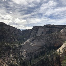
I don't think I even need to write about Observation Point. Just take a look at the pictures here. You do know that there is more than one way to hike to the Point, right? Those Weeping Rock and East Rim Trails do look awesome, and I'd love to hike them someday, but my wife, friends, and I decided for the trail less taken, namely the East Mesa Trail, for the following reasons: - We were staying in Orderville, only 30 minutes from the trailhead. - Fellow hikers are cool, but we wanted to be able to enjoy nature without so many other people around. - Although we recognize its necessity, we don't enjoy taking the park shuttle! Need directions? Here you go: http://www.citrusmilo.com/zionguide/eastmesatrail.cfm (No, this is not my website.) Tip: Although I highly recommend getting a week pass for Zion, there is no charge for accessing the park via the East Mesa Trail. This hike was pretty easy, fun, and scenic in its own way. Of course, the view at the Point was spectacular. Any way you get to it, it is not to be missed. Bring water! Wear sunscreen! "Leave nothing but footprints. Take nothing but photos. Kill nothing but time. Keep nothing but memories."

This place has an amazing view, highly recommend to take some pictures and enjoy the view. It was a pretty easy hike probably a mile or so long (depending how far you want to go). Like I said the view is amazing and along the way you might be lucky enough to see some rams hanging out on a cliff. Very cool place and view!

One of our favorite hikes while in Zion. The views from the top are amazing and awe inspiring. Bring binoculars ...so much to see and fun to look acrosss at the other trails and hikers. We came during June 2020 and during COVID - we were fortunate that weather was fair (in the 80s) and relatively few hikers. One suggestion...since the entrance to Zion was exceedingly crowded and parking was scarce we opted to access the Observation Point hike from OUTSIDE the park which was a huge positive. You can get to it at a trailhead near the Zion Ponderosa Ranch Resort and you can park near trailhead. The hike is gorgeous and you can do it in three hours round trip (about six miles total). Great way to get in an amazing hike when Park is overly crowded. Gorgeous views and good strenuous hike.

Was once amazing.... now- CLOSED! (Only giving 1 Star to make sure people will see and it plan there trip for what was once a glorious view) Observation Point and Hidden Canyon Hikes all closed - Rock slide Oct 2018 took out all trails :( Buses won't even stop at the bus stop. Closed 10/18 and as of 10/5/19 not open with no reopen date in sight.

8 miles round trip with 2,000 feet elevation gain, this may be the most beautiful trail at Zion National Park. Start with lots of switch backs, most of elevation gain is at the beginning. I had two layers of jackets and it didn't take too long before I had to take off both of them. Towards the end of initial switch backs, you will see Angel's landing and river looks like horseshoe. Pictures came out better in mid day when the Sun is up high. Early in the morning creates shadows. Echo Canyon was beautiful, so pretty. It was in the shade, I had to get my jacket back on. Then became kind of non spectacular for a while. Shortly after that, I noticed so many flowers and plants are growing from the wall. Looking around how the nature is surviving under harsh conditions was very interesting. View from the top is amazingly gorgeous. You see the Angel's landing so close, I was thinking did I really walk that ridge? That looks scary from distance. If you start early in the morning, not many people is there and was so peaceful for a while. If you want your pictures without shadows, wait until mid day for better pictures. Overall it was about 4 1/2 hours or so. The paper said strenuous but I thought it wasn't bad at all, it didn't quite give me the workout I hoped. I enjoyed different views throughout the 8 miles hike.

Amazing hike. It has a better view than Angel's Landing I think since it is higher up. Be prepared to hike a good amount of time. It is not a hard hike and not that scary. Bring water, wear a hat and shades, and wear hiking shoes You don't want to slip off the trail. Bring a picnic to enjoy at the top. On the way to Observation Point you can make a detour to Hidden Canyon. This one can be a bit scary.

A really underrated hike in my opinion! The view at the apex of the hike is amazing and scenic. Even the trail towards the top is scenic on its own. Got there in the early AM and took a good 2-3 hours with a few stops to get to the top. The view is spectacular and worth it. Take lots of water, snackage, and a good positive attitude and you're set! Bring your camera and a smile. It can get a bit crowded at the top but not as crowded as Angel's Landing. Do yourself a favor and come hike! Spend a good chunk of the day here and enjoy nature views at their finest!

When angels landing and the narrows are super busy you should head on over to Observation Point trail instead. Or, if you have done Angels Landing and The Narrows, Observation point should be your next hike inside of Zion National Park. The hiking trail is a 8 miles roundtrip hike which includes switchbacks and a beautiful trek into the canyon. I urge you to begin this trail early as currently we are in summer and it is very hot by noon. Once you reach the peak you will be amazed at how much higher in elevation you are versus Angels Landing. Keep in mind this trail does not have as many switch backs as Angels Landing does but make sure to bring a lot of water and a snack to munch on once you reach the top. Also, at the top you will be greeted by a lot of chipmunks. They are friendly.


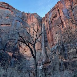
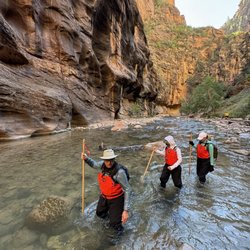
Tired of all those folks boasting about their Angel landing hike? Well do the Observation Point hike, and you can look down on them, and thumb your nose at them at the same time. Literally. I start out at 4200 feet elevation on the Zion Canyon floor at 10am on a cool April morning. Like a lot of hikes from the floor of the Canyon, this hike has little cover, lots of switchbacks, and is going up under strenuous conditions, and then hiking back down. The first three quarters of a mile is all work, going seemingly straight up the cliff on the long innumerable switchbacks, over broken concrete and rocks. You reach a fork in the trail, at 4700 feet elevation, with the right going to Hidden Canyon, and the left fork going to Observation Point. 500 elevation gain in about 3/4 mile! The Observation Point trail continues up on long traverses up the side of the mountain, dirt trails, no cover except that it is in the shade in the morning. You do not want to do this hike in the summer, otherwise you risk becoming a permanent resident - a deceased resident! Bring a hat and plenty of liquids -I only needed two 20 ounce bottles of water, but then it was cool, with highs in the low 70s. Hiking poles would help on this hike -can't use the hiking poles on the Angel landing hike, if you are going to be pulling yourself up with the chain cables on the mountain side. At the top after the first series of switchbacks, one enters Echo canyon, with a straight path alongside a river gorge, although this gorge is for the most part dried up. There is one place where there is water, deep inside the narrow canyon, where Zion adventures suited people try out their wet equipment. We reach 5600 feet elevation, a 1300 foot elevation gain, before we encounter another set of switchbacks. Yellow colored Navajo sandstone, and then orange colored sandstone on the walls of the mountain sides of the dirt trails. Sparse forests, with tall cliffs surrounding in the distance. It is here, that one encounters narrow trails, with long steep drop-offs. The trick is to never go too close to the edge, and never look down. One reaches a plateau, where one can actually see Observation Point a mile away, a white cliff, stained red with water streaks running down the cliff. First dirt, and finally sand, as one approaches the end of the hike at 6507 feet elevation, after 3.5 hours of hiking. The last 100-200 yards is all red clay, with forests of green trees. Dozens of people here, with grandiose views of Zion Canyon, with the Virgin river meandering through the canyon, and of Angel Landing some 700 feet below, and off in a distance. You can see the entire half mile of the ridge to that trail, but can't make out the people holding for their dear lives onto the chain cables in that hike. Permanent residents these squirrels running around, but don't let them climb onto you -their claws will rip your clothes and skin to shreds. Coming down is easier than going up, but hard on the knee joints. Even at 3pm I was seeing people in the first half of the hike coming up. Don't want to stick around here when the daylight retreats around 7pm -imagine going down the trail alongside the long drop-offs in the darkness! Better hope for a full moon! I reach the trailhead and the free shuttle at 430pm, after 6 hours of hiking, 8 miles, 2148 feet of elevation gain. My knee joints are in pain going the last steps downhill, but kept at it, with the encouragement of people 40 years younger! .

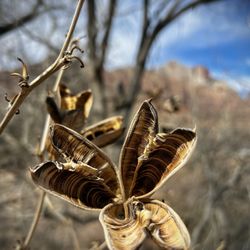
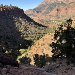
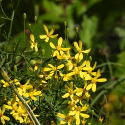
Definitely 5 stars for this hike! It's challenging with quite a few steep inclines, but the change in landscape and geology is along the way is very impressive, and you get a stellar view of Zion Canyon at the top of an approximately 2,100 ft climb (nearly 7,000 ft above sea level!). The hike to Observation Point starts at stop #7 in the Zion Canyon shuttle. It took me about 2.5 miles on the way up (with many short stops along the way for water and photos), and a little less than 2 hours for the way back down. The hike starts off with steep switchback inclines on the face of a mountain, but after about 1.5 miles, the path levels off in a canyon-like region with towering canyon walls in both sides of you. You then emerge on the other side of the mountain and it's a totally different landscape. You go up some more inclines (it is steep for quite awhile), you pass by these amazingly different colored rocks, and for the last 3/4 of a mile, it is finally flat as you cross the top of the mesa onto Observation Point. Be on the lookout for flowers, chipmunks, and geckos along the way! There are fewer hikers on this trail (compared to say, Angel's Landing), but everyone we passed was very encouraging in helping us get up some steep inclines! You get some GREAT views at the top, and you can either squint or use binoculars to see the hikers and chains of Angel's Landing. You're approximately 500 ft above Angel's Landing and it doesn't seem so intimidating! Several people at the top asked me whether I thought this hike or Angel's Landing was better...I think they are very different hikes -- both strenuous and with great views at the top, but I think Angel's Landing is perhaps more iconic (and crowded), while the landscape changes along the Observation Point hike were very unique and memorable.

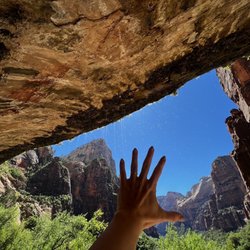
#32/100 yelp challenge - Moderate to strenuous hike - length: 2 mile round trip - duration: 1 hour ; depends on your pace and some play time. - not paved. Some narrow and drop off... - Not good for small children and handicap. - you don't need hiking sticks here - wear good hiking shoes since there are some rocky and slippery areas - very hot during summer, so you will need minimal 24 oz bottle water per person. You can not take the shuttle to this hike. We drove to the park. Once we passed the canyon junction, turned right to the SR 9 to the tunnel. It was about 6-7 miles up hill with nice view along the way, 1 mile through the tunnels. There are 2 small parkings each on the opposite direction right outside of the tunnel exit. The trail entrance is on the coming in direction. We went here at mid day so it is very hot but there are plenty of parkings. The beggining park is stairs and uphill. Continues for about half mile when you see the tree with tortuous exposed root crossing the trail, you are about half way to the overlook. Then pass the open cave, you are less than 1/4 mile to the top. From there, the trail becomes narrow only fit one person at the time, no rail, along the cliff wall. The view from the top is very nice of the winding road and many peaks. There are many wildlife up here. We saw many chipmonks and a small snake but did not see any ram.
Let me just say that this was absolutely the most incredible hike I've ever been on. Everything about it was perfect. It was difficult, but not dangerous. It had a ton of diversity in terms of the areas that you're hiking and the views you get along the way. There are valleys, towering cliff walls, trenches, and then open expansive views. All will take your breath away. The view at the end was absolutely magnificent. The best view I've ever seen in my life. The pictures look great but fail to capture the magnitude and beauty that seeing it in person do. It also wasn't that packed. Nothing like Angels Landing. I'd definitely recommend this to anyone, it's for sure worth your time. Going on this hike will give you a new appreciation for nature. At least, it did for me. Anyways, if you're going to Zion, put this on your must do list. That's all I've got here, thanks for reading (yes I view myself as a famous yelp blogger), goodbye everyone.

Wow, I love this trail! At 46, average fitness level & not exactly an avid hiker, Observation Point was definitely challenging for me - but it was totally worth it. The view from the top is, admittedly, amazing. But you're rewarded throughout this hike with all kinds of awe-inspiring scenery. The trail head is at the Weeping Rock shuttle stop; there are restrooms but no water filling station, so be sure to fill your water bottles at the Visitors' Center before boarding the shuttle. The trail starts with relatively steep switchbacks cut into the canyon wall, but it's so well maintained at this section that it's really not too bad. I just took my time & admired the surroundings. (But don't burn up your battery taking pics; it gets so much better.) By the end of this first section, you'll have gained about 1,000 feet in elevation & you'll be looking down on Angel's Landing. Next you'll go around the corner to the right & you're in another world, approaching Echo Canyon. This trail is like that, it changes dramatically at least four times. As you enter Echo Canyon, you've gone about one mile. The slot canyon is beautiful; it's a little flatter & cooler - a nice break! As you emerge from the slot, you're in the more open Upper Echo Canyon, surrounded by red Navajo sandstone. As the trail climbs higher, you'll notice that the trail change again; the red sandstone yields to lighter stone and some evergreens. When you see the sign for the East Rim Trail, there's good news and bad news. The good news is you're almost half-way there. The bad news is this is where the trail begins the relentless climb to the top. The final three, long switchbacks are cut into the white rock cliff face above Zion Canyon. On the last of these was the only place I was really nervous. Don't get me wrong, there's plenty of space, but I just got scared for some reason. (I'll post a pic of this switchback.) At the top of the white rock cliff, you're finally done climbing! The last mile (maybe a bit less) is pretty flat. There are a couple of side trails here before you reach Observation Point, in case Mother Nature calls. It's a good place to stop before you head down too. You're super close now, the hard part is over! Have fun! Tips that kept me off the Struggle Bus: *Start early. *Wear good hiking shoes/boot (obviously), layers, hat, sunglasses, sunscreen. *Have plenty of water and snacks. Electrolyte tabs to add to the water are helpful too. *A hiking staff was very helpful for me, especially on the way down. * Rest & drink water often. read more


11 years ago
This is a BRUTAL 8 mile hike, with quick elevation gain, and never ending switchbacks. Start as early as possible, because there isn't a lot of shade along the trail. Use hiking poles if you can, because this was pretty tough on our knees, especially during the descent. We liked that it was a lot less crowded than hiking to Angel's Landing, and the view at the top is incredible. read more


9 years ago
Favorite hike in Zion. Best views as you can see the valley and angels landing down below. About 8.5 miles 2,300 ft in elevation gain so definitely begin early and plan for 5-7 hours at a good pace. This starts fairly strenuous with much elevation gain and switchbacks. Eventually you'll get to a canyon that's nice and cool and then you'll begin the elevation gain again. Once at the top there's about half a mile of no elevation gain until the end. If you're doing this in the summer, a lot of the trail is shaded so the heat won't be too much of a problem. In the winter prepare for snow on the whole trail, definitely bring snow gear as the hike gets atleast twice as hard. Beautiful the whole way, definitely recommend doing! read more


11 years ago
10 years ago
This hike is an 8 mile rd,, it's a bit of a work out,, but definitely doable for anybody that isn't athletic like myself,, it's breathtaking once you get to the top,, I highly recommend this hike :) read more


11 years ago
Great hike with lots of elevation gain, 2,200 feet or so, total hike length is about 8-9 miles round trip. Took us about 4 hours to complete round trip hike plus one hour at top to enjoy lunch and views (total of 5 hours). Take Zion Park shuttle to Weeping Rock trailhead and follow trail signs. There are some spots along trail where drop offs are very steep but trail is wide, so I felt pretty safe. The walk through Echo Canyon is a nice welcome flat stroll mid-way through the hike. Also, not as crowded if compared to Angels Landing. Hiking in April in Zion is great, weather is cool and wild flowers are blooming. read more


8 years ago
This is a 8 Mike hike, 2200 elevation gain hike. It is a difficult hike, but great view of zion valley from the top. You can see down on angels landing. I heard this hike is much less scary than angels landing which seems very dangerous. I managed fairly well... took 4 hours with a 20 minute break on top. This was my first difficult hike i have completed. My legs got tired, but we took breaks along the way. Take 2 liters of water for each person, hiking shoes and go in the morning so it is cooler. It was 101 degrees during the day....hot! Part of the hike is in the sun...i wore a hat. The ground is not even so step carefully, there are sheer drop offs a lot of the way. There were quite a few people going up the hike, but not real crowded. I would not take children...too dangerous. read more


8 years ago
9 years ago
13 years ago
9 years ago
This was my first hike in Zion and the view on the top is so worth the hike! We went in the afternoon on early May and it was pretty warm out and the trail wasn't too overly crowded. On the way down we didn't really see anyone else. Saw chipmunks and deer while on this hike! I thought it was a difficult hike but not impossible! It took my husband and I a little over 3 hours to hike there and back. The top offers what I think is the best view in the park. Take lots of water and take your time. The reward is worth the effort! read more


11 years ago
10 years ago
Page 2 of 2
More info about Observation Point
Zion National Park
Springdale, UT 84767
Directions
Hours
Outdoor Amenities
Ask the Community - Observation Point
Review Highlights - Observation Point


Observation Point - hiking - Updated May 2026
Best of Springdale
People found Observation Point by searching for…
Things to Do in Springdale, Utah
Scenic Drive in Springdale, Utah
Swimming Holes in Springdale, Utah
Photo Spots in Springdale, Utah
Hiking Trails in Springdale, Utah
Rock Climbing in Springdale, Utah
Canyoneering in Springdale, Utah
Playgrounds in Springdale, Utah
Scenic Overlook in Springdale, Utah
Visitor Centers in Springdale, Utah
Hiking With Kids in Springdale, Utah
Secret Spots in Springdale, Utah
Scenic Night View in Springdale, Utah
Fishing Spots in Springdale, Utah
Hiking Trails Kid Friendly in Springdale, Utah
Night Hike in Springdale, Utah
Natural Hot Springs in Springdale, Utah
Walking Trails in Springdale, Utah
Easy Hikes in Springdale, Utah
Trending Searches in Springdale, UT
Baseball Fields near Observation Point
Bounce House Rentals near Observation Point
Campgrounds near Observation Point
Cliff Jumping near Observation Point
Dog Friendly Trails near Observation Point
Flower Shop near Observation Point
Mexican Catering near Observation Point
Mountain Bike Trails near Observation Point
Nurseries & Gardening near Observation Point
Party Equipment Rentals near Observation Point
Pedicure near Observation Point
Photo Spots near Observation Point
Picnic Areas near Observation Point
Plant Nursery near Observation Point
Running Trails near Observation Point
Rv Rental near Observation Point
Scenic Drive near Observation Point
Sunrise View near Observation Point
Browse Articles
Browse Nearby
Browse Brands
Related Searches in Springdale, UT
Best Fishing Locations and Guides in Springdale, Utah
Best Places for Horseback Riding in Springdale, Utah
Best Sledding Spots and Fun in Springdale, Utah
Best Waterfalls and Swimming Holes in Springdale, Utah
Check Out Off Road Trails in Springdale, Utah
Discover Dog Friendly Trails to Explore in Springdale, Utah
Discover Kid Friendly Hiking Trails in Springdale, Utah
Discover Popular Bike Trails in Springdale, Utah
Discover Scenic Mountain Bike Trails Near Springdale, Utah
Discover Top Boat Tours in Springdale, Utah for All Ages
Discover Top State Parks to Visit in Springdale, Utah
Discover a Hiking Trail in Springdale, Utah
Enjoy Camping Adventures Around Springdale, Utah
Enjoy Kayaking Adventures in Springdale, Utah
Enjoy Tent Camping Spots Around Springdale, Utah
Enjoy the Best Family Activities in Springdale, Utah
Enjoy the Best Tubing Experiences in Springdale, Utah
Enjoy the Best Walking Trails in Springdale, Utah
Explore Beautiful Parks and Green Spaces in Springdale, Utah
Explore Bike Rentals Throughout Springdale, Utah
Explore Easy Hikes Perfect for All in Springdale, Utah
Explore Free Things to Do Around Springdale, Utah
Explore Fun Activities to Do in Springdale, Utah
Explore Popular Campgrounds Near Springdale, Utah
Explore Popular RV Parks Around Springdale, Utah
Explore Scenic Lakes to Visit in Springdale, Utah
Explore Top Dog Parks in Springdale, Utah Near You
Explore Top Water Parks in Springdale, Utah Today
Explore the Best Boating Spots in Springdale, Utah
Explore the Best Swimming Holes Around Springdale, Utah
Explore the Best Trail Options in Springdale, Utah
Find Popular Ziplining Spots Around Springdale, Utah
Find the Best Playgrounds to Visit in Springdale, Utah
Find the Best Scenic View Locations in Springdale, Utah
Hiking Trails With Waterfalls in Springdale, Utah
Perfect Spots to Watch Sunset in Springdale, Utah
Plan a Scenic Drive Route Near Springdale, Utah
Popular Kids Activities in Springdale, Utah
Popular Outdoor Activities to Try in Springdale, Utah
Popular Things to Do in Springdale, Utah
Popular Things to See in Springdale, Utah
Safe River Swimming Areas in Springdale, Utah
Safe and Fun Parks for Kids in Springdale, Utah
Top Climbing Spots and Gyms in Springdale, Utah
Top Playgrounds for Kids to Enjoy in Springdale, Utah
Top Running Trails to Explore in Springdale, Utah
Top Swimming Lakes to Enjoy in Springdale, Utah
Top Swimming Spots and Pools in Springdale, Utah