Neversink River Unique Area Photos


More like Neversink River Unique Area
Recommended Reviews - Neversink River Unique Area
Start your review...



3 years ago
This is a beautiful hike. Worth taking the trip, hiking boots are a must, as trails have some slippery/muddy spaces. Super fun for those who love to be in nature, and soak up some healing ionization, between the water and the trees. Looking forward to returning! read more


Spent Saturday morning hiking in high 40s degree weather. The trail is supposed to be easy but it was rocky for half of the trail but relatively cleared. Make sure to visit Mullet Falls. Worth the trip- took about 3 hrs round trip from the unmarked parking lot. Bring walking sticks if you are concerned about muddy trails. We walk slow though. Would return ! read more

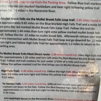


Spent Sunday morning hiking through Neversink River Unique Area. It was a wonderful experience going through this serene and notably untouched wilderness. Don't be scared off by the challenge in finding the park, it is worth it. Quality: Neversink River Unique Area was the highlight of our recent trip to Upstate New York. A surprisingly unspoiled park filled with spectacular features. And while there are main trails, there are also lots of smaller paths to explore, giving creativity to visitors. Mullet Brook Falls may be the biggest attraction, but do not skip the adventure of checking out other areas. Quantity: Neversink River Unique Area is around 6,500 acres with many miles of trails. Value: Free to park and use the trails. Ambiance: Neversink River Unique Area is a lovely recreation area in Upstate New York. It is definitely a lesser known hiking area, which makes it harder to find, but it is worth the extra effort. With multiple waterfalls and rivers, it is a hike with many places you want to stop and enjoy. We did pieces of the blue, yellow, and red trails, which allowed us to visit Denton Falls and Mullet Brook Falls. It is also not an incredibly long or difficult hike, but one that still lets you experience a lot. Crowd: We arrived around 10am on Sunday and were about the eighth car to park. By the time we left three hours later, there was a row of cars along the street around forty long. The trails however are expansive enough that you don't see too many people. Service: Even though it is a less popular hiking area, it is very well-maintained. Easy to follow the trails and minimal garbage left behind. Parking: There is a small parking lot at the trail entrance, but expect to park along the residential street. read more

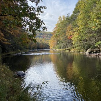

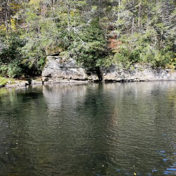


More info about Neversink River Unique Area

















Neversink River Unique Area - hiking - Updated October 2026
Best of Rock Hill
People found Neversink River Unique Area by searching for…
Hiking Trails With Waterfalls in Rock Hill, NY
Walking Trails in Rock Hill, NY
Fishing Spots in Rock Hill, NY
Swimming Lakes in Rock Hill, NY
Scenic Overlook in Rock Hill, NY
River Swimming in Rock Hill, NY
Bait and Tackle Shop in Rock Hill, NY
Fishing Guides in Rock Hill, NY
Waterfalls and Swimming Holes in Rock Hill, NY
Fun Places for Teens in Rock Hill, NY
Private Boat Charters in Rock Hill, NY
Trending Searches in Rock Hill, NY
Apple Orchards near Neversink River Unique Area
Apple Picking near Neversink River Unique Area
Archery near Neversink River Unique Area
Barbershop near Neversink River Unique Area
Baseball Fields near Neversink River Unique Area
Beautiful Views near Neversink River Unique Area
Blow Dry Bar near Neversink River Unique Area
Boating near Neversink River Unique Area
Corn Maze near Neversink River Unique Area
Dog Friendly Things To Do near Neversink River Unique Area
Dog Parks near Neversink River Unique Area
Eyelash Extensions near Neversink River Unique Area
Fishing Tackle Shop near Neversink River Unique Area
Halloween Events near Neversink River Unique Area
Haunted Houses near Neversink River Unique Area
Hiking Trails near Neversink River Unique Area
Kids Birthday Party near Neversink River Unique Area
Lakes near Neversink River Unique Area
Makeup Artists near Neversink River Unique Area
Off Road Trails near Neversink River Unique Area
Photo Spots near Neversink River Unique Area
Picnic Spots near Neversink River Unique Area
Places To Take Pictures near Neversink River Unique Area
Playgrounds near Neversink River Unique Area
Private Schools near Neversink River Unique Area
Public Running Track near Neversink River Unique Area
Public Shower near Neversink River Unique Area
Public Tennis Courts near Neversink River Unique Area
Pumpkin Patches near Neversink River Unique Area
Scenic Overlook near Neversink River Unique Area
Swimming Holes near Neversink River Unique Area
Browse Nearby
Browse Brands
Related Searches in Rock Hill, NY
Affordable Fishing Rental Services in Rock Hill, New York
Affordable Kayak Rental Services in Rock Hill, New York
Best Boat Launch Spots in Rock Hill, New York
Best Dog Hiking Trails Around Rock Hill, New York
Best Fishing Locations and Guides in Rock Hill, New York
Best Parks for Parties and Events in Rock Hill, New York
Best Places for Horseback Riding in Rock Hill, New York
Best Pontoon Boat Rentals Near Rock Hill, New York
Best Sledding Spots and Fun in Rock Hill, New York
Best Water Parks for Kids in Rock Hill, New York
Best Waterfalls and Swimming Holes in Rock Hill, New York
Book Top Fishing Trips in Rock Hill, New York Today
Book a Dinner Cruise Experience in Rock Hill, New York
Check Out Great Playgrounds in Rock Hill, New York
Check Out Off Road Trails in Rock Hill, New York
Discover Baseball Fields Around Rock Hill, New York
Discover Dog Friendly Trails to Explore in Rock Hill, New York
Discover Fun Toddler Parks in Rock Hill, New York for Your Little One
Discover Lakes & Ponds to Explore in Rock Hill, New York
Discover Popular Bike Trails in Rock Hill, New York
Discover Popular Photo Spots in Rock Hill, New York
Discover Scenic Mountain Bike Trails Near Rock Hill, New York
Discover Soccer Fields in Rock Hill, New York Near You
Discover Top Boat Tours in Rock Hill, New York for All Ages
Discover Top Nature Parks to Visit in Rock Hill, New York
Discover a Hiking Trail in Rock Hill, New York
Discover the Best Beaches in Rock Hill, New York
Discover the Best Fishing Lake in Rock Hill, New York
Discover the Best Night Hike Trails in Rock Hill, New York
Dog-Friendly Hikes With Dogs in Rock Hill, New York
Enjoy Camping Adventures Around Rock Hill, New York
Enjoy Exciting Mountain Biking Adventures in Rock Hill, New York
Enjoy Fishing Pier Spots in Rock Hill, New York With Scenic Views
Enjoy Fishing With Kids in Rock Hill, New York Safely
Enjoy Hiking Adventures in Rock Hill, New York
Enjoy Jet Ski Adventures in Rock Hill, New York
Enjoy Off Leash Dog Hikes in Rock Hill, New York
Enjoy the Best Walking Trails in Rock Hill, New York
Experience Amazing Scuba Diving in Rock Hill, New York
Experience Deep Sea Fishing Adventures in Rock Hill, New York
Experience Thrilling White Water Rafting in Rock Hill, New York
Experienced Fishing Guides Available in Rock Hill, New York
Explore Beautiful Parks and Green Spaces in Rock Hill, New York
Explore Easy Hikes Perfect for All in Rock Hill, New York
Explore Family-Friendly Zoos and Wildlife in Rock Hill, New York
Explore Free Picnic Areas Around Rock Hill, New York
Explore Fun Activities to Do in Rock Hill, New York
Explore Outdoor Basketball Courts for All Skill Levels in Rock Hill, New York


