1. Mule Canyon Cave Towers

0

,

Cancel

Open app

Search

Mule Canyon Cave Towers

5.0 (1 review)

Mule Canyon Cave Towers Photos

More like Mule Canyon Cave Towers

Recommended Reviews - Mule Canyon Cave Towers

Your trust is our priority, so businesses can't pay to alter or remove their reviews. Learn more about reviews.
Yelp app icon
Browse more easily on the app
Review Feed Illustration

11 months ago

Helpful 1
Thanks 0
Love this 1
Oh no 0

Verify this business for free

Get access to customer & competitor insights.

Verify this business

Butler Wash Ruins - Butler wash ruins

Butler Wash Ruins

4.0(3 reviews)
80.7 km

This whole area is kind of confusing as the entrances are small and not well marked. I stopped by…read moremultiple visitor centers to see how I could get to the dinosaur track site, and the map I was provided took me down a bumpy dirt road that took a long time to navigate as I was in a sedan - and then when I let the site I found that there's another entrance off the highway that is much more direct and right off the highway. Anyways, it took a while to find the tracks as they're pretty eroded and not protected at all. There are multiple signs saying to not park on the tracks as it's right off the road and I could see that people might park on it mistakenly thinking it was a parking area. I would not recommend visiting the tracksite since it's pretty underwhelming. Visiting the Butler Wash Ruins was a much better experience, although you have to keep an eye out for the entrance off the highway as it's not well marked. It takes you to a parking lot and the trail goes from dirt/gravel to a slickrock area that is well marked with cairns.

Blanding is a great base from which to explore the area. Not too far away, going southwest on…read moreHighway 95 toward Natural Bridges Monument, are the Butler Wash Ruins dating from about AD 1200. From the parking area, it's a short walk to the overlook from which you can see the cliff dwellings on the other side of a narrow canyon. While you can't get close to the dwellings (unless you're a bit of gecko), you can explore the slick rock area and find a small arch on the other side of the dwellings. (It's not visible from the overlook area.) I've been here a few times and have spent a few hours each time exploring the area. However, most visitors will probably take a few snapshots and be on their way.

Photos
Butler Wash Ruins - The tracks - Very slight depressions due to erosion

The tracks - Very slight depressions due to erosion

Butler Wash Ruins - Informational sign

Informational sign

Butler Wash Ruins - Informational sign

See all

Informational sign

Looking Glass Arch

Looking Glass Arch

4.3(3 reviews)
74.3 km

The climb is located eastern rib ( 38°16'30.37"N 109°24'11.85"W). Extremely fun, and easy climb…read more Just as stated, 3 pitches to the summit, and accurate information. All solid bolts with the exception of the second bolt on the second pitch are slightly loose but unfortunately didn't have the equipment to fix. Just bolts on third pitch anchors, no chains or rings. A 60m rope runout on a double rap on the third pitch, but it's walkable to pitch 2 anchors --make sure you close the system. Climbed on 06-22-2018. Didn't see any rattlers on this climb --though their holes are everywhere.

We decided to check out Looking Glass Arch for a quickie climb before we headed back to CO. I had…read moreread about an easy 3-pitch bolted route (Regular Route) that tops out on the summit followed by an ~115 ft free hanging rappel. We were a bit thrashed from climbing Honeymoon Chimney the day prior in nasty winds and my climbing partner was sick, so this seemed like the perfect objective. The amphitheater/arch are quite spectacular and it's worth the short hike even if you don't want to climb. We were there on a Sunday and it wasn't a zoo like some areas in Arches. The arch is ~5 min from the parking lot. No water/bathrooms so plan ahead. DIRECTIONS The easiest way to get to the arch is to turn right on Looking Glass Road (23 miles from central Moab on Hwy 191 south). If you hit Wilson Arch you've gone too far. Once on Looking Glass Road the side road to Looking Glass Rock is signed. The road is passable with 2WD or low clearance vehicles.

Photos
Looking Glass Arch
Looking Glass Arch
Looking Glass Arch

See all

Dead Horse Point State Park

Dead Horse Point State Park

4.7(147 reviews)
100.4 km

I had most incredible experience solo camping and canoeing out here. The peacefulness, the awe of…read morebeauty, the sheer magnitude of it all, it's really something quite special. Photos and videos do not do it justice. You have to experience it for yourself, seriously! Every new bend around the corner was even more breathtaking than the last. If you get a chance, definitely paddle the river. It's a whole new perspective down there!!

Dead Horse Point State Park is absolutely stunning--and pet friendly! The overlooks alone are worth…read morethe stop, but there are also several trails to choose from. We hiked the East Rim Trail, which connects to the West Rim Trail, for a total of about 3.9 miles. I'd rate it as easy to moderate: mostly flat with a few sections of light climbing. The views throughout the hike are breathtaking, and when we went, it wasn't crowded at all. Keep in mind that the park is very hot with almost no shade, so bring plenty of water. If you're traveling with a dog, be mindful of the ground temperature to avoid burning their paw pads. The visitor center itself isn't pet-friendly, but the bathrooms are located outside and accessible. My only complaint is that the trail markers could be clearer--since some trails overlap, it can get confusing. Entry is $20 per vehicle, paid at the gate. We spent about 2.5 hours exploring, though you could easily stay longer if you want to sit, relax, and take in the scenery. Overall, this is a must-visit stop in Moab.

Photos
Dead Horse Point State Park
Dead Horse Point State Park - Dead Horse Point State Park Utah

Dead Horse Point State Park Utah

Dead Horse Point State Park

See all

Goblin Valley State Park

Goblin Valley State Park

4.8(72 reviews)
151.1 km

Giving 5 stars even just for the view coming out here. It is SO gorgeous! There is a really nice…read morevisitor center just before you enter the park as well where you can get recs from staff or pick up a map or some other souvenirs). I didn't do the drive into the rest of the park because it's a $20 entry fee and I only had like 20 mins at the time to explore so I didn't think it would be worth it to pay and just drive further in/out for 20 min. But again, even just the view there is absolutely beautiful, the vistas are stunning - like an extension of both Capitol reef and Canyonlands. It's very remote though, so make sure if you really want to explore you have at least a few hours to do some of the longer trails. The little hoodoos are very cute and there are many ways to view them here so if you want to explore these more, this is definitely a fantastic spot (along with Bryce Canyon of course, and some of the small other random hikes through Arizona and Utah eg the Toadstools hike right at their border).

We took this as a side trip and we really should have given this more time. If you are thinking of…read morecoming here, I recommend looking at all the activities offered to see how much is here to do so you won't feel as though you missed out on some of what makes this park FUN! As for us, we ran around the valley, played hide and seek, marveled at how these "goblins" were made and just had a great adventure with the time we had.
Photos
Goblin Valley State Park
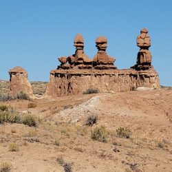
Goblin Valley State Park - Close up of the Three Sisters.

Close up of the Three Sisters.

Goblin Valley State Park - The start of Valley 1. Valley of the Goblins basin has 3 total sections for you to explore however you want.

See all

The start of Valley 1. Valley of the Goblins basin has 3 total sections for you to explore however you want.

Mule Canyon Cave Towers - hiking - Updated October 2026

Loading...
Loading...
Loading...