Kingston Point Beach Photos


More like Kingston Point Beach
Recommended Reviews - Kingston Point Beach
Start your review...

Reviews With Photos

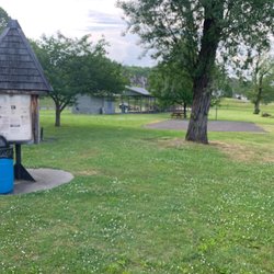
A very scruffy beach Kingston Point Beach is located toward the end of a dead end road across the street from a old park. The actual beach is pretty small but does have a playground, small boat launch, picnic area and little building they call an interpretive center.. I've never actually been here during the summer, just in the off season when nobody is there. Perhaps that is why the beach looks so messy with lots of debris and stuff washed up on the shore and with a very unbeachy feel. I'm not sure how clean this water is and although the water itself didn't really look nasty the area has abandoned old factories, buildings and agricultural land close by so I suspect this might be water better suited for looking than swimming. The views are pretty impressive in a scruffy sort of way. A huge bridge is visible in the distance and a rusty remains of a huge factory or warehouse are visible. Everything about the beach looks kinds of worn and old and certainly is different than the typical beaches I have been on. A unique beach in an unusual location with curious things to look at. Definitely an interesting contrast to the long, clean and sandy beaches of Cape Cod and Rhode island.

3 years ago


6 years ago
The view is very beautiful. I love the fresh fish smell. And is is the best place to go to during the spring or summer. It will be closer if you live in Kingston. You may also have a BBQ orOtherkinds of parties, just no loud music. read more


7 years ago
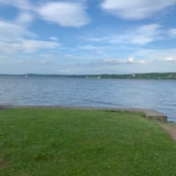
It's been several years since I was on Kingston Point Beach, and up until today, I had never had that one moment of "peace, quiet and tranquility" you get when you visit a beach - alone. However, was coming back from dropping a Shipt order (from Target) nearby so thought I'd stop in when I ran across this beach. I had known about this beach for quite some time, but kept forgetting about it's whereabouts, until I discovered it's one and only route when finding it with Uber. However, when I got to this beach, I knew I was unprepared to go in, but I went in anyways. I didn't have a towel to dust myself off, but knew I had to - due to my calloused feet. I went into the water - just as far as a few inches - so the waves and water could reach and go around my ankles. However, was totally flustered at all the tree branch pieces on the dry sand which made the walk quite an interesting one which kept stabbing my feet as I came to walk in and out of the beachfront. I mean, I had sandals, but I wasn't thinking about towels...nor did I see a water-cleansing spout, so I don't think anyone here really has mentioned that people do need these smaller services. I loved the scenery. The Kingston-Rhinecliff Bridge in the distance, and even the fact that speedboats tend to help bring in waves occasionally. If it wouldn't be for the 18 minute jaunt and the fact that there's a toll bridge in the way between my Dutchess Co home and this beach, I'd be here more often - and today it was almost a necessity at 90 degrees plus Fahrenheit. I saw a few beachgoers sunbathing on towels and several in the water with only a few lifeguards. I also saw some volleyball courts, but no one was playing there. Just wish that you wouldn't have to cross past these during a game to get to the beach. Not cool - thank heavens no games were going on when I went past. Parking was excellent. Despite not having the best spots for handicapped, there are several really great spots at the wall near the entrance locations- but that road getting to the park can be a bit rough, and because it's so far out of tune of everything else, can be a little bummer to feel safe and secure at these beaches and parks. There's little in the way of beachfront parks to send kids to here. However, it's quite a walk to the nearest kids and dog parks across Delaware Ave. I know I made the right choice today, just wish I would have come more prepared. read more

13 years ago
A very scruffy beach Kingston Point Beach is located toward the end of a dead end road across the street from a old park. The actual beach is pretty small but does have a playground, small boat launch, picnic area and little building they call an interpretive center.. I've never actually been here during the summer, just in the off season when nobody is there. Perhaps that is why the beach looks so messy with lots of debris and stuff washed up on the shore and with a very unbeachy feel. I'm not sure how clean this water is and although the water itself didn't really look nasty the area has abandoned old factories, buildings and agricultural land close by so I suspect this might be water better suited for looking than swimming. The views are pretty impressive in a scruffy sort of way. A huge bridge is visible in the distance and a rusty remains of a huge factory or warehouse are visible. Everything about the beach looks kinds of worn and old and certainly is different than the typical beaches I have been on. A unique beach in an unusual location with curious things to look at. Definitely an interesting contrast to the long, clean and sandy beaches of Cape Cod and Rhode island. read more


6 years ago
Nice small family oriented beach wasn't crowded at all ! Came here For the first tile August 19th with my family and they had a blast it was my daughters first time feeling sand and she loved it ! Will come back again read more

5 years ago
10 years ago
More info about Kingston Point Beach
53 Delaware Ave
Kingston, NY 12401
Directions
(845) 338-0670
Call Now
Hours
Outdoor Amenities
Ask the Community - Kingston Point Beach


Why does Yelp recommend reviews?
3 reviews that are not currently recommended
The reviews below are not factored into the business's overall star rating.
4 years ago
7 months ago
2 months ago
Kingston Point Beach - beaches - Updated June 2026
Best of Kingston
People found Kingston Point Beach by searching for…
Things to Do in Kingston, New York
Playgrounds in Kingston, New York
Scenic View in Kingston, New York
Fishing Spots in Kingston, New York
Places to Swim in Kingston, New York
Volleyball Courts in Kingston, New York
Picnic Areas in Kingston, New York
Swimming Lakes in Kingston, New York
Swimming in Kingston, New York
Boat Launch in Kingston, New York
Places to Take Pictures in Kingston, New York
Swimming Holes in Kingston, New York
Playgrounds for Kids in Kingston, New York
Scenic Overlook in Kingston, New York
View Points in Kingston, New York
Sunbathing in Kingston, New York
Beautiful Views in Kingston, New York
Scenic Drive in Kingston, New York
Beach Volleyball in Kingston, New York
Fun Things to Do With Kids in Kingston, New York
Picnic Areas BBQ Pits in Kingston, New York
Trending Searches in Kingston, NY
4th Of July Fireworks near Kingston Point Beach
Black Owned Nail Salons near Kingston Point Beach
Boat Rental near Kingston Point Beach
Caves near Kingston Point Beach
Cliff Jumping near Kingston Point Beach
Crabbing Location near Kingston Point Beach
Day Trips near Kingston Point Beach
Dog Friendly Beaches near Kingston Point Beach
Fireworks near Kingston Point Beach
Fishing Spots near Kingston Point Beach
Jet Ski Rental near Kingston Point Beach
Kayak Rental near Kingston Point Beach
Public Beaches near Kingston Point Beach
Public Pools near Kingston Point Beach
River Swimming near Kingston Point Beach
Salt Water Pool near Kingston Point Beach
Snorkeling near Kingston Point Beach
Splash Pad near Kingston Point Beach
Strawberry Picking near Kingston Point Beach
Sunrise View near Kingston Point Beach
Swimming Holes near Kingston Point Beach
Swimming Lakes near Kingston Point Beach
Volleyball Courts near Kingston Point Beach
Browse Articles
Browse Nearby
BEST of Kingston, New York Restaurants near Kingston Point Beach
BEST of Kingston, New York Coffee near Kingston Point Beach
BEST of Kingston, New York Things to Do near Kingston Point Beach
BEST of Kingston, New York Lakes near Kingston Point Beach
BEST of Kingston, New York Breakfast near Kingston Point Beach
BEST of Kingston, New York Watch Sunset near Kingston Point Beach
BEST of Kingston, New York Resorts near Kingston Point Beach
BEST of Kingston, New York Hotels near Kingston Point Beach
BEST of Kingston, New York Campgrounds near Kingston Point Beach
Browse Brands
Related Searches in Kingston, NY
Affordable Kayak Rental Services in Kingston, New York
Affordable Paddle Board Rental in Kingston, New York
Best Boat Launch Spots in Kingston, New York
Best Waterfalls and Swimming Holes in Kingston, New York
Browse Top Hotels in Kingston, New York for Your Stay
Browse Vacation Rentals to Book in Kingston, New York
Discover Dog Friendly Beaches Near Kingston, New York
Discover Lakes & Ponds to Explore in Kingston, New York
Discover Public Beaches to Visit in Kingston, New York
Discover Public Pools Open in Kingston, New York
Discover Scenic Beach Camping Sites in Kingston, New York
Discover Top Boat Tours in Kingston, New York for All Ages
Enjoy Surfing Adventures in Kingston, New York
Enjoy Water Activities and Fun in Kingston, New York
Enjoy the Best Walking Trails in Kingston, New York
Exciting Water Sports Activities to Try in Kingston, New York
Experience Stunning Sunset Views in Kingston, New York
Explore Beautiful Parks and Green Spaces in Kingston, New York
Explore Off Leash Dog Beaches in Kingston, New York
Explore Popular Campgrounds Near Kingston, New York
Explore Popular RV Parks Around Kingston, New York
Explore Scenic Lakes to Visit in Kingston, New York
Explore Secret Spots Worth Visiting in Kingston, New York
Explore Top Dog Parks in Kingston, New York Near You
Explore Top Marinas Near Kingston, New York
Explore Top Water Parks in Kingston, New York Today
Explore the Best Boating Spots in Kingston, New York
Explore the Best Swimming Holes Around Kingston, New York
Find Beautiful Views in Kingston, New York
Find Top Skate Parks in Kingston, New York for All Skill Levels
Find the Best Parks for Picnics in Kingston, New York
Find the Best Playgrounds to Visit in Kingston, New York
Find the Best Swimming Pools in Kingston, New York Today
Great Places to Swim in Kingston, New York
Hiking Trails With Waterfalls in Kingston, New York
Must-See Tourist Attractions Around Kingston, New York
Perfect Spots to Watch Sunset in Kingston, New York
Popular Fishing Spots to Explore in Kingston, New York
Popular Outdoor Activities to Try in Kingston, New York
Popular Picnic Spots to Visit in Kingston, New York
Popular Places to Take Pictures in Kingston, New York
Safe River Swimming Areas in Kingston, New York
Safe and Fun Parks for Kids in Kingston, New York
Top Hiking Trails to Explore in Kingston, New York
Top Paddleboarding Activities in Kingston, New York
Top Places for Snorkeling in Kingston, New York
Top Playgrounds for Kids to Enjoy in Kingston, New York
Top Swimming Lakes to Enjoy in Kingston, New York
People who viewed Kingston Point Beach also viewed
Belleayre Beach
9 reviews
Walkway Over the Hudson State Historic Park
359 reviews
Charles Rider Park
4 reviews
Victor C Waryas Park
8 reviews
Quiet Cove Riverfront Park
6 reviews
Minnewaska State Park Preserve
169 reviews
Robert Post Park
5 reviews
Upper Landing Park
4 reviews
Freedom Park
1 review
Wilcox Memorial Park
3 reviews