Kennebec River Rail Trail Photos


You might also consider
More like Kennebec River Rail Trail
Recommended Reviews - Kennebec River Rail Trail
Start your review...

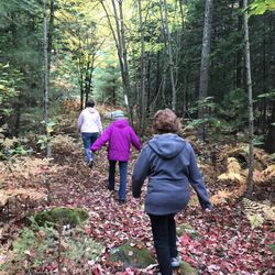
6 months ago
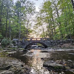
This trail was really close to where we were in Augusta so we walked it instead of driving to a state park 35 minutes away. The path was paved and easily walkable. The foliage was okay. Supposedly there was a drought this summer causing the foliage to be less brilliant this year. Either way, coming up to visit family from Florida, I was thrilled to see the change of seasons. I suggest taking photos of the bridge and make sure you take water on the trail. I didn't see restrooms. There were port a potty's in the parking lot where we started. read more


More info about Kennebec River Rail Trail
Augusta, ME 04330
Directions
Hours
Outdoor Amenities


Kennebec River Rail Trail - hiking - Updated May 2026
Best of Augusta
People found Kennebec River Rail Trail by searching for…
Trending Searches in Augusta, ME
Botanical Gardens near Kennebec River Rail Trail
Bounce House Rentals near Kennebec River Rail Trail
Campgrounds near Kennebec River Rail Trail
Dog Friendly Trails near Kennebec River Rail Trail
Floral Designers near Kennebec River Rail Trail
Garage Sales near Kennebec River Rail Trail
Garden Center near Kennebec River Rail Trail
Golf Lessons near Kennebec River Rail Trail
Lakes & Ponds near Kennebec River Rail Trail
Mens Suits near Kennebec River Rail Trail
Nurseries & Gardening near Kennebec River Rail Trail
Outdoor Furniture Stores near Kennebec River Rail Trail
Parks near Kennebec River Rail Trail
Party Equipment Rentals near Kennebec River Rail Trail
Pedicure near Kennebec River Rail Trail
Photo Spots near Kennebec River Rail Trail
Picnic Areas near Kennebec River Rail Trail
Running Trails near Kennebec River Rail Trail
Spray Tanning near Kennebec River Rail Trail
Browse Articles
Browse Nearby
BEST of Augusta, Maine Coffee near Kennebec River Rail Trail
BEST of Augusta, Maine Restaurants near Kennebec River Rail Trail
BEST of Augusta, Maine Things to Do near Kennebec River Rail Trail
BEST of Augusta, Maine Parks near Kennebec River Rail Trail
BEST of Augusta, Maine Breakfast near Kennebec River Rail Trail
BEST of Augusta, Maine Hotels near Kennebec River Rail Trail
BEST of Augusta, Maine Photo Spots near Kennebec River Rail Trail
BEST of Augusta, Maine Campgrounds near Kennebec River Rail Trail
Browse Brands
Related Searches in Augusta, ME
Affordable Kayak Rental Services in Augusta, Maine
Best Fishing Locations and Guides in Augusta, Maine
Best Fun Things to Do in Augusta, Maine
Best Lookout Points to Visit in Augusta, Maine
Best Places for Horseback Riding in Augusta, Maine
Best Sledding Spots and Fun in Augusta, Maine
Discover Dog Friendly Beaches Near Augusta, Maine
Discover Dog Friendly Trails to Explore in Augusta, Maine
Discover Lakes & Ponds to Explore in Augusta, Maine
Discover Popular Photo Spots in Augusta, Maine
Discover a Hiking Trail in Augusta, Maine
Discover the Best Night Hike Trails in Augusta, Maine
Discover the Best Running Track in Augusta, Maine
Dog-Friendly Hikes With Dogs in Augusta, Maine
Enjoy Exciting Mountain Biking Adventures in Augusta, Maine
Enjoy the Best Family Activities in Augusta, Maine
Enjoy the Best Tubing Experiences in Augusta, Maine
Experience Stunning Sunset Views in Augusta, Maine
Explore Beautiful Parks and Green Spaces in Augusta, Maine
Explore Bike Rentals Throughout Augusta, Maine
Explore Easy Hikes Perfect for All in Augusta, Maine
Explore Free Things to Do Around Augusta, Maine
Explore Popular Campgrounds Near Augusta, Maine
Explore Popular Scenic Overlook Points in Augusta, Maine
Explore Scenic Lakes to Visit in Augusta, Maine
Explore Secret Spots Worth Visiting in Augusta, Maine
Explore Top Dog Parks in Augusta, Maine Near You
Explore the Best Boating Spots in Augusta, Maine
Explore the Best Swimming Holes Around Augusta, Maine
Family Friendly Hiking With Kids in Augusta, Maine
Find Beautiful Views in Augusta, Maine
Find Fun Things to Do With Kids in Augusta, Maine
Find Top-Rated Disc Golf in Augusta, Maine
Find the Best Playgrounds to Visit in Augusta, Maine
Fun Toddler Activities to Try in Augusta, Maine
Hiking Trails With Waterfalls in Augusta, Maine
Off Leash Dog Hiking Trails in Augusta, Maine
Perfect Spots to Watch Sunset in Augusta, Maine
Popular Kids Activities in Augusta, Maine
Popular Picnic Spots to Visit in Augusta, Maine
Popular Places to Take Pictures in Augusta, Maine
Popular Things to Do in Augusta, Maine
Top Climbing Spots and Gyms in Augusta, Maine
Top Paddleboarding Activities in Augusta, Maine
Top Playgrounds for Kids to Enjoy in Augusta, Maine
Top Running Trails to Explore in Augusta, Maine
Top Swimming Lakes to Enjoy in Augusta, Maine
Top Things to Do With Kids in Augusta, Maine
People who viewed Kennebec River Rail Trail also viewed
Talking Brook Public Land
1 review
Annie Sturgis Sanctuary
1 review
Riverbend Campground
1 review
Ulin Point And Lupine Field
1 review
Purinton Homestead Conservation Trail
1 review
Robin's Garden & Dog Park
3 reviews
Maine Outdoors
1 review
Reynolds Forrest
1 review
Papermill Trail
2 reviews
Litchfield Fair Ground
1 review