Iron Ore Heritage Trail Mountain Biking Photos


! - Mountain Biking Near Me - Marquette, Michigan")
More like Iron Ore Heritage Trail
Recommended Reviews - Iron Ore Heritage Trail
Start your review...

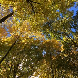
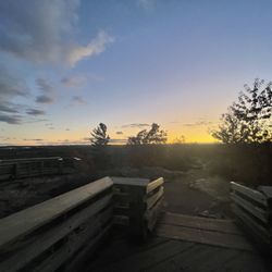
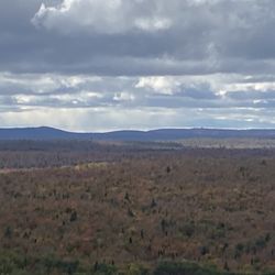
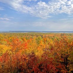
After moving here from the bike-friendliest spot in America (often tied for first with Portland, yes I know), I was yearning for a great trail to just ride; no cars, consistent surface and lots of scenery. The Iron Ore Heritage Trail (IOHT) does not disappoint. With equal parts of nature and history, it's a great destination for walkers, riders, joggers, kids and families. While not completely paved, the crushed aggregate is easily navigated on my city bike. I went out yesterday after a night of rain and the path was in great shape (surprise!). Folks in the area are very proud of this trail and rightfully so. It's beautiful and fun, a treasure for all ages to enjoy. read more


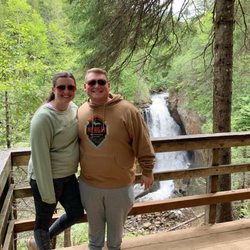
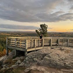
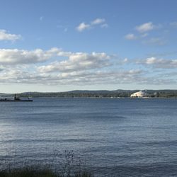
The Iron Ore Heritage Trail is a 47 Mile long multi-use trail that runs along Lake Superior and deep into the forests throughout Marquette County in Upper Michigan. The trails (which are basically the old railways that were used to move ore to the kilns along the lake) are now used for recreation such as hiking and biking. Along Lake Superior it passes through many parks and beaches with amazing views. There are also places to eat, shop or have a drink along the trail (at least in Marquette). I have only been on the trails in Marquette, which is a small portion of the 47 miles, but according to the information available online or at most touristy spots, there are plenty on other sights, foods and history to take in along the rest of the trail. All free! read more


3 years ago
5 years ago
More info about Iron Ore Heritage Trail


Iron Ore Heritage Trail - mountainbiking - Updated May 2026
Best of Marquette
People found Iron Ore Heritage Trail by searching for…
Hiking Trails in Marquette, MI
Beautiful Views in Marquette, MI
Fun Things to Do at Night in Marquette, MI
Natural Hot Springs in Marquette, MI
Swimming Lakes in Marquette, MI
Walking Trails in Marquette, MI
Off Road Trails in Marquette, MI
Running Trails in Marquette, MI
Electric Bikes in Marquette, MI
Tourist Attractions in Marquette, MI
Trending Searches in Marquette, MI
Beautiful Views near Iron Ore Heritage Trail
Boat Rental near Iron Ore Heritage Trail
Campgrounds near Iron Ore Heritage Trail
Flower Shop near Iron Ore Heritage Trail
Garage Sales near Iron Ore Heritage Trail
Garden Center near Iron Ore Heritage Trail
Hair near Iron Ore Heritage Trail
Hiking near Iron Ore Heritage Trail
Nurseries & Gardening near Iron Ore Heritage Trail
Outdoor Furniture Stores near Iron Ore Heritage Trail
Parks near Iron Ore Heritage Trail
Party Equipment Rentals near Iron Ore Heritage Trail
Pedicure near Iron Ore Heritage Trail
Picnic Areas near Iron Ore Heritage Trail
Places To Take Pictures near Iron Ore Heritage Trail
Secret Spots near Iron Ore Heritage Trail
Sunrise View near Iron Ore Heritage Trail
Browse Articles
Browse Nearby
BEST of Marquette, Michigan Restaurants near Iron Ore Heritage Trail
BEST of Marquette, Michigan Coffee near Iron Ore Heritage Trail
BEST of Marquette, Michigan Things to Do near Iron Ore Heritage Trail
BEST of Marquette, Michigan Breakfast near Iron Ore Heritage Trail
BEST of Marquette, Michigan Shopping near Iron Ore Heritage Trail
BEST of Marquette, Michigan Campgrounds near Iron Ore Heritage Trail
BEST of Marquette, Michigan Thrift Stores near Iron Ore Heritage Trail
BEST of Marquette, Michigan Hotels near Iron Ore Heritage Trail
Browse Brands
Related Searches in Marquette, MI
Affordable Bike Repair Services in Marquette, Michigan
Affordable Kayak Rental Services in Marquette, Michigan
Best Fishing Locations and Guides in Marquette, Michigan
Best Fun Things to Do in Marquette, Michigan
Best Lookout Points to Visit in Marquette, Michigan
Best Nature Trails for Hiking in Marquette, Michigan
Best Places for Stunning Views in Marquette, Michigan
Best Sledding Spots and Fun in Marquette, Michigan
Best Waterfalls and Swimming Holes in Marquette, Michigan
Check Out Off Road Trails in Marquette, Michigan
Discover Dog Friendly Trails to Explore in Marquette, Michigan
Discover Popular Bike Trails in Marquette, Michigan
Discover Popular Photo Spots in Marquette, Michigan
Discover Scenic Waterfall Spots in Marquette, Michigan
Discover Top Nature Parks to Visit in Marquette, Michigan
Discover a Hiking Trail in Marquette, Michigan
Discover the Best Night Hike Trails in Marquette, Michigan
Dog-Friendly Hikes With Dogs in Marquette, Michigan
Enjoy Exciting Mountain Biking Adventures in Marquette, Michigan
Enjoy Hiking Adventures in Marquette, Michigan
Enjoy Kayaking Adventures in Marquette, Michigan
Enjoy Tent Camping Spots Around Marquette, Michigan
Enjoy Water Activities and Fun in Marquette, Michigan
Enjoy the Best Tubing Experiences in Marquette, Michigan
Enjoy the Best Walking Trails in Marquette, Michigan
Explore Beautiful Parks and Green Spaces in Marquette, Michigan
Explore Bike Rentals Throughout Marquette, Michigan
Explore Easy Hikes Perfect for All in Marquette, Michigan
Explore Electric Bikes Available in Marquette, Michigan
Explore Fun Activities to Do in Marquette, Michigan
Explore Popular Boat Charters Near Marquette, Michigan
Explore Popular Campgrounds Near Marquette, Michigan
Explore Popular RV Parks Around Marquette, Michigan
Explore Popular Scenic Overlook Points in Marquette, Michigan
Explore Popular View Points Around Marquette, Michigan
Explore Scenic Lakes to Visit in Marquette, Michigan
Explore Top Water Parks in Marquette, Michigan Today
Explore the Best Beach Spots in Marquette, Michigan
Explore the Best Boating Spots in Marquette, Michigan
Explore the Best Trail Options in Marquette, Michigan
Explore the Scenic River in Marquette, Michigan
Family Friendly Hiking With Kids in Marquette, Michigan
Find Beautiful Views in Marquette, Michigan
Find Fun Kids Activities Outdoor in Marquette, Michigan
Find Specialized Bikes and Accessories in Marquette, Michigan
Find Top-Rated Waterfalls in Marquette, Michigan Now
Find the Best Bikes Available in Marquette, Michigan
Find the Best Parks for Picnics in Marquette, Michigan