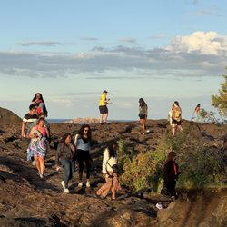
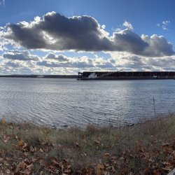
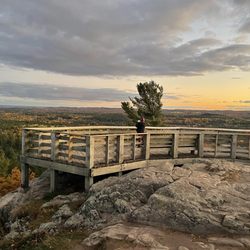
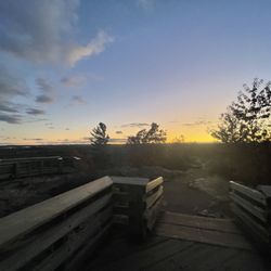
Hogback Mountain Photos


You might also consider
More like Hogback Mountain
Recommended Reviews - Hogback Mountain
Start your review...

3 months ago


2 years ago
BRING GOOD SHOES. I've only hiked it in winter. It's a fun and STEEP hike! To me, not beginner friendly. In winter, you need to be careful on the top because she gets SLIPPERY. Climbing up can be dangerous depending on the snow. Definitely encourage a group hike than a single. 2 people is probably fine Going downhill in winter should be a universal experience for the upper peninsula community. Bring a sled if you can. I had immense fun and love talking about it. Do NOT hike while it is snowing or very windy. It's definitely possible to get lost (applies to any hike tbh) it's a great workout though! I WOULD hike again read more
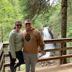
I hiked a mountain! It's no out west mountain, but it's referred to as a mountain, so I'm sticking with that. We went with friend last fall who were familiar and had hiked it before, which was lucky because the trail was a little confusing at points and apparently there is more than one way up, with one being more difficult. Not quite sure on that, but I'm glad we did the less difficult route, if that's true. It was challenging enough but not so hard that I felt like dying. The first part of the trail from the parking lot is pretty flat through the woods. Once you get up further up and closer to the top, there are a couple spots where you may have to use your hands to climb over some rocks (but not full on rock climbing). I recommend wearing good shoes with grip. Also, watch for slippery mossy rocks while hiking. The trail is pretty well groomed. The elevation gain isn't too bad but I was definitely breathing hard at points. The view at the top makes it worth it! I don't think I'd need to hike this every time I'm in the area, but I'm so glad we did it at least once. read more


More info about Hogback Mountain
Marquette, MI 49855
Directions
Hours
Outdoor Amenities


Hogback Mountain - hiking - Updated July 2026
Best of Marquette
People found Hogback Mountain by searching for…
Things to Do in Marquette, Michigan
Hiking Trails in Marquette, Michigan
Waterfalls in Marquette, Michigan
View Points in Marquette, Michigan
Walking Trails in Marquette, Michigan
Beautiful Views in Marquette, Michigan
Rock Climbing in Marquette, Michigan
Easy Hikes in Marquette, Michigan
Stuff to Do in Marquette, Michigan
Hikes With Waterfalls in Marquette, Michigan
Running Trails in Marquette, Michigan
Public Shower in Marquette, Michigan
Fun Things to Do on Your Birthday in Marquette, Michigan
Scenic Views in Marquette, Michigan
Things to Do on a Rainy Day in Marquette, Michigan
River Swimming in Marquette, Michigan
Scenic Drive in Marquette, Michigan
Camping in Marquette, Michigan
Trending Searches in Marquette, MI
Boat Rental near Hogback Mountain
Fishing Spots near Hogback Mountain
Kayak Rental near Hogback Mountain
Off Road Trails near Hogback Mountain
Public Shower near Hogback Mountain
Sunrise View near Hogback Mountain
Swimming Holes near Hogback Mountain
Swimming Lakes near Hogback Mountain
Browse Articles
Browse Nearby
BEST of Marquette, Michigan Parks near Hogback Mountain
BEST of Marquette, Michigan Restaurants near Hogback Mountain
BEST of Marquette, Michigan Things to Do near Hogback Mountain
BEST of Marquette, Michigan Coffee near Hogback Mountain
BEST of Marquette, Michigan Breakfast near Hogback Mountain
BEST of Marquette, Michigan Museums near Hogback Mountain
BEST of Marquette, Michigan Sledding near Hogback Mountain
BEST of Marquette, Michigan Campgrounds near Hogback Mountain
Browse Brands
Related Searches in Marquette, MI
Affordable Kayak Rental Services in Marquette, Michigan
Best Fishing Locations and Guides in Marquette, Michigan
Best Fun Things to Do in Marquette, Michigan
Best Nature Trails for Hiking in Marquette, Michigan
Best Sledding Spots and Fun in Marquette, Michigan
Best Waterfalls and Swimming Holes in Marquette, Michigan
Check Out Off Road Trails in Marquette, Michigan
Discover Dog Friendly Trails to Explore in Marquette, Michigan
Discover Popular Bike Trails in Marquette, Michigan
Discover Popular Photo Spots in Marquette, Michigan
Discover Scenic Waterfall Spots in Marquette, Michigan
Discover a Hiking Trail in Marquette, Michigan
Discover the Best Night Hike Trails in Marquette, Michigan
Dog-Friendly Hikes With Dogs in Marquette, Michigan
Enjoy Exciting Mountain Biking Adventures in Marquette, Michigan
Enjoy Kayaking Adventures in Marquette, Michigan
Enjoy Tent Camping Spots Around Marquette, Michigan
Enjoy Water Activities and Fun in Marquette, Michigan
Enjoy the Best Tubing Experiences in Marquette, Michigan
Enjoy the Best Walking Trails in Marquette, Michigan
Explore Beautiful Parks and Green Spaces in Marquette, Michigan
Explore Bike Rentals Throughout Marquette, Michigan
Explore Easy Hikes Perfect for All in Marquette, Michigan
Explore Fun Activities to Do in Marquette, Michigan
Explore Popular Boat Charters Near Marquette, Michigan
Explore Popular Campgrounds Near Marquette, Michigan
Explore Popular RV Parks Around Marquette, Michigan
Explore Popular Scenic Overlook Points in Marquette, Michigan
Explore Popular View Points Around Marquette, Michigan
Explore Scenic Lakes to Visit in Marquette, Michigan
Explore Top Water Parks in Marquette, Michigan Today
Explore the Best Beach Spots in Marquette, Michigan
Explore the Best Boating Spots in Marquette, Michigan
Explore the Best Trail Options in Marquette, Michigan
Family Friendly Hiking With Kids in Marquette, Michigan
Find Beautiful Views in Marquette, Michigan
Find Fun Kids Activities Outdoor in Marquette, Michigan
Find the Best Parks for Picnics in Marquette, Michigan
Find the Best Playgrounds to Visit in Marquette, Michigan
Plan a Scenic Drive Route Near Marquette, Michigan
Popular Kids Activities in Marquette, Michigan
Popular Picnic Spots to Visit in Marquette, Michigan
Popular Things to Do in Marquette, Michigan
Relax at Natural Hot Springs Near Marquette, Michigan
Safe and Fun Parks for Kids in Marquette, Michigan
Top Fishing Charter Experiences in Marquette, Michigan
Top Paddleboarding Activities in Marquette, Michigan
Top Playgrounds for Kids to Enjoy in Marquette, Michigan