Hubble Telescope Replica Statue Photos


More like Hubble Telescope Replica Statue
Recommended Reviews - Hubble Telescope Replica Statue
Start your review...

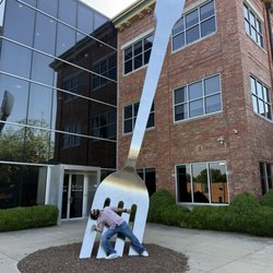
Everyone is from somewhere and the famous astronomer Edwin Hubble spent some of his boyhood here in Marshfield and is related to some residents of the area. From the plaque, "This scale model of the Hubble Space Telescope now orbiting earth is dedicated to Edwin Hubble, a native of Marshfield. Born November 20 1889, Died September 28, 1953." "Edwin Hubble was the 20th century's outstanding astronomer. In observations made in the 1920s and 1930s he discovered the expansion of the universe. Hubble opened the world of galaxies for science when he showed that spiral nebular beyond the Milky Way are galaxies extending to the limit of the universe and participating in a general expansion of the cosmos. The exploding universe of Hubble, now termed the Big Bang, determined the origin of the elements, of galaxies and of the stars." "His exploits in the world of science let to the launching of the Hubble Space Telescope in 1990 which is probing to the very edge of space." [Review 632 of 2024 - 326 in Missouri - 21663 overall] read more


More info about Hubble Telescope Replica Statue


Hubble Telescope Replica Statue - landmarks - Updated July 2026
Best of Marshfield
People found Hubble Telescope Replica Statue by searching for…
Things to Do in Marshfield, Missouri
Attractions in Marshfield, Missouri
Places to Take Pictures in Marshfield, Missouri
Photo Spots in Marshfield, Missouri
Historical Sites in Marshfield, Missouri
Scenic Overlook in Marshfield, Missouri
Star Gazing in Marshfield, Missouri
Tourist Attractions in Marshfield, Missouri
View Points in Marshfield, Missouri
Public Services & Government in Marshfield, Missouri
Night View in Marshfield, Missouri
Sightseeing in Marshfield, Missouri
Landmarks in Marshfield, Missouri
Scenic View in Marshfield, Missouri
Places to Walk Around in Marshfield, Missouri
Museums in Marshfield, Missouri
Stuff to Do in Marshfield, Missouri
Stargazing in Marshfield, Missouri
Field Trips in Marshfield, Missouri
Fun Things to Do With Kids in Marshfield, Missouri
Things to See in Marshfield, Missouri
Venues in Marshfield, Missouri
Trending Searches in Marshfield, MO
Boat Rental near Hubble Telescope Replica Statue
Caves near Hubble Telescope Replica Statue
Day Trips near Hubble Telescope Replica Statue
Fireworks near Hubble Telescope Replica Statue
Flower Fields near Hubble Telescope Replica Statue
Kayak Rental near Hubble Telescope Replica Statue
Landmarks & Historical Buildings near Hubble Telescope Replica Statue
Picnic Areas near Hubble Telescope Replica Statue
Places To Swim near Hubble Telescope Replica Statue
Places To Walk Around near Hubble Telescope Replica Statue
Public Pools near Hubble Telescope Replica Statue
River Swimming near Hubble Telescope Replica Statue
Secluded Spots near Hubble Telescope Replica Statue
Splash Pad near Hubble Telescope Replica Statue
Strawberry Picking near Hubble Telescope Replica Statue
Swimming Holes near Hubble Telescope Replica Statue
Swimming Lakes near Hubble Telescope Replica Statue
Things To Do This Weekend near Hubble Telescope Replica Statue
Browse Articles
Browse Nearby
BEST of Marshfield, Missouri Parks near Hubble Telescope Replica Statue
BEST of Marshfield, Missouri Restaurants near Hubble Telescope Replica Statue
BEST of Marshfield, Missouri Things to Do near Hubble Telescope Replica Statue
BEST of Marshfield, Missouri Coffee near Hubble Telescope Replica Statue
BEST of Marshfield, Missouri Hotels near Hubble Telescope Replica Statue
BEST of Marshfield, Missouri Museums near Hubble Telescope Replica Statue
BEST of Marshfield, Missouri Breakfast near Hubble Telescope Replica Statue
BEST of Marshfield, Missouri Campgrounds near Hubble Telescope Replica Statue
BEST of Marshfield, Missouri Day Trips near Hubble Telescope Replica Statue
Browse Brands
Related Searches in Marshfield, MO
Best Fishing Locations and Guides in Marshfield, Missouri
Best Fun Things to Do in Marshfield, Missouri
Book Engaging Historical Tours in Marshfield, Missouri
Discover Charming Historic Homes in Marshfield, Missouri
Discover Family-Friendly Aquariums in Marshfield, Missouri
Discover Famous Monuments in Marshfield, Missouri
Discover Popular Landmarks in Marshfield, Missouri
Discover Popular Photo Spots in Marshfield, Missouri
Discover the Best Caves to Explore in Marshfield, Missouri
Discover the Best Planetarium Shows in Marshfield, Missouri
Enjoy Arts & Entertainment in Marshfield, Missouri
Enjoy Hiking Adventures in Marshfield, Missouri
Enjoy the Best Walking Trails in Marshfield, Missouri
Explore Beautiful Parks and Green Spaces in Marshfield, Missouri
Explore Family-Friendly Zoos and Wildlife in Marshfield, Missouri
Explore Free Kids Activities Near Marshfield, Missouri
Explore Free Things to Do Around Marshfield, Missouri
Explore Fun Activities to Do in Marshfield, Missouri
Explore Fun Field Trips in Marshfield, Missouri
Explore Popular Scenic Overlook Points in Marshfield, Missouri
Explore Scenic Lakes to Visit in Marshfield, Missouri
Explore Secret Spots Worth Visiting in Marshfield, Missouri
Explore Top Art Galleries Located in Marshfield, Missouri
Explore Top History Museums in Marshfield, Missouri
Explore Top Things to Do at Night in Marshfield, Missouri
Explore Venues & Event Spaces in Marshfield, Missouri
Explore the Top Car Museum in Marshfield, Missouri
Find Beautiful Views in Marshfield, Missouri
Find Exciting Tours to Take in Marshfield, Missouri
Find Top Art Museums in Marshfield, Missouri
Find Top Libraries to Visit in Marshfield, Missouri
Find a Public Library Near You in Marshfield, Missouri
Find the Best Playgrounds to Visit in Marshfield, Missouri
Fun Rainy Day Activities to Try in Marshfield, Missouri
Must-See Tourist Attractions Around Marshfield, Missouri
Popular Kids Activities in Marshfield, Missouri
Popular Outdoor Activities to Try in Marshfield, Missouri
Popular Places to Take Pictures in Marshfield, Missouri
Popular Things to Do in Marshfield, Missouri
Popular Things to See in Marshfield, Missouri
Public Services & Government Offices in Marshfield, Missouri
Relax at Natural Hot Springs Near Marshfield, Missouri
See Top Fireworks Events in Marshfield, Missouri
Top Entertainment Options in Marshfield, Missouri
Top Hiking Trails to Explore in Marshfield, Missouri
Top Historic Restaurants to Try in Marshfield, Missouri
Tour Famous Lighthouses Located in Marshfield, Missouri
Visit Beautiful Gardens in Marshfield, Missouri
People who viewed Hubble Telescope Replica Statue also viewed
Webster County
1 review
Webster County of
1 review
Library Center
18 reviews
$
The Library Station
9 reviews
Schweitzer Brentwood Branch Library
5 reviews
Glenstone Title Office
15 reviews
Midtown Carnegie Branch Library
4 reviews
Springfield-Greene County Health Department
1 review
Springfield Fire Station #6
1 review