High Peaks Trail Photos


You might also consider
More like High Peaks Trail
Recommended Reviews - High Peaks Trail
Start your review...

Absolutely amazing trail that I've done twice in 100° weather. The views are great, and the trail is well groomed. But, oh my god, it is straight uphill. With extreme heat I literally thought I was going to die. Do it in the winter. read more


one of the many, many wonderful trails at pinnacles nat'l park. from the apex, you can see almost the entire park on a clear day, the beautiful balconies, ridges, forestry and wildlife that belongs to pinnacles. you can access this trail from: +west side: chaparral trailhead parking lot, 1.8mi hike to western trailhead of high peaks +east side: old pinnacles trailhead, 1.3mi hike to eastern trailhead of high peaks +east/south side: bear gulch parking lot, 0.5mi to southern trailhead of high peaks we chose to start from the east side, hike the old pinnacles trail to balconies, break at the chaparral trailhead for lunch, then return east via the high peaks trail. this was a TOUGH climb up, especially since it was only a little after noon, the sun was strong, and we'd already hiked 4+ miles from the east. many breaks were taken, call it "photo pace" hiking, and after some time, we finally reached the western side of the high peaks trail...more climbing awaited us, as did awesome views of this treasured park. there were many switchbacks, each turn offering a different view, so of course, i had to pause each time to snap a pic! there are no restrooms, water fountains, or other amenities here. due to the time of day we were here, there also wasn't much shade. definitely bring plenty of water, wear a hat, sunscreen, and light clothing if coming here during summer/autumn months. read more


3 years ago
COMBO HIKE to get the most out of this hike. It's a combo with High Peaks and Bear Gulch Cave Trail. The total loop is 6.5 miles and it took us about 6 hours to complete. We started at 6:30am because we heard parking can be rough and a lot of people come here. When we got there around that time, it was still pretty dark so we ate a little breakfast to go in the car and there were only 3 other cars there. Once we finished the hike (around 12:45pm), the parking lot was completely filled and there were even cars parked illegally. Across the street from the parking lot, there's a bathroom. I highly recommend using the bathroom before you start. There's a small crossing bridge (see pics) and that's the start of the hike. Again, recommend going this way because it's a lot easier. Difficulty level: modern (smooth areas, climbing stairs where you need to use the railings, gravel path, steep areas but not too difficult) Things to remember & bring: -go early to avoid crowds and easy parking -bring hiking sticks but not required (just made things a little easier) -bring headlamps for the cave! You'll need it -bring lunch (we ate it at the reservoir & it was so relaxing because it's calm, suns out but there's shade & just nice view...another reason why we started on Condor Trail around the loop and ended at Bear Gulch Cave Trail) -light jacket because it is cold at the top (dependent on the time of month you hike this) This hike was very diverse and had a little bit of everything from rocks, smooth walkway, stairs, downhill, caves, etc). I highly recommend completing this one hike with the addition of Bear Gulch Cave Trail. It's a nice way to end the day/hike. read more


 - Hiking Near Me - Paicines, California")


 - Hiking Near Me - Paicines, California")

1 year ago
1 year ago
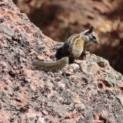
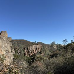
This is to review the continuous hiking trail that comprises Blue Oaks Trail (2.0 miles), High Peaks Trail (0.6 miles), and a part of High Peaks Trail named, "steep and narrow section" by the map provided at the Visitor's Center. This steep and narrow section consists of a narrow stone area having steps carved out of the volcanic stone, where this narrow area includes a steel bannister. The steel bannister is needed to prevent hikers from falling to their doom. Once you have hiked up the northern half of High Peaks Trail and have reached the top, it is not clear how to get back down. At the top, there is an unmarked trail (it has no name) that leads 50-feet down to a viewing point and then stops. Also at the top are two trails that take you down into Juniper Canyon and to the parking lot at the west entrance. To hike back down to parking lot, you need to find a tiny little trail sign that reads, "BEAR GULCH" and then take that trail. On six different occasions during the past ten years, I have hiked the entire High Peaks Trail, each time starting from the parking lot near the trailhead for Condor Gulch Trail or from the parking lot near the trailhead for Blue Oaks Trail. High Peaks Trail provides a comfortable aerobic workout. In my experience, the steepest hikes in the S.F. Bay area can be found on West Ridge Trail in Tilden Park. But High Peaks Trail never gets this steep. My attached photographs include photos of: (1) Lichen growing on rocks next to Blue Oaks Trail. (2) "Old Man's Beard" (a lichen) hanging from trees near Blue Oaks Trail. This lichen is also called beard lichen of the genus Usnea. Photographs of beard lichens are available from, "pointreyesnature dot com/alamea-trail." Colorful lichens that grow on rocks include, Xanthoria elegans, Rhizoplaca melanopthalma, and Saxicolous lichens. (3) View from High Peaks Trail of Balconies in the distance to the north. (4) Photograph of me posing near the edge of High Peaks Trail. (5) Photo of a hiker on the "steep and narrow section" w/ metal bannisters. (6) Trail sign showing where Condor Gulch Tr. meets High Peaks Tr. (7) Indian Warrior plants at the edge of Blue Oaks Trail. Indian Warrior is a parasitic plant that thrives by attaching itself to the roots of manzanita. Manzanita shrubs grow near Blue Oaks Trail. (8) Stone formation resembling a 100-foot tall stone hand with fingers pointing upwards. This formation is part of Hawkins Peak, and it is best viewed from Condor Gulch Trail. (9) Mountain goat near top of High Peaks Trail. This same mountain goat is on my YELP reviews for Golden Spike Trail, Bolinas Ridge Trail, and Tomales Point Trail. HOW PINNACLES CAME TO BE. Between 22-23 million years ago, volcanoes erupted in southern California at a location called, Neenach, in the Mojave Desert. The result was a huge area of volcanos, situated on both sides of the Pacific Plate and North American Plate. Over the course of the past 20 million years, these two plates have continued to move, relative to each other. The result was that the volcanoes destined to become Pinnacles National Park split off, and moved northwards at a rate of one to three centimeters per year. The term "split rate" is used to describe this movement. San Andreas Fault occurs at the meeting point between these two plates. Neenach Volcano is located in Los Angeles County, seven miles east of Route 5. To view the big picture, the mountains in Pinnacles Nat'l. Park used to be located in what is now Los Angeles County. REFERENCES (1) John Sims. Chronology of Displacement on the San Andreas Fault in Central California. Dept. of the Interior. U.S. Geological Survey (43 pages). (2) Frank De Courten. Geology of Southern California. Dept. Earth Sciences, Sierra College (48 pages). (3) Robert J. Keiffer (2012) Indian Warriors Welcome Spring at HREC. University of California Hopland Research and Extension Center. (4) Toni Corelli (Botanist, Curator Emeritus of the Carl Sharsmith Herbarium) Plants That Like Hosts. (5) K. Knudsen and T. Carlberg (2005) Bulletin of the California Lichen Society. Vol. 12, No. 2, page 36. read more


 near top of High Peaks Trail. My T-shirt is printed with my photo from Joshua Tree Nat'l. Park. - Hiking Near Me - Paicines, California")

 hiking near the highest part of High Peaks Trail. - Hiking Near Me - Paicines, California")


More info about High Peaks Trail
5000 CA-146
Paicines, CA 95043
Directions
Hours
Outdoor Amenities
Ask the Community - High Peaks Trail


High Peaks Trail - hiking - Updated May 2026
Best of Paicines
People found High Peaks Trail by searching for…
Stairs Workout in Paicines, CA
Stair Climbing in Paicines, CA
Visitor Centers in Paicines, CA
Places to Take Pictures in Paicines, CA
Off Road Trails in Paicines, CA
Waterfall Hike in Paicines, CA
Beautiful Views in Paicines, CA
Places to Visit in Paicines, CA
Running Trails in Paicines, CA
Walking Trails in Paicines, CA
Running Stairs in Paicines, CA
People who viewed High Peaks Trail also viewed
Chalone Peak Trail Pinnacles
1 review
Schmidt Guide Service
29 reviews
Bear Gulch Reservoir
1 review
Natividad Creek Dog Park
15 reviews
Salinas Skate Park
6 reviews
Twin Creeks Golf Course
15 reviews
Panoche Hills
1 review
Salinas Fairways Golf Course
33 reviews
Kasey's Fitness Academy
11 reviews
Salinas Valley MMA
6 reviews