Hamden Historical Marker Photos


More like Hamden Historical Marker
Recommended Reviews - Hamden Historical Marker
Start your review...

What do Henry Ford's use of assembly line production, Samuel Colt's popularization of interchangeable parts, and Philadelphia's Betsy Ross Bridge have in common? The answer is Hamden, CT. This is a two-sided marker from the CT Historical Commission in the familiar white lettering on a blue background. It has the same inscription on both sides, and is located in the heart of Hamden in a small grassy area at the busy intersection of Dixwell Avenue and Whitney Avenue. It's in excellent condition with a bright blue background and crisp white lettering. The marker is dated 1973, so I wonder if it was replaced somewhere along the way? The inscription reads: Hamden Incorporated in 1786, this town was originally part of New Haven and was named for John Hampden, noted English statesman. In 1798, at the foot of Lake Whitney, Eli Whitney pioneered in the use of interchangeable parts in the manufacture of arms for the United States Government and created the American concept of assembly line production. The first truss bridge in the United States, constructed after the patented design of Ithiel Town, eminent architect, was erected in Whitneyville in 1823. The Farmington Canal, 1825 - 1848, traversed the entire length of Hamden and evidence of it still exists in the Mount Carmel area. Erected by The Hamden Historical Society, Inc. and the Connecticut Historical Commission 1973 read more


More info about Hamden Historical Marker


Hamden Historical Marker - landmarks - Updated June 2026
Best of Hamden
People found Hamden Historical Marker by searching for…
Places to Take Pictures in Hamden, Connecticut
Fun Things to Do in Hamden, Connecticut
Free Things to Do in Hamden, Connecticut
Scenic View in Hamden, Connecticut
Public Services & Government in Hamden, Connecticut
State Park in Hamden, Connecticut
Field Trips in Hamden, Connecticut
Photo Spots in Hamden, Connecticut
View Points in Hamden, Connecticut
Attractions in Hamden, Connecticut
Hidden Gems in Hamden, Connecticut
Night View in Hamden, Connecticut
Boardwalk in Hamden, Connecticut
Landmarks in Hamden, Connecticut
Scenic Spots in Hamden, Connecticut
Waterfall in Hamden, Connecticut
Historical Sites in Hamden, Connecticut
Date Ideas in Hamden, Connecticut
Tourist Attractions in Hamden, Connecticut
Scenic Drive in Hamden, Connecticut
Trending Searches in Hamden, CT
Black Owned Nail Salons near Hamden Historical Marker
Boardwalk near Hamden Historical Marker
Boat Rental near Hamden Historical Marker
Caves near Hamden Historical Marker
Cliff Jumping near Hamden Historical Marker
Day Trips near Hamden Historical Marker
Fireworks near Hamden Historical Marker
Fishing Spots near Hamden Historical Marker
Flower Fields near Hamden Historical Marker
Hidden Gems near Hamden Historical Marker
Historical Sites near Hamden Historical Marker
Jet Ski Rental near Hamden Historical Marker
Kayak Rental near Hamden Historical Marker
Landmarks & Historical Buildings near Hamden Historical Marker
Picnic Areas near Hamden Historical Marker
Places To Visit near Hamden Historical Marker
Public Pools near Hamden Historical Marker
River Swimming near Hamden Historical Marker
Scenic Restaurants near Hamden Historical Marker
Secluded Spots near Hamden Historical Marker
Sightseeing near Hamden Historical Marker
Soccer Store near Hamden Historical Marker
Splash Pad near Hamden Historical Marker
Strawberry Picking near Hamden Historical Marker
Swimming Holes near Hamden Historical Marker
Swimming Lakes near Hamden Historical Marker
Things To Do This Weekend near Hamden Historical Marker
Things To See near Hamden Historical Marker
Browse Articles
Browse Nearby
BEST of Hamden, Connecticut Restaurants near Hamden Historical Marker
BEST of Hamden, Connecticut Coffee near Hamden Historical Marker
BEST of Hamden, Connecticut Things to Do near Hamden Historical Marker
BEST of Hamden, Connecticut Breakfast near Hamden Historical Marker
BEST of Hamden, Connecticut Photo Spots near Hamden Historical Marker
BEST of Hamden, Connecticut Scenic Drive near Hamden Historical Marker
BEST of Hamden, Connecticut Hotels near Hamden Historical Marker
BEST of Hamden, Connecticut Campgrounds near Hamden Historical Marker
Browse Brands
Related Searches in Hamden, CT
Best Fun Things to Do in Hamden, Connecticut
Best Lookout Points to Visit in Hamden, Connecticut
Best Observation Deck Views in Hamden, Connecticut
Best Waterfalls and Swimming Holes in Hamden, Connecticut
Book Engaging Historical Tours in Hamden, Connecticut
Discover Charming Historic Homes in Hamden, Connecticut
Discover Historic Sites and Places in Hamden, Connecticut
Discover Popular Landmarks in Hamden, Connecticut
Discover Popular Photo Spots in Hamden, Connecticut
Discover Stunning Skyline View Spots in Hamden, Connecticut
Discover the Best Beaches in Hamden, Connecticut
Discover the Best Interactive Museum in Hamden, Connecticut
Enjoy the Best Walking Trails in Hamden, Connecticut
Enjoy the Scenic Boardwalk Attractions in Hamden, Connecticut
Experience Stunning Sunset Views in Hamden, Connecticut
Explore Beautiful Botanical Gardens in Hamden, Connecticut
Explore Beautiful Castles and Landmarks in Hamden, Connecticut
Explore Beautiful Parks and Green Spaces in Hamden, Connecticut
Explore Children's Museums Near Hamden, Connecticut
Explore Free Things to Do Around Hamden, Connecticut
Explore Fun Activities to Do in Hamden, Connecticut
Explore Popular Scenic Overlook Points in Hamden, Connecticut
Explore Popular Scenic Views Near Hamden, Connecticut
Explore Popular View Points Around Hamden, Connecticut
Explore Secret Spots Worth Visiting in Hamden, Connecticut
Explore Top Art Galleries Located in Hamden, Connecticut
Explore Venues & Event Spaces in Hamden, Connecticut
Find Beautiful Views in Hamden, Connecticut
Find Top Art Museums in Hamden, Connecticut
Find Top Libraries to Visit in Hamden, Connecticut
Find a Public Library Near You in Hamden, Connecticut
Find the Best Bridge Spots in Hamden, Connecticut
Find the Best Playgrounds to Visit in Hamden, Connecticut
Fun Rainy Day Activities to Try in Hamden, Connecticut
Hiking Trails With Waterfalls in Hamden, Connecticut
Must-See Tourist Attractions Around Hamden, Connecticut
Popular Picnic Spots to Visit in Hamden, Connecticut
Popular Places to Take Pictures in Hamden, Connecticut
Popular Things to Do in Hamden, Connecticut
Popular Things to See in Hamden, Connecticut
Top Hiking Trails to Explore in Hamden, Connecticut
Top Historic Restaurants to Try in Hamden, Connecticut
Top Museums for Kids to Visit in Hamden, Connecticut
Top Places to Visit in Hamden, Connecticut for Sightseeing
Top Things to Do With Kids in Hamden, Connecticut
Visit Beautiful Gardens in Hamden, Connecticut
Visit Popular Museums in Hamden, Connecticut Now
Visit a Charming Gift Shop in Hamden, Connecticut
People who viewed Hamden Historical Marker also viewed
Wallingford World War I Monument
1 review
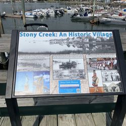
Guilford Historical Marker
1 review
Branford Historical Marker
1 review
Meriden's Traffic Tower
1 review
Ancient Trading Path
1 review
High Street Arch
1 review
Waterbury Civil War Monument
1 review
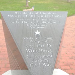
Prospect Historical Society
1 review
Abraham Lincoln Monument
1 review
John Fitzgerald Kennedy Marker
2 reviews