Guler Ice Caves Photos


More like Guler Ice Caves
Recommended Reviews - Guler Ice Caves
Start your review...

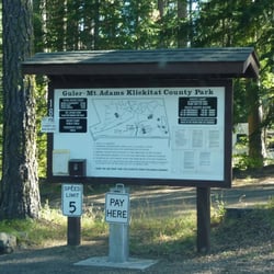
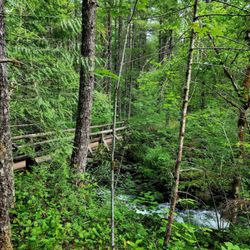
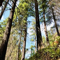
More than just a hole in the ground, the Guler Ice Caves are a hidden gem located a few miles southwest of Trout Lake along NF-24 in the Gifford-Pinchot. It's a day-use site (re: $5, no camping allowed) with a small packed-dirt parking area, a few trails and picnic tables, and the aforementioned caves, which are situated just to the left (re: east) of the parking area as you enter, which is not immediately apparent, especially if there are cars already parked there; for some reason, no signs in the immediate area point you in the right direction, so you may struggle to find it, if you don't know where to look. Below ground level, the caves act as a heat trap, keeping temperatures at or below freezing all-year round: even on an 85 degree day like the one during our visit, the cave is absolutely frigid, slick, and somewhat dangerous to traverse, and more extensive than it first appears. You might be tempted to believe that the semi-circular chamber just below the entrance stairs is all there is to the cave system, but a careful look at the map on the marker display above reveals deeper, more exciting chambers, such as the crystal grotto, further in either direction. Hard-hats, boots with good traction, flashlights, cold-weather clothing, and probably knee-pads (in case of highly likely slips, trips and falls) are recommended beyond the main chamber. I've been wanting to visit here for some time, but as we were inadequately prepared for the environment, we did not venture far beyond the entrance; a mistake I guarantee will be corrected during our next visit. Also important to note that the caves are virtually inaccessible during the winter without some sort of vehicle capable of traversing heavy snow, as we encountered last April during an attempted visit, only to find the roads completely blocked by a wall of ice and snow. Wait until late spring or early summer, when the snowpack has melted, before trying to visit in a car or truck. read more


More info about Guler Ice Caves


Guler Ice Caves - hiking - Updated May 2026
Best of Trout Lake
People found Guler Ice Caves by searching for…
Swimming Holes in Trout Lake, WA
Things to Do in Trout Lake, WA
Secret Spots in Trout Lake, WA
Waterfall Hike in Trout Lake, WA
Hiking Trails in Trout Lake, WA
Scenic Overlook in Trout Lake, WA
Secluded Spots in Trout Lake, WA
Picnic Areas in Trout Lake, WA
Off Road Trails in Trout Lake, WA
Free Campgrounds in Trout Lake, WA
Parks for Picnics in Trout Lake, WA
Picnic Spots in Trout Lake, WA
Tent Camping in Trout Lake, WA
Off Leash Dog Hikes in Trout Lake, WA
Trending Searches in Trout Lake, WA
Browse Articles
Browse Nearby
BEST of Trout Lake, Washington Things to Do near Guler Ice Caves
BEST of Trout Lake, Washington Coffee near Guler Ice Caves
BEST of Trout Lake, Washington Parks near Guler Ice Caves
BEST of Trout Lake, Washington Lakes near Guler Ice Caves
BEST of Trout Lake, Washington Restaurants near Guler Ice Caves
BEST of Trout Lake, Washington Hotels near Guler Ice Caves
BEST of Trout Lake, Washington Breakfast near Guler Ice Caves
BEST of Trout Lake, Washington Campgrounds near Guler Ice Caves
Browse Brands
Related Searches in Trout Lake, WA
Best Lookout Points to Visit in Trout Lake, Washington
Best Nature Trails for Hiking in Trout Lake, Washington
Best Places for Horseback Riding in Trout Lake, Washington
Best Spots for Star Gazing in Trout Lake, Washington
Check Out Off Road Trails in Trout Lake, Washington
Discover Dog Friendly Beaches Near Trout Lake, Washington
Discover Scenic Mountain Bike Trails Near Trout Lake, Washington
Discover Top Nature Parks to Visit in Trout Lake, Washington
Discover a Hiking Trail in Trout Lake, Washington
Discover the Best Night Hike Trails in Trout Lake, Washington
Discover the Best Running Track in Trout Lake, Washington
Dog-Friendly Hikes With Dogs in Trout Lake, Washington
Effective Stairs Workout Spots in Trout Lake, Washington
Enjoy Camping Adventures Around Trout Lake, Washington
Enjoy River Tubing Adventures in Trout Lake, Washington
Enjoy Scenic Night View Experiences in Trout Lake, Washington
Enjoy Tent Camping Spots Around Trout Lake, Washington
Enjoy the Best Night View Spots in Trout Lake, Washington
Enjoy the Best Picnic Spots and Ideas in Trout Lake, Washington
Enjoy the Best Walking Trails in Trout Lake, Washington
Exciting Cliff Jumping Spots in Trout Lake, Washington
Experience Stunning Sunset Views in Trout Lake, Washington
Explore Beautiful Parks and Green Spaces in Trout Lake, Washington
Explore Bike Rentals Throughout Trout Lake, Washington
Explore Popular Campgrounds Near Trout Lake, Washington
Explore Popular RV Parks Around Trout Lake, Washington
Explore Popular Scenic Overlook Points in Trout Lake, Washington
Explore Popular View Points Around Trout Lake, Washington
Explore Scenic Lakes to Visit in Trout Lake, Washington
Explore Secret Spots Worth Visiting in Trout Lake, Washington
Explore the Best Trail Options in Trout Lake, Washington
Find Beautiful Views in Trout Lake, Washington
Find Fun Kids Activities Outdoor in Trout Lake, Washington
Find Parks and Recreation Activities in Trout Lake, Washington
Find Top Dog Friendly Parks to Visit in Trout Lake, Washington
Find the Best Parks for Picnics in Trout Lake, Washington
Find the Best Scenic View Locations in Trout Lake, Washington
Find the Best Swimming Pools in Trout Lake, Washington Today
Off Leash Dog Hiking Trails in Trout Lake, Washington
Picnic Areas With BBQ Pits Available in Trout Lake, Washington
Plan Nature Center Visits in Trout Lake, Washington
Plan a Scenic Drive Route Near Trout Lake, Washington
Popular Fishing Spots to Explore in Trout Lake, Washington
Popular Picnic Spots to Visit in Trout Lake, Washington
Popular Places to Take Pictures in Trout Lake, Washington
Popular Things to Do in Trout Lake, Washington
Safe River Swimming Areas in Trout Lake, Washington
Safe and Fun Parks for Kids in Trout Lake, Washington
People who viewed Guler Ice Caves also viewed
Lewis River Falls
15 reviews
Panther Creek Falls
1 review
Children’s Park
6 reviews
Rowland Lake
1 review
Catherine Creek Trail
10 reviews
Brimstone Boulders
5 reviews
Trailhead: South Climb
1 review
Zoller's Outdoor Odysseys
148 reviews
Brian's Windsurfing Kiteboarding SUP
22 reviews
Columbia River Outdoors
6 reviews