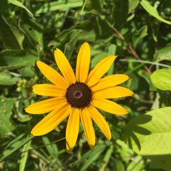
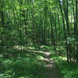
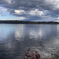
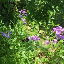
Greenport Conservation Area Photos


More like Greenport Conservation Area
Recommended Reviews - Greenport Conservation Area
Start your review...

Always a great walk, no matter the time of year. There is an accessible walking path and several regular (traditional) trails. The views over the Hudson River are lovely, as are the sporadic pieces of art and the many birds. read more


7 years ago
A well located walk if your staying in Hudson and have a car. There are wonderful walks through large fields and towards views of the Hudson. Also a popular place for dog walking. Excellent for all seasons read more

More info about Greenport Conservation Area
54 Daisy Hill Rd
Lorenz Park, NY 12534
Directions
(518) 392-5252
Call Now
Visit Website
http://clctrust.org/public-conservation-areas/greenport
Hours
Outdoor Amenities
From the Business
Ask the Community - Greenport Conservation Area


Greenport Conservation Area - hiking - Updated May 2026
Best of Lorenz Park
People found Greenport Conservation Area by searching for…
Hiking Trails in Lorenz Park, New York
Waterfall Hike in Lorenz Park, New York
Picnic Areas in Lorenz Park, New York
Sunrise View in Lorenz Park, New York
Things to Do With Kids in Lorenz Park, New York
Scenic View in Lorenz Park, New York
Fun Things to Do at Night in Lorenz Park, New York
Kid Friendly Hiking Trails in Lorenz Park, New York
Picnic Spots in Lorenz Park, New York
Walking Trails in Lorenz Park, New York
Hiking With Kids in Lorenz Park, New York
Off Leash Dog Hikes in Lorenz Park, New York
Running Trails in Lorenz Park, New York
Dog Friendly Trails in Lorenz Park, New York
Places to Take Pictures in Lorenz Park, New York
Stroller Walk in Lorenz Park, New York
Things to Do Alone in Lorenz Park, New York
Fall Foliage in Lorenz Park, New York
Trail in Lorenz Park, New York
Off Road Trails in Lorenz Park, New York
Lakes & Ponds in Lorenz Park, New York
Picnic Tables in Lorenz Park, New York
Trending Searches in Lorenz Park, NY
Botanical Gardens near Greenport Conservation Area
Bounce House Rentals near Greenport Conservation Area
Campgrounds near Greenport Conservation Area
Cheap Plants near Greenport Conservation Area
Cliff Jumping near Greenport Conservation Area
Floral Designers near Greenport Conservation Area
Flower Shop near Greenport Conservation Area
Garage Sales near Greenport Conservation Area
Garden Center near Greenport Conservation Area
Lakes & Ponds near Greenport Conservation Area
Mens Suits near Greenport Conservation Area
Nurseries & Gardening near Greenport Conservation Area
Outdoor Activities near Greenport Conservation Area
Outdoor Furniture Stores near Greenport Conservation Area
Parks near Greenport Conservation Area
Pedicure near Greenport Conservation Area
Photo Spots near Greenport Conservation Area
Pick Your Own Farms near Greenport Conservation Area
Places To Take Pictures near Greenport Conservation Area
Plant Nursery near Greenport Conservation Area
Browse Articles
Browse Nearby
BEST of Lorenz Park, New York Coffee near Greenport Conservation Area
BEST of Lorenz Park, New York Restaurants near Greenport Conservation Area
BEST of Lorenz Park, New York Things to Do near Greenport Conservation Area
BEST of Lorenz Park, New York Walking Trails near Greenport Conservation Area
BEST of Lorenz Park, New York Parks near Greenport Conservation Area
BEST of Lorenz Park, New York Breakfast near Greenport Conservation Area
BEST of Lorenz Park, New York Hotels near Greenport Conservation Area
BEST of Lorenz Park, New York Taxis near Greenport Conservation Area
Browse Brands
Related Searches in Lorenz Park, NY
Affordable Kayak Rental Services in Lorenz Park, New York
Best Fishing Locations and Guides in Lorenz Park, New York
Best Fun Things to Do in Lorenz Park, New York
Best Lookout Points to Visit in Lorenz Park, New York
Best Places for Horseback Riding in Lorenz Park, New York
Check Out Off Road Trails in Lorenz Park, New York
Discover Dog Friendly Trails to Explore in Lorenz Park, New York
Discover Lakes & Ponds to Explore in Lorenz Park, New York
Discover Popular Photo Spots in Lorenz Park, New York
Discover Top Boat Tours in Lorenz Park, New York for All Ages
Discover a Hiking Trail in Lorenz Park, New York
Discover the Best Night Hike Trails in Lorenz Park, New York
Dog-Friendly Hikes With Dogs in Lorenz Park, New York
Enjoy Kayaking Adventures in Lorenz Park, New York
Enjoy a Beautiful Waterfall Hike in Lorenz Park, New York
Enjoy the Best Tubing Experiences in Lorenz Park, New York
Exciting Cliff Jumping Spots in Lorenz Park, New York
Explore Beautiful Parks and Green Spaces in Lorenz Park, New York
Explore Bike Rentals Throughout Lorenz Park, New York
Explore Easy Hikes Perfect for All in Lorenz Park, New York
Explore Fun Activities to Do in Lorenz Park, New York
Explore Popular Campgrounds Near Lorenz Park, New York
Explore Popular RV Parks Around Lorenz Park, New York
Explore Scenic Lakes to Visit in Lorenz Park, New York
Explore Top Dog Parks in Lorenz Park, New York Near You
Explore Top Water Parks in Lorenz Park, New York Today
Explore the Best Boating Spots in Lorenz Park, New York
Explore the Best Swimming Holes Around Lorenz Park, New York
Family Friendly Hiking With Kids in Lorenz Park, New York
Find Popular Ziplining Spots Around Lorenz Park, New York
Find Top Skate Parks in Lorenz Park, New York for All Skill Levels
Find the Best Playgrounds to Visit in Lorenz Park, New York
Find the Best Scenic View Locations in Lorenz Park, New York
Hiking Trails With Waterfalls in Lorenz Park, New York
Must-See Tourist Attractions Around Lorenz Park, New York
Off Leash Dog Hiking Trails in Lorenz Park, New York
Perfect Spots to Watch Sunset in Lorenz Park, New York
Popular Kids Activities in Lorenz Park, New York
Popular Outdoor Activities to Try in Lorenz Park, New York
Popular Picnic Spots to Visit in Lorenz Park, New York
Popular Things to Do in Lorenz Park, New York
Top Climbing Spots and Gyms in Lorenz Park, New York
Top Fishing Charter Experiences in Lorenz Park, New York
Top Paddleboarding Activities in Lorenz Park, New York
Top Playgrounds for Kids to Enjoy in Lorenz Park, New York
Top Running Trails to Explore in Lorenz Park, New York
Top Swimming Lakes to Enjoy in Lorenz Park, New York
Top Swimming Spots and Pools in Lorenz Park, New York