Goat Lake Trail Photos


You might also consider
More like Goat Lake Trail
Recommended Reviews - Goat Lake Trail
Start your review...

Reviews With Photos


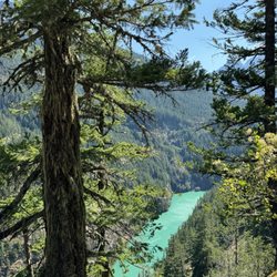
Completed this hike on a sunny Saturday in June. Arrived at the trailhead at 8:30am and the tiny lot was already full but there was still plenty of parking on the street. I took the lower Elliot loop to the Lake and the upper loop back to the parking lot. Definitely recommend doing it this way because the lower loop has a steady incline and many viewpoints & streams on the way up. The upper loop had more forest & foliage. read more


Came here on a Sunday morning, arriving to the parking lot around 8:30AM, parking lot was pretty full but there was plenty of parking space on the road. There's a bathroom at the trailhead. We took upper and came back down on lower, and the trail wasn't too steep either way. The path is pretty much fully under the shade from trees, and there are some views of the mountains here and there. The lake is beautiful with lots of spots to sit, and there were a lot of people camping there. Passed a lot of backpackers with big packs on the way up, saw some hikers as well. Stayed at the lake for a bit of time, and weather was beautiful. Not many bugs around which was good, water wasn't too cold either. Highly recommend, this is one of my favorite lakes in WA so far! read more

7 years ago
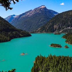
Hands down one of the best hikes I accomplished for 2019. This hike is easily accessible, parking isn't a problem if you arrive early in the AM, at the trail head. I highly recommend bringing a sack lunch and making a day for this. The lake views are incredible. I personally found the upper trail to be far more beautiful than the lower trail, but that's just me. The lower trail follows some of water and has less of an incline, hiking towards the lake. The upper trail has some beautiful scenic views of the nearby peaks. It's really based on your personal preference. Some photos of our day trip show the beauty of this location. I can't wait to get back out there. read more


Since Washington has an entire website dedicated to hiking and trail reports (WTA.org) not much is posted on Yelp about hiking trails. Here's my write up on WTA for Goat Lake: Backpacked: Saturday 7/8- Sunday 7/9 Took: Lower Elliot to Goat Lake, then Upper Elliot back to trailhead Hit trail at: Sat 7:45 am, got to lake at 10:30 am (2 hrs, 45 min) Cody and I left Seattle Saturday morning at 5:40 am for Goat Lake Trailhead. We got to the trailhead at 7:20 am! We wanted an early start because we had heard this trailhead can get crowded and we wanted a good spot to pitch our tent when we got to the lake. There were about 12 cars when we pulled in. We took Lower Elliot Trail to the lake and only crossed 1 man while going that route. We ran into more ppl once the trails connected again. We went a little off trail when the trail started gaining. Instead of going left of the uprooted tree, where someone has marked it with a cairn last I saw, we went right over some downed logs. I mean, both routes get you to the same place, and this route gets you closer to the waterfalls, but it's a rougher route. We found trail again, and shortly after got to the well marked sign that read campsites to the left, lake to the right. We were the first backpackers of the day up there, and around 10:45 am there were only about 3-4 tents set up, so we had prime picking for our tent. By 7 pm Saturday night though, about 25 tents had popped up. It was crowded with tents, but I never felt like there was a moment when ppl were of nuisance, or too loud. We set up camp, walked around the lake, and hammocked back at our campsite. Around 4 pm, we headed back to the lake to go swimming, and there were a handful of others swimming as well. From afar, we saw some mountain goats too! They were way far away on the slope of a mountain to the left, but still cool to spot. Next day, we packed up camp and hit the trail at 10:30 am, took Upper Elliot back, and got back to trailhead at 12:45 pm. the lake was beautiful, the trails were pretty dry, and another great backpacking trip for the books! read more


8 years ago
Hiked this trail mid September with my dog on a Wednesday. The forecast said rain, so I went prepared. A few mist and a few rain, I think that kept people from doing the hike or it's just that it's late in the season and mid week. The trail was in pretty good shape. Nothing too steep, a few inclines but very doable. WTA.org says it's an intermediate hike. The road to the trail can be reached by a car, a few potholes on the road there, but nothing too deep. There was no snow on the road. read more


This a gorgeous hike that is not too strenuous, but still makes you feel that you got a work out in. From seattle, it's about an hour to granite falls, then head east on mountain loop highway for 31 miles till the pavement ends and you hit the gravel road. Go about 3 more miles and you'll see the sign pointing you towards elliot and goat lake trail (careful while driving on the gravel road, there are potholes everywhere! Littered like land mines ready to destroy your car!). Try to get there early, we hit the trail head around 10am and there were already multiple cars lined up and at least 2-3 more people pulling in at the same time. Dogs are allowed, so definitely bring fido. My little corgi loved it there! Don't forget to get a northwest forest pass prior to arriving. I'm sure you can get a temporary one if you forget, but I'm not sure where you could purchase one. The hike is 10.4 miles roundtrip, but the elevation gain is only about 2400. It is a great gradual hike with not too many steep parts. You have two options to get to and from the lake, you can either take the upper or lower elliot trails. They both take you where you wanna go. We took the upper to the lake and then the lower back. I personally enjoyed the lower trail better because you were walking along a nice river most of the time. The upper trail was actually pretty boring. There were some parts that you could see out at the mountains, but not much else going on. Definitely pack a lunch or a snack, you'll want to sit down by goat lake for awhile before heading back. It's so serene and lovely. Bring bug spray and wear long pants! Mosquitos are everywhere and I believe I saw some poison oak on the trail. The hike to the lake was a little boring, but totally worth it for the view at the end. read more


7 years ago
More info about Goat Lake Trail
Darrington, WA 98241
Directions
Visit Website
http://www.wta.org/go-hiking/hikes/goat-lake
Hours
Indoor Amenities
Outdoor Amenities
Ask the Community - Goat Lake Trail


Goat Lake Trail - hiking - Updated May 2026
Best of Darrington
People found Goat Lake Trail by searching for…
Hiking Trails With Waterfalls in Darrington, Washington
Lakes in Darrington, Washington
Things to Do in Darrington, Washington
Campgrounds in Darrington, Washington
Swimming Lakes in Darrington, Washington
Scenic Drive in Darrington, Washington
Walking Trails in Darrington, Washington
River Swimming in Darrington, Washington
Dog Friendly Hiking Trails in Darrington, Washington
Scenic Overlook in Darrington, Washington
Scenic View in Darrington, Washington
Sunset View in Darrington, Washington
Waterfalls and Swimming Holes in Darrington, Washington
Waterfalls in Darrington, Washington
Lookout Points in Darrington, Washington
Night View in Darrington, Washington
Photo Spots in Darrington, Washington
Easy Hikes in Darrington, Washington
Sunrise View in Darrington, Washington
Off Road Trails in Darrington, Washington
Hiking With Kids in Darrington, Washington
View Points in Darrington, Washington
Trending Searches in Darrington, WA
Blueberry Picking near Goat Lake Trail
Botanical Gardens near Goat Lake Trail
Bounce House Rentals near Goat Lake Trail
Campgrounds near Goat Lake Trail
Cherry Picking near Goat Lake Trail
Cliff Jumping near Goat Lake Trail
Flower Fields near Goat Lake Trail
Flower Shop near Goat Lake Trail
Nurseries & Gardening near Goat Lake Trail
Outdoor Furniture Stores near Goat Lake Trail
Party Equipment Rentals near Goat Lake Trail
Photo Spots near Goat Lake Trail
Picnic Areas near Goat Lake Trail
Places To Take Pictures near Goat Lake Trail
Rock Quarry near Goat Lake Trail
Rv Rental near Goat Lake Trail
Spray Tanning near Goat Lake Trail
Browse Articles
Browse Nearby
BEST of Darrington, Washington Things to Do near Goat Lake Trail
BEST of Darrington, Washington Parks near Goat Lake Trail
BEST of Darrington, Washington Restaurants near Goat Lake Trail
BEST of Darrington, Washington Coffee near Goat Lake Trail
BEST of Darrington, Washington Campgrounds near Goat Lake Trail
BEST of Darrington, Washington Hotels near Goat Lake Trail
BEST of Darrington, Washington Photo Spots near Goat Lake Trail
BEST of Darrington, Washington Taxis near Goat Lake Trail
BEST of Darrington, Washington Breakfast near Goat Lake Trail
Browse Brands
Related Searches in Darrington, WA
Affordable Paddle Board Rental in Darrington, Washington
Best Fishing Locations and Guides in Darrington, Washington
Best Places for Horseback Riding in Darrington, Washington
Check Out Off Road Trails in Darrington, Washington
Discover Dog Friendly Beaches Near Darrington, Washington
Discover Dog Friendly Trails to Explore in Darrington, Washington
Discover Popular Photo Spots in Darrington, Washington
Discover Scenic Mountain Bike Trails Near Darrington, Washington
Discover Top Boat Tours in Darrington, Washington for All Ages
Discover a Hiking Trail in Darrington, Washington
Discover the Best Night Hike Trails in Darrington, Washington
Dog-Friendly Hikes With Dogs in Darrington, Washington
Enjoy Camping Adventures Around Darrington, Washington
Enjoy a Beautiful Waterfall Hike in Darrington, Washington
Enjoy the Best Tubing Experiences in Darrington, Washington
Enjoy the Best Walking Trails in Darrington, Washington
Exciting Cliff Jumping Spots in Darrington, Washington
Experience Stunning Sunset Views in Darrington, Washington
Explore Beautiful Parks and Green Spaces in Darrington, Washington
Explore Bike Rentals Throughout Darrington, Washington
Explore Easy Hikes Perfect for All in Darrington, Washington
Explore Family-Friendly Zoos and Wildlife in Darrington, Washington
Explore Popular Campgrounds Near Darrington, Washington
Explore Popular RV Parks Around Darrington, Washington
Explore Scenic Lakes to Visit in Darrington, Washington
Explore Secret Spots Worth Visiting in Darrington, Washington
Explore Top Dog Parks in Darrington, Washington Near You
Explore Top Water Parks in Darrington, Washington Today
Explore the Best Swimming Holes Around Darrington, Washington
Find Fun Things to Do With Kids in Darrington, Washington
Find Top Skate Parks in Darrington, Washington for All Skill Levels
Find Top-Rated Disc Golf in Darrington, Washington
Find the Best Playgrounds to Visit in Darrington, Washington
Find the Best Scenic View Locations in Darrington, Washington
Find the Best Swimming Pools in Darrington, Washington Today
Hiking Trails With Waterfalls in Darrington, Washington
Must-See Tourist Attractions Around Darrington, Washington
Off Leash Dog Hiking Trails in Darrington, Washington
Perfect Spots to Watch Sunset in Darrington, Washington
Popular Fishing Spots to Explore in Darrington, Washington
Popular Kids Activities in Darrington, Washington
Popular Places to Take Pictures in Darrington, Washington
Popular Things to Do in Darrington, Washington
Safe River Swimming Areas in Darrington, Washington
See Top Fireworks Events in Darrington, Washington
Top Fishing Charter Experiences in Darrington, Washington
Top Playgrounds for Kids to Enjoy in Darrington, Washington
Top Running Trails to Explore in Darrington, Washington