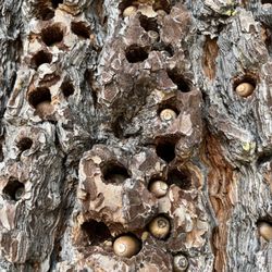
Foster Point Photos


You might also consider
More like Foster Point
Recommended Reviews - Foster Point
Start your review...

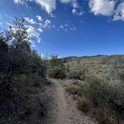
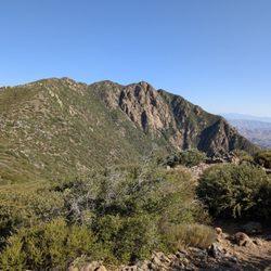
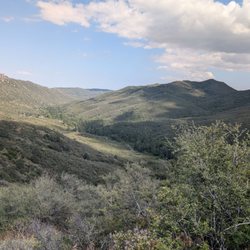
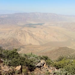
This is a hiking trail connecting Sunrise Highway to Foster Point on Pacific Crest Trail that offers great desert views. The trail entrance starts at the opposite side of Horse Heaven Campground Entrance. It's about 1.3 miles round trip read more


More info about Foster Point
You might also consider


Foster Point - hiking - Updated July 2026
Best of Mount Laguna
People found Foster Point by searching for…
Star Gazing in Mount Laguna, CA
Hiking Trails in Mount Laguna, CA
Things to Do in Mount Laguna, CA
Sand Dunes in Mount Laguna, CA
Meteor Shower in Mount Laguna, CA
Redwood Trees in Mount Laguna, CA
Bungee Jump in Mount Laguna, CA
Swimming Lakes in Mount Laguna, CA
Lookout Points in Mount Laguna, CA
Photo Spots in Mount Laguna, CA
Hammock Park in Mount Laguna, CA
Off Road Trails in Mount Laguna, CA
Waterfall Hike in Mount Laguna, CA
Fishing Spots in Mount Laguna, CA
Beautiful Views in Mount Laguna, CA
Lakes & Ponds in Mount Laguna, CA
Sunset View in Mount Laguna, CA
Running Trails in Mount Laguna, CA
Secret Spots in Mount Laguna, CA
Sunrise Hike in Mount Laguna, CA
Scenic Views in Mount Laguna, CA
Trending Searches in Mount Laguna, CA
Browse Articles
Browse Nearby
BEST of Mount Laguna, California Things to Do near Foster Point
BEST of Mount Laguna, California Restaurants near Foster Point
BEST of Mount Laguna, California Coffee near Foster Point
BEST of Mount Laguna, California Photo Spots near Foster Point
BEST of Mount Laguna, California Lakes near Foster Point
BEST of Mount Laguna, California Campgrounds near Foster Point
BEST of Mount Laguna, California Hot Springs near Foster Point
BEST of Mount Laguna, California Breakfast near Foster Point
Browse Brands
Related Searches in Mount Laguna, CA
Best Fishing Locations and Guides in Mount Laguna, California
Best Lookout Points to Visit in Mount Laguna, California
Best Nature Trails for Hiking in Mount Laguna, California
Best Places for Horseback Riding in Mount Laguna, California
Best Sledding Spots and Fun in Mount Laguna, California
Best Spots for Star Gazing in Mount Laguna, California
Check Out Off Road Trails in Mount Laguna, California
Discover Dog Friendly Beaches Near Mount Laguna, California
Discover Dog Friendly Trails to Explore in Mount Laguna, California
Discover Popular Bike Trails in Mount Laguna, California
Discover Popular Photo Spots in Mount Laguna, California
Discover Scenic Mountain Bike Trails Near Mount Laguna, California
Discover Top Nature Parks to Visit in Mount Laguna, California
Discover a Hiking Trail in Mount Laguna, California
Discover the Best Night Hike Trails in Mount Laguna, California
Dog-Friendly Hikes With Dogs in Mount Laguna, California
Effective Stairs Workout Spots in Mount Laguna, California
Enjoy Exciting Mountain Biking Adventures in Mount Laguna, California
Enjoy Scenic Night View Experiences in Mount Laguna, California
Enjoy Tent Camping Spots Around Mount Laguna, California
Enjoy the Best Tubing Experiences in Mount Laguna, California
Enjoy the Best Walking Trails in Mount Laguna, California
Exciting Cliff Jumping Spots in Mount Laguna, California
Explore Beautiful Parks and Green Spaces in Mount Laguna, California
Explore Bike Rentals Throughout Mount Laguna, California
Explore Easy Hikes Perfect for All in Mount Laguna, California
Explore Popular Campgrounds Near Mount Laguna, California
Explore Popular RV Parks Around Mount Laguna, California
Explore Popular Scenic Overlook Points in Mount Laguna, California
Explore Scenic Lakes to Visit in Mount Laguna, California
Explore the Best Swimming Holes Around Mount Laguna, California
Explore the Best Trail Options in Mount Laguna, California
Family Friendly Hiking With Kids in Mount Laguna, California
Find Beautiful Views in Mount Laguna, California
Find Fun Kids Activities Outdoor in Mount Laguna, California
Find the Best Parks for Picnics in Mount Laguna, California
Find the Best Scenic View Locations in Mount Laguna, California
Find the Best Swimming Pools in Mount Laguna, California Today
Hiking Trails With Waterfalls in Mount Laguna, California
Perfect Spots to Watch Sunset in Mount Laguna, California
Popular Fishing Spots to Explore in Mount Laguna, California
Popular Kids Activities in Mount Laguna, California
Popular Picnic Spots to Visit in Mount Laguna, California
Popular Things to Do in Mount Laguna, California
Relax at Natural Hot Springs Near Mount Laguna, California
Safe River Swimming Areas in Mount Laguna, California
See Top Fireworks Events in Mount Laguna, California
Top Running Trails to Explore in Mount Laguna, California
People who viewed Foster Point also viewed
Secret Canyon Trail
6 reviews
Stonewall Peak Trail
100 reviews
Santa Ysabel Preserves
35 reviews
Pacific Crest Trail At Penny Pines
22 reviews
Oakoasis County Preserve
19 reviews
Old Banner Toll Road
9 reviews
Slot Canyon
83 reviews
El Cajon Mountain Trail - South Ridge
1 review
Inaja Memorial Park
9 reviews
Sunrise Highway
12 reviews