El Capitan Photos


You might also consider
More like El Capitan
Recommended Reviews - El Capitan
Start your review...

Reviews With Photos

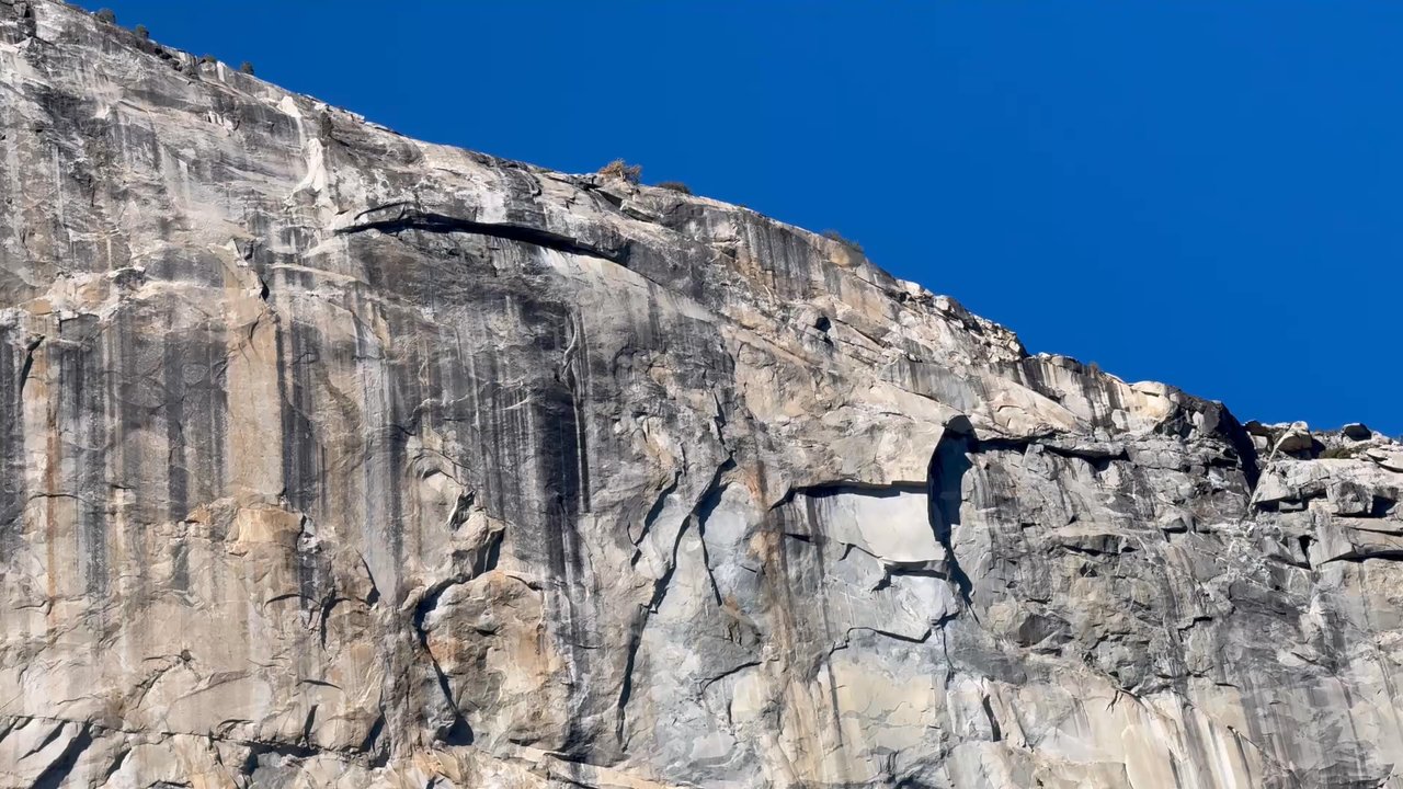
This is one of the most famous rocks in the country. That's somewhat thanks to the film Free Solo, but also thanks to beauty of its facade. It is a towering monument as you enter Yosemite Valley. There is a trail that reaches the base of the rock where you can begin scaling the wall, and there is also a trail to the top if you're willing to hike a very long way to it. It's a beauty no matter what angle you view it from.

Yosemite is an amazing place for everyone. We came on Friday, December 30, 2022 and it was raining, it wasn't too crowded, you could stop and take amazing pictures and walk to the woods but not el capitan or a few other places were closed to hike because of weather, regardless it was a great famiky

This granite gem is so huge that stopping anywhere along the side road will give you that awe satisfaction. I didn't personally climb this rock (it looks strenuous and scary) but sure did admire it from the bottom. Some do say that the best view would be from Bridalveil Straight because you can spot a heart shape granite on El Capitan. A must see and a sight that won't be missed. PS: Remember, that an advance booking reservation is required to visit this park due to COVID.


So you can't go to the Yosemite Valley without stopping at El Capitan. The awe inspiring granite monolith is a sight to be seen. I'm not a climber by any stretch of the imagination, I get dizzy climbing stairs so this monster is out of bounds for me, but gazing upon its massive face was not only breathtaking it was downright awesome! It takes a minute or so for your eyes to adjust so you can locate the climbers, if you have a telescope it's much easier to spot them. On this day a park ranger set up a couple telescopes that focused on climbers in various points in their climb. The statement "no mistakes" was at the forefront of my mind as I witnessed their endeavor. The sheer size of El Cap is appreciated when you compare it to the tiny climbers and their 3-5 day quest to reach the top (unless you're one of the super humans who have climbed it in under 3 hours!) Truly remarkable. But that's not all, there are loads of trails and hiking paths even one that will drop you at the top of El Cap if you're up for a difficult 16-20 mile hike (extra miles if you want stunning pics of the other granite giants like Clouds Rest, North Dome or the famous Half Dome.) Again, not something I'd do, but I absolutely appreciate those who call that trek a hobby. The Merced river, the flora and fauna and the wilderness is all around you so bike rides, picnics, hikes and simply enjoying the great outdoors and of course.....the silence are options. So much to do here, you can easily make an afternoon of it. If you've never been, you must go.

This is a stunning rock structure that you can get some great views of from the side of the road. We stopped at pull offs along the road both on our way into Yosemite Valley and our way out of the valley. You can also get good views from further away at Tunnel View and Sentinel Dome. This is one of the main iconic sites in Yosemite, so you definitely won't miss it and don't have to work hard to see it either.

This iconic rock is worth every mile I had to drive from LA. My rock climbing group said, "It'll be fun . . . " and it was. By far the greatest challenge I have had yet. While I did not climb even half of the face, I did take some amazing photographs We went to Yosemite at the perfect time. Cool breezes, sunny days and snowcapped mountains. We arrived before the summer tourists and crowds. Arriving right before sunrise offered us the most optimum viewing of the sun coming over the mountains as we drove through the tunnel. El Capitan in Yosemite are not only worth the trip, next time I think I'll stay longer.

What simple splendor! I went to Yosemite with a few friends, and one of them works for Apple. She's a little obsessed with El Capitan as a landmark... and I think as an iOS? The first day we were there, the sun was going down, and it was the perfect timing for photos. There's an open prairie on the way to Yosemite where you can stop and take gorgeous pictures of this monolithic rock. Mind you, the prairie CANNOT be found on the way back from Yosemite. We drove around for awhile and concluded that the hard way. I'm not sure if people scale El Capitan, but the idea sounds horrifying. Just looking at it from a distance is good enough for me. It was one of my favorite attractions on my Yosemite visit. Absolutely breathtaking. Photos don't do it justice, so go see it yourself.

One of the iconic scenery in Yosemite Valley. I hiked up here from Yosemite Upper fall trail and El Capitan Trail. Out and back 16 miles, 4000 feet elevation gain. It is possible to see other Yosemite's famous peaks, such as Half Dome and Clouds rest. The top is not as vertical as Taft point, but still nice to stand there.

The Mother Rock Of Yosemite! El Capitain is famous for its monolithic stance that makes Yosemite National park as famous as it is. Rock climbing that brings people from around the country and the world to scale these walls! There is a campground near the climbing area for climbers. It's pretty crowded but the place to be if you are there to climb! This is a must see if you love nature. it's fame is well deserved!


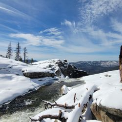
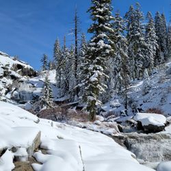
This is a hike review to the top of El Capitan from the Yosemite Valley. December 2, 2017 Left Elk Grove at 3:30 am, arrived at Camp 4 campground 6:15 am. Started hiking at 6:40 am (sunrise), it was 27 degrees outside, but with no wind it was very nice. I took my beanie and gloves off within the first 10 minutes of hiking because my body was heating up and heart a-pounding. Reached the top of Upper Yosemite Falls lookout/overlook at 9 am. We took some photos there as well as on our way up at "Oh my Gosh" and other areas. This is my 3rd hike to the top of Upper Yosemite Falls this year that I didn't take but a handful of photos on the way up, though we did pause to take in the scenery. The only time we were cold was when we were at the falls lookout where it was extremely windy. After the lookout we refilled a water bottle across the bridge going towards North Dome and then hiked back across the bridge to continue the trail towards El Capitan. There was a lot of snow on the trail at this point from a previous light snowstorm that we had to hike through in different spots. Reached the top of El Capitan at 12:15 pm. Had lunch, took some pics and relaxed for about 30 minutes total. It's roughly nearly 8 miles to the top of El Cap, and the elevation keeps your heart motoring even when hiking downhill. Left the summit at 12:40 and hiked backed down and reached our car at Camp 4 at 4:00 pm! The hardest part of this hike in my opinion is the return downhill. It's a long day hike nonetheless, but without trekking poles it can be brutal on the knees. The good news is that once we started walking around on flat ground again in Campground 4 our knees felt much better. It's basically walking downhill for 3+ hours...it gets old and tiring, where your body just wants an uphill climb. I don't recommend doing this hike late in the season due to the low Yosemite Falls runoff, cold temperatures (when your not moving), and sun setting around 5 pm which means you need to be constantly moving. We were pretty much moving all the time as we didn't want to hike back in the dark. My Samsung S7 phone showed 46,283 steps and 19.42 miles hiked and 3032 calories burned! Enjoy my other Yosemite National Park hike reviews!
The view for El Capitan can all be done while driving - no need to hike to this one unless you prefer! If you'd like to park there is a small parking lot where you can park and walk closer to get a picture of this beautiful view. If you take the gps to tunnel view it will take you exactly to the spot of photos I have attached to this review. I'm sure there are opportunities to get closer to El Capitan but this is an easy way to get a view and some pics! read more


1 year ago
Stunning! Even in December. TIP: Wear comfortable ( and sensible) walking shoes and layered clothing. read more

I got straight As in Geology and then was told that Geology was considered the Kim Kardashian of Natural Sciences (in that, she's not really a celebrity). Now don't get your feathers ruffled Geology majors - I'm on your side!! 3,000 feet from base to summit, all gray granite and a formidable foe to all climbers (although I didn't spot anyone climbing that day). When you look at El Cap, it looks totally insurmountable. Which is why what Alex Hannold did - he free solo'd El Cap in a few hours is truly outstanding!! As you may know, free soloists climb alone and without equipment (they wear proper shoes and use chalk for their hands, that's all). Needless to say, there aren't too many free soloists walking around. So when you come here, slow down and just stare at El Capitan. Though not as breath taking as the Grand Canyon, It's a true, majestic Geological wonder. And finally, Geology is a true natural science and Kim is also a true superstar. read more


3 years ago
This is one of the most famous rocks in the country. That's somewhat thanks to the film Free Solo, but also thanks to beauty of its facade. It is a towering monument as you enter Yosemite Valley. There is a trail that reaches the base of the rock where you can begin scaling the wall, and there is also a trail to the top if you're willing to hike a very long way to it. It's a beauty no matter what angle you view it from. read more


Yosemite is an amazing place for everyone. We came on Friday, December 30, 2022 and it was raining, it wasn't too crowded, you could stop and take amazing pictures and walk to the woods but not el capitan or a few other places were closed to hike because of weather, regardless it was a great famiky read more

This granite gem is so huge that stopping anywhere along the side road will give you that awe satisfaction. I didn't personally climb this rock (it looks strenuous and scary) but sure did admire it from the bottom. Some do say that the best view would be from Bridalveil Straight because you can spot a heart shape granite on El Capitan. A must see and a sight that won't be missed. PS: Remember, that an advance booking reservation is required to visit this park due to COVID. read more

Words cannot describe... do it. Park off Northside and hike it right to the mountain. I loved it, it's beautiful and could only dream of climbing it although I did climb/boulder a little. This was my bucket list item, all of Yosemite is beautiful!!! read more


So you can't go to the Yosemite Valley without stopping at El Capitan. The awe inspiring granite monolith is a sight to be seen. I'm not a climber by any stretch of the imagination, I get dizzy climbing stairs so this monster is out of bounds for me, but gazing upon its massive face was not only breathtaking it was downright awesome! It takes a minute or so for your eyes to adjust so you can locate the climbers, if you have a telescope it's much easier to spot them. On this day a park ranger set up a couple telescopes that focused on climbers in various points in their climb. The statement "no mistakes" was at the forefront of my mind as I witnessed their endeavor. The sheer size of El Cap is appreciated when you compare it to the tiny climbers and their 3-5 day quest to reach the top (unless you're one of the super humans who have climbed it in under 3 hours!) Truly remarkable. But that's not all, there are loads of trails and hiking paths even one that will drop you at the top of El Cap if you're up for a difficult 16-20 mile hike (extra miles if you want stunning pics of the other granite giants like Clouds Rest, North Dome or the famous Half Dome.) Again, not something I'd do, but I absolutely appreciate those who call that trek a hobby. The Merced river, the flora and fauna and the wilderness is all around you so bike rides, picnics, hikes and simply enjoying the great outdoors and of course.....the silence are options. So much to do here, you can easily make an afternoon of it. If you've never been, you must go. read more

. - Hiking Near Me")


7 years ago
This is a stunning rock structure that you can get some great views of from the side of the road. We stopped at pull offs along the road both on our way into Yosemite Valley and our way out of the valley. You can also get good views from further away at Tunnel View and Sentinel Dome. This is one of the main iconic sites in Yosemite, so you definitely won't miss it and don't have to work hard to see it either. read more


This iconic rock is worth every mile I had to drive from LA. My rock climbing group said, "It'll be fun . . . " and it was. By far the greatest challenge I have had yet. While I did not climb even half of the face, I did take some amazing photographs We went to Yosemite at the perfect time. Cool breezes, sunny days and snowcapped mountains. We arrived before the summer tourists and crowds. Arriving right before sunrise offered us the most optimum viewing of the sun coming over the mountains as we drove through the tunnel. El Capitan in Yosemite are not only worth the trip, next time I think I'll stay longer. read more


8 years ago
What simple splendor! I went to Yosemite with a few friends, and one of them works for Apple. She's a little obsessed with El Capitan as a landmark... and I think as an iOS? The first day we were there, the sun was going down, and it was the perfect timing for photos. There's an open prairie on the way to Yosemite where you can stop and take gorgeous pictures of this monolithic rock. Mind you, the prairie CANNOT be found on the way back from Yosemite. We drove around for awhile and concluded that the hard way. I'm not sure if people scale El Capitan, but the idea sounds horrifying. Just looking at it from a distance is good enough for me. It was one of my favorite attractions on my Yosemite visit. Absolutely breathtaking. Photos don't do it justice, so go see it yourself. read more

2 years ago
One of the iconic scenery in Yosemite Valley. I hiked up here from Yosemite Upper fall trail and El Capitan Trail. Out and back 16 miles, 4000 feet elevation gain. It is possible to see other Yosemite's famous peaks, such as Half Dome and Clouds rest. The top is not as vertical as Taft point, but still nice to stand there. read more


9 years ago
The Mother Rock Of Yosemite! El Capitain is famous for its monolithic stance that makes Yosemite National park as famous as it is. Rock climbing that brings people from around the country and the world to scale these walls! There is a campground near the climbing area for climbers. It's pretty crowded but the place to be if you are there to climb! This is a must see if you love nature. it's fame is well deserved! read more


3 years ago
7 years ago
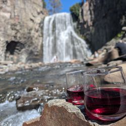
It was breathtaking! The drive was beautiful despite the fire damage. The waterfalls and the raging water was beautiful. Go! read more

Looks like a huge rock but it's so gorgeous in pics lol Its massive and beautiful. Can not explain. Actually got the best shots on the road while driving with the top open. A must see and on the way out of Yosemite for us. Great ending. read more


8 years ago
This is a hike review to the top of El Capitan from the Yosemite Valley. December 2, 2017 Left Elk Grove at 3:30 am, arrived at Camp 4 campground 6:15 am. Started hiking at 6:40 am (sunrise), it was 27 degrees outside, but with no wind it was very nice. I took my beanie and gloves off within the first 10 minutes of hiking because my body was heating up and heart a-pounding. Reached the top of Upper Yosemite Falls lookout/overlook at 9 am. We took some photos there as well as on our way up at "Oh my Gosh" and other areas. This is my 3rd hike to the top of Upper Yosemite Falls this year that I didn't take but a handful of photos on the way up, though we did pause to take in the scenery. The only time we were cold was when we were at the falls lookout where it was extremely windy. After the lookout we refilled a water bottle across the bridge going towards North Dome and then hiked back across the bridge to continue the trail towards El Capitan. There was a lot of snow on the trail at this point from a previous light snowstorm that we had to hike through in different spots. Reached the top of El Capitan at 12:15 pm. Had lunch, took some pics and relaxed for about 30 minutes total. It's roughly nearly 8 miles to the top of El Cap, and the elevation keeps your heart motoring even when hiking downhill. Left the summit at 12:40 and hiked backed down and reached our car at Camp 4 at 4:00 pm! The hardest part of this hike in my opinion is the return downhill. It's a long day hike nonetheless, but without trekking poles it can be brutal on the knees. The good news is that once we started walking around on flat ground again in Campground 4 our knees felt much better. It's basically walking downhill for 3+ hours...it gets old and tiring, where your body just wants an uphill climb. I don't recommend doing this hike late in the season due to the low Yosemite Falls runoff, cold temperatures (when your not moving), and sun setting around 5 pm which means you need to be constantly moving. We were pretty much moving all the time as we didn't want to hike back in the dark. My Samsung S7 phone showed 46,283 steps and 19.42 miles hiked and 3032 calories burned! Enjoy my other Yosemite National Park hike reviews! read more


8 years ago
Simply Breathtaking. The drive up to El Capitan and Yosemite Falls was just as thrilling for me then the actual attractions. read more

Breathtakingly beautiful!!!! So amazing. We got there around 12:30 pm and every single parking lots were full. We drove around and around in circle and finally found a spot. We hiked up to Lower Yosemite Falls. It was so amazingly beautiful. The ground was muddy and wet mixed with snow. Very slippery. The view of the falls is worth it. It's only beginning of April and it was already very crowded. read more


7 years ago
10 years ago
Wow this was one crazy hike. My friends and I stayed at the upper pines camp ground for 5 days and one of the days we decided to do this hike. I thought it would be like any other hike we normally do but was I wrong. It is very difficult. I was definitely not prepared first of all. I had Nike tennis shoes, a water bottle (the rest of the water was with my fiancée), 2 peanut butter sandwiches, granola bars, and some fruit gummies. We started the hike at the bottom up to the top of Yosemite falls. There are two switchbacks on this hike. The first set aren't that bad, but one you pass the middle of the falls that's when it gets difficult. The second set are no joke. I had to take a break after each switch back. It was very hot that morning as well. I am in pretty good shape and it was difficult for me. Once you get to the top of the falls it is beautiful and well worth it. So then my friends and I decided to keep going up to El Capitan. It was one of the longest hikes ever! The scenery to El Capitan was very pretty and mystical. It isn't that bad, it's just long. Once you get to the top the view is wow! I was so exhausted and thinking to go back didn't help either. Going back down is always the worst but going down the switch backs be very careful. It's sandy and the rocks are slippery and steep. Hiking sticks are definitely recommended. Some things I would do differently for this hike is to leave early. We left at about 9:30 am and finished the whole entire 16.4 miles by 8:00 pm. Also, I would invest in som Beijing boots and a camelback. read more


11 years ago
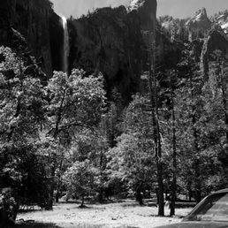
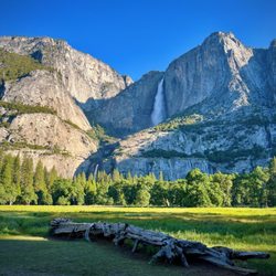
Iconic, epic, a trademark, breathtaking, incredible, and more are words used to describe this world class chunk of granite majestically standing in front of you! When you come in to Yosemite, a rookie mistake is to drive thru the parks and be amazed. My best tip for all first timers and well for everyone, is to stop at every turnout, and get out of the car and look around. Some of the first turn outs after entering the valley give a lovely view of El Capitan, and the short hike to Bridal Veil Falls. The most photographed view of the valley is from Tunnel View, and El Capitan is majestic. Plan a trip so you timing can put you at Tunnel View during a Full Moon, and be there at Moon Rise and well it is a real WOW. At sunset the softer colors is also prime viewing and picture time. Any you you slice it, this is one of the top places on the planet to be. I am in awe and completely humbled on every trip. read more

More info about El Capitan
Yosemite Village, CA 95389
Directions
Visit Website
http://www.nps.gov/yose/index.htm
Hours
Outdoor Amenities
El Capitan Reviews in Other Languages
Ask the Community - El Capitan
Review Highlights - El Capitan


Why does Yelp recommend reviews?
El Capitan - hiking - Updated May 2026
Best of Yosemite Village
People found El Capitan by searching for…
Hiking Trails With Waterfalls in Yosemite Village, California
Rock Climbing in Yosemite Village, California
Star Gazing in Yosemite Village, California
Campgrounds in Yosemite Village, California
Sunset View in Yosemite Village, California
Things to Do in Yosemite Village, California
Picnic Areas in Yosemite Village, California
Free Snow Play in Yosemite Village, California
Stairs Workout in Yosemite Village, California
Stargazing in Yosemite Village, California
Watch Sunset in Yosemite Village, California
Lookout Points in Yosemite Village, California
Sunrise View in Yosemite Village, California
Parks in Yosemite Village, California
Redwood Trees in Yosemite Village, California
Tourist Attractions in Yosemite Village, California
Waterfalls and Swimming Holes in Yosemite Village, California
Stair Climbing in Yosemite Village, California
Hiking Trails Kid Friendly in Yosemite Village, California
Secret Spots in Yosemite Village, California
Points of Interest in Yosemite Village, California
Caves in Yosemite Village, California
Browse Nearby
BEST of Yosemite Village, California Restaurants near El Capitan
BEST of Yosemite Village, California Things to Do near El Capitan
BEST of Yosemite Village, California Coffee near El Capitan
BEST of Yosemite Village, California Breakfast near El Capitan
BEST of Yosemite Village, California Bike Rentals near El Capitan
BEST of Yosemite Village, California Campgrounds near El Capitan