Dennis Hill State Park Photos


You might also consider
More like Dennis Hill State Park
Recommended Reviews - Dennis Hill State Park
Start your review...

7 years ago
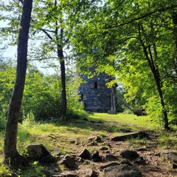
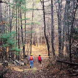
Dennis Hill State Park is a great little park for hiking. We visited here before the road to the top was open, and the whole park was pretty quiet. There's one little loop trail that goes around one of the lower hills, with a gazebo and nice little overlook. After that, we took the side trail up to the top of the hill. There's a really great meadow and picnic shelter up at the top. At the time of our visit, there was a nice stiff wind, so we flew our kite. I bet this place looks really great in the autumn during color season! read more


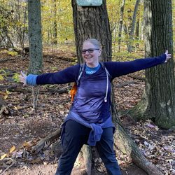
3 years ago
More info about Dennis Hill State Park


Dennis Hill State Park - parks - Updated May 2026
Best of Norfolk
People found Dennis Hill State Park by searching for…
Trending Searches in Norfolk, CT
Botanical Gardens near Dennis Hill State Park
Bounce House Rentals near Dennis Hill State Park
Campgrounds near Dennis Hill State Park
Floral Designers near Dennis Hill State Park
Garden Center near Dennis Hill State Park
Lakes near Dennis Hill State Park
Lakes & Ponds near Dennis Hill State Park
Nurseries & Gardening near Dennis Hill State Park
Off Leash Dog Parks near Dennis Hill State Park
Outdoor Furniture Stores near Dennis Hill State Park
Parks near Dennis Hill State Park
Party Equipment Rentals near Dennis Hill State Park
Pedicure near Dennis Hill State Park
Photo Spots near Dennis Hill State Park
Places To Take Pictures near Dennis Hill State Park
Spray Tanning near Dennis Hill State Park
Swimming Holes near Dennis Hill State Park
Browse Articles
Browse Nearby
Browse Brands
Related Searches in Norfolk, CT
Best Fishing Locations and Guides in Norfolk, Connecticut
Best Nature Trails for Hiking in Norfolk, Connecticut
Best Off Leash Dog Parks in Norfolk, Connecticut
Best Parks for Parties and Events in Norfolk, Connecticut
Best Places for Horseback Riding in Norfolk, Connecticut
Best Spots for Star Gazing in Norfolk, Connecticut
Best Water Parks for Kids in Norfolk, Connecticut
Best Waterfalls and Swimming Holes in Norfolk, Connecticut
Check Out Great Playgrounds in Norfolk, Connecticut
Check Out Off Road Trails in Norfolk, Connecticut
Discover Baseball Fields Around Norfolk, Connecticut
Discover Dog Friendly Trails to Explore in Norfolk, Connecticut
Discover Fun Toddler Parks in Norfolk, Connecticut for Your Little One
Discover Popular Bike Trails in Norfolk, Connecticut
Discover Popular Photo Spots in Norfolk, Connecticut
Discover Scenic Mountain Bike Trails Near Norfolk, Connecticut
Discover Soccer Fields in Norfolk, Connecticut Near You
Discover Top Nature Parks to Visit in Norfolk, Connecticut
Discover a Hiking Trail in Norfolk, Connecticut
Discover the Best Beaches in Norfolk, Connecticut
Discover the Best Night Hike Trails in Norfolk, Connecticut
Discover the Best Running Track in Norfolk, Connecticut
Dog-Friendly Hikes With Dogs in Norfolk, Connecticut
Effective Stairs Workout Spots in Norfolk, Connecticut
Enjoy Camping Adventures Around Norfolk, Connecticut
Enjoy Scenic Night View Experiences in Norfolk, Connecticut
Enjoy the Best Picnic Spots and Ideas in Norfolk, Connecticut
Enjoy the Best Walking Trails in Norfolk, Connecticut
Exciting Cliff Jumping Spots in Norfolk, Connecticut
Explore Beautiful Botanical Gardens in Norfolk, Connecticut
Explore Bike Rentals Throughout Norfolk, Connecticut
Explore Easy Hikes Perfect for All in Norfolk, Connecticut
Explore Free Picnic Areas Around Norfolk, Connecticut
Explore Free Things to Do Around Norfolk, Connecticut
Explore Landmarks & Historical Buildings in Norfolk, Connecticut
Explore Parks With Pull Up Bars in Norfolk, Connecticut
Explore Popular Campgrounds Near Norfolk, Connecticut
Explore Popular Picnic Areas Around Norfolk, Connecticut
Explore Popular Scenic Overlook Points in Norfolk, Connecticut
Explore Popular Scenic Views Near Norfolk, Connecticut
Explore Popular View Points Around Norfolk, Connecticut
Explore Scenic Lakes to Visit in Norfolk, Connecticut
Explore Secret Spots Worth Visiting in Norfolk, Connecticut
Explore Summer Camps for All Ages in Norfolk, Connecticut
Explore Top Dog Parks in Norfolk, Connecticut Near You
Explore Top Gyms in Norfolk, Connecticut Now
Explore the Best Swimming Holes Around Norfolk, Connecticut
Family Friendly Hiking With Kids in Norfolk, Connecticut
People who viewed Dennis Hill State Park also viewed
Campbell Falls State Park
16 reviews
Haystack Mountain State Park
13 reviews
Farmington River Trail
1 review
Noel Baker Trail
1 review
Huckleberry Hill Recreation Area
1 review
Little Pond Boardwalk Trail
2 reviews
Mohawk State Forest
12 reviews
US Horse Welfare and Rescue
6 reviews
Canton Boat Launch
2 reviews
Owen-Mortimer
1 review