Cancel

Open app

Search

Centennial Park Trailhead

5.0 (3 reviews)

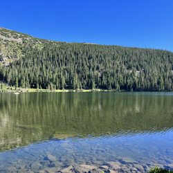
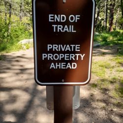
Centennial Park Trailhead Photos

You might also consider

Recommended Reviews - Centennial Park Trailhead

Your trust is our priority, so businesses can't pay to alter or remove their reviews. Learn more about reviews.
Yelp app icon
Browse more easily on the app
Review Feed Illustration

3 years ago

Helpful 36
Thanks 4
Love this 31
Oh no 0

15 years ago

Helpful 3
Thanks 1
Love this 3
Oh no 0

10 years ago

Helpful 6
Thanks 1
Love this 5
Oh no 0

You might also consider

Verify this business for free

People searched for Hiking 622 times last month within 15 miles of this business.

Verify this business

Lion's Lair Trail - Views at the end of spring.june 14, 2016

Lion's Lair Trail

4.4(5 reviews)
3.0 km

Great trail. Nice views. A little over 4 miles with a manageable, gradual incline. I'd say it's…read moremoderate but not particularly challenging. Saw a lot of people running. The trail is well-maintained and marked. The trailhead sign isn't readily apparent from the road so we had to pull over and check that it was the right one. The GPS did have the trailhead as slightly further down the road but we ended up in the right place. There's parking along the road, FYI. The trail will take you to the top of Mount Sanitas. Take a look at the map I posted -- there are multiple trails that take you to the peak.

Beautiful hiking trail just outside of Boulder. I freaking love this trail. I was in Denver and…read moreBoulder for a conference & to see friends. This was one of the short hikes I was hoping to squeeze into my busy day so that I could get that amazing mountain view that I don't get to see in the city. The trail itself is not too steep, and offers beautiful views all around, no matter where you are on the trail. When you are navigating to the trail, you will be driving uphill, and lose cell signal as you approach the base. There isn't really any signal on the trail in general. Parking is all roadside parking at the curved bend of a road. There are clearly areas to park for hikers. This trail when I was hiking was populated by locals either hiking solo or in a small group. Would definitely recommend for a couple hour hike. Only took me about 2 hours.

Photos
Lion's Lair Trail
Lion's Lair Trail - View from Lion's Lair!

View from Lion's Lair!

Lion's Lair Trail - Front the top of Sanitas we decided to take the Lion's Lair trail and it was nice and flat. Easy way down, but definitely a longer way down.

See all

Front the top of Sanitas we decided to take the Lion's Lair trail and it was nice and flat. Easy way down, but definitely a longer way down.

Settlers Park - Junction of longer trails

Settlers Park

5.0(3 reviews)
5.8 km

Now named "The People's Crossing" to emphasize the variety of founders, both indigenous and…read moreEuropean, this is a fine park situated across Boulder Creek from Eben G Fine. You can also connect to many trails north, west, and south! A true crossing of people. With massive Red Rocks and lots of nature, you can do a great amount of exploring here. There's two lots for parking, one off Canyon, or you park on Arapahoe and walk over. Most folks enjoy doing the rocky scrambles near the beautiful sandstone outcrops. They are similar to Garden of the Gods or Red Rocks Amphitheater! Several trails wind around the rocks allowing for plenty of views. You can even find an old foundation on a cliff! If you want to make an adventure out of it, try heading up Anemone Loop for a beautiful forest jaunt! It took me around 2 hours at a moderate pace with plenty of options for exploring.

This is an easy yet nerve-wracking hike. Sections of the trail are slick, so the entire time you…read moreare climbing up you're kinda concerned "how am I gonna get back down??" As it turns out, when you reach the top, there are other trails you can take down. The one closer to the creek is notably less slick and less steep. I unfortunately do not remember the name. Once you get to the top though, wow! Gorgeous views of Boulder and the surrounding foothills. Climbing on the rocks at the top is pretty fun too. Overall this was probably the most "scary" hike I did while in Boulder (but not the most demanding) because it is less maintained than the Eldorado Canyon State Park and the Rocky Mountain trails that I did. But it is still pretty easy, just a bit slippery. Use hiking sticks and you should be fine. I think this is a must do when in Boulder.

Photos
Settlers Park - Nice trails for exercise!

Nice trails for exercise!

Settlers Park - The keeper of Silver Lake ditch!

The keeper of Silver Lake ditch!

Settlers Park - Red rocks trail

See all

Red rocks trail

Crater Lakes

Crater Lakes

4.6(8 reviews)
19.7 km

This is a great trail in summer & winter. Minimum is 7 miles with 1800 ft elevation, slightly…read morelonger to explore around any of the lakes more than the shortest trail provides. It's easy to reach in all seasons: due to the train tunnel, the dirt road to the trailhead is kept well maintained and plowed. Definitely way way more crowded on summer weekends than in winter. Several little waterfalls and tons on wildflowers even in late August made it a rewarding trail along the way, not only payoffs at the lakes. The trail from the lower two lakes to the upper lake is much steeper, but worth the added effort. Just note that when you first reach what you think is the upper lake, it's actually the drainage (albeit also lovely, see my attached photo); you need to go just a bit further over the boulders & through some bushes to reach the final upper cirque.

James Peak Wilderness area is one of my favs close to Denver. That and Indian peaks wilderness…read more Crater lakes is a moderate hike to 5 fantastic lakes that you can hike, camp, backpack, fish at. Last time I was there I saw two amazing Moose...just gorgeous. Area gets insane on the weekends with tons of peoples and dogs. Last three times I have been there I have been in thunder and hails storms after 1 pm. So if you are planning to hike getting off the mountain before might be a good idea. You can also take the more strenuous Heart Lake trail which is also fantastic and if you really want to kick your ass go up to Rogers pass for beautiful vistas. Great parking.

Photos
Crater Lakes
Crater Lakes
Crater Lakes

See all

Forsythe Canyon Trailhead

Forsythe Canyon Trailhead

4.0(1 review)
10.7 km

Seeking to spend a day out in nature and catch-up, Kristin M and I chose to make our way up…read moreNederland ways and check out Forsythe Canyon. Here are a few tidbits to ensure that you have a "fan experience" during your visit to Forsythe Canyon: ++ While they do offer parking at the trailhead, it is a bit of a mess. Since it is near Boulder (and all trailheads in Boulder fill up quick) I highly recommend arriving early to ensure you don't have to wait to park. Also a high clearance vehicle isn't really necessary, but be careful of the rocky areas that may cause your vehicle bottom out. ++ The trail its self is well marked for the most part making it easy to just enjoy your day in nature. Bonus is that it follows a small stream most of the way to Gross Reservoir making it quite cool on a warmer summer day. ++ There are several really great photo spots including: various spots along the creek, the rocks above the small waterfall, below in front of the waterfall, and lastly at Gross Reservoir. ++ Bring some snacks for a little picnic by the reservoir. There's some great areas along the banks to recharge and relax before heading back to the car! While I wouldn't say that Forsythe Canyon is an absolute must see; it was a pretty enough hike that I'd recommend it to anyone looking for the following: a simpler short hike, not to far from the Denver/Boulder area, water and lots of foliage! It easily checked those boxes for me! **Pro Tip(s): Do not park along the road leading to the trailhead - unless it is in a designated area. Residents further up the road appear to get very frustrated by the congestion caused by parking on this narrow dirt road. Leashed dogs ARE allowed. So go ahead and bring your furry friend along for the adventure, but please respect the leash requirement.

Photos
Forsythe Canyon Trailhead

See all

Chautauqua Park - More excavators

Chautauqua Park

4.8(348 reviews)
7.7 km

Things are changing here after 100 years. Chautauqua Auditorium is being renovated and winterized…read more It had been needed before this as another concert venue in Boulder would have been appreciated sooner but once Boulder won Sundance it became a necessity. But when you come in the summer it will still look the same. A removable heated tent will be erected inside and heated by geothermal heat from underneath that will be transferred underground from the dining hall kitchen's surplus stored energy. So modern in such an old structure. So when you visit this spring there is a lot of truck traffic and digging and detours around the building but you can see from the last picture, the green and the view of the Flatirons are undisturbed.

I have been bringing my child here since she was old enough to crawl. We love Chautauqua Park. I…read morelove coming here and just running the trails of course very carefully and I've taught my daughter to run the trails of course very carefully. Today was especially fun because we brought her friend Vincent. My daughter has grown up in Colorado hiking skiing doing all the Colorado things and it's just so emotional seeing her finally making it up to the royal arch for the very first time . We've done Sequoia national Park trails and Yosemite trails but royal arch has so many different parts to it hike it is a lot shorter than a lot of national park trails but it's more challenging in. There are a lot of boulders to crawl up and down from and a lot of tight squeeze places to get to the most amazing view you have ever seen. Very worth it please come ! Unfortunately, this hike is not for unexperienced hikers to go alone please bring a friend who has done it before or has hiking experience. I would not recommend taking your very small children up here or elderly that are not athletic. They simply won't enjoy their time again. It's very challenging for a lot of people. Please do not let this discourage young adult adults that are healthy and whole. If you have never hiked before, but are an avid runner you will be able to make it up here. Just make sure you bring a snack and whatever you bring up bring down. Do not leave trash anywhere.

Photos
Chautauqua Park - More wall and door work

More wall and door work

Chautauqua Park - Audience on the Green

Audience on the Green

Chautauqua Park - Sunrise (2/26/23)

See all

Sunrise (2/26/23)

Centennial Park Trailhead - hiking - Updated May 2026

Loading...
Loading...
Loading...