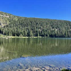
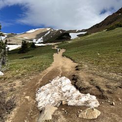
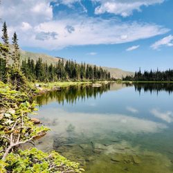
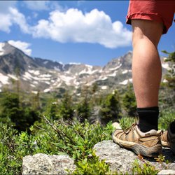
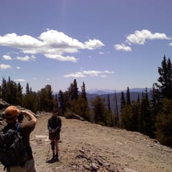
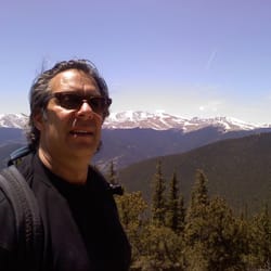
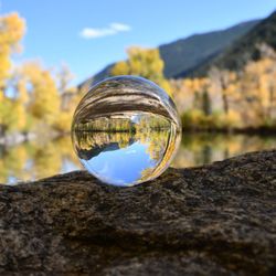
Cancel

    Open app

    Search

    Mount Evans

    5.0 (1 review)

    Mount Evans Photos

    You might also consider

    Recommended Reviews - Mount Evans

    Your trust is our priority, so businesses can't pay to alter or remove their reviews. Learn more about reviews.
    Yelp app icon
    Browse more easily on the app
    Review Feed Illustration

    3 years ago

    Helpful 2
    Thanks 0
    Love this 2
    Oh no 0

    Verify this business for free

    People searched for Hiking 198 times last month within 15 miles of this business.

    Verify this business

    Hell's Hole Trail - Saw this beautiful baby near the picnic tables on the way out.

    Hell's Hole Trail

    (2 reviews)

    This is a great hike not too far outside Denver. I found out about this trail thanks to my "60…read morehikes within 60 miles" book. An aside-- I found that book in Barnes and Noble and impulsively decided to buy it. It's been a fabulous purchase! Some of you CO natives are probably rolling your eyes at me, but I've found a ton of lesser known hikes (as well as some very common ones) thanks to this book-- the most recent of which being Hell's Hole. Hell's Hole trail leads into Mt. Evans Wilderness about 30 min into the hike. About 20 minutes prior to this, there's a little stand where you must self register for a wilderness permit. There is no fee for this, it's basically just a way for the park service to keep track of info. The trailhead is off CO-103 on a pretty obscure road, West Chicago Creek. It gets pretty sketchy towards the end (very narrow road winding up a steep mountain with no guardrails...as long as I live here I'll never understand CO's aversion to guardrails in places like this) but it's well worth it. There's a campground near the trail head as well. The hike itself is a great workout with shade in the beginning and gorgeous views towards the end. Horses and dogs are welcome on the trail; mountain bikes are not permitted. The book I have estimated the total hike time to be 4.5 hours but I was pleasantly surprised to discover it only took me 3 hours, including a 30 min break at the turn around point and a couple photo/water opps. Obviously the hike time will vary for everyone; I guess the important thing to know is that it's 9 miles round trip. Though the hike is relatively long, it's not incredibly difficult. There are definitely some fairly steep portions, but a lot of it is at a relatively gentle incline. It seems like a fairly lightly used trail-- in the whole 3 hours I ran into about 3 other couples. It was really nice to enjoy the solitude, but also somewhat reassuring to know there were people somewhat nearby-- if you're hiking alone, like I was, it's always good to be aware! The trail ends in an open field with a creek nearby. It's around the treeline and you can see a couple fourteeners towering over you in this beautiful post-glacier valley. Definitely an ideal picnic spot! This trail is out-and-back, so once you've had enough of the scenery, it's time to pack it in and do it all over again!

    Absolutely beautiful. Fairly populated trail so I wouldn't feel anxious going here alone. Road up…read morethe the trail head may be a bit difficult to find, just google it, the road is a little sketchy but I made it up in my little Toyota Camry just fine.

    Crater Lakes

    Crater Lakes

    (8 reviews)

    This is a great trail in summer & winter. Minimum is 7 miles with 1800 ft elevation, slightly…read morelonger to explore around any of the lakes more than the shortest trail provides. It's easy to reach in all seasons: due to the train tunnel, the dirt road to the trailhead is kept well maintained and plowed. Definitely way way more crowded on summer weekends than in winter. Several little waterfalls and tons on wildflowers even in late August made it a rewarding trail along the way, not only payoffs at the lakes. The trail from the lower two lakes to the upper lake is much steeper, but worth the added effort. Just note that when you first reach what you think is the upper lake, it's actually the drainage (albeit also lovely, see my attached photo); you need to go just a bit further over the boulders & through some bushes to reach the final upper cirque.

    James Peak Wilderness area is one of my favs close to Denver. That and Indian peaks wilderness…read more Crater lakes is a moderate hike to 5 fantastic lakes that you can hike, camp, backpack, fish at. Last time I was there I saw two amazing Moose...just gorgeous. Area gets insane on the weekends with tons of peoples and dogs. Last three times I have been there I have been in thunder and hails storms after 1 pm. So if you are planning to hike getting off the mountain before might be a good idea. You can also take the more strenuous Heart Lake trail which is also fantastic and if you really want to kick your ass go up to Rogers pass for beautiful vistas. Great parking.

    Diamond Lake Trail

    Diamond Lake Trail

    (9 reviews)

    One of the most beautiful hikes we have ever gone on…read more Wildflowers, streams, waterfalls and an amazing lake to top it off. High elevation and quite tough going up but so worth it!! Took us about 4 hours total. Stop in Nederland on the way down for early dinner or lunch. Fantastic day

    So effing beautiful. Let's just start there. Like the whole way up. Views of trees and mountainous…read moreviews. My legs hurt and I was dehydrated as shit because my moron friends didn't want to stop for food / water beforehand (big mistake). This wasn't the end of the world though due to the natural streams throughout the trek. Just dip your head in for some of the coolest most refreshing water you have ever tasted. Seriously, it beats the hell out of a bottle of Poland Spring or Fiji or whatever your posh ass is used to. I may retract that statement in a week when I have a tadpole making a nest (or whatever tadpoles do) inside of my stomach but for now ... yeah ... refreshing :) Get there early and have a car that you can beat up a little / SUV since there is about 4 miles of hilly dirt roads to get to the trail-head. I recommend hiking boots but I was fine in sneakers. Definitely take snacks / water and if your friends convince you otherwise just poke them hard in the gut with your hiking poles / stick (yes you probably want these too) until they cave in and stop the car for you. The trail is easy to follow. There is a split after about 1 - 1.5 miles up that has you chose between Apache Trail and Diamond Lake. We went for the lake. You will know you are there. If you miss it, congrats, you will probably be some giant grizzly bear's dinner that night. It was one of the more beautiful hiking sites I have bore witness to. For an added bonus and guys if you don't mind your balls retreating up into your stomach for warmth, take off those shoes and climb onto that rock in the center of the lake for some incredible panorama photos. The area surrounding the lake is great for a nap, a picnic, a read, etc. On our way down we stumbled across a man who sprained his ankle about 2 miles in. As a 9 person bachelor party we helped carry him 2 miles to the bottom. Humanitarian mission of Colorado has been complete, sites have been seen, and headache from altitude sickness is quickly on-setting due to lack of nutrients and H20. Despite hunger and a pounding headache, I definitely want to get back to the area and try a few other trails. Such an amazing escape from my normal city life.

    Squaw Mountain

    Squaw Mountain

    (4 reviews)

    Beautiful hike today. Never been here but I have a webcam link to see the summit. So when I saw a…read morecloud inversion, I came as fast as I could! The "trail" is really just a dirt service road, in good shape though. You can drive up a bit more to the gun range, my highlander was ok but really low cars might have issues. The trailhead is a bit loud with the gun range. The .22s are one thing and only moderately freak my dog out. Some folks bring large caliber weapons and those can take away from the scenic value a bit. You can hear them from the fire tower too. The hike is uphill but never very steep. However it's a bit unrelenting, and you can skid on the loose dirt. It's only a long straight way then two switchbacks, and you're there. Not too many views except at the summit cone. The last few hundred yards are well constructed rock steps. Then you're at the fire tower! Views abound in every direction. The tower was occupied but you can still wander the base. There's a lot of communication things, which was funny to me since you have no service the whole hike. It took me around half an hour to climb to the top. There's some fun rock scrambles around as well if you're up for that. Overall, a pretty basic hike with a great payoff! I think it would be awesome for a sunset or sunrise.

    "We have ways of getting you to the summit," said my high school pal with a smile and wink, who…read moreinsisted it was an easy, 2-hr hike up Chief Mountain. Bad News: Chief Mountain was closed on Memorial Day because of too much snow. Good News: We didn't know it until after we thought we'd hiked to the top. "Damn, the trail head must be here somewhere,"....."hmmm, ah...the hell with it. Let's just bushwack this and go straight up." And, we did. My high school pal and two other intrepid Boulder locals revealed to me that it had been 5 years since they'd done this "hike," and they couldn't exactly remember where trail head was located. The consensus of the group: start climbing. OY! It was steep, even traversing. My Chicago wind and stamina didn't fail me, but oh, boy, did I ever feel it. I wasn't gasping but I was ... well.....sucking wind big time. It was beautiful, too. There wasn't a cloud in the sky. There were birds everywhere. I saw a Blackbird, a Cormorant, an Oriole, a handful of crows, doves, ducks, geese, hawks, a grouse, a Great Blue Heron, a hummingbird, a mountain pelican and a woodpecker. We saw jackrabbits, squirrels, deer, scampering pikas, two wily foxes, and we were pretty sure we saw elk in the distance. The skunk: meant to be smelled and not seen. There were running streams and snow drifts. There was a hearty breeze that dried my sweat, which became profuse toward the top as we covered a jagged boulder field on all fours. The Summit: 11,800. Views of the front range, Mt. Evans, Pikes Peak, and the plains. Perfection and supreme exhaustion. We ate p&j sandwiches, and oranges. We took pictures and relaxed. We marveled at how simple, cleansing, and energizing a thrill knocking yourself out can be. We were exhausted. We chose to walk down the fire road we found off the back of the summit. We walked down a bit and saw the sign: "Squaw Mountain, Summit: 11,800." Ha! We weren't even on Chief Mountain and my local pals didn't even know it. If you want to walk up the back fire roads rather than macho out like we did, here's where to find the SQUAW MOUNTAIN trail head location: From the intersection of CO-74 (Evergreen Parkway) and CO-103 (Squaw Pass Road), go west for approximately 12 miles. Just after you pass the turnoff to Echo Mountain Ski Area, there is a dirt road on the left side of the main road. Park here or, if the parking area is filled, continue up the hill and park at the intersection with the old Squaw Pass road. You will have to hike back down the old Squaw Pass road to meet the other road. Got that?

    Mount Evans - hiking - Updated May 2026

    Loading...
    Loading...
    Loading...