Centennial Park Photos


More like Centennial Park
Recommended Reviews - Centennial Park
Start your review...

Reviews With Photos
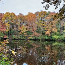
[As of 13 November 2021] Today was another walk in the park. The wife, the dog, and me. There is a handful amount of parking spaces. Just about 20 cars or so. It seems to get a bit busy on the weekends. There is a covered restroom structure but they were locked. You can take your chances with the porta potty. We visited early afternoon and the foot traffic was light. There are few paths to take and are easy to navigate. Due to it being fall/winter, our path was littered with leaves which was cool. Quite a few families use this spot as a venue for picture taking. Enjoy the breeze and nature scene. fin.


1 month ago
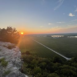
Great Park! So many beautiful trees. It's a great workout with many wonderful trails. My two-year-old daughter loved it and the little cute play area. Go to this park if you have not been there. It's so pretty and well kept. read more


1 month ago
8 months ago
[As of 13 November 2021] Today was another walk in the park. The wife, the dog, and me. There is a handful amount of parking spaces. Just about 20 cars or so. It seems to get a bit busy on the weekends. There is a covered restroom structure but they were locked. You can take your chances with the porta potty. We visited early afternoon and the foot traffic was light. There are few paths to take and are easy to navigate. Due to it being fall/winter, our path was littered with leaves which was cool. Quite a few families use this spot as a venue for picture taking. Enjoy the breeze and nature scene. fin. read more


7 years ago
10 years ago
More info about Centennial Park
300 N. Belt East
Swansea, IL 62226
Directions
Hours
Outdoor Amenities
Ask the Community - Centennial Park


Centennial Park - hiking - Updated May 2026
Best of Swansea
People found Centennial Park by searching for…
Trending Searches in Swansea, IL
Baseball Fields near Centennial Park
Boat Rental near Centennial Park
Botanical Gardens near Centennial Park
Bounce House Rentals near Centennial Park
Campgrounds near Centennial Park
Cheap Plants near Centennial Park
Cherry Picking near Centennial Park
Cliff Jumping near Centennial Park
Flower Fields near Centennial Park
Flower Shop near Centennial Park
Garage Sales near Centennial Park
Garden Center near Centennial Park
Lakes & Ponds near Centennial Park
Nurseries & Gardening near Centennial Park
Outdoor Activities near Centennial Park
Outdoor Basketball Courts near Centennial Park
Outdoor Furniture Stores near Centennial Park
Parks For Parties near Centennial Park
Party Equipment Rentals near Centennial Park
Photo Spots near Centennial Park
Picnic Areas near Centennial Park
Places To Take Pictures near Centennial Park
Places To Take Pictures For Prom near Centennial Park
Playgrounds near Centennial Park
Public Running Track near Centennial Park
Public Shower near Centennial Park
Rock Quarry near Centennial Park
Running Trails near Centennial Park
Rv Rental near Centennial Park
Scenic Drive near Centennial Park
Sunrise View near Centennial Park
Swimming Holes near Centennial Park
Table And Chair Rentals near Centennial Park
Tennis Courts near Centennial Park
Browse Nearby
BEST of Swansea, Illinois Restaurants near Centennial Park
BEST of Swansea, Illinois Things to Do near Centennial Park
BEST of Swansea, Illinois Coffee near Centennial Park
BEST of Swansea, Illinois Walking Trails near Centennial Park
BEST of Swansea, Illinois Parks near Centennial Park
BEST of Swansea, Illinois Day Trips near Centennial Park
BEST of Swansea, Illinois Breakfast near Centennial Park
Browse Brands
Related Searches in Swansea, IL
Best Fishing Locations and Guides in Swansea, Illinois
Best Off Leash Dog Parks in Swansea, Illinois
Best Parks for Parties and Events in Swansea, Illinois
Best Places for Horseback Riding in Swansea, Illinois
Best Water Parks for Kids in Swansea, Illinois
Best Waterfalls and Swimming Holes in Swansea, Illinois
Check Out Great Playgrounds in Swansea, Illinois
Check Out Off Road Trails in Swansea, Illinois
Discover Baseball Fields Around Swansea, Illinois
Discover Dog Friendly Trails to Explore in Swansea, Illinois
Discover Fun Toddler Parks in Swansea, Illinois for Your Little One
Discover Lakes & Ponds to Explore in Swansea, Illinois
Discover Popular Photo Spots in Swansea, Illinois
Discover Scenic Mountain Bike Trails Near Swansea, Illinois
Discover Soccer Fields in Swansea, Illinois Near You
Discover Top Nature Parks to Visit in Swansea, Illinois
Discover a Hiking Trail in Swansea, Illinois
Discover the Best Beaches in Swansea, Illinois
Discover the Best Night Hike Trails in Swansea, Illinois
Effective Stairs Workout Spots in Swansea, Illinois
Enjoy Camping Adventures Around Swansea, Illinois
Enjoy Exciting Mountain Biking Adventures in Swansea, Illinois
Enjoy Tent Camping Spots Around Swansea, Illinois
Enjoy Water Activities and Fun in Swansea, Illinois
Enjoy the Best Picnic Spots and Ideas in Swansea, Illinois
Enjoy the Best Walking Trails in Swansea, Illinois
Explore Beautiful Botanical Gardens in Swansea, Illinois
Explore Beautiful Parks and Green Spaces in Swansea, Illinois
Explore Bike Rentals Throughout Swansea, Illinois
Explore Family-Friendly Zoos and Wildlife in Swansea, Illinois
Explore Free Picnic Areas Around Swansea, Illinois
Explore Fun Activities to Do in Swansea, Illinois
Explore Nature Spots Around Swansea, Illinois
Explore Parks With Pull Up Bars in Swansea, Illinois
Explore Popular Campgrounds Near Swansea, Illinois
Explore Popular Picnic Areas Around Swansea, Illinois
Explore Popular RV Parks Around Swansea, Illinois
Explore Popular Recreation Centers Around Swansea, Illinois
Explore Popular Scenic Overlook Points in Swansea, Illinois
Explore Popular Scenic Views Near Swansea, Illinois
Explore Scenic Lakes to Visit in Swansea, Illinois
Explore Secret Spots Worth Visiting in Swansea, Illinois
Explore Top Dog Parks in Swansea, Illinois Near You
Explore Top Gyms in Swansea, Illinois Now
Explore Top Water Parks in Swansea, Illinois Today
Explore the Best Beach Spots in Swansea, Illinois
Explore the Best Boating Spots in Swansea, Illinois
Explore the Best Swimming Holes Around Swansea, Illinois