Salt Lick Trail Photos


More like Salt Lick Trail
Recommended Reviews - Salt Lick Trail
Start your review...

Reviews With Photos

Wow this is my third time here and it was great. The first two times I went here it was during the morning time. This time I went at night and the view is gorgeous because I was able to catch the sunset. We were there around seven and after the sunset , at least for the last one mile of the hike, it was dark. We had our light sources so it was a great hike. Anyone that like hiking, I recommend this trail because of such nice view.

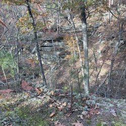
We started at Salt Lick Trail by going counter-clockwise from the trailhead on the right side of the parking lot. Pretty intense incline (built in wooden steps) but better to do the incline at the beginning of your hike than at the end. We stopped a lot on the way up, but others cruised right past us. Keeps steadily going up to Salt Lick Point. Connects to Newman Trail to the overlook. After the overlook, goes back down pretty steeply. Make sure you are wearing boots that fit or your toes will be upset. The last 1.25 miles of the trail (connects to Johnson Trail) is at the bottom of the hill near fields and is flat. Reminded me of Castlewood State Park trail along the river. The flat path is has farmland on one side and bluffs on the other. The bluffs have mines/caves carved from them. Large boulders fallen from the bluffs surrounded the area and ate good for climbing on. It's not possible to get to the mines (and it is prohibited). There are lots of options on routes to take, but this way, we hit all three trails and both overlooks.

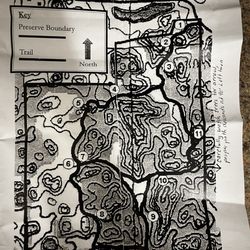
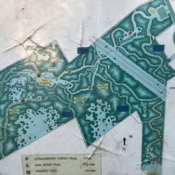
First time here. Was so windy today, got a wildfire alert and we weren't able to see the yellow trail on the way back. We took the red trail first, it starts with steep part. Then there is a shortcut to the look out point if you follow the green trail(see the map I poster in pictures) Moderate trail.

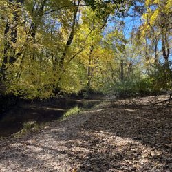
This is a pretty low key trail, I would have never found it but a friend took me here. It's a short but a really fun trail to do if you are up for a little hiking on your day off. It's just right over the bridge on the IL side. The trail is especially beautiful in the fall, definitely give it a try!

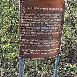
Like a dear old friend this trail never disappoints. And always invites you in with the shear natural and rugged beauty. Amazingly there seem to be 2 or three climates / geographic features from prairies, woods and wetlands. Each with its own intriguing quantity. Great place to spend time with your friends or alone with your thoughts.

This trail is easy to find. Tons of parking. This trail is a good trail for the beginner to the intermediate hiker. Families and dog lovers dot the trail. This is a looping trail. You can start on the less inclined side or just head up the steeper side. Plenty of resting places and photo ops. This trail us very well maintained and clearly marked. This trail is part of the Illinois Ozarks. This trail can be Google for directions.


6 months ago
This is a moderately challenging trail with lookout points and views in otherwise relatively flat farming country. The trail is well-marked once you get on the trail. The most challenging and interesting route is to hike up Salt Lick Trail, take a brief left on Newman Trail, and return to your car via the Johnson Trail. The loop is a lot simpler than it sounds (see my Garmin map pic). This resulted in a 3-mile loop with 551 feet of elevation gain, up to a max elevation of 858 ft near the outlook. There are occasional viewpoints with benches all of the way up, with a flat limestone outlook at the point. There are steep areas (and steps with a cable). I would argue that the woods and limestone bluff are more interesting than the surrounding farmland. On your return via the Johnson trail, look up and left at the bluffs to see caves emerging from the historic salt mine. If you take this route, the abandoned salt mine building will be at the end of the Johnson trail, near the parking lot return. It was moderately advanced, and I recommend good hiking boots. Enjoy! read more


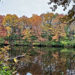
I recently visited with some friends, and we had an amazing time. The trail was extremely muddy, but that's totally our fault for going after it rained a couple days earlier! I guess the mud kept everyone away, because we didn't encounter anyone else for the whole hike. The trail is clearly marked, and there's tons of parking options when you arrive. I noticed a few resting places and even a couple benches throughout the trail. The path we took was pretty flat for awhile until we reached a massively steep incline halfway through. It made us out of breath, but we survived! I'm assuming there's other options you could take to avoid this particular incline. We saw lots of wildlife during our hike, including a snake, turtle, snails, and TONS of frogs. We really had to watch where we stepped because there were both big and small frogs everywhere! The scenic overlook at the top is stunning, and if you look all the way out, you can faintly see some of the tall buildings in downtown St. Louis. I would love to come back in the fall when all the leaves are changing colors. read more


Wow this is my third time here and it was great. The first two times I went here it was during the morning time. This time I went at night and the view is gorgeous because I was able to catch the sunset. We were there around seven and after the sunset , at least for the last one mile of the hike, it was dark. We had our light sources so it was a great hike. Anyone that like hiking, I recommend this trail because of such nice view. read more


We started at Salt Lick Trail by going counter-clockwise from the trailhead on the right side of the parking lot. Pretty intense incline (built in wooden steps) but better to do the incline at the beginning of your hike than at the end. We stopped a lot on the way up, but others cruised right past us. Keeps steadily going up to Salt Lick Point. Connects to Newman Trail to the overlook. After the overlook, goes back down pretty steeply. Make sure you are wearing boots that fit or your toes will be upset. The last 1.25 miles of the trail (connects to Johnson Trail) is at the bottom of the hill near fields and is flat. Reminded me of Castlewood State Park trail along the river. The flat path is has farmland on one side and bluffs on the other. The bluffs have mines/caves carved from them. Large boulders fallen from the bluffs surrounded the area and ate good for climbing on. It's not possible to get to the mines (and it is prohibited). There are lots of options on routes to take, but this way, we hit all three trails and both overlooks. read more


 - Hiking Near Me - Valmeyer, Illinois")


First time here. Was so windy today, got a wildfire alert and we weren't able to see the yellow trail on the way back. We took the red trail first, it starts with steep part. Then there is a shortcut to the look out point if you follow the green trail(see the map I poster in pictures) Moderate trail. read more


This is a pretty low key trail, I would have never found it but a friend took me here. It's a short but a really fun trail to do if you are up for a little hiking on your day off. It's just right over the bridge on the IL side. The trail is especially beautiful in the fall, definitely give it a try! read more

Like a dear old friend this trail never disappoints. And always invites you in with the shear natural and rugged beauty. Amazingly there seem to be 2 or three climates / geographic features from prairies, woods and wetlands. Each with its own intriguing quantity. Great place to spend time with your friends or alone with your thoughts. read more


This trail is easy to find. Tons of parking. This trail is a good trail for the beginner to the intermediate hiker. Families and dog lovers dot the trail. This is a looping trail. You can start on the less inclined side or just head up the steeper side. Plenty of resting places and photo ops. This trail us very well maintained and clearly marked. This trail is part of the Illinois Ozarks. This trail can be Google for directions. read more

5 years ago
The trail was amazing and very peaceful, would recommend this to everyone especially if you want some great view for pictures!! read more


6 years ago
This trail is fun and good exercise if you like to climb up bluffs! I think about 3 miles to complete trails. Did 2 hours hiking read more


7 years ago
10 years ago
8 years ago
8 years ago
More info about Salt Lick Trail
1309 Limestone Ln
Valmeyer, IL 62295
Directions
(618) 935-2131
Call Now
Hours
Outdoor Amenities
Ask the Community - Salt Lick Trail
Review Highlights - Salt Lick Trail


Salt Lick Trail - hiking - Updated July 2026
Best of Valmeyer
People found Salt Lick Trail by searching for…
Things to Do in Valmeyer, Illinois
Places to Take Pictures in Valmeyer, Illinois
Beautiful Views in Valmeyer, Illinois
Hiking Trails in Valmeyer, Illinois
Off Road Trails in Valmeyer, Illinois
Walking Trails in Valmeyer, Illinois
Scenic Views in Valmeyer, Illinois
Photo Spots in Valmeyer, Illinois
Rock Quarry in Valmeyer, Illinois
Lookout Points in Valmeyer, Illinois
Night Hike in Valmeyer, Illinois
Sunset View in Valmeyer, Illinois
Scenic Overlook in Valmeyer, Illinois
Romantic Views in Valmeyer, Illinois
Places to Walk Around in Valmeyer, Illinois
Flower Fields in Valmeyer, Illinois
Stairs Workout in Valmeyer, Illinois
Dog Friendly Things to Do in Valmeyer, Illinois
Fall Foliage in Valmeyer, Illinois
Browse Articles
Browse Brands
Related Searches in Valmeyer, IL
Best Nature Trails for Hiking in Valmeyer, Illinois
Best Spots for Star Gazing in Valmeyer, Illinois
Check Out Off Road Trails in Valmeyer, Illinois
Discover Dog Friendly Trails to Explore in Valmeyer, Illinois
Discover Popular Bike Trails in Valmeyer, Illinois
Discover Popular Photo Spots in Valmeyer, Illinois
Discover Scenic Creeks to Explore in Valmeyer, Illinois
Discover Scenic Mountain Bike Trails Near Valmeyer, Illinois
Discover Stunning Skyline View Spots in Valmeyer, Illinois
Discover Top Nature Parks to Visit in Valmeyer, Illinois
Discover a Hiking Trail in Valmeyer, Illinois
Discover the Best Night Hike Trails in Valmeyer, Illinois
Dog-Friendly Hikes With Dogs in Valmeyer, Illinois
Effective Stairs Workout Spots in Valmeyer, Illinois
Enjoy Scenic Night View Experiences in Valmeyer, Illinois
Enjoy the Best Night View Spots in Valmeyer, Illinois
Enjoy the Best Picnic Spots and Ideas in Valmeyer, Illinois
Enjoy the Best Walking Trails in Valmeyer, Illinois
Experience Stunning Sunset Views in Valmeyer, Illinois
Explore Beautiful Parks and Green Spaces in Valmeyer, Illinois
Explore Easy Hikes Perfect for All in Valmeyer, Illinois
Explore Free Picnic Areas Around Valmeyer, Illinois
Explore Nature Spots Around Valmeyer, Illinois
Explore Parks With Pull Up Bars in Valmeyer, Illinois
Explore Popular RV Parks Around Valmeyer, Illinois
Explore Popular Scenic Overlook Points in Valmeyer, Illinois
Explore Popular View Points Around Valmeyer, Illinois
Explore Secret Spots Worth Visiting in Valmeyer, Illinois
Explore the Best Swimming Holes Around Valmeyer, Illinois
Explore the Best Trail Options in Valmeyer, Illinois
Family Friendly Hiking With Kids in Valmeyer, Illinois
Find Beautiful Views in Valmeyer, Illinois
Find Parks and Recreation Activities in Valmeyer, Illinois
Find the Best Scenic View Locations in Valmeyer, Illinois
Hiking Trails With Waterfalls in Valmeyer, Illinois
Off Leash Dog Hiking Trails in Valmeyer, Illinois
Perfect Spots to Watch Sunset in Valmeyer, Illinois
Plan Nature Center Visits in Valmeyer, Illinois
Plan a Scenic Drive Route Near Valmeyer, Illinois
Popular Things to Do in Valmeyer, Illinois
Safe River Swimming Areas in Valmeyer, Illinois
See Top Fireworks Events in Valmeyer, Illinois
Top Running Trails to Explore in Valmeyer, Illinois
People who viewed Salt Lick Trail also viewed
Homer F Stemler Memorial Walking Trail
5 reviews
Mastodon State Historic Site
44 reviews
Fort Kaskaskia State Park
4 reviews
Strawberry Creek Nature Area
2 reviews
Kress Farm Garden Preserve
3 reviews
Hillsboro City Park
2 reviews
Walther Park
5 reviews
Marsan Canoe & Kayak Tours
14 reviews
Missouri Park Adventures
2 reviews
Silver Creek Nature Preserve
2 reviews