Cancel

    Open app

    Search

    Cardigan State Park

    4.7 (3 reviews)

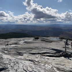
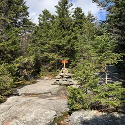
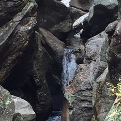
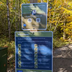
    Cardigan State Park Photos

    You might also consider

    Recommended Reviews - Cardigan State Park

    Your trust is our priority, so businesses can't pay to alter or remove their reviews. Learn more about reviews.
    Yelp app icon
    Browse more easily on the app
    Review Feed Illustration

    3 years ago

    Nice walking trails rewarded by a great view at the top. Parking is confusing and not well maintained

    Helpful 1
    Thanks 0
    Love this 1
    Oh no 0

    18 years ago

    Helpful 3
    Thanks 0
    Love this 4
    Oh no 0
    Photo of Daniel G.
    53
    23
    16

    11 years ago

    Helpful 1
    Thanks 0
    Love this 0
    Oh no 0

    Verify this business for free

    People searched for Hiking 123 times last month within 15 miles of this business.

    Verify this business

    West Ridge Trail - Cardigan Mountain State Park

    West Ridge Trail - Cardigan Mountain State Park

    (1 review)

    This trail to one of the southernmost above-tree line peaks in New England is a dream of a hike…read more For starters, it is a nice length, not too long, not too short. Using the AllTrails app, I logged 2.7 miles out and back. Then, there is the gradient. It seems to be almost a constant gradual gradient from top to bottom, providing for a manageable ascent that can be done by people with very differing physical conditioning. And lastly, the last 300 feet are completely above tree line, providing for some of the most majestic views in New England, from the New Hampshire White Mountains to the north to the entire Green Mountain Range to the west, all the way down to the Berkshires in Massachusetts. Along with spectacular views of the lake Winnepesaukee and Squam Lake to the east. Planning to hike the west ridge trail, one must consider the fact that Mount Cardigan State Park does not require reservations. As a result, this trail can be absolutely packed with people, most of whom comply with COVID-19 guidance, but there are a few Irresponsible individuals who feel that any modicum of concern for the fellow human beings by wearing a mask when social distancing isn't possible, is an obstacle to their happiness. Beware. Another item to consider is proper footwear. Once near the top, the surface is solid, slippery basalt rock. On a wet day, this could mean a disaster for an individual with the improper footwear. Cardigan Mountain is perhaps one of the best places in New Hampshire to admire the foliage season.

    Sculptured Rocks Natural Area

    Sculptured Rocks Natural Area

    (1 review)

    New Hampshire is full of wonderful natural surprises. For a state of small geographic size, it has…read morean immense variety of geography and related attractions. Coastline, beaches, lakes, mountains and rivers. And one of them is Sculptured Rocks Natural Area. This beautiful, out of the way location is a State Park that spans 272 acres, is of glacier origin and was formed by the action the Cockermouth River, which carved a narrow canyon on the granite bedrock on its way to Newfound Lake. The grains of sand suspended in the river current, carved the walls of the canyon throughout the years, creating a multitude of shapes, potholes and other rock formations. The lore has it billed as the "Grand Canyon of New Hampshire which is a stretch. But it is worth visiting. The lower part of the park is the most nature-intensive and features a bridge with amazing views. The upper part of the park is shallows and you can relax, cool off, allow your pup to be in the water and enjoy the scene. Getting here is a beautiful drive through forests and lakeside cabins. Then you go to the parking lot, cross the highway and things get nicer. You can do several nice hikes through the woods and up the river canyon, admiring what nature has carved. Yes, bring your pet but they must be on a leash because a) it's the park regulations and b) your dog can get seriously hurt if he/she wonders off and falls in the ravine. If you like to do yoga or meditation, it is indeed an amazing place early, before the folks show up. The sound of the falling water is about the most soothing sound ever.

    Table Rock Trail

    Table Rock Trail

    (2 reviews)

    Anytime of the year is perfect for the rewarding view. Maybe a little tough during snow and mud…read moreseason, but still doable. Table Rock faces the Bellows Falls are from New Hampshire, just across the Connecticut River. We're in our 60s and needed to stop a few times on the way up, but it was never too steep or treacherous, just a long steady hike. You want bring good hiking shoes with serious treads. No fees. Dogs allowed.

    Phenomenal trail!! Definitely in my top 5 fave hikes - especially for the fall colors (my visit was…read morein early October)!! And it's a killer workout too! The view from the top is breathtaking- but not for the faint of heart - I have a fear of heights and it took me a while to work up the nerve to go sit on the edge lol! AllTrails has this trail labeled as "moderate" - but it was insanely muddy and very wet when I hiked it - took me ages and totally wore me out - so in those conditions I'd call it moderate-hard. And also with the rock scrambling at the top - it can be quite difficult. Very steep and especially narrow at the top - can be dangerous if you're not careful. I did a total of 2 miles round trip - it's an out and back trail. In those 2 miles, my tracker showed an 800 foot elevation gain so it's definitely a butt burner. And along the trail there are numerous areas of rock scrambling (some are very steep) and stream crossings during the wet season - get ready to be covered in mud lol! You will definitely need decent hiking shoes - and poles would've been so helpful I think! There were quite a few other hikers around. The trails are very well marked with colorful tree badges - but in some spots between the markers, I needed my trail map bc the ground was covered in leaves and mud and it wasn't as obvious. Once you get to the top of Table Rock, the stunning view will absolutely take your breath away! It's a sweeping vista of the entire forest area with the lake and resort below to the left and the long stretch of road through the park to the right - perfect for taking in all the colorful autumn splendor!! The top is a long, very narrow and flat tableau. It seems pretty stable - but has extremely steep (and deadly!) drop offs either side and no safety rails or fencing or anything so be aware. Drones aren't allowed in the park (according to the State Park website) but someone was flying one and buzzing us closely at the top which made it very distracting and scary unfortunately. Dogs are allowed - there were many on the trail and at the top. Parking is a small dirt lot pull out on the side of the road at the trailhead - Google maps took me right to it (just put in Table Rock Trailhead). It's located in Dixville Notch State Park (you can see my review of that for more detailed info). The park doesn't have bathrooms that I could find. And I think it's free. I didn't see any fee areas and their website doesn't list it as a fee area.

    Buttermilk Falls

    Buttermilk Falls

    (12 reviews)

    Wow ! What a hidden gem ! We were visiting Ludlow VT and saw this fall . Kids wanted to enjoy…read morewater and this was a perfect choice for us . The water was colddddddddddd though. Ufff . Very cold . The first dip was tough ! Later once you get use of it , it felt a bit better . Pathway was a bit crazy , in some places .it is about a 2 mile walk but we just went not too far : .. the lower and middle falls is also accessible from car parking lots outside . Parking is outside and sometimes you have to park 5-8 mins away from the falls . Not much of restrooms around . Lots of dogs in the water :) It was an amazing tint though ! Loved it . 5 stars !

    As we were staying near Ludlow, I had put this on our schedule as a "check it out whenever time…read morepermits" item. We drove back after visiting some places to the north, and were passing this around 4 p.m. so we checked it out. This was in early October and the sun was just starting to go down. Though it was pre-dusk, it would be better to visit this site in full sunlight. There are 3 separate falls (the creatively named upper, middle, and lower). You access them from the main highway via a side road that starts as paved but soon becomes (good) dirt/gravel. The total length is less than 2 miles. You first get to a wide spot / parking area from which you can access the middle and lower falls. A trail leads down a hill where you must choose which falls to visit. The middle falls is impressive. It is probably the easiest one to access. The area from which you have the best view is a bit rocky, but navigable. It makes for nice photos. The lower falls appeared accessible from a side trail that descended a bit more steeply. You can also see it from above (somewhat) without descending. It appeared smaller and less photogenic than the middle falls. We then drove another 1/4 mile up the road (to its end) to check out the upper falls. There is a sharp short descent from the road to the top of the falls. It appeared to have a fairly large pool at the bottom and a flat dirt/sand area where some people had laid out a blanket for a picnic. The light was fading more so we skipped walking down the relatively gentle slope to check it out further. If you are in the area and have time, this is a nice spot to visit. It is within 3 miles of Ludlow. I cannot comment on what the swimming is like, but I saw references to that online (during summers, I guess).

    Clark Lookout Trail - Tree restoration

    Clark Lookout Trail

    (2 reviews)

    The views at the top of this short walk are amazing. It's a relaxing walk from the trailhead and…read moreonly .8 miles round trip. Great photo opportunities and it's a good place to walk your dog. There is small chestnut tree restoration farm along the way as well as a stone wall that lines the trail. Well worth a visit to see the beautiful vista at the end of this short and easy trail.

    The Kearsarge/Lake Sunapee area is post-card beautiful, and residents and visitors enjoy the active…read morelifestyle and the plethora of things to do. One of the many four-season things available is hiking. And a gem in the hiking category is the Davis Hill and Clark Lookout Trail. The first thing is that almost anyone can negotiate the trail. It is only 0.7 miles long out and back in its totality. But still, visitors should plan an hour. That's because the Clark Lookout Trail provides a spectacular, I mean, write home to mom kind of beautiful, view of Lake Sunapee and Mount Sunapee. A camera or a good quality smartphone is a must, as the views here are amazing. The Clark Lookout property cuts through a neighborhood of million-dollar homes and was made available to the residents through the generosity of Sydney L. Crook and Mary D. Haddad, who donated land and funding to the town of New London for conservation and recreation use. The trail is managed by the New London Conservation Commission. Much of the land and its conservation easements are held by the area's prime land conservation organization, the Ausbon Sargent Land Preservation Trust. For a family traveling on the Interstate that wishes to have a nice break, this spot is optimum. It is also a must for anyone visiting for the first time, as you will fall in love with the area on the spot. The trail is also amazingly dog friendly (on a leash) and poopy bag dispensers are available indifferent places. The Clark Lookout Trail starts on Rt 103-A, across from the Park and Ride lot near Exit 12 on Rte. 89. From that point, the trail climbs only 100 feet. From the Conservation Commission's description, "heading up the trail, the first point of interest is the trail kiosk, which has information about the history of the trail and includes a bulletin board where notices and information are posted. Near it is the libary box, where hikkers can borrow or lend books when they visit. Turn left at the kiosk to continue up the trail. Further on is the four corner road intersection (turn right) which is the last turn before proceeding to the lookout summit". Once on top, a majestic view of Lake Sunapee, Lake Sunapee and the surrounding area greets the visitor. During the Covid-19 pandemic, Clark Lookout is one of these places where you can see the beauty of nature and feel optimistic again.

    Cardigan State Park - hiking - Updated May 2026

    Loading...
    Loading...
    Loading...