Berrypicker Trail Photos


You might also consider
More like Berrypicker Trail
Recommended Reviews - Berrypicker Trail
Start your review...

Reviews With Photos

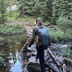
The Berrypicker Trail is a 4.5 mile path that starts at the base of Vail Mountain in Vail Village and then winds its way up to the top via a number of switchbacks. The first half of the trek weaves through thickly wooded patches of aspen trees which are gorgeous with their greenish-gold coin leaves flapping in the wind. You also cross a number of small creeks and blue/white Columbines (Colorado's state flower) are easy to spot along the route. The last half of the trail zig zags you up through grassy open meadows and the scenery is, of course, breathtaking no matter where you look. It took my girlfriend and me 2 1/4 hours to reach the top where the Eagle's Nest complex is located but my fit husband dashed ahead and made it in 1 1/2 hours. From a practical perspective, the Berrypicker Trail is well marked although there are no indications of distance either coming or going which would have been nice. You see the Gondola and get your hopes up that you're near the top but you still have a ways to go. Once you get to Eagle's Nest, there is a restaurant, bar, restrooms, etc... and the best beer you will ever taste in your life. Make sure to go out to the wooden deck which is grand spot for photo ops and has telescopes for viewing the mountain range. Last of all, a very welcome perk is the free Gondola ride down!

This trail name sounds very tranquil but it kicked this 42 year old's butt...maybe because I'm out of shape. We chose to do the uphill hike all the way up to the gondolas which was 3.2 miles. If you choose to do the downhill hike you would need to take the gondola up to the top of the mountain but it costs $35.00 per person. Taking the gondola down is free. The gondolas stop running at 6:00 pm. We were there during off season so you may want to check because some of the business hours and pricing vary depending on the season. If you really want a workout you can go up and down and forget about the gondolas! I was afraid to bring food on the trip to snack on because of the bears. I was told before I started the hike that it would be rare If I saw a bear because it wasn't dawn or dusk and it is a well traveled path. Bears tend to shy away from trails with heavy traffic. I did see two dears galloping across the grass close to where I saw this couple laying down. I'm glad they didn't get run over. If I were to do this over again I would bring something to nibble on because I was getting light headed towards the end of the hike. I would have also brought another water bottle along with the the other two I brought. It would have also helped to have shoes with better tread on them and wet wipes to cool myself off. I found myself slipping a bit when getting up the mountain in certain areas that didn't have rocks or tree trunks that I could stabilize my foot on. Mile marker 1 crosses Strawberry Lane and mile marker 2 crosses Cub's Way . This trail takes about 1.5 to 2 hours. It took me about three because I stopped a lot to take pictures, water breaks, and needed to catch my breath throughout the hike. When you get to the top of the mountain there is a restaurant, zip lining , bungee jumping, restrooms etc. If you still have energy. I thought the gondolas were going to close soon so I opted to get on the gondola because there is no way I could have hiked back down that mountain !

10 months ago


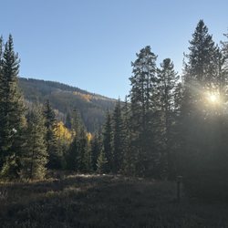
What a beautiful fall trail! Starting from the Lionshead side, this path steeply ascends Vail Mountain till you get up to Eagles Nest, over two thousand vertical feet above, and seven miles round trip. I've skied here a ton and biked once but never tried the hiking trails. And they are pretty awesome! Scenic and rugged, with beautiful large aspen groves and deep spruce woods. Many overlooks and clearing with the ski paths help open up the views! It's not well marked but if you keep going uphill, you'll be ok. Fantastic colors right now(10-7-23). Get out there while you still can! read more


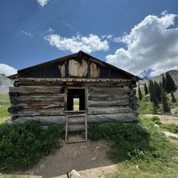
Fairly challenging trail but well worth it. The Berrypicker trail starts and ends just off of W Lionshead Circle - Born Free Lift Express is a good point of reference for mapping purposes - and crosses in and out of a mountain biking trail down the mountain side for about 3.5 miles one way. It is also well marked with signage throughout. The trail is fairly steep at several points with a few spring overpasses and field passes. The majority of the bottom portion of the trail is through the woods with beautiful Burch patches and tree forests with the top portion of the trail more open and with better views. When I say steep, I mean you will definitely feel the burn in your quads, calves, and glutes at times. If you're a beginning hiker, you can do this trail but be prepared to take a lot of breaks and be sure to pack water and snacks. For the more experienced hiker, this trail isn't easy by any means, but is more than doable. Insider recommendation - hike from the bottom up and take the gondola down for free. Gondola rides up require a ticket but are free down. Great views on the way down. Basic food options, beer, water, and bathrooms are available at the top. Overall, great experience. Definitely recommend. read more


The Berrypicker Trail is a 4.5 mile path that starts at the base of Vail Mountain in Vail Village and then winds its way up to the top via a number of switchbacks. The first half of the trek weaves through thickly wooded patches of aspen trees which are gorgeous with their greenish-gold coin leaves flapping in the wind. You also cross a number of small creeks and blue/white Columbines (Colorado's state flower) are easy to spot along the route. The last half of the trail zig zags you up through grassy open meadows and the scenery is, of course, breathtaking no matter where you look. It took my girlfriend and me 2 1/4 hours to reach the top where the Eagle's Nest complex is located but my fit husband dashed ahead and made it in 1 1/2 hours. From a practical perspective, the Berrypicker Trail is well marked although there are no indications of distance either coming or going which would have been nice. You see the Gondola and get your hopes up that you're near the top but you still have a ways to go. Once you get to Eagle's Nest, there is a restaurant, bar, restrooms, etc... and the best beer you will ever taste in your life. Make sure to go out to the wooden deck which is grand spot for photo ops and has telescopes for viewing the mountain range. Last of all, a very welcome perk is the free Gondola ride down! read more


This trail name sounds very tranquil but it kicked this 42 year old's butt...maybe because I'm out of shape. We chose to do the uphill hike all the way up to the gondolas which was 3.2 miles. If you choose to do the downhill hike you would need to take the gondola up to the top of the mountain but it costs $35.00 per person. Taking the gondola down is free. The gondolas stop running at 6:00 pm. We were there during off season so you may want to check because some of the business hours and pricing vary depending on the season. If you really want a workout you can go up and down and forget about the gondolas! I was afraid to bring food on the trip to snack on because of the bears. I was told before I started the hike that it would be rare If I saw a bear because it wasn't dawn or dusk and it is a well traveled path. Bears tend to shy away from trails with heavy traffic. I did see two dears galloping across the grass close to where I saw this couple laying down. I'm glad they didn't get run over. If I were to do this over again I would bring something to nibble on because I was getting light headed towards the end of the hike. I would have also brought another water bottle along with the the other two I brought. It would have also helped to have shoes with better tread on them and wet wipes to cool myself off. I found myself slipping a bit when getting up the mountain in certain areas that didn't have rocks or tree trunks that I could stabilize my foot on. Mile marker 1 crosses Strawberry Lane and mile marker 2 crosses Cub's Way . This trail takes about 1.5 to 2 hours. It took me about three because I stopped a lot to take pictures, water breaks, and needed to catch my breath throughout the hike. When you get to the top of the mountain there is a restaurant, zip lining , bungee jumping, restrooms etc. If you still have energy. I thought the gondolas were going to close soon so I opted to get on the gondola because there is no way I could have hiked back down that mountain ! read more


8 years ago
8 years ago
10 years ago
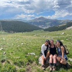
This was a great family hike. My 7 and 5 year old daughters were troopers, had I known it would be so challenging we probably wouldn't have done it! Glad we did now that it's done though. It took us about 3 hours and it was pretty steep throughout. read more


12 years ago
16 years ago
More info about Berrypicker Trail
Vail, CO 81657
Directions
Hours
Outdoor Amenities
Ask the Community - Berrypicker Trail
Review Highlights - Berrypicker Trail


Why does Yelp recommend reviews?
2 reviews that are not currently recommended
The reviews below are not factored into the business's overall star rating.
12 years ago
12 years ago
Berrypicker Trail - hiking - Updated June 2026
Best of Vail
People found Berrypicker Trail by searching for…
Things to Do in Vail, Colorado
Scenic Overlook in Vail, Colorado
Hiking Trails in Vail, Colorado
Sunrise View in Vail, Colorado
Places to Take Pictures in Vail, Colorado
Running Trails in Vail, Colorado
Scenic Views in Vail, Colorado
Hiking With Kids in Vail, Colorado
Off Road Trails in Vail, Colorado
Flower Fields in Vail, Colorado
Things to Do on a Rainy Day in Vail, Colorado
Walking Trails in Vail, Colorado
Waterfall Hike in Vail, Colorado
Hiking Trails Kid Friendly in Vail, Colorado
Mountain Biking in Vail, Colorado
Bird Watching in Vail, Colorado
Trending Searches in Vail, CO
Amusement Parks near Berrypicker Trail
Beaches near Berrypicker Trail
Boat Rental near Berrypicker Trail
Cliff Jumping near Berrypicker Trail
Day Trips near Berrypicker Trail
Dog Friendly Trails near Berrypicker Trail
Fishing Spots near Berrypicker Trail
Jet Ski Rental near Berrypicker Trail
Kayak Rental near Berrypicker Trail
Outdoor Activities near Berrypicker Trail
Pick Your Own Farms near Berrypicker Trail
Public Pools near Berrypicker Trail
Public Shower near Berrypicker Trail
River Swimming near Berrypicker Trail
Running Trails near Berrypicker Trail
Scenic Drive near Berrypicker Trail
Secluded Spots near Berrypicker Trail
Splash Pad near Berrypicker Trail
Sunrise View near Berrypicker Trail
Swimming Holes near Berrypicker Trail
Swimming Lakes near Berrypicker Trail
Swimming Pools near Berrypicker Trail
Watch Sunset near Berrypicker Trail
Browse Articles
Browse Nearby
BEST of Vail, Colorado Coffee near Berrypicker Trail
BEST of Vail, Colorado Restaurants near Berrypicker Trail
BEST of Vail, Colorado Things to Do near Berrypicker Trail
BEST of Vail, Colorado Breakfast near Berrypicker Trail
BEST of Vail, Colorado Parks near Berrypicker Trail
BEST of Vail, Colorado Playgrounds near Berrypicker Trail
BEST of Vail, Colorado Hot Springs near Berrypicker Trail
Browse Brands
Related Searches in Vail, CO
Affordable Kayak Rental Services in Vail, Colorado
Best Fishing Locations and Guides in Vail, Colorado
Best Places for Horseback Riding in Vail, Colorado
Best Sledding Spots and Fun in Vail, Colorado
Check Out Off Road Trails in Vail, Colorado
Discover Dog Friendly Trails to Explore in Vail, Colorado
Discover Kid Friendly Hiking Trails in Vail, Colorado
Discover Top Boat Tours in Vail, Colorado for All Ages
Discover a Hiking Trail in Vail, Colorado
Discover the Best Night Hike Trails in Vail, Colorado
Dog-Friendly Hikes With Dogs in Vail, Colorado
Enjoy Camping Adventures Around Vail, Colorado
Enjoy Exciting Mountain Biking Adventures in Vail, Colorado
Enjoy Kayaking Adventures in Vail, Colorado
Enjoy River Tubing Adventures in Vail, Colorado
Enjoy Tent Camping Spots Around Vail, Colorado
Enjoy a Beautiful Waterfall Hike in Vail, Colorado
Enjoy the Best Family Activities in Vail, Colorado
Enjoy the Best Tubing Experiences in Vail, Colorado
Enjoy the Best Walking Trails in Vail, Colorado
Experience Thrilling White Water Rafting in Vail, Colorado
Explore Beautiful Parks and Green Spaces in Vail, Colorado
Explore Bike Rentals Throughout Vail, Colorado
Explore Easy Hikes Perfect for All in Vail, Colorado
Explore Fun Activities to Do in Vail, Colorado
Explore Popular Campgrounds Near Vail, Colorado
Explore Secret Spots Worth Visiting in Vail, Colorado
Explore the Best Boating Spots in Vail, Colorado
Family Friendly Hiking With Kids in Vail, Colorado
Find Fun Kids Activities Outdoor in Vail, Colorado
Find Popular Ziplining Spots Around Vail, Colorado
Find Top-Rated Disc Golf in Vail, Colorado
Find the Best Playgrounds to Visit in Vail, Colorado
Find the Best Scenic View Locations in Vail, Colorado
Hiking Trails With Waterfalls in Vail, Colorado
Off Leash Dog Hiking Trails in Vail, Colorado
Plan a Scenic Drive Route Near Vail, Colorado
Popular Outdoor Activities to Try in Vail, Colorado
Popular Picnic Spots to Visit in Vail, Colorado
Popular Things to Do in Vail, Colorado
Popular Things to See in Vail, Colorado
Safe River Swimming Areas in Vail, Colorado
Top Climbing Spots and Gyms in Vail, Colorado
Top Paddleboarding Activities in Vail, Colorado
Top Playgrounds for Kids to Enjoy in Vail, Colorado
Top Running Trails to Explore in Vail, Colorado
Top Swimming Lakes to Enjoy in Vail, Colorado
Top Swimming Spots and Pools in Vail, Colorado