Ben Utter Trail Photos


You might also consider
More like Ben Utter Trail
Recommended Reviews - Ben Utter Trail
Start your review...

Reviews With Photos

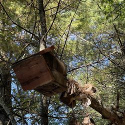
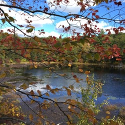
Rocks history and waterfalls The Ben Utter Trail was name after one of the patron saints of Rhode Island conservation and hiking. It's not a long trail, you can do the entire section in two or so hours but it is connected to other trails so you can go hiking in here all day if you desire. The trails are well marked so you probably won't get too lost. The main attraction of the trail is Stepstone Falls, actually a series of small water falls. The water level and the flow of the falls is very depended on the time of year and the weather but you can usually hear running water on the entire hike. A very pleasant and relaxing sound. If you look at the stones around the falls you will notice that most of it is scrapped clean of debris and is very smooth. That's from the action of the water over the years. This usually mellow brook can turn into a raging lunatic during periods of heavy rainfall' On the side on the falls is a huge jumble of massive granite blocks. laboriously moved to this location by people decades or perhaps centuries ago. It looks like some gigantic hand just picked them up and then dropped them. I have yet to determine exactly what this place was but I I suspect their present condition was due to some devastating flood. Perhaps one of the cataclysmic ones due to the hurricanes of the 1950's Large boulders, souvenirs of the the glaciers and many interesting and elaborate stone foundations, left over from mills and homes are scattered around. These now peaceful woods were once a working village filled with people, animals and legerity. There is even an old picnic area, now virtually forgotten. I would love to be able to go back in time and see what this area looked like several hundred years ago. This is one of my favorite hikes. A fascinating place to see massive boulders, cool waterfalls and the impermanence of man's works. A place to ruminate about history and nature. Ben Utter would be very please with his trail.

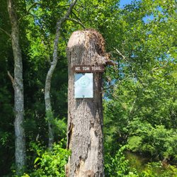
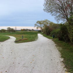
I won't harp on how difficult this trail was to find, everyone else has pretty much covered that aspect. I will say however, that by reading the previous reviews I felt much more lost than I actually was. Without the reviews I don't think I would have found this place on my own (thanks guys)! And being a little more hidden also meant that it was peaceful, quiet, and clean! By following the directions (and landmarks) given by Chris D., we were able to navigate in fairly well. The only thing that I would add to the directions is this: once you pass the red house/barn as you turn into the park, stay to the left ( it's marked "Austin" something road). You'll follow that dirt road for several miles before you come to the bridge where you'll park. Before you get to the bridge you'll pass several other marked trails and a tiny bridge... Keep going, the bridge you want has a "5 ton weight limit"sign and a cute little fishing area. The trail starts just before the bridge, on the left as you approach. Once we got on the trail, it was beautiful and quiet. We saw a handful of other people at one point or another, but for the most part it felt very private and remote. The trail itself was very well marked and easy to follow. There wasn't much of an incline for most of the hike, so beginners and kids will likely find this a fun trail to start out with. The only caution I would give is that although it's a fairly flat hike, the trail is a little tough to navigate unless you really watch where you're going - LOTS of slippery spots, moss covered rocks, tree roots and uneven walking... Not difficult, as long as you keep an eye on the trail and wear a good shoe. (Flip flops not recommended!) We could hear the water throughout most of the hike and arrived at the falls after about an hour of hiking at a leisurely pace (or rather, the pace of a 4 year old)! The falls were lovely and there were a few people there climbing through them and lots of great photo ops for a nice memory to take home. We stuck to the marked trail, but if we'd had more time there were tons and tons of other side trails and other marked trails left unexplored... which gives me a great reason to make another trip back soon! Be sure to bring bug spray, good hiking shoes, plenty of water, and maybe a camera.

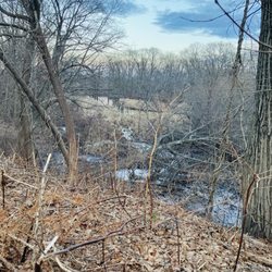
I absolutely loved walking out here. I will say I went while there was a half foot of snow on the ground and that I had a wonderful time despite that bit of obstacle. My favorite thing about this main path was that there was a lot of downhill and there was no confusing where the main path was. If you were looking for a certain trail or path it would be hard to locate, some trails were marked, some trails were not. To my knowledge I do not believe there was a map posted anywhere. You can easily find a map online of this area but the map was confusing so I dunno how far you can trust it. From the parking area with the little half circle drive and the shack in the center, I parked and walked mostly on the big path until I got to a river and The Ben Utter trail that was clearly marked and obviously went along the river on the left side (I assume this was also the trailhead for Stepstone Falls, which I had come specifically to see). I had read reviews on here that said the trail was closer than it was. Even without snow the trail would not be that close. I do wonder if there's some opposite parking lot or something where you can get to the Ben Utter Trail faster. I wouldn't be surprised if there was. I didn't go far over the bridge past the river. By then I was just curious and too exhausted since I'd already done the loop and the darkness was coming. Veering off at random places could really take you for a long confusing detour so be careful out there, there are a lot of trails. The main path I was on? I'm still not sure if this path was supposed to be called something or not. It seemed The Ben Utter Trail was a small sized trail that went along the beautiful fast gushing river and then came right back to the bridge where you started the trail. I highly recommend walking until you get to the river and doing the small trail to the left. It was really pretty and the river was fast so very fun to see. I'd specifically come out here because it was said to be one of the filming locations for Moonrise Kingdom. I will say, on occasion, I did veer off the main road to take little side trails but I really wanted to get to the right trail so I didn't linger much. One of the first side trails lead me to a historic cemetery which looked pretty cool in the snow. It was very close off the main road and definitely worth a small peek. Near the real entrance to The Ben Utter Trail there was a giant river. If you miss the giant river you probably haven't come to it yet. There was a lot of downhill leading to the river so just remember you have to climb all that back up. It wasn't particularly rigorous but it was worth noting. This was not a flat path. All in all I spent at like two hours out here walking around and it was a good moderate workout with some excellent views. I went in February so I assume the river would not be as impressive mid-summer. Just a heads up! I will definitely come back here again.


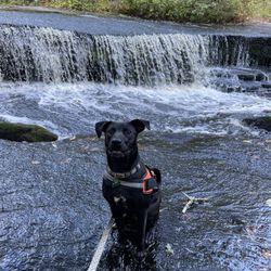
Review from September 3, 2025 For years I've had this place in mind because a friend recommended it, only to find out I had been once before. There isn't too much parking options (about 3, maybe 4 spots), but I also doubt it gets packed. We had our lunch on the rocks by the waterfalls before taking on the Ben Utter trail. One thing I noticed that's new is that there is a rope to swing on over the water. I tried it and it felt pretty secure. We were initially worried we'd get lost but there's essentially only one way there and back. The path does split a couple times into two different avenues but they eventually meet in the same location (I think it has to do with level of difficulty). Definitely bring good shoes with thick soles because the path is pretty rocky. My favorite part of the hike was seeing a black bear! We heard some rustling to our right and thought it might be another hiker, but then we saw that it was a bear walking around in the woods, about 40 feet from where we were. It did not even look our way, so I just stared in awe. The trail is about 1.5 miles together - there and back. We were tired after but we had done a different trail prior, and it was mostly because of the rocky terrain. It is very peaceful, and between the water and plants, there are good views. read more


Two ways to visit Stepstone Falls. One, you can simply park at the falls right off the road. I prefer the second option which is Ben Utter Trail for a quick up and back to enjoy! A short drive down Plain Road you will find the trail head and small parking options. Please note this is rock/dirt road and there was a gate (not sure of hours open/closed). The path follows the waterway for portions of the way up. Chances to view beaver activity and other wildlife along the way as you traverse up to the falls. While it is an easy short hike (approx 3 miles up and back) there are areas with downed trees and a lot of rock within the trail path to note for those that may have weaker ankles or slower movers. Good way to enjoy a quick afternoon in the woods with small falls to relax! read more


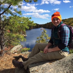
We started at the Stepstone Falls end of the Ben Utter Trail (part of Arcadia Management Area) and what a spectacular view that was! It was after a heavy rainfall and the Wood River was full and burbling. There are a number of trails one can take other than the eponymous one (yellow blazed): right along both sides of the river is the River/North-South trails (blue blazed) and any number of loops can be made. We passed by former camp sites (aging fire pits, outhouses, pavilions), beaver dams, stone walls, foundations, and steps (probably a former mill?). Plenty to see and always with the river sounds in the background. Do use bug spray liberally - even in this early spring walk, the gnats and no-see-ums were plentiful. read more


16 years ago
Rocks history and waterfalls The Ben Utter Trail was name after one of the patron saints of Rhode Island conservation and hiking. It's not a long trail, you can do the entire section in two or so hours but it is connected to other trails so you can go hiking in here all day if you desire. The trails are well marked so you probably won't get too lost. The main attraction of the trail is Stepstone Falls, actually a series of small water falls. The water level and the flow of the falls is very depended on the time of year and the weather but you can usually hear running water on the entire hike. A very pleasant and relaxing sound. If you look at the stones around the falls you will notice that most of it is scrapped clean of debris and is very smooth. That's from the action of the water over the years. This usually mellow brook can turn into a raging lunatic during periods of heavy rainfall' On the side on the falls is a huge jumble of massive granite blocks. laboriously moved to this location by people decades or perhaps centuries ago. It looks like some gigantic hand just picked them up and then dropped them. I have yet to determine exactly what this place was but I I suspect their present condition was due to some devastating flood. Perhaps one of the cataclysmic ones due to the hurricanes of the 1950's Large boulders, souvenirs of the the glaciers and many interesting and elaborate stone foundations, left over from mills and homes are scattered around. These now peaceful woods were once a working village filled with people, animals and legerity. There is even an old picnic area, now virtually forgotten. I would love to be able to go back in time and see what this area looked like several hundred years ago. This is one of my favorite hikes. A fascinating place to see massive boulders, cool waterfalls and the impermanence of man's works. A place to ruminate about history and nature. Ben Utter would be very please with his trail. read more


12 years ago
I won't harp on how difficult this trail was to find, everyone else has pretty much covered that aspect. I will say however, that by reading the previous reviews I felt much more lost than I actually was. Without the reviews I don't think I would have found this place on my own (thanks guys)! And being a little more hidden also meant that it was peaceful, quiet, and clean! By following the directions (and landmarks) given by Chris D., we were able to navigate in fairly well. The only thing that I would add to the directions is this: once you pass the red house/barn as you turn into the park, stay to the left ( it's marked "Austin" something road). You'll follow that dirt road for several miles before you come to the bridge where you'll park. Before you get to the bridge you'll pass several other marked trails and a tiny bridge... Keep going, the bridge you want has a "5 ton weight limit"sign and a cute little fishing area. The trail starts just before the bridge, on the left as you approach. Once we got on the trail, it was beautiful and quiet. We saw a handful of other people at one point or another, but for the most part it felt very private and remote. The trail itself was very well marked and easy to follow. There wasn't much of an incline for most of the hike, so beginners and kids will likely find this a fun trail to start out with. The only caution I would give is that although it's a fairly flat hike, the trail is a little tough to navigate unless you really watch where you're going - LOTS of slippery spots, moss covered rocks, tree roots and uneven walking... Not difficult, as long as you keep an eye on the trail and wear a good shoe. (Flip flops not recommended!) We could hear the water throughout most of the hike and arrived at the falls after about an hour of hiking at a leisurely pace (or rather, the pace of a 4 year old)! The falls were lovely and there were a few people there climbing through them and lots of great photo ops for a nice memory to take home. We stuck to the marked trail, but if we'd had more time there were tons and tons of other side trails and other marked trails left unexplored... which gives me a great reason to make another trip back soon! Be sure to bring bug spray, good hiking shoes, plenty of water, and maybe a camera. read more


5 years ago
6 years ago
8 years ago
9 years ago
I absolutely loved walking out here. I will say I went while there was a half foot of snow on the ground and that I had a wonderful time despite that bit of obstacle. My favorite thing about this main path was that there was a lot of downhill and there was no confusing where the main path was. If you were looking for a certain trail or path it would be hard to locate, some trails were marked, some trails were not. To my knowledge I do not believe there was a map posted anywhere. You can easily find a map online of this area but the map was confusing so I dunno how far you can trust it. From the parking area with the little half circle drive and the shack in the center, I parked and walked mostly on the big path until I got to a river and The Ben Utter trail that was clearly marked and obviously went along the river on the left side (I assume this was also the trailhead for Stepstone Falls, which I had come specifically to see). I had read reviews on here that said the trail was closer than it was. Even without snow the trail would not be that close. I do wonder if there's some opposite parking lot or something where you can get to the Ben Utter Trail faster. I wouldn't be surprised if there was. I didn't go far over the bridge past the river. By then I was just curious and too exhausted since I'd already done the loop and the darkness was coming. Veering off at random places could really take you for a long confusing detour so be careful out there, there are a lot of trails. The main path I was on? I'm still not sure if this path was supposed to be called something or not. It seemed The Ben Utter Trail was a small sized trail that went along the beautiful fast gushing river and then came right back to the bridge where you started the trail. I highly recommend walking until you get to the river and doing the small trail to the left. It was really pretty and the river was fast so very fun to see. I'd specifically come out here because it was said to be one of the filming locations for Moonrise Kingdom. I will say, on occasion, I did veer off the main road to take little side trails but I really wanted to get to the right trail so I didn't linger much. One of the first side trails lead me to a historic cemetery which looked pretty cool in the snow. It was very close off the main road and definitely worth a small peek. Near the real entrance to The Ben Utter Trail there was a giant river. If you miss the giant river you probably haven't come to it yet. There was a lot of downhill leading to the river so just remember you have to climb all that back up. It wasn't particularly rigorous but it was worth noting. This was not a flat path. All in all I spent at like two hours out here walking around and it was a good moderate workout with some excellent views. I went in February so I assume the river would not be as impressive mid-summer. Just a heads up! I will definitely come back here again. read more


Great easy to hike trail, my dog loved it! Wearing hiking boots was great because it does get mucky in areas and lots of rocks. There is directions online as to how to navigate this trail but basically stay on either the blue or yellow markers. You will get to an old paved road, I turned near the top of the hill to get back on the trail. Running water was great to hear and see while hiking. Took an hour and 10min at a slow pace read more


14 years ago
12 years ago
12 years ago
10 years ago
More info about Ben Utter Trail
Exeter, RI 02822
Directions
Hours
Outdoor Amenities
Ask the Community - Ben Utter Trail
Review Highlights - Ben Utter Trail
You might also consider


Why does Yelp recommend reviews?
1 review that is not currently recommended
The reviews below are not factored into the business's overall star rating.
13 years ago
Ben Utter Trail - hiking - Updated July 2026
Best of Exeter
People found Ben Utter Trail by searching for…
Hiking Trails With Waterfalls in Exeter, Rhode Island
Things to Do in Exeter, Rhode Island
Beaches in Exeter, Rhode Island
Waterfall in Exeter, Rhode Island
River Swimming in Exeter, Rhode Island
Scenic Drive in Exeter, Rhode Island
Fishing in Exeter, Rhode Island
Off Road Trails in Exeter, Rhode Island
Rope Swing in Exeter, Rhode Island
Photo Spots in Exeter, Rhode Island
Running Trails in Exeter, Rhode Island
Beach Fire Pits in Exeter, Rhode Island
Hikes With Dogs in Exeter, Rhode Island
Dog Friendly Trails in Exeter, Rhode Island
Playgrounds in Exeter, Rhode Island
Stair Climbing in Exeter, Rhode Island
Walking Trails in Exeter, Rhode Island
Swimming in Exeter, Rhode Island
Swimming Lakes in Exeter, Rhode Island
Secret Spots in Exeter, Rhode Island
Beautiful Views in Exeter, Rhode Island
Browse Nearby
Browse Brands
Browse Articles
People who viewed Ben Utter Trail also viewed
Davis Memorial Wildlife Refuge
3 reviews
Flora Whiteley Preserve
1 review
Francis Carter Memorial Preserve
3 reviews
Yawgoo Pond Trail
3 reviews
Thewlis Woods
1 review
Browning Woods Trail
1 review
Black Point Fishing Area
9 reviews
Warwick City Park
41 reviews
John B. Hudson Trail
2 reviews
Beavertail State Park
91 reviews