Mount Tom Trail Photos


You might also consider
More like Mount Tom Trail
Recommended Reviews - Mount Tom Trail
Start your review...


15 years ago
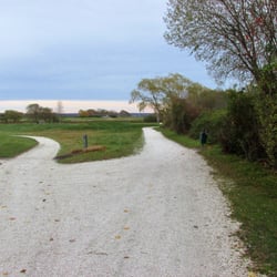
Go take a hike Mount Tom is a well known hiking trail that is part of the Arcadia Wildlife Management Area. Like many of the trails in this part of Rhode Island it is maintained by the Appalachian Mountain Club and is well marked and easy to follow. Even though over 8,000 acres of woods in this area were destroyed by a devastating fire in 1951 the only evidence now of that horrible event are the numerous pines that were replanted over the years. Nature returned with a vengence. The entire trail is only a little over five miles but it crosses many other paths so you can walk all day in Arcadia if you desire. The hiking isn't difficult even though it does ramble up and down for most of it's length. Very few ruts, roots or loose rocks to trip you up and no extremely severe climbs, with a little care you can make good time on this path . Even though there are several nice places for distant views you never really know exactly when you get to the summit. It doesn't really matter because it's not very high, probably only around 500 feet or so and the woods are pretty thick. There are some nice cliffs and ledges and numerous rock formations but nothing dangerous or spooky unless you decide to do something really stupid. There are several parking areas but the most convenient is the Acadia Canoe Launch and Check Station. A huge sign marks the parking lot and there are plenty of parking spaces, nice bathrooms and even a pleasant brook to sit by after the hiking is done. The Mt Tom Trail might not be the highest or longest or most scenic hike in the state but it is one that I always find pleasant, entertaining and interesting. read more


6 years ago
10 years ago
More info about Mount Tom Trail
Ask the Community - Mount Tom Trail
You might also consider


Mount Tom Trail - hiking - Updated July 2026
Best of Exeter
People found Mount Tom Trail by searching for…
Things to Do in Exeter, Rhode Island
Off Road Trails in Exeter, Rhode Island
Hiking Trails in Exeter, Rhode Island
Walking Trails in Exeter, Rhode Island
Hiking With Kids in Exeter, Rhode Island
Running Trails in Exeter, Rhode Island
Scenic Views in Exeter, Rhode Island
Beautiful Views in Exeter, Rhode Island
Dog Friendly Trails in Exeter, Rhode Island
Off Leash Dog Hikes in Exeter, Rhode Island
Easy Hikes in Exeter, Rhode Island
Parks for Kids in Exeter, Rhode Island
Trails in Exeter, Rhode Island
Playgrounds in Exeter, Rhode Island
Waterfalls in Exeter, Rhode Island
Hiking Groups in Exeter, Rhode Island
Must See in Exeter, Rhode Island
View Points in Exeter, Rhode Island
Nature in Exeter, Rhode Island
Hiking Trails Kid Friendly in Exeter, Rhode Island
Watch Sunset in Exeter, Rhode Island
Browse Nearby
Browse Brands
Browse Articles
People who viewed Mount Tom Trail also viewed
Sachuest Point National Wildlife Refuge
65 reviews
Biscuit City Trail
2 reviews
Francis Carter Memorial Preserve
3 reviews
Great Swamp Management Area
2 reviews
Davis Memorial Wildlife Refuge
3 reviews
The Forty Steps
41 reviews
Emilie Ruecker Wildlife Refuge
6 reviews
Cuttyhunk Brook Preserve
1 review
Rocky Point State Park
27 reviews
Neutaconkanut Park
22 reviews
Elmwood