Bee Rock Photos


You might also consider
More like Bee Rock
Recommended Reviews - Bee Rock
Start your review...

Reviews With Photos

GREATER L.A. HIKING ADVENTURE: October 10, 2020 Bee Rock from The Old L.A. Zoo. THE SWEET AND LOW DOWN: This was a short, slightly demanding but, nevertheless enjoyable local "loop hike" that afforded a great view from the summit and also from a few places along the way. MY ASSISTANT: Despite having a having a home library with a strong Local Interest section, I wanted a reliable planning and tracking assistant, so I utilized the app "Map My Hike" to plan this outing in it's entirety -- I have been using various facets of this app for years, especially Map My Ride when cycling. For this adventure I chose the app's maps to plan this hike (from home the night before) because you can zoom in enough to see the various trail names, this can also be done in Google Maps. Then, during the hike, the active GPS mapping shows you where you are and it can also fill the hungriest "data hound" with such things as caloric burn, elapsed time, total distance, and all data (and more) you would expect from today's tech geek friendly activity trackers, like Fitbit. SAFETY NOTE #1: I want to note that at no time did I ever lose connectivity with the internet. Please also note that this will not be the case for all area hikes. For ones where I question connectivity especially longer, more rural hikes, I rely on a satellite-based, pocket sized GPS - with mapping software installed. The ever beautiful and waterfall refreshing "Grotto" hike in mountains near Malibu comes to mind. TRAILS UTILIZED: ASCENT: Bee Rock Trail (a bit demanding due to a good bit of hand and foot scrambling required during the steep vertical ascent portions. If this poses a challenge or at any time you question your own safety or that of those in your party, please return along the route you came up and ascend along the route described in the "DESCENT" notes). DESCENT: Bee Rock Trail, Vista Valle Rd, Bill Eckert Trail and the Lower Old Zoo Trail (except for a VERY short section of single track pathway along the Bee Rock Trail, it is all an easy fire road width route with zero challenges to encounter on what is predominately a simple downhill walk. TOTAL DISTANCE: This hike was roughly 2.5 miles in length. I say roughly because I always forget to turn on my GPS tracking app whenever I go (sorry, I get excited and want to GO! GO! GO! LOL!!)... I was probably 10-15 minutes into the hike and was like, "Oh %$@*! I did it AGAIN!" So, I failed to get the entire hike data but, do know that you can trust me on the 2.5. to 2.75-ish miles total distance. SAFETY NOTE #2: This made me proud of my Angelino neighbors. Everyone on the trails would mask-up prior to approaching and passing UNLESS there was an all too obvious safe distance between your parties. So, at no time did I feel less safe than in a crowded supermarket aisle. DIRECTIONS: The historic Old L.A. Zoo, in Griffith Park, is easy to get to. You will want to navigate to the Merry-Go Round Parking Lot #2. More notes on parking to follow. A quick synopsis has you taking I-5 north to exit 141B Griffith Park Drive. Make a right on Crystal Springs Drive and a left onto Fire Road and follow it to aforementioned parking lot. PARKING: The Old L.A. Zoo has plenty of parking. Three lots specifically granting access to the Merry-Go Round, the playground, the Old L.A. Zoo and access to the area's hiking trails. Trust me, you are 99.9% assured to get a spot (I am a Shakespeare nut so, I will state that, over the years, annual trips here in the evenings to see plays has never brought with it anxiety/fear due to a lack of parking. Best daytime advice? If available... Do yourself a favor and drive to the area between lot #2 and lot #3. There you can park adjacent to the children's playground area actually "on the roadway" and not in the parking lots (just check the curb for the "ever denying" red paint -- that means you can't park in those areas at any time). RESTROOMS: The public restrooms at the playground area were open. These are individual stalls, well stocked with the once pandemically unobtainable toilet paper. Running water and sanitizing soap were also both available, as well as electric hand dryers. GRRR! Yelp cut me off... so I lost paragraphs dedicated to Hydration, suncreen, insect repellent, first aid kits, fueling (yourself) prior to hiking, trail snacks, sunset awareness, being lost, air quality, temperature awareness and more. I am now forced to post an update later. For a more complete review of this and many more adventures please request my Facebook.

Hi everyone! It's tough finding this spot but with the help of another hiker I was able find it. Unfortunately it is closed off due to A Falcon Nesting Area and therefore I didn't go on the actual trail to the end. I stopped where the road meets the trail. I did see some people go through and haven't seen them come out so I guess it's one of those things you do at your own risk. It says it's closed off from February 1st to June 30th. I would respect the habitat and the warnings because you know, it's just the right thing to do. So I hope you do the same. I do plan to come out here again in July to fully check out the spot. The hike up was fun though and worth it in the afternoon. :)

I came here on Labor Day at 9:30AM, and it was a nice way to break into the world of hiking. While there is some trash left around, and some graffiti, the hike to the big, ginormous rock that was 'Bee Rock' was actually satisfying. It was a steep climb, and I fell a bunch, but next time I will just have to be careful, LOL. Recommended hike, but I have to say that this was more like 'rock climbing' than an actual hike.

Despite being given the wrong directions by a bunch of other hikers, this hike is moderate and I'd say it isn't difficult at all. It isn't for the faint hearted, though. From the parking lot, you make your way past a few gates and a slight right up the mountain. You continue for about 2 miles or less, and voila! You have arrived. This hike is fenced around all the way, and you can guess why. It's high up, on a ledge, and very windy in sight. Yet, other hikers have bent the fence to make a hole in it for others to go to the other side. I recommend you not do thag, but it's a nice view. I recommend this hike for those who want a quick getaway. Connected to this hike is the abandoned Los Angeles Zoo, which comes before this hike. You should check that one out first!

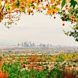
I'm not a pro or avid hiker, i've only hiked a few times, but I think Bee Rock is a nice hike up the concrete jungle of LA! Situated up Griffith Park starting down by the merry-go-round/Shane's Inspiration jungle gym, the hike up and down from the base to the top of Bee Rock round trip is about 5 miles. I would say the trails are intermediate and easy and steep on some parts. You can make it up with running shoes. Once you get up to the top at the rock, you'll be able to walk out to the edge of the rock and enjoy the views of Griffith Park, Glendale and the San Gabriel Mountains. Bring water and a snack, there's a trash can up by Bee Rock as well. Good easy hike.

The hike may be extended 2 miles trails around the old Griffith Park Zoo. It took us another 90 mins and was a wonderful hike. The hiking trail wasn't intense but steep, hiking shoes is needed. From the top of the rock, you have a commanding view over the park and the city beyond. The observation area on the top is surrounded by a tall-chain link fence, protecting hikers from falling off the rocks. It's thoughtful to build a fence, but we feel like the view is slightly covered, ; however, we found on the left side of observation area, the view is slightly nicer without the fence. Once you go down from Bee Rock, an interesting addition 1.5-2 miles hike for you to explore the abandon zoo! Even the zoo has been closed for 60+ years, we still can smell animals during the hike. Hikers! Enjoy this unique creepy hike:)

PARKING There are numerous trails that lead to Bee Rock. However, despite that, we parked in the huge lot by the carousal and hopped onto the simplest trail towards Bee Rock. Plenty of spaces in the lot so I don't see it ever becoming an issue there. WHAT TO EXPECT There are no signs to point you to the right direction. So we took the trail that pointed to the general direction of Bee Rock and continued up a moderate incline. The trail then hit some shade with flat ground before we met a steep climb up towards the end. This part was the most challenging part throughout the whole hike but there was a yellow rope and tree branches to grab that aided our ascent up. This definitely feels like an off trail so if you want to avoid this, there should be another trail further down. If I remember correctly, it loops you around and takes you down some stairs before you reach Bee Rock. Up at Bee Rock, there is no shade. You have a nice view of the city and if you're lucky, a nice breeze blowing through. After leaving Bee Rock, we went up some stairs towards the back. Following an off trail that later involves climbing a metal ladder and pulling yourself up some pipes, we reached the top of another mountain. There, we kept going until we saw the Hollywood Sign, Griffith Observatory, and a panoramic view of the LA cities. Depending what trail you decide to take from here, you can definitely find one that leads to one or the other places listed. During our descent down, we took the Mineral Wells trail after passing the water tank. Our entire hike was about six hours (including breaks). Regardless whether you decide to just hike up to Bee Rock and then back down or keep on going, definitely wear sunblock and bring a hat. The sun is relentless and there is very minimum shade. Water is a no brain but sip smartly. No restrooms or fountains to refill as expected.

For our 1st hike here, I have to say I'm impressed. We started our hike by the marry go round and made our way through the old zoo and up the Bill Eckhart trail behind the old zoo. The hike is a good hike. The trail is a mix of incline and mixed with dirt and cement. We used alltrails for a map on how to get to beehive rock. You'll know you're there when you come to water tower and a marker with the #14. It means your close. All together our hike was almost 5.6 miles. We actually missed the rock and had to turn back 1/2 a mile so the hike ended up being a little longer. The views once you get there are stunning. What I love is the trails area dog friendly and they must be leashed. Our pooch enjoyed the walk. I also highly recommend going past the old see. There's an eery feeling yet nostalgic feeling about it. The county actually put up a picnic area around it. We actually came across it through the back way which made it a bit creepy. I would definitely be doing this hike again, especially because someone here meetings exploring the area during the day and now my curiosity is getting the best of me, ha. Bring snacks and plenty water and you'll be fine. Park at the merry go round and get there before the 10 am otherwise it'll be hard to find parking. Also recommend hiking sticks if you have bad knees.
Bee rock. It sort of matches its name but not really. I started my hike at the Vermont Tennis courts (free parking) and made my way up the road until I found the entrance to the left side. Up that path, I hiked towards the right to make it to the vista Valle trail (which is actually a road). If you make a left down the road you'll make your way to Bee Rock. Park rangers will drive by occasionally so do watch out for cars! The trail itself to the rock was not too bad since it was a paved road. I was surprised by the route getting into Bee Rock because the trail began to be more narrow and a little harder to climb if you don't have proper attire. I didn't hike all the way in because there were people standing at the end. Overall, it was a very nice hike, the view was nice, and enjoyed the elevation because it wasn't too bad. There is a route you can take from bee rock to go to the old zoo but it's very narrow and there are lots of rocks, so be careful if you do plan to head down toward the old zoo. Also, there are branches that can hit you in the face and not enough tractions. HIGHLY recommend hiking shoes if you are planning to hike to the old zoo from Bee Rock.

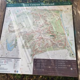
This is one of my new favorite trails at Griffith Park. There are multiple ways to get to Bee Rock. But the one I decided to hike was from Merry-Go-Round parking lot. You can hike a short I think roughly 2 miles round trip on a steep climb up to Bee Rock, or make this a nice 4 mile gradual loop trail and hike down the steep portion instead of climbing up which is more manageable. The Merry-Go-Round parking lot is big, I didn't have problem finding a place to park on a Saturday. The Fern Canyon Trailhead is just across the parking lot. As you hike up you will run into the first posted sign, turn right to the Old Zoo Picnic Area. You can also go left, and jump onto the Upper Old Zoo Trail. Either way you choose will arrive at the same location. Since I wanted to do a loop, I hike up the Old Zoo Picnic Area. It was pretty cool to see the old LA Zoo area. You will see a chain link fence with a door opening, you will go pass it and on the left side you will see posted signs from the Upper Zoo Trail/Bee Rock Trail and Bill Eckert Trailhead. If you want a short but steep climb to Bee Rock, then follow the trail to Bee Rock from here. Otherwise, if you want a nice gradual climb, go onto Bill Eckert trail towards Vista Del Valle Dr. Going up on this trail, you can see Bee Rock on the left hand side. This trail has a lot of posted signs, so it's easy to follow. You will pass about three tanks, once you arrive at Vista Del Valle Dr. You will go left and follow this short paved road to Bee Rock. There will a posted sign and a trash can nearby where the entrance to the fenced in Bee Rock. The view of Bee Rock is pretty cool. It's definitely a good hike and like all Griffith Park trails, you can extend your hike to many other places. So if you want a short hike, this will work, or if you want an all day hike, this will also work as a starting point. Now to finish the loop, when you hike back from Bee Rock, you would of seen a posted sign for Bee Rock Trail. This is the steep terrain with uneven footing. But it's not as bad going down as it is climbing up. It's a short hike back down to the fenced area where you walk thru the chain link fence. To complete the loop, you will go onto the Upper Old Zoo Trail to Fern Canyon Trail. This will take you back to the Merry-Go-Round parking lot. Because there is connecting trails, I suggest printing out a map of the area just in case you want to explore further. https://www.laparks.org/sites/default/files/griffith/pdf/GriffithParkMap.pdf As always pack accordingly to the weather and have fun.

Bee rock is legit a really cool hike! It's steep incline really gives you a workout and makes the short trip to the top of the rock worth it plus the views are phenomenal. Today was clear and beautiful. The other reviews of this place are spot on even the one that said this place is haunted because I really felt some vibes going up and coming back down. Bring water and good hiking shoes!


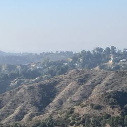
Located in the northeastern corner of Griffith Park, Bee Rock is only accessible by walking. There are many trails that lead to Bee Rock. Some are wide dirt roads. Some are eroding trails. Some are less than that which requires rock scrambling. Because there are so many unmarked trails lacing through Griffith Park, it's easy to get off track. Regardless of the chosen path (intentional or otherwise), they are all short and therefore impossible to get completely lost. The graffiti-tagged pinnacle is fenced to prevent falling off the edge, but there are holes in the fence that allow for unobstructed picture taking or crawling through. The elevation of Bee Rock is rather low so the view is similar to hillside homes or office towers. It's not a peak so the view is 180 degrees instead of 360. The area below the Rock can be undesirable with the homeless and teenagers using the rocks for shelter.

I always wanted to conquer Bee Rock! Especially lately, it was taunting me since I did various hikes in Griffith Park and I would see it from various angles! So I threatened it and I didn't procrastinate. We parked at Mineral Waters Picnic area, you go the start of the hike to Amir's Garden (it is a sign near the parking lot). There are various hikes as you'll see on the map and signs. We kept going passed Amir Garden's and the Vista Del Valle Dr. You will see a sign or a few on the way. At some point (there's a sign) the trails separate - Left to Bee Rock and Right to Hollywood Vista. Once you take a Left, the incline stops. It's less than a mile, a walk in the park, literally, on concrete. Then, you'll see the sign and you'll climb a bit to get on top (there are fences for protection) and graffiti and there you are! On the top of Bee Rock! At least I was! Beautiful hike, not that complicated or long, about 2 miles up and 2 miles back. It's not crowded and you'll see cool staircases and vistas on the way. So I did it! I finally conquered Bee Rock! read more


GREATER L.A. HIKING ADVENTURE: October 10, 2020 Bee Rock from The Old L.A. Zoo. THE SWEET AND LOW DOWN: This was a short, slightly demanding but, nevertheless enjoyable local "loop hike" that afforded a great view from the summit and also from a few places along the way. MY ASSISTANT: Despite having a having a home library with a strong Local Interest section, I wanted a reliable planning and tracking assistant, so I utilized the app "Map My Hike" to plan this outing in it's entirety -- I have been using various facets of this app for years, especially Map My Ride when cycling. For this adventure I chose the app's maps to plan this hike (from home the night before) because you can zoom in enough to see the various trail names, this can also be done in Google Maps. Then, during the hike, the active GPS mapping shows you where you are and it can also fill the hungriest "data hound" with such things as caloric burn, elapsed time, total distance, and all data (and more) you would expect from today's tech geek friendly activity trackers, like Fitbit. SAFETY NOTE #1: I want to note that at no time did I ever lose connectivity with the internet. Please also note that this will not be the case for all area hikes. For ones where I question connectivity especially longer, more rural hikes, I rely on a satellite-based, pocket sized GPS - with mapping software installed. The ever beautiful and waterfall refreshing "Grotto" hike in mountains near Malibu comes to mind. TRAILS UTILIZED: ASCENT: Bee Rock Trail (a bit demanding due to a good bit of hand and foot scrambling required during the steep vertical ascent portions. If this poses a challenge or at any time you question your own safety or that of those in your party, please return along the route you came up and ascend along the route described in the "DESCENT" notes). DESCENT: Bee Rock Trail, Vista Valle Rd, Bill Eckert Trail and the Lower Old Zoo Trail (except for a VERY short section of single track pathway along the Bee Rock Trail, it is all an easy fire road width route with zero challenges to encounter on what is predominately a simple downhill walk. TOTAL DISTANCE: This hike was roughly 2.5 miles in length. I say roughly because I always forget to turn on my GPS tracking app whenever I go (sorry, I get excited and want to GO! GO! GO! LOL!!)... I was probably 10-15 minutes into the hike and was like, "Oh %$@*! I did it AGAIN!" So, I failed to get the entire hike data but, do know that you can trust me on the 2.5. to 2.75-ish miles total distance. SAFETY NOTE #2: This made me proud of my Angelino neighbors. Everyone on the trails would mask-up prior to approaching and passing UNLESS there was an all too obvious safe distance between your parties. So, at no time did I feel less safe than in a crowded supermarket aisle. DIRECTIONS: The historic Old L.A. Zoo, in Griffith Park, is easy to get to. You will want to navigate to the Merry-Go Round Parking Lot #2. More notes on parking to follow. A quick synopsis has you taking I-5 north to exit 141B Griffith Park Drive. Make a right on Crystal Springs Drive and a left onto Fire Road and follow it to aforementioned parking lot. PARKING: The Old L.A. Zoo has plenty of parking. Three lots specifically granting access to the Merry-Go Round, the playground, the Old L.A. Zoo and access to the area's hiking trails. Trust me, you are 99.9% assured to get a spot (I am a Shakespeare nut so, I will state that, over the years, annual trips here in the evenings to see plays has never brought with it anxiety/fear due to a lack of parking. Best daytime advice? If available... Do yourself a favor and drive to the area between lot #2 and lot #3. There you can park adjacent to the children's playground area actually "on the roadway" and not in the parking lots (just check the curb for the "ever denying" red paint -- that means you can't park in those areas at any time). RESTROOMS: The public restrooms at the playground area were open. These are individual stalls, well stocked with the once pandemically unobtainable toilet paper. Running water and sanitizing soap were also both available, as well as electric hand dryers. GRRR! Yelp cut me off... so I lost paragraphs dedicated to Hydration, suncreen, insect repellent, first aid kits, fueling (yourself) prior to hiking, trail snacks, sunset awareness, being lost, air quality, temperature awareness and more. I am now forced to post an update later. For a more complete review of this and many more adventures please request my Facebook. read more


Hi everyone! It's tough finding this spot but with the help of another hiker I was able find it. Unfortunately it is closed off due to A Falcon Nesting Area and therefore I didn't go on the actual trail to the end. I stopped where the road meets the trail. I did see some people go through and haven't seen them come out so I guess it's one of those things you do at your own risk. It says it's closed off from February 1st to June 30th. I would respect the habitat and the warnings because you know, it's just the right thing to do. So I hope you do the same. I do plan to come out here again in July to fully check out the spot. The hike up was fun though and worth it in the afternoon. :) read more


I came here on Labor Day at 9:30AM, and it was a nice way to break into the world of hiking. While there is some trash left around, and some graffiti, the hike to the big, ginormous rock that was 'Bee Rock' was actually satisfying. It was a steep climb, and I fell a bunch, but next time I will just have to be careful, LOL. Recommended hike, but I have to say that this was more like 'rock climbing' than an actual hike. read more

Despite being given the wrong directions by a bunch of other hikers, this hike is moderate and I'd say it isn't difficult at all. It isn't for the faint hearted, though. From the parking lot, you make your way past a few gates and a slight right up the mountain. You continue for about 2 miles or less, and voila! You have arrived. This hike is fenced around all the way, and you can guess why. It's high up, on a ledge, and very windy in sight. Yet, other hikers have bent the fence to make a hole in it for others to go to the other side. I recommend you not do thag, but it's a nice view. I recommend this hike for those who want a quick getaway. Connected to this hike is the abandoned Los Angeles Zoo, which comes before this hike. You should check that one out first! read more

I'm not a pro or avid hiker, i've only hiked a few times, but I think Bee Rock is a nice hike up the concrete jungle of LA! Situated up Griffith Park starting down by the merry-go-round/Shane's Inspiration jungle gym, the hike up and down from the base to the top of Bee Rock round trip is about 5 miles. I would say the trails are intermediate and easy and steep on some parts. You can make it up with running shoes. Once you get up to the top at the rock, you'll be able to walk out to the edge of the rock and enjoy the views of Griffith Park, Glendale and the San Gabriel Mountains. Bring water and a snack, there's a trash can up by Bee Rock as well. Good easy hike. read more


7 years ago
The hike may be extended 2 miles trails around the old Griffith Park Zoo. It took us another 90 mins and was a wonderful hike. The hiking trail wasn't intense but steep, hiking shoes is needed. From the top of the rock, you have a commanding view over the park and the city beyond. The observation area on the top is surrounded by a tall-chain link fence, protecting hikers from falling off the rocks. It's thoughtful to build a fence, but we feel like the view is slightly covered, ; however, we found on the left side of observation area, the view is slightly nicer without the fence. Once you go down from Bee Rock, an interesting addition 1.5-2 miles hike for you to explore the abandon zoo! Even the zoo has been closed for 60+ years, we still can smell animals during the hike. Hikers! Enjoy this unique creepy hike:) read more


PARKING There are numerous trails that lead to Bee Rock. However, despite that, we parked in the huge lot by the carousal and hopped onto the simplest trail towards Bee Rock. Plenty of spaces in the lot so I don't see it ever becoming an issue there. WHAT TO EXPECT There are no signs to point you to the right direction. So we took the trail that pointed to the general direction of Bee Rock and continued up a moderate incline. The trail then hit some shade with flat ground before we met a steep climb up towards the end. This part was the most challenging part throughout the whole hike but there was a yellow rope and tree branches to grab that aided our ascent up. This definitely feels like an off trail so if you want to avoid this, there should be another trail further down. If I remember correctly, it loops you around and takes you down some stairs before you reach Bee Rock. Up at Bee Rock, there is no shade. You have a nice view of the city and if you're lucky, a nice breeze blowing through. After leaving Bee Rock, we went up some stairs towards the back. Following an off trail that later involves climbing a metal ladder and pulling yourself up some pipes, we reached the top of another mountain. There, we kept going until we saw the Hollywood Sign, Griffith Observatory, and a panoramic view of the LA cities. Depending what trail you decide to take from here, you can definitely find one that leads to one or the other places listed. During our descent down, we took the Mineral Wells trail after passing the water tank. Our entire hike was about six hours (including breaks). Regardless whether you decide to just hike up to Bee Rock and then back down or keep on going, definitely wear sunblock and bring a hat. The sun is relentless and there is very minimum shade. Water is a no brain but sip smartly. No restrooms or fountains to refill as expected. read more


For our 1st hike here, I have to say I'm impressed. We started our hike by the marry go round and made our way through the old zoo and up the Bill Eckhart trail behind the old zoo. The hike is a good hike. The trail is a mix of incline and mixed with dirt and cement. We used alltrails for a map on how to get to beehive rock. You'll know you're there when you come to water tower and a marker with the #14. It means your close. All together our hike was almost 5.6 miles. We actually missed the rock and had to turn back 1/2 a mile so the hike ended up being a little longer. The views once you get there are stunning. What I love is the trails area dog friendly and they must be leashed. Our pooch enjoyed the walk. I also highly recommend going past the old see. There's an eery feeling yet nostalgic feeling about it. The county actually put up a picnic area around it. We actually came across it through the back way which made it a bit creepy. I would definitely be doing this hike again, especially because someone here meetings exploring the area during the day and now my curiosity is getting the best of me, ha. Bring snacks and plenty water and you'll be fine. Park at the merry go round and get there before the 10 am otherwise it'll be hard to find parking. Also recommend hiking sticks if you have bad knees. read more


7 years ago
Bee rock. It sort of matches its name but not really. I started my hike at the Vermont Tennis courts (free parking) and made my way up the road until I found the entrance to the left side. Up that path, I hiked towards the right to make it to the vista Valle trail (which is actually a road). If you make a left down the road you'll make your way to Bee Rock. Park rangers will drive by occasionally so do watch out for cars! The trail itself to the rock was not too bad since it was a paved road. I was surprised by the route getting into Bee Rock because the trail began to be more narrow and a little harder to climb if you don't have proper attire. I didn't hike all the way in because there were people standing at the end. Overall, it was a very nice hike, the view was nice, and enjoyed the elevation because it wasn't too bad. There is a route you can take from bee rock to go to the old zoo but it's very narrow and there are lots of rocks, so be careful if you do plan to head down toward the old zoo. Also, there are branches that can hit you in the face and not enough tractions. HIGHLY recommend hiking shoes if you are planning to hike to the old zoo from Bee Rock. read more

9 years ago
8 years ago
This is one of my new favorite trails at Griffith Park. There are multiple ways to get to Bee Rock. But the one I decided to hike was from Merry-Go-Round parking lot. You can hike a short I think roughly 2 miles round trip on a steep climb up to Bee Rock, or make this a nice 4 mile gradual loop trail and hike down the steep portion instead of climbing up which is more manageable. The Merry-Go-Round parking lot is big, I didn't have problem finding a place to park on a Saturday. The Fern Canyon Trailhead is just across the parking lot. As you hike up you will run into the first posted sign, turn right to the Old Zoo Picnic Area. You can also go left, and jump onto the Upper Old Zoo Trail. Either way you choose will arrive at the same location. Since I wanted to do a loop, I hike up the Old Zoo Picnic Area. It was pretty cool to see the old LA Zoo area. You will see a chain link fence with a door opening, you will go pass it and on the left side you will see posted signs from the Upper Zoo Trail/Bee Rock Trail and Bill Eckert Trailhead. If you want a short but steep climb to Bee Rock, then follow the trail to Bee Rock from here. Otherwise, if you want a nice gradual climb, go onto Bill Eckert trail towards Vista Del Valle Dr. Going up on this trail, you can see Bee Rock on the left hand side. This trail has a lot of posted signs, so it's easy to follow. You will pass about three tanks, once you arrive at Vista Del Valle Dr. You will go left and follow this short paved road to Bee Rock. There will a posted sign and a trash can nearby where the entrance to the fenced in Bee Rock. The view of Bee Rock is pretty cool. It's definitely a good hike and like all Griffith Park trails, you can extend your hike to many other places. So if you want a short hike, this will work, or if you want an all day hike, this will also work as a starting point. Now to finish the loop, when you hike back from Bee Rock, you would of seen a posted sign for Bee Rock Trail. This is the steep terrain with uneven footing. But it's not as bad going down as it is climbing up. It's a short hike back down to the fenced area where you walk thru the chain link fence. To complete the loop, you will go onto the Upper Old Zoo Trail to Fern Canyon Trail. This will take you back to the Merry-Go-Round parking lot. Because there is connecting trails, I suggest printing out a map of the area just in case you want to explore further. https://www.laparks.org/sites/default/files/griffith/pdf/GriffithParkMap.pdf As always pack accordingly to the weather and have fun. read more


6 years ago
Bee rock is legit a really cool hike! It's steep incline really gives you a workout and makes the short trip to the top of the rock worth it plus the views are phenomenal. Today was clear and beautiful. The other reviews of this place are spot on even the one that said this place is haunted because I really felt some vibes going up and coming back down. Bring water and good hiking shoes! read more


7 years ago
What a wonderful workout, thank you Bee Rock, you make the climb so well worth it. Until we meet again Queen Bee read more

12 years ago
Located in the northeastern corner of Griffith Park, Bee Rock is only accessible by walking. There are many trails that lead to Bee Rock. Some are wide dirt roads. Some are eroding trails. Some are less than that which requires rock scrambling. Because there are so many unmarked trails lacing through Griffith Park, it's easy to get off track. Regardless of the chosen path (intentional or otherwise), they are all short and therefore impossible to get completely lost. The graffiti-tagged pinnacle is fenced to prevent falling off the edge, but there are holes in the fence that allow for unobstructed picture taking or crawling through. The elevation of Bee Rock is rather low so the view is similar to hillside homes or office towers. It's not a peak so the view is 180 degrees instead of 360. The area below the Rock can be undesirable with the homeless and teenagers using the rocks for shelter. read more


11 years ago
Distance: 2.6 miles (loop) -- Elevation change: 600 feet -- Open to: Hikers, dogs--location--Los Angeles Note: bring markers,paint,etc to write on the rocks when you have reached the top Parking is free! That is a big win. When you enter the park,park by the merry-go-round The whole experience is amazing when you first reach the top you could be there forever. Well have a nice hike! read more


10 years ago
Nice hike. A steep climb up and lots of forks to choose from. Most reconnect but keep track of where you are or might end up on another trail. We did the full 4 miles and it was totally worth it. Nice view with peace and quiet. It's nice getting away from the concert and rushed pace of the city. read more

11 years ago
Pretty easy trail up to Bee Rock. You want to park in Lot 1 by the carousel and the trail begins on your left. I went on a Saturday morning and the trail was actually pretty empty I had the entire view to myself for about a hour. read more

8 years ago
More info about Bee Rock
Vista Del Valle Dr
Los Angeles, CA 90027
Griffith Park
Directions
Hours
Outdoor Amenities
Ask the Community - Bee Rock
Review Highlights - Bee Rock
You might also consider


Bee Rock - hiking - Updated July 2026
Best of Los Angeles
People found Bee Rock by searching for…
Rock Climbing in Los Angeles, CA
Abandoned Places in Los Angeles, CA
Lookout Points in Los Angeles, CA
Hiking Trails With Waterfalls in Los Angeles, CA
Places to Watch Sunset in Los Angeles, CA
Swimming Holes in Los Angeles, CA
Stairs Workout in Los Angeles, CA
Scenic Spots in Los Angeles, CA
Picnic Areas in Los Angeles, CA
Running Trails in Los Angeles, CA
Scenic View in Los Angeles, CA
Fishing Spots in Los Angeles, CA
Hiking Trails Kid Friendly in Los Angeles, CA
Hikes With Dogs in Los Angeles, CA
Running Routes in Los Angeles, CA
Fun Things to Do With Kids in Los Angeles, CA
Trending Searches in Los Angeles, CA
Black Owned Nail Salons in Los Angeles, CA
Boat Rental in Los Angeles, CA
Cliff Jumping in Los Angeles, CA
Jet Ski Rental in Los Angeles, CA
Kayak Rental in Los Angeles, CA
Lakes & Ponds in Los Angeles, CA
Off Road Trails in Los Angeles, CA
Outdoor Activities in Los Angeles, CA
Picnic Spots in Los Angeles, CA
Places To Swim in Los Angeles, CA
Places To Walk Around in Los Angeles, CA
Pool Day Pass in Los Angeles, CA
Public Pools in Los Angeles, CA
Public Shower in Los Angeles, CA
River Swimming in Los Angeles, CA
River Tubing in Los Angeles, CA
Rock Quarry in Los Angeles, CA
Running Trails in Los Angeles, CA
Scenic Night View in Los Angeles, CA
Scenic Overlook in Los Angeles, CA
Soccer Store in Los Angeles, CA
Sunrise View in Los Angeles, CA
Swimming Holes in Los Angeles, CA
Swimming Lakes in Los Angeles, CA
Watch Sunset in Los Angeles, CA
Browse Articles
Browse Nearby
BEST of Los Angeles, California Coffee near Bee Rock
BEST of Los Angeles, California Restaurants near Bee Rock
BEST of Los Angeles, California Things to Do near Bee Rock
BEST of Los Angeles, California Breakfast near Bee Rock
BEST of Los Angeles, California Walking Trails near Bee Rock
BEST of Los Angeles, California Parks near Bee Rock
BEST of Los Angeles, California Hot Springs near Bee Rock
Browse Brands
Related Searches in Los Angeles, CA
Affordable Kayak Rental Services in Los Angeles, California
Best Fishing Locations and Guides in Los Angeles, California
Best Nature Trails for Hiking in Los Angeles, California
Best Places for Horseback Riding in Los Angeles, California
Check Out Off Road Trails in Los Angeles, California
Discover Dog Friendly Trails to Explore in Los Angeles, California
Discover Kid Friendly Hiking Trails in Los Angeles, California
Discover Scenic Hiking Trails in Los Angeles, California
Discover Scenic Mountain Bike Trails Near Los Angeles, California
Discover Scenic Waterfall Spots in Los Angeles, California
Discover Walking Parks in Los Angeles, California Near You
Discover a Hiking Trail in Los Angeles, California
Discover the Best Night Hike Trails in Los Angeles, California
Discover the Best Running Track in Los Angeles, California
Dog-Friendly Hikes With Dogs in Los Angeles, California
Enjoy Camping Adventures Around Los Angeles, California
Enjoy Exciting Mountain Biking Adventures in Los Angeles, California
Enjoy Kayaking Adventures in Los Angeles, California
Enjoy Tent Camping Spots Around Los Angeles, California
Enjoy a Beautiful Waterfall Hike in Los Angeles, California
Enjoy a Peaceful Nature Walk in Los Angeles, California
Enjoy the Best Walking Path in Los Angeles, California
Enjoy the Best Walking Trails in Los Angeles, California
Exciting Cliff Jumping Spots in Los Angeles, California
Explore Beautiful Parks and Green Spaces in Los Angeles, California
Explore Easy Hikes Perfect for All in Los Angeles, California
Explore Fun Activities to Do in Los Angeles, California
Explore Popular Campgrounds Near Los Angeles, California
Explore the Best Beach Spots in Los Angeles, California
Explore the Best Trail Options in Los Angeles, California
Family Friendly Hiking With Kids in Los Angeles, California
Find Beautiful Views in Los Angeles, California
Find the Best Parks for Picnics in Los Angeles, California
Find the Best Scenic View Locations in Los Angeles, California
Great Places to Walk in Los Angeles, California
Hike the Popular Waterfall Trail in Los Angeles, California
Hiking Trails With Waterfalls in Los Angeles, California
Off Leash Dog Hiking Trails in Los Angeles, California
Plan a Scenic Drive Route Near Los Angeles, California
Popular Outdoor Activities to Try in Los Angeles, California
Popular Picnic Spots to Visit in Los Angeles, California
Safe River Swimming Areas in Los Angeles, California
Safe and Fun Parks for Kids in Los Angeles, California
Top Climbing Spots and Gyms in Los Angeles, California
Top Paddleboarding Activities in Los Angeles, California
Top Running Trails to Explore in Los Angeles, California
Top Swimming Lakes to Enjoy in Los Angeles, California
Top Swimming Spots and Pools in Los Angeles, California
Walk Dog Friendly Hiking Trails in Los Angeles, California
Walk the Best Paved Walking Trails in Los Angeles, California
People who viewed Bee Rock also viewed
Hollywood Sign Hike
296 reviews
Hollywood Hills
Cahuenga Peak
255 reviews
Hollywood Hills
Murphy Ranch Trail
319 reviews
Pacific Palisades
Mount Lukens Via Stone Canyon Trail
8 reviews
The Giving Tree
41 reviews
Hollywood Hills
Mt. Hollywood Trail
92 reviews
Griffith Park
Red Rock Canyon Park
35 reviews
Trail Canyon Falls
123 reviews
Mt Hillyer
2 reviews
Dawn Mine Hike
69 reviews