Almon Recreation Area Photos


You might also consider
More like Almon Recreation Area
Recommended Reviews - Almon Recreation Area
Start your review...

9 years ago
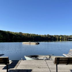
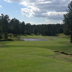
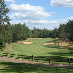
We stayed in Tomahawk, WI for an extended holiday weekend and were looking for a spot to do some paddle boarding. While there's tons of lakes in the area, not all of them are ideal for paddle boarding. Buck Lake (which is part of the Almon Recreational Area) most definitely is! They don't rent out paddle boards right at the lake, so if you don't have your own, you'll definitely have to rent one elsewhere and bring it here. We have our own, so that wasn't a problem. The Almon Recreation Area includes a paved path leading to a small beach and nice little swimming area in Buck Lake. The beach also offers a great launching point for paddle boards. The lake itself is relatively small and wake free, so, even if the beach area is busy, you can easily paddle out to serenely crowd free conditions. We went three days in a row on a holiday weekend and only ever came within shouting distance of one canoe and one paddle boat. Beyond that, we had the lake to ourselves. Just above the beach is a wooded picnic area, complete with grills, picnic tables, and bathrooms. The recreation area also includes (down a separate paved path) a pretty epic frisbee golf course that meanders through the woods as well a trail system if you're looking to take scenic hike. Leashed dogs are allowed on the trail system. No pets (leashed or otherwise) are allowed at the beach/picnic area. read more


5 years ago
We stopped here twice on our recent excursion to Upper Michigan. It was a great place to walk our dogs and for me to tryout my new GRIT Freedom Chair. We went a little way off road and also used the paved path. Loved the areas we got see and can't wait to go back and explore some more! read more
More info about Almon Recreation Area
5340 Hixon Lake Rd
Rhinelander, WI 54501
Directions
Hours
Indoor Amenities
Outdoor Amenities


Almon Recreation Area - parks - Updated July 2026
Best of Rhinelander
People found Almon Recreation Area by searching for…
Beaches in Rhinelander, Wisconsin
Things to Do in Rhinelander, Wisconsin
Hiking Trails in Rhinelander, Wisconsin
Dog Parks in Rhinelander, Wisconsin
Swimming Lakes in Rhinelander, Wisconsin
Waterfalls in Rhinelander, Wisconsin
Places to Take Pictures in Rhinelander, Wisconsin
Boating in Rhinelander, Wisconsin
Disc Golf in Rhinelander, Wisconsin
Attractions in Rhinelander, Wisconsin
Playgrounds in Rhinelander, Wisconsin
Walking Trails in Rhinelander, Wisconsin
Dog Friendly Places in Rhinelander, Wisconsin
Playgrounds for Kids in Rhinelander, Wisconsin
Picnic Parks in Rhinelander, Wisconsin
Picnic Areas in Rhinelander, Wisconsin
Parks for Kids in Rhinelander, Wisconsin
Paddle Boat in Rhinelander, Wisconsin
Boat Rental in Rhinelander, Wisconsin
Places to Swim in Rhinelander, Wisconsin
Swimming Holes in Rhinelander, Wisconsin
Boat Launch in Rhinelander, Wisconsin
Trending Searches in Rhinelander, WI
Boat Launch near Almon Recreation Area
Boat Rental near Almon Recreation Area
Day Trips near Almon Recreation Area
Fireworks near Almon Recreation Area
Jet Ski Rental near Almon Recreation Area
Kayak Rental near Almon Recreation Area
Lakes near Almon Recreation Area
Picnic Areas near Almon Recreation Area
Places To Swim near Almon Recreation Area
Places To Take Pictures near Almon Recreation Area
Playgrounds near Almon Recreation Area
Public Shower near Almon Recreation Area
River Tubing near Almon Recreation Area
Swimming Holes near Almon Recreation Area
Browse Articles
Browse Nearby
Browse Brands
Related Searches in Rhinelander, WI
Affordable Canoe Rental Options in Rhinelander, Wisconsin
Best Boat Launch Spots in Rhinelander, Wisconsin
Best Fishing Locations and Guides in Rhinelander, Wisconsin
Best Fun Things to Do in Rhinelander, Wisconsin
Best Nature Trails for Hiking in Rhinelander, Wisconsin
Best Places for Horseback Riding in Rhinelander, Wisconsin
Best Places for Stunning Views in Rhinelander, Wisconsin
Best Pontoon Boat Rentals Near Rhinelander, Wisconsin
Best Sledding Spots and Fun in Rhinelander, Wisconsin
Check Out Great Playgrounds in Rhinelander, Wisconsin
Check Out Off Road Trails in Rhinelander, Wisconsin
Discover Fun Activities to Do in Rhinelander, Wisconsin
Discover Popular Bike Trails in Rhinelander, Wisconsin
Discover Popular Photo Spots in Rhinelander, Wisconsin
Discover Top Boat Tours in Rhinelander, Wisconsin for All Ages
Discover Top Nature Parks to Visit in Rhinelander, Wisconsin
Discover the Best Beaches in Rhinelander, Wisconsin
Discover the Best Fishing Lake in Rhinelander, Wisconsin
Enjoy Kayaking Adventures in Rhinelander, Wisconsin
Enjoy the Best Picnic Spots and Ideas in Rhinelander, Wisconsin
Enjoy the Best Tubing Experiences in Rhinelander, Wisconsin
Explore Beautiful Parks and Green Spaces in Rhinelander, Wisconsin
Explore Bike Rentals Throughout Rhinelander, Wisconsin
Explore Free Things to Do Around Rhinelander, Wisconsin
Explore Fun Activities to Do in Rhinelander, Wisconsin
Explore Nature Spots Around Rhinelander, Wisconsin
Explore Parks With Lakes to Visit in Rhinelander, Wisconsin
Explore Popular Campgrounds Near Rhinelander, Wisconsin
Explore Popular Picnic Areas Around Rhinelander, Wisconsin
Explore Popular Scenic Overlook Points in Rhinelander, Wisconsin
Explore Popular View Points Around Rhinelander, Wisconsin
Explore Scenic Lakes to Visit in Rhinelander, Wisconsin
Explore Summer Camps for All Ages in Rhinelander, Wisconsin
Explore Top Gyms in Rhinelander, Wisconsin Now
Explore Top Marinas Near Rhinelander, Wisconsin
Explore the Best Boating Spots in Rhinelander, Wisconsin
Explore the Best Trail Options in Rhinelander, Wisconsin
Family Friendly Hiking With Kids in Rhinelander, Wisconsin
Find Beautiful Views in Rhinelander, Wisconsin
Find Cozy Camping Cabins in Rhinelander, Wisconsin
Find Fun Kids Activities Outdoor in Rhinelander, Wisconsin
Find Fun Things to Do With Kids in Rhinelander, Wisconsin
Find Parks and Recreation Activities in Rhinelander, Wisconsin
Find Picnic Tables for Outdoor Fun in Rhinelander, Wisconsin
Find Top Skating Rinks in Rhinelander, Wisconsin for All Ages
Find Top-Rated Waterfalls in Rhinelander, Wisconsin Now
Find the Best Parks for Picnics in Rhinelander, Wisconsin
Find the Best Playgrounds to Visit in Rhinelander, Wisconsin
People who viewed Almon Recreation Area also viewed
Northwoods Zip Line Tours
21 reviews
schlecht lake trail
1 review
Three Eagle Trail
3 reviews
Settlers Mill
11 reviews
$$
Holiday Acres Riding Academy Go Karts/Miniature Golf
20 reviews
Scotties Bait & Tackle
6 reviews
Clear Lake Inn and Resort
11 reviews
Lakeside Marina
16 reviews
Z-Best Bikes
9 reviews
$$$
Island City Lanes & Lounge
14 reviews