York County Rail Trail Authority Photos


More like York County Rail Trail Authority
Recommended Reviews - York County Rail Trail Authority
Start your review...

8 years ago
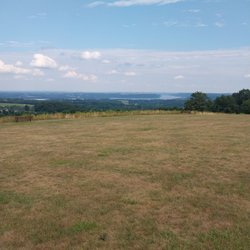
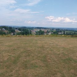
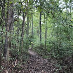
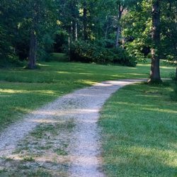
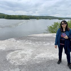
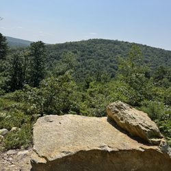
The Rail Trail is a great place to walk or bike ride. The scene changes depending on where you are. Some spots are in the city or borough while others are deep woods. Because of the length of the trail there are many places to park and get a different experience every time. Two historic stations still exist from when passenger trains used the tracks; the Hanover Junction station and New Freedom station. Hanover Junction is famous for a stop by Abraham Lincoln on route to Gettysburg in 1863 and charged trains. Both stations are open weekends in the summer. Riding through Howard Tunnel is also a fun experience. From New Freedom you can ride the Steam Into History train on a Civil War era train. Different themes such as Halloween and Christmas are added in season and sometimes Abraham Lincoln joins the ride. read more


More info about York County Rail Trail Authority


York County Rail Trail Authority - hiking - Updated May 2026
Best of Seven Valleys
People found York County Rail Trail Authority by searching for…
Parks in Seven Valleys, Pennsylvania
Things to Do in Seven Valleys, Pennsylvania
Running Trails in Seven Valleys, Pennsylvania
Walking Trails in Seven Valleys, Pennsylvania
Hiking Trails in Seven Valleys, Pennsylvania
Secluded Spots in Seven Valleys, Pennsylvania
Waterfall Hike in Seven Valleys, Pennsylvania
Dog Friendly Trails in Seven Valleys, Pennsylvania
Off Road Trails in Seven Valleys, Pennsylvania
Easy Hikes in Seven Valleys, Pennsylvania
Off Leash Dog Hikes in Seven Valleys, Pennsylvania
Scenic View in Seven Valleys, Pennsylvania
Bike Path in Seven Valleys, Pennsylvania
Trail in Seven Valleys, Pennsylvania
View Points in Seven Valleys, Pennsylvania
Scenic Overlook in Seven Valleys, Pennsylvania
Lakes & Ponds in Seven Valleys, Pennsylvania
Mountain Biking in Seven Valleys, Pennsylvania
Creeks in Seven Valleys, Pennsylvania
To Do in Seven Valleys, Pennsylvania
Running Tracks Open to the Public in Seven Valleys, Pennsylvania
Places to Take Pictures in Seven Valleys, Pennsylvania
Trending Searches in Seven Valleys, PA
Browse Articles
Browse Nearby
BEST of Seven Valleys, Pennsylvania Restaurants near York County Rail Trail Authority
BEST of Seven Valleys, Pennsylvania Parks near York County Rail Trail Authority
BEST of Seven Valleys, Pennsylvania Coffee near York County Rail Trail Authority
BEST of Seven Valleys, Pennsylvania Things to Do near York County Rail Trail Authority
BEST of Seven Valleys, Pennsylvania Lakes near York County Rail Trail Authority
BEST of Seven Valleys, Pennsylvania Hotels near York County Rail Trail Authority
BEST of Seven Valleys, Pennsylvania Breakfast near York County Rail Trail Authority
BEST of Seven Valleys, Pennsylvania Campgrounds near York County Rail Trail Authority
Browse Brands
Related Searches in Seven Valleys, PA
Best Fishing Locations and Guides in Seven Valleys, Pennsylvania
Best Lookout Points to Visit in Seven Valleys, Pennsylvania
Best Nature Trails for Hiking in Seven Valleys, Pennsylvania
Best Places for Horseback Riding in Seven Valleys, Pennsylvania
Best Spots for Star Gazing in Seven Valleys, Pennsylvania
Best Waterfalls and Swimming Holes in Seven Valleys, Pennsylvania
Check Out Off Road Trails in Seven Valleys, Pennsylvania
Discover Dog Friendly Beaches Near Seven Valleys, Pennsylvania
Discover Scenic Mountain Bike Trails Near Seven Valleys, Pennsylvania
Discover Top Nature Parks to Visit in Seven Valleys, Pennsylvania
Discover a Hiking Trail in Seven Valleys, Pennsylvania
Discover the Best Night Hike Trails in Seven Valleys, Pennsylvania
Dog-Friendly Hikes With Dogs in Seven Valleys, Pennsylvania
Effective Stairs Workout Spots in Seven Valleys, Pennsylvania
Enjoy Exciting Mountain Biking Adventures in Seven Valleys, Pennsylvania
Enjoy Scenic Night View Experiences in Seven Valleys, Pennsylvania
Enjoy the Best Tubing Experiences in Seven Valleys, Pennsylvania
Enjoy the Best Walking Trails in Seven Valleys, Pennsylvania
Exciting Cliff Jumping Spots in Seven Valleys, Pennsylvania
Experience Stunning Sunset Views in Seven Valleys, Pennsylvania
Explore Beautiful Parks and Green Spaces in Seven Valleys, Pennsylvania
Explore Bike Rentals Throughout Seven Valleys, Pennsylvania
Explore Easy Hikes Perfect for All in Seven Valleys, Pennsylvania
Explore Popular Campgrounds Near Seven Valleys, Pennsylvania
Explore Popular Scenic Overlook Points in Seven Valleys, Pennsylvania
Explore Scenic Lakes to Visit in Seven Valleys, Pennsylvania
Explore Secret Spots Worth Visiting in Seven Valleys, Pennsylvania
Explore the Best Swimming Holes Around Seven Valleys, Pennsylvania
Explore the Best Trail Options in Seven Valleys, Pennsylvania
Family Friendly Hiking With Kids in Seven Valleys, Pennsylvania
Find Beautiful Views in Seven Valleys, Pennsylvania
Find Fun Kids Activities Outdoor in Seven Valleys, Pennsylvania
Find Parks and Recreation Activities in Seven Valleys, Pennsylvania
Find the Best Parks for Picnics in Seven Valleys, Pennsylvania
Find the Best Playgrounds to Visit in Seven Valleys, Pennsylvania
Find the Best Scenic View Locations in Seven Valleys, Pennsylvania
Find the Best Swimming Pools in Seven Valleys, Pennsylvania Today
Hiking Trails With Waterfalls in Seven Valleys, Pennsylvania
Off Leash Dog Hiking Trails in Seven Valleys, Pennsylvania
Perfect Spots to Watch Sunset in Seven Valleys, Pennsylvania
Plan a Scenic Drive Route Near Seven Valleys, Pennsylvania
Popular Fishing Spots to Explore in Seven Valleys, Pennsylvania
Popular Kids Activities in Seven Valleys, Pennsylvania
Popular Picnic Spots to Visit in Seven Valleys, Pennsylvania
Popular Things to Do in Seven Valleys, Pennsylvania
Safe River Swimming Areas in Seven Valleys, Pennsylvania
Top Running Trails to Explore in Seven Valleys, Pennsylvania
Top Swimming Lakes to Enjoy in Seven Valleys, Pennsylvania
Visit Popular BBQ Park Locations in Seven Valleys, Pennsylvania
Walk Dog Friendly Hiking Trails in Seven Valleys, Pennsylvania
People who viewed York County Rail Trail Authority also viewed
Heritage Rail Trail
15 reviews
Northwest Lancaster County River Trail
8 reviews
NCR Bike Trail
1 review
PPL Holtwood Environmental Preserve
2 reviews
Columbia River Park
1 review
William H Kain Memorial Park
2 reviews
Lake Redman Boardwalk
1 review
Sunset Lane Park
2 reviews
Musser Park
2 reviews
Stonewood Park
2 reviews