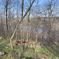
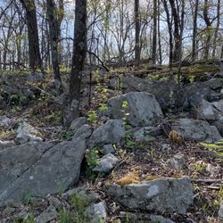
WildCat Ridge Reservation Trail Photos


You might also consider
More like WildCat Ridge Reservation Trail
Recommended Reviews - WildCat Ridge Reservation Trail
Start your review...

6 months ago
Great place, peaceful. I love go there Almost every Saturday morning Helping me found my self together... read more


2 years ago
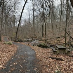
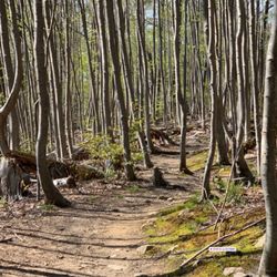
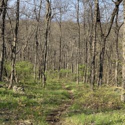
The reservation has multiple trails for the inspired hiker. Four birds trail, Hibernia trail, Split rock trail, Beach trail are some of available trails. I hiked both four birds and Hibernia trails. Since these trails were poorly maintained these were the least liked of the trails i have hiked in NJ. The trail is heavily wooded and not much to see. Also the poor trail maintenance caused me to need to push plants aside and step over them aswell. The reward was the beautiful Hawk Overlook. A high, rocky cliff side overlooking the NJ forest. Gorgeous and peaceful! read more


9 years ago
I agree with Tony about this hike, the trails are poorly maintained. There's some parking down by the sign, enough for those walking through. My brother and I decided to follow the Hibernian trail (orange) all the up to the ridge. You're rewarded with a spectacular view and greens and ridges. The only thing that hindered this hike were the poor markers, at times my brother and I had to scout for the orange and there were no signs/arrows indicating where the orange trail would go. Similarly there were also indicator for the beginning orange markers when we were still on the same orange from the beginning of the parking lot. Having a definite path would suit this place well. I would definitely go here again and would love to see work done on the trails. read more


8 years ago
More info about WildCat Ridge Reservation Trail
10 S Church St
Rockaway, NJ 07866
Directions
Hours
Outdoor Amenities


WildCat Ridge Reservation Trail - hiking - Updated May 2026
Best of Rockaway
People found WildCat Ridge Reservation Trail by searching for…
Beaches in Rockaway, New Jersey
Walking Trails in Rockaway, New Jersey
Running Trails in Rockaway, New Jersey
Hiking Trails in Rockaway, New Jersey
Beautiful Views in Rockaway, New Jersey
Swimming Lakes in Rockaway, New Jersey
Scenic Overlook in Rockaway, New Jersey
Things to Do in Rockaway, New Jersey
Scenic View in Rockaway, New Jersey
Lakes & Ponds in Rockaway, New Jersey
Easy Hikes in Rockaway, New Jersey
Cliff Diving in Rockaway, New Jersey
View Points in Rockaway, New Jersey
Skyline View in Rockaway, New Jersey
Off Road Trails in Rockaway, New Jersey
Waterfall Hike in Rockaway, New Jersey
Walking Path in Rockaway, New Jersey
Off Leash Dog Hikes in Rockaway, New Jersey
Lookout Points in Rockaway, New Jersey
Trending Searches in Rockaway, NJ
Boat Rental near WildCat Ridge Reservation Trail
Botanical Gardens near WildCat Ridge Reservation Trail
Bounce House Rentals near WildCat Ridge Reservation Trail
Campgrounds near WildCat Ridge Reservation Trail
Cherry Picking near WildCat Ridge Reservation Trail
Cliff Jumping near WildCat Ridge Reservation Trail
Dog Friendly Things To Do near WildCat Ridge Reservation Trail
Flower Fields near WildCat Ridge Reservation Trail
Flower Shop near WildCat Ridge Reservation Trail
Garage Sales near WildCat Ridge Reservation Trail
Hair near WildCat Ridge Reservation Trail
Lakes & Ponds near WildCat Ridge Reservation Trail
Nurseries & Gardening near WildCat Ridge Reservation Trail
Outdoor Activities near WildCat Ridge Reservation Trail
Outdoor Furniture Stores near WildCat Ridge Reservation Trail
Parks near WildCat Ridge Reservation Trail
Party Equipment Rentals near WildCat Ridge Reservation Trail
Pedicure near WildCat Ridge Reservation Trail
Pick Your Own Farms near WildCat Ridge Reservation Trail
Picnic Areas near WildCat Ridge Reservation Trail
Places To Take Pictures near WildCat Ridge Reservation Trail
Running Trails near WildCat Ridge Reservation Trail
Scenic Drive near WildCat Ridge Reservation Trail
Secret Spots near WildCat Ridge Reservation Trail
Strawberry Picking near WildCat Ridge Reservation Trail
Sunrise View near WildCat Ridge Reservation Trail
Swimming Holes near WildCat Ridge Reservation Trail
Table And Chair Rentals near WildCat Ridge Reservation Trail
Browse Articles
Browse Nearby
BEST of Rockaway, New Jersey Things to Do near WildCat Ridge Reservation Trail
BEST of Rockaway, New Jersey Restaurants near WildCat Ridge Reservation Trail
BEST of Rockaway, New Jersey Coffee near WildCat Ridge Reservation Trail
BEST of Rockaway, New Jersey Walking Trails near WildCat Ridge Reservation Trail
BEST of Rockaway, New Jersey Parks near WildCat Ridge Reservation Trail
BEST of Rockaway, New Jersey Breakfast near WildCat Ridge Reservation Trail
BEST of Rockaway, New Jersey Hotels near WildCat Ridge Reservation Trail
Browse Brands
Related Searches in Rockaway, NJ
Affordable Kayak Rental Services in Rockaway, New Jersey
Best Fishing Locations and Guides in Rockaway, New Jersey
Best Nature Trails for Hiking in Rockaway, New Jersey
Best Places for Horseback Riding in Rockaway, New Jersey
Best Waterfalls and Swimming Holes in Rockaway, New Jersey
Check Out Off Road Trails in Rockaway, New Jersey
Discover Dog Friendly Trails to Explore in Rockaway, New Jersey
Discover Kid Friendly Hiking Trails in Rockaway, New Jersey
Discover Scenic Mountain Bike Trails Near Rockaway, New Jersey
Discover Scenic Waterfall Spots in Rockaway, New Jersey
Discover a Hiking Trail in Rockaway, New Jersey
Discover the Best Night Hike Trails in Rockaway, New Jersey
Enjoy Camping Adventures Around Rockaway, New Jersey
Enjoy Kayaking Adventures in Rockaway, New Jersey
Enjoy Tent Camping Spots Around Rockaway, New Jersey
Enjoy the Best Picnic Spots and Ideas in Rockaway, New Jersey
Enjoy the Best Walking Path in Rockaway, New Jersey
Enjoy the Best Walking Trails in Rockaway, New Jersey
Exciting Cliff Jumping Spots in Rockaway, New Jersey
Experience Thrilling White Water Rafting in Rockaway, New Jersey
Explore Beautiful Parks and Green Spaces in Rockaway, New Jersey
Explore Fun Activities to Do in Rockaway, New Jersey
Explore Popular Campgrounds Near Rockaway, New Jersey
Explore Popular Scenic Overlook Points in Rockaway, New Jersey
Explore Scenic Lakes to Visit in Rockaway, New Jersey
Explore the Best Beach Spots in Rockaway, New Jersey
Explore the Best Boating Spots in Rockaway, New Jersey
Explore the Best Swimming Holes Around Rockaway, New Jersey
Explore the Best Trail Options in Rockaway, New Jersey
Family Friendly Hiking With Kids in Rockaway, New Jersey
Find Beautiful Views in Rockaway, New Jersey
Find Popular Ziplining Spots Around Rockaway, New Jersey
Find the Best Parks for Picnics in Rockaway, New Jersey
Find the Best Playgrounds to Visit in Rockaway, New Jersey
Find the Best Scenic View Locations in Rockaway, New Jersey
Hiking Trails With Waterfalls in Rockaway, New Jersey
Plan a Scenic Drive Route Near Rockaway, New Jersey
Popular Fishing Spots to Explore in Rockaway, New Jersey
Popular Outdoor Activities to Try in Rockaway, New Jersey
Popular Picnic Spots to Visit in Rockaway, New Jersey
Safe River Swimming Areas in Rockaway, New Jersey
Safe and Fun Parks for Kids in Rockaway, New Jersey
Top Climbing Spots and Gyms in Rockaway, New Jersey
Top Paddleboarding Activities in Rockaway, New Jersey
Top Places for Snorkeling in Rockaway, New Jersey
Top Running Trails to Explore in Rockaway, New Jersey
Top Swimming Lakes to Enjoy in Rockaway, New Jersey
Top Swimming Spots and Pools in Rockaway, New Jersey
People who viewed WildCat Ridge Reservation Trail also viewed
Tourne County Park
15 reviews
Freedom Park
2 reviews
friendship park
2 reviews
Paulinskill Valley Rail Trail
2 reviews
New Jersey Audubon's Scherman Hoffman Wildlife Sanctuary
6 reviews
Mountain Way Park
4 reviews
Troy Meadows Natural Area
2 reviews
Parks Lake
2 reviews
Hurd Park
5 reviews
Schooley’s Mountain County Park
1 review