Farny State Park Photos


You might also consider
More like Farny State Park
Recommended Reviews - Farny State Park
Start your review...

***3 1/2 stars*** I was a little surprised when I saw how low the average rating was for this place; typically parks and hiking trails tend to have inflated/positive reviews, mostly because the only people willing to write them love being outdoors. However, it's really hard to argue. This was probably by fifth time here yesterday, and I'm never blown away by the experience. The hike I do here is featured in njhiking.com (which is a massively strong recommend - great, detailed and varied hikes featured all over the site) as one of the most challenging hikes in the state. It's an 11.1-miler that starts out at the boat launch parking lot on Splitrock Road (and there is ALWAYS a port-a-potty there - strong selling point; very clean this time too), goes east for about half a mile to the white trail, cuts south mostly through the woods and occasionally alongside the reservoir, switches to the blue trail by the southern end, goes up Buck Mountain and then continues mostly north back up to the road and the boat launch. It's a nasty hike (rugged with constant up and down), but it's one I like to do as training prep when I'm about to do a crazy adventure somewhere in the country - if you can do this one pretty easily, you can literally do almost any hike that doesn't involve massive rock climbing or something. In my opinion at least (and I AM in excellent hiking shape right now, full disclosure) the most difficult or challenging part of this is just the mileage. The up and down isn't as extreme as, say, a hike up in Norvin Green where you're literally going up an incline for a solid 15 or 20 minutes multiple times. There's one quick scramble up the mountain that took less than five minutes, and maybe one or two other sharper inclines that were shorter in length than that. But cumulatively, you're going to feel it toward the end of the hike, even though that part is largely on a woods road. I tend to meander and not bulldoze ahead (journey not the destination), so this whole hike took me six hours and 38 minutes. Start early. The primary reason I'm always tepid about this one is that SO much of it is just in the woods with no viewpoints. I'm of the opinion that if you have sweat pouring off of you and sore hindpaws, you'd better have a few majestic vistas or something for the payoff. Aside from the obvious reservoir optics from time to time, there also aren't a lot of exciting natural features to get hot and bothered about. You really just have one view up on Buck Mountain, and for whatever reason, I always seem to be over here on a meh, mostly overcast day. And this is sort of a pro and a con, but this is not a popular hike. Yes, you're not contending with hoards of people and the ones you do are CLEARLY legit hikers - there's no one wearing Uggs asking if you have extra water - but it means the canine situation is pretty barebones. Obviously a personal issue that may not apply to other prospective adventurers. That said, the wildlife game is always pretty abundant and yesterday was no exception. There were tons of frogs/toads, and I saw at least two skinks yesterday (the corgis of reptiles). There were also quite a few representatives of the waterfowl family hanging out on the edges of the reservoir, including one or two swans. The snake game was nuts, and both took place toward the end on the blue trail with maybe a mile or two to go. First I encountered a garter snake who was very on edge and tried to lunge at me (which I just rolled my eyes at), but then a few minutes later I came within a foot of a long black racer snake that mimicked a rattlesnake with the intentional rattling of its tail, which I've NEVER seen before, and that was a bit jarring. But I continued on, no worse for wear. I always enjoy being able to eat an entire pizza guilt-free and chuckling at the temporary loss of water weight from this hike, but this isn't one that I enjoy all that much. It gets you in shape and doesn't have much in the way of other selling points unless you're really into snakes with low self-esteem. read more


5 years ago
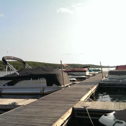
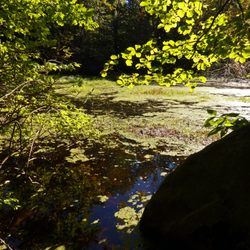
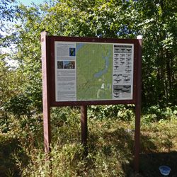
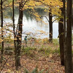
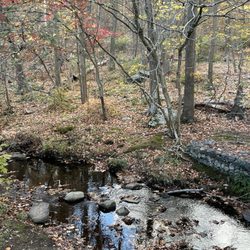
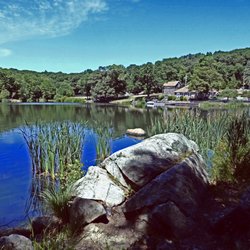
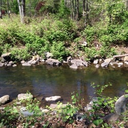
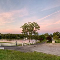
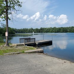
Farney State Park is a 589 acre mature mixed hardwood forest in Northern New Jersey. Tall red, white and black oak trees dominate the canopy, The park is a habitat for the red-shouldered hawk and barred owl both of which are endangered. Be aware that there are ticks, bears and copperhead and eastern rattle snakes in the area. The terrain is rocky and features streams, stone walls, dams, a bridge and Split Rock Reservoir. The reservoir is part of the Wildcat Ridge Wildlife Management Area. The reservoir is open to kayaking which I do a great deal of since it is so close to where I live. You can also canoe or bring your boat, only electric motors though. There are two car=top launches on the the reservoir. No swimming is allowed and if a ranger sees your feet in the water, you will be reprimanded. Both use of alcohol, smoking or vaping is not permitted. There is a 13 mile loop around the reservoir with other shorter trails of varying difficulty. People come to Farney State to bird watch, fish (16+ need NJ license ), hunt in selected areas, ice fish, and hike. The Split Rock site was used as a production area during the Revolutionary War for producing iron. A furnace can still be seen if you take the trail down the road toward the bridge. It is down the slope by the overflow of the reservoir. There are trail maps on-line. Your phone GPS will work in this area as well. Signage is mixed in this State Park. The bridge crossing on the reservoir dam is one way but there is a red/green light system. ADMISSION IS FREE. Ten minutes from my home, it is my go to kayaking spot. read more


The four Birds Trail is pretty difficult to find from the main parking lot. So to find it I would recommend to park at the main lot then walk up the road until you see the white Blaze indicating the entrance to the four Birds Trail. The scenery doesn't change during the 13 Mile loop around Split Rock Reservoir. Its actually quite mundane. I was screaming to the heavens to give me a boat so that I could just boat back to the lot after only 5 miles. Yet there is no turning back in life-only forward... so I continued along the extremely rocky and hilly trail until it's completion. Be sure to take a picture of the trail map at the start of the trail or you will get lost. The blazes are not always easy to spot.. you'll need to reference your map several times during your hike. Use deet spray!!! Lots of buzzing inquisitive flies want to touch your face and greet you through the 13 Mile loop as well as the several ticks that you will certainly find on your body. Happy hiking! read more


11 years ago
More info about Farny State Park
You might also consider


Farny State Park - hiking - Updated May 2026
Best of Rockaway Township
People found Farny State Park by searching for…
Lakes in Rockaway Township, New Jersey
Things to Do in Rockaway Township, New Jersey
Rock Climbing in Rockaway Township, New Jersey
Fishing Spots in Rockaway Township, New Jersey
Hiking Trails in Rockaway Township, New Jersey
Walking Trails in Rockaway Township, New Jersey
Places to Take Pictures in Rockaway Township, New Jersey
Boat Launch in Rockaway Township, New Jersey
Fishing Lake in Rockaway Township, New Jersey
Easy Hikes in Rockaway Township, New Jersey
Swimming Lakes in Rockaway Township, New Jersey
Rattlesnake in Rockaway Township, New Jersey
Scenic View in Rockaway Township, New Jersey
Off Road Trails in Rockaway Township, New Jersey
Watch Sunset in Rockaway Township, New Jersey
Scenic Overlook in Rockaway Township, New Jersey
Running Trails in Rockaway Township, New Jersey
Marinas in Rockaway Township, New Jersey
Boating in Rockaway Township, New Jersey
View Points in Rockaway Township, New Jersey
Sunset View in Rockaway Township, New Jersey
Fishing License in Rockaway Township, New Jersey
Browse Nearby
Browse Brands
Browse Articles
People who viewed Farny State Park also viewed
Abram S Hewitt State Forest
5 reviews
Franklin Lakes Nature Preserve
16 reviews
Ringwood State Park at Ringwood Manor
48 reviews
Sterling Forest State Park
20 reviews
Stephens State Park
5 reviews
Rifle Camp Park
14 reviews
Morris Canal
1 review
New Jersey Botanical Garden
20 reviews
Jacqueline Kennedy Onassis Reservoir
111 reviews
Central Park
Rockefeller Lookout
9 reviews